Pricing Guides & Dictionary of Makers Marks for Antiques & Collectibles
A few examples of appraisal values for
SEAT OF WAR
Search our price guide for your own treasures
-
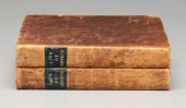
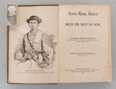 A.T. GOODLOE: SOME REBEL RELICS
 [CIVIL WAR] 1893Goodloe, Albert Theodore. SOME REBEL RELICS FROM THE SEAT OF WAR. Member of John L. McEwen Bivouac No. 4, Franklin Tenn. Nashville: Printed for the author. Publishing House of the Methodist Episcopal Church, South. 1893. 315pp. First Edition. 7 1/2" H x 5 3/8" W x 1" D. (Higher-resolution photos are available at www.caseantiques.com) Condition: Publisher's decorated boards, soiled and faded. Spine faded and soiled with personal(?) library number "25" on spine. Bumped corners with some edgewear to boards. Some soiling to pages 208-209, otherwise text in good condition.
A.T. GOODLOE: SOME REBEL RELICS
A.T. GOODLOE: SOME REBEL RELICS [CIVIL WAR] 1893Goodloe, Albert Theodore. SOME REBEL RELICS FROM THE SEAT OF WAR. Member of John L. McEwen Bivouac No. 4, Franklin Tenn. Nashville: Printed for the author. Publishing House of the Methodist Episcopal Church, South. 1893. 315pp. First Edition. 7 1/2" H x 5 3/8" W x 1" D. (Higher-resolution photos are available at www.caseantiques.com) Condition: Publisher's decorated boards, soiled and faded. Spine faded and soiled with personal(?) library number "25" on spine. Bumped corners with some edgewear to boards. Some soiling to pages 208-209, otherwise text in good condition. -
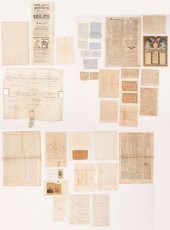 32 PCS MISCELLANEOUS AUTOGRAPHS AND
 EPHEMERA INC. 1825 ...Group of Assorted Ephemera, 1779-1940s. Includes: 1825 Diploma on vellum, University of Pennsylvania, signed by Frederick Beasley, R.M. Patterson and others; 1 Author and historian Henry Lee of Virginia 1827 ALS, 4 pp, large folio, to Lt. Col. Cockburn sending a large collection of revolutionary papers and letters with comments on each of the great names; 1 Magic Show Broadside for the Adelphi Theater, London, 1853; 2 CDVs picturing carnival performers "General Mite: The Smallest Man in the World" and an unidentified female entertainer of similarly small stature; the July 5, 1847 edition o of the Nashville Orthopolitan newspaper, endorsing Zachary Taylor for president; 1 Author (not the politician) Winston Churchill undated ALS referencing Rattle and Snap plantation in Columbia, TN; 1 Clipped signature of Missouri senator Thomas Hart Benton; 1 Artist William Merritt Chase brief signed handwritten note proposing John Twachtmann for membership in the American Watercolor Society (plus 2 other signatures, illegible); plus 1 land indenture referencing land in Franklin County, Alabama,1838; legal documents from Hempstead County, Arkansas Territory, 1822 and 1823, and Jackson County, Alabama 1821; Correspondence from John Williamson, Mexico, 1850; C.E. Beall, Texas, 1859; Paul McDermott, Pittsburgh, 1796; Dorothy Kelly, Marlborough, 1865; and 1 letter, signature illegible, to Mr. John Bacon, Edgefield, SC; plus 1 sheet handwritten undated but early instructions on how to fire a rifle; eight (8) Nashville and Northwestern Railroad Tax Receipts for 1872 (on 2 sheets); two (2) Prohibition era prescriptions for Whiskey; 1 printed poem "Avery Meriwether"; 1 small silk portrait of James K Polk with facsimile signature printed by Mogul's Cigarettes; 1 "America's Roll of Honor" blank certificate printed by Metropolitan Life of Jackson, TN circa 1930s-40s; 5 European 19th century receipts, and 2 London Newspapers: The Public Advertiser, dated August 18, 1779 and July 24, 1780 (with Thomas Paine article on the Revolutionary War, predicting "The Carolinas will be the seat of war this summer.") Condition: Diploma is folded and some signatures faded. Overall fading and a 3" area of loss to Lee letter. Other items generally good condition with light toning, fading, scattered stains and small losses, most items encapsulated or housed in protective plastic sheeting. London newspapers in very fragile condition.
32 PCS MISCELLANEOUS AUTOGRAPHS AND
32 PCS MISCELLANEOUS AUTOGRAPHS AND EPHEMERA INC. 1825 ...Group of Assorted Ephemera, 1779-1940s. Includes: 1825 Diploma on vellum, University of Pennsylvania, signed by Frederick Beasley, R.M. Patterson and others; 1 Author and historian Henry Lee of Virginia 1827 ALS, 4 pp, large folio, to Lt. Col. Cockburn sending a large collection of revolutionary papers and letters with comments on each of the great names; 1 Magic Show Broadside for the Adelphi Theater, London, 1853; 2 CDVs picturing carnival performers "General Mite: The Smallest Man in the World" and an unidentified female entertainer of similarly small stature; the July 5, 1847 edition o of the Nashville Orthopolitan newspaper, endorsing Zachary Taylor for president; 1 Author (not the politician) Winston Churchill undated ALS referencing Rattle and Snap plantation in Columbia, TN; 1 Clipped signature of Missouri senator Thomas Hart Benton; 1 Artist William Merritt Chase brief signed handwritten note proposing John Twachtmann for membership in the American Watercolor Society (plus 2 other signatures, illegible); plus 1 land indenture referencing land in Franklin County, Alabama,1838; legal documents from Hempstead County, Arkansas Territory, 1822 and 1823, and Jackson County, Alabama 1821; Correspondence from John Williamson, Mexico, 1850; C.E. Beall, Texas, 1859; Paul McDermott, Pittsburgh, 1796; Dorothy Kelly, Marlborough, 1865; and 1 letter, signature illegible, to Mr. John Bacon, Edgefield, SC; plus 1 sheet handwritten undated but early instructions on how to fire a rifle; eight (8) Nashville and Northwestern Railroad Tax Receipts for 1872 (on 2 sheets); two (2) Prohibition era prescriptions for Whiskey; 1 printed poem "Avery Meriwether"; 1 small silk portrait of James K Polk with facsimile signature printed by Mogul's Cigarettes; 1 "America's Roll of Honor" blank certificate printed by Metropolitan Life of Jackson, TN circa 1930s-40s; 5 European 19th century receipts, and 2 London Newspapers: The Public Advertiser, dated August 18, 1779 and July 24, 1780 (with Thomas Paine article on the Revolutionary War, predicting "The Carolinas will be the seat of war this summer.") Condition: Diploma is folded and some signatures faded. Overall fading and a 3" area of loss to Lee letter. Other items generally good condition with light toning, fading, scattered stains and small losses, most items encapsulated or housed in protective plastic sheeting. London newspapers in very fragile condition. -
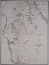 1836 FLORIDA "SEAT OF WAR" MAP,
 TAMPA BAYAntique map showing the Seat of War in Florida, 1836, including Indian Villages, General Gains Camps, Battles Fought, Houses Picketed and the Camps of General Scott's Army. Nicely framed. Some light soiling. Sight size is 10 1/2" x 14 1/2". Framed size is 18" x 22".
1836 FLORIDA "SEAT OF WAR" MAP,
1836 FLORIDA "SEAT OF WAR" MAP, TAMPA BAYAntique map showing the Seat of War in Florida, 1836, including Indian Villages, General Gains Camps, Battles Fought, Houses Picketed and the Camps of General Scott's Army. Nicely framed. Some light soiling. Sight size is 10 1/2" x 14 1/2". Framed size is 18" x 22". -
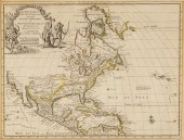 GROUP OF FIVE MAPS I' Amerique
 Septentrionale Suivant les Nouvelles Obfervations de Mess del' Academic Royale des Sciences, etc. Augmentees de Nouveau. A Amsterdam Chez Covens et Mortimer. Part of North America containing Canada and North Parts of New England and New York with Nova Scotia and Newfound Land From the s! Robert with Improvements. North America agreeable to the moft approved maps and charts. By Tho Conder. A New and Accurate Map of the present Seat of War in North America. McNally's System of Geography, Map No 8.
GROUP OF FIVE MAPS I' Amerique
GROUP OF FIVE MAPS I' Amerique Septentrionale Suivant les Nouvelles Obfervations de Mess del' Academic Royale des Sciences, etc. Augmentees de Nouveau. A Amsterdam Chez Covens et Mortimer. Part of North America containing Canada and North Parts of New England and New York with Nova Scotia and Newfound Land From the s! Robert with Improvements. North America agreeable to the moft approved maps and charts. By Tho Conder. A New and Accurate Map of the present Seat of War in North America. McNally's System of Geography, Map No 8. -
 EDWARD BAINES MAP US CANADIAN
 FRONTIER 1816Map United States America Exhibiting the Seat of War on the Canadian Frontier From 1812-1815, published by Edward Baines, Leeds, August 5th 1816. 9 1/2"H x 13 1/2" (with frame 14 1/2" x 18 3/4"). Foxing and staining throughout map and mat, vertical crease down center of map.
EDWARD BAINES MAP US CANADIAN
EDWARD BAINES MAP US CANADIAN FRONTIER 1816Map United States America Exhibiting the Seat of War on the Canadian Frontier From 1812-1815, published by Edward Baines, Leeds, August 5th 1816. 9 1/2"H x 13 1/2" (with frame 14 1/2" x 18 3/4"). Foxing and staining throughout map and mat, vertical crease down center of map. -
 THE SEAT OF WAR IN THE EAST BY
 WILLIAM SIMPSON, 2volumes. 81 tinted pictorial plates total between both volumes. Published by Paul and Dominic Colnaghi and Co, London, 1855 and 56, publishers to Her Majesty. Vol I has 40 plates depicting events in the Crimean War, some with outline key plates. Shows some foxing, tanning, several pages with slight tears as well as minor chipping to page ends, some tape repairs. Vol II, Day and Son lithographers, 41 tinted lithographs, minor foxing and tanning, some slight tears to page edges. Both have green cloth textured boards, leather spines, gilt lettering. Vol I has been repaired to the inner spine on frontispiece.
THE SEAT OF WAR IN THE EAST BY
THE SEAT OF WAR IN THE EAST BY WILLIAM SIMPSON, 2volumes. 81 tinted pictorial plates total between both volumes. Published by Paul and Dominic Colnaghi and Co, London, 1855 and 56, publishers to Her Majesty. Vol I has 40 plates depicting events in the Crimean War, some with outline key plates. Shows some foxing, tanning, several pages with slight tears as well as minor chipping to page ends, some tape repairs. Vol II, Day and Son lithographers, 41 tinted lithographs, minor foxing and tanning, some slight tears to page edges. Both have green cloth textured boards, leather spines, gilt lettering. Vol I has been repaired to the inner spine on frontispiece. -
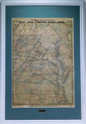 J. H. COLTON FOR WARREN HOLT
 VIRGINIA MARYLAND MAP California,1864J. H. Colton topographical map of Seat of War in Virginia, Maryland, & c. depicting a general map of eastern Virginia, Maryland, Delaware, southern Pennsylvania, and northern North Carolina.
J. H. COLTON FOR WARREN HOLT
J. H. COLTON FOR WARREN HOLT VIRGINIA MARYLAND MAP California,1864J. H. Colton topographical map of Seat of War in Virginia, Maryland, & c. depicting a general map of eastern Virginia, Maryland, Delaware, southern Pennsylvania, and northern North Carolina. -
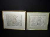 Pair 18th century New England /
 Massachusetts maps. Includes ''A Map of the Province of Massachusetts Bay and Colony of Rhode Island with part of Connecticut New Hampshire and Vermont.'' marked in lower margin ''London Publish'd as the act directs 15th of April 1782 by J Bew Pater Noster Row''. Also includes ''A New and accurate Map of the prefent Seat of War in North America from a late survey.'' no footnote. Both framed matted under glass and unexamined out of frame. Condition: creases to maps see images. Maps measure 15'' wide x 12'' tall. Frames measure 22'' wide and 21'' wide x 19'' tall and 18'' tall respectively. Shipping weight 7.7 lbs.
Pair 18th century New England /
Pair 18th century New England / Massachusetts maps. Includes ''A Map of the Province of Massachusetts Bay and Colony of Rhode Island with part of Connecticut New Hampshire and Vermont.'' marked in lower margin ''London Publish'd as the act directs 15th of April 1782 by J Bew Pater Noster Row''. Also includes ''A New and accurate Map of the prefent Seat of War in North America from a late survey.'' no footnote. Both framed matted under glass and unexamined out of frame. Condition: creases to maps see images. Maps measure 15'' wide x 12'' tall. Frames measure 22'' wide and 21'' wide x 19'' tall and 18'' tall respectively. Shipping weight 7.7 lbs. -
 Civil War-Era Maps Including
 Harper's Map of the Southern States Lot of 3 including:From Harper's Pictorial History of the Civil War the Map of the Southern States including Railroads County Towns State Capitals County Roads the Southern Coast from Delaware to Texas showing the Harbors Inlets Forts and Position of Blockading Ships. also featuring portraits of Lincoln Seward McClellan and Scott in the corners and with illustrated maps on verso Balloon View of Fortress Monroe and Hampton Roads Balloon View of the Seat of War and Pictorial Map of Portions of Delaware Maryland Virginia and North Carolina with the Coast Line From Camp Henry to Fort Pickens; 31.25 x 21 in.and two plates from the Atlas to Accompany the Official Records of the Union and Confederate Armies 1861-1865 including plate 28 showing the battlefields at Antietam Gettysburg Franklin and Suffolk and plate 166 Map of the United States of America showing the Boundaries of the Union and Confederate Geographical Divisions and Departments Dec. 31 1862. Condition: First with minor edge wear partial separation at folds reinforced with bookbinding tape on verso.? Second with minor separation at extreme top and bottom of center fold four stains in the lower margin and a crease at lower left.
Civil War-Era Maps Including
Civil War-Era Maps Including Harper's Map of the Southern States Lot of 3 including:From Harper's Pictorial History of the Civil War the Map of the Southern States including Railroads County Towns State Capitals County Roads the Southern Coast from Delaware to Texas showing the Harbors Inlets Forts and Position of Blockading Ships. also featuring portraits of Lincoln Seward McClellan and Scott in the corners and with illustrated maps on verso Balloon View of Fortress Monroe and Hampton Roads Balloon View of the Seat of War and Pictorial Map of Portions of Delaware Maryland Virginia and North Carolina with the Coast Line From Camp Henry to Fort Pickens; 31.25 x 21 in.and two plates from the Atlas to Accompany the Official Records of the Union and Confederate Armies 1861-1865 including plate 28 showing the battlefields at Antietam Gettysburg Franklin and Suffolk and plate 166 Map of the United States of America showing the Boundaries of the Union and Confederate Geographical Divisions and Departments Dec. 31 1862. Condition: First with minor edge wear partial separation at folds reinforced with bookbinding tape on verso.? Second with minor separation at extreme top and bottom of center fold four stains in the lower margin and a crease at lower left. -
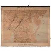 Rare Topographic Civil War Map
 Birds Eye View of Virginia Maryland Delaware and the District of Columbia 22 x 29.75 in. map mounted on linen and attached to wooden hanging bar. The title The Seat of War is printed in the upper margin and Birds Eye View of Virginia Delaware and the District of Columbia printed in lower margin. Undated but produced in 1861. Drawn and lithographed by J. Schedler and printed by Sarony Major & Knapp of New York. A rare and well-detailed map of the key theater of the early phase of the Civil War. The map includes street grids for Baltimore Washington Norfolk Richmond and Lynchburg. The map skillfully renders topography in particular the Blue Ridge Shenandoah and Allegheny Mountain ranges. It also offers fine detail throughout showing towns cities and river ways. In addition numerous steam-powered ships are shown traversing the waters of the Chesapeake Bay the Delaware Bay the Atlantic Ocean and the region's several navigable rivers. Condition: Condition of map is a bit rough overall; toning and soiling to map; wear along edges.
Rare Topographic Civil War Map
Rare Topographic Civil War Map Birds Eye View of Virginia Maryland Delaware and the District of Columbia 22 x 29.75 in. map mounted on linen and attached to wooden hanging bar. The title The Seat of War is printed in the upper margin and Birds Eye View of Virginia Delaware and the District of Columbia printed in lower margin. Undated but produced in 1861. Drawn and lithographed by J. Schedler and printed by Sarony Major & Knapp of New York. A rare and well-detailed map of the key theater of the early phase of the Civil War. The map includes street grids for Baltimore Washington Norfolk Richmond and Lynchburg. The map skillfully renders topography in particular the Blue Ridge Shenandoah and Allegheny Mountain ranges. It also offers fine detail throughout showing towns cities and river ways. In addition numerous steam-powered ships are shown traversing the waters of the Chesapeake Bay the Delaware Bay the Atlantic Ocean and the region's several navigable rivers. Condition: Condition of map is a bit rough overall; toning and soiling to map; wear along edges. -
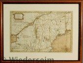 Framed and matted map of North
 America titled "A Map of that part of America which was the Principal Seat of War in 1756". 8.5"x13"
Framed and matted map of North
Framed and matted map of North America titled "A Map of that part of America which was the Principal Seat of War in 1756". 8.5"x13" -
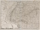 (MAP) KITCHEN THOMAS A group of two
 maps comprising Map of the Seat of War in Germany and A Map of the Seat of War in Italy accommodated to this History. 15 3/4 x 18 inches each.
(MAP) KITCHEN THOMAS A group of two
(MAP) KITCHEN THOMAS A group of two maps comprising Map of the Seat of War in Germany and A Map of the Seat of War in Italy accommodated to this History. 15 3/4 x 18 inches each. -
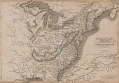
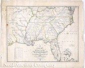 John Melish (Scottish/American
 1771-1822) "A Map of the Southern Section of the United States including the Floridas and Bahama Islands Shewing the Seat of War in that Department" drawn by John Melish engraved by H. S. Tanner hand-colored in outline Philadelphia 1813 from the rare Melish's Military & Topographical Atlas of the United States plate 17 in. x 21 in. sheet 19 1/2 in. x 24 in. unframed. Provenance: Estate of Alice Decatur Armsden and Douglas Armsden Kittery Point Maine. Reference: Walter W. Ristow American Maps and Mapmakers: Commercial Cartography in the Nineteenth Century Wayne State University Press Detroit 1985 pp. 180-183.
John Melish (Scottish/American
John Melish (Scottish/American 1771-1822) "A Map of the Southern Section of the United States including the Floridas and Bahama Islands Shewing the Seat of War in that Department" drawn by John Melish engraved by H. S. Tanner hand-colored in outline Philadelphia 1813 from the rare Melish's Military & Topographical Atlas of the United States plate 17 in. x 21 in. sheet 19 1/2 in. x 24 in. unframed. Provenance: Estate of Alice Decatur Armsden and Douglas Armsden Kittery Point Maine. Reference: Walter W. Ristow American Maps and Mapmakers: Commercial Cartography in the Nineteenth Century Wayne State University Press Detroit 1985 pp. 180-183. -
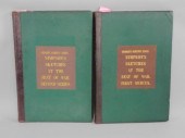
 Two volumes, William Johnson,
 Sketches of the Life and Correspondence of Nathaniel Greene, Major General of the Armies of the United States in the War of the Revolution, Charleston, South Carolina, printed by A.E. Miller, 1822, early tree calf, spines with gilt devices, Volume I, 515 pp. with frontispiece of Nathaniel Greene in full military attire engraved by J.H. Longacre from drawing by H. Bounetheau and marked "Presented by Congress, October 20, 1781", Volume II, 476 pp. with fold-out map, "The seat of War of the revolution in the Southern States; shewing [sic] the principal movements of the hostile armies", 19 x 14-1/2 in., 1 in. tear at hinge, both volumes with errata following numbered pages, each volume 11 x 9 in. Light to heavy foxing throughout, boards skinned, corners bumped with losses, spines with fading, normal tears and wear, scattered slight corner dents, stains. Private Collection, Greenville, South Carolina
Two volumes, William Johnson,
Two volumes, William Johnson, Sketches of the Life and Correspondence of Nathaniel Greene, Major General of the Armies of the United States in the War of the Revolution, Charleston, South Carolina, printed by A.E. Miller, 1822, early tree calf, spines with gilt devices, Volume I, 515 pp. with frontispiece of Nathaniel Greene in full military attire engraved by J.H. Longacre from drawing by H. Bounetheau and marked "Presented by Congress, October 20, 1781", Volume II, 476 pp. with fold-out map, "The seat of War of the revolution in the Southern States; shewing [sic] the principal movements of the hostile armies", 19 x 14-1/2 in., 1 in. tear at hinge, both volumes with errata following numbered pages, each volume 11 x 9 in. Light to heavy foxing throughout, boards skinned, corners bumped with losses, spines with fading, normal tears and wear, scattered slight corner dents, stains. Private Collection, Greenville, South Carolina
...many more examples with full details are available to our members - Learn more
Easy & Visual methods to Identify & Appraise Antiques & Collectibles
EASY. FAST. ACCURATE.
Research at its best
We are here to help!
Our research tools include:

Thousands of makers marks for PORCELAIN, POTTERY CHINAWARE, FIGURINES, VASES
see details...

Thousands of marks & hallmarks for SILVER & JEWELRY, PEWTER, PRECIOUS METALS, SILVERPLATE
see details...
