Pricing Guides & Dictionary of Makers Marks for Antiques & Collectibles
Appraise and find values for
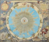
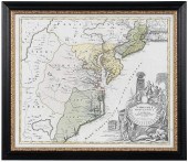
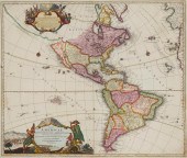
HOMANN - MAP OF MEXICO AND...
From
marks4antiques.com
- The most updated price guide and makers' marks research online
As a member, you have access to a team of experts
and assistance is always available to you for free
An example from the millions of items in our Price Guide:
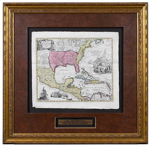
HOMANN - MAP OF MEXICO AND FLORIDAJohann Baptiste Homann, Regni Mexicani seu Novae Hispaniae, Floridae, Nova Angliae, Carolinae, Virginiae, et Pensylvaniae...
This is an example from our
values4antiques price guide
We do not buy or sell any items
See more price guides
Check our other research services:
IDENTIFY WORLDWIDE MAKERS' MARKS & HALLMARKS
marks4ceramics:
Porcelain, Pottery, Chinaware, Figurines, Dolls, Vases...
marks4silver
:
Silver, Jewelry, Pewter, Silverplate, Copper & Bronze...
Explore other items from our
Antiques & Collectibles Price Guide
-
 BRITANNIA, VOL. I & II CAMDEN 1722Camden
[more like this]
BRITANNIA, VOL. I & II CAMDEN 1722Camden
[more like this]
-
 AN ANTIQUE MAP, "TOTIUS AMERICAE SEPTENT
[more like this]
AN ANTIQUE MAP, "TOTIUS AMERICAE SEPTENT
[more like this]
-
 A COMPLETE SYSTEM OF GEOGRAPHY, VOL. I B
[more like this]
A COMPLETE SYSTEM OF GEOGRAPHY, VOL. I B
[more like this]
-
 IMPORTANT ANTIQUE ATLAS DU VOYAGE DE LA
[more like this]
IMPORTANT ANTIQUE ATLAS DU VOYAGE DE LA
[more like this]
-
 A LATE MEXICAN-AMERICAN WAR ERA MAP, "MA
[more like this]
A LATE MEXICAN-AMERICAN WAR ERA MAP, "MA
[more like this]
-
 5 KENTUCKY AND TENNESSEE MAPS1st item: "
[more like this]
5 KENTUCKY AND TENNESSEE MAPS1st item: "
[more like this]
-
 16TH / 18TH C. EUROPEAN MAPS OF NEW SPAI
[more like this]
16TH / 18TH C. EUROPEAN MAPS OF NEW SPAI
[more like this]
-
 3 KY & TN MAPS: VANCE, TANNER, JOHNSON1s
[more like this]
3 KY & TN MAPS: VANCE, TANNER, JOHNSON1s
[more like this]
-
 A RARE ANTIQUE CIVIL WAR ERA MAP, "PRESS
[more like this]
A RARE ANTIQUE CIVIL WAR ERA MAP, "PRESS
[more like this]
-
 4 TN & KY MAPS, 3 FRAMED1st item: "Tenne
[more like this]
4 TN & KY MAPS, 3 FRAMED1st item: "Tenne
[more like this]
-
 8 TENNESSEE MILITARY & SURVEY MAPSAssort
[more like this]
8 TENNESSEE MILITARY & SURVEY MAPSAssort
[more like this]
-
 A Very Large Collection of Maps, 19th/e
[more like this]
A Very Large Collection of Maps, 19th/e
[more like this]
-
 HOMANN HEIRS , AMERICAE: MAPPA GENERALIS
[more like this]
HOMANN HEIRS , AMERICAE: MAPPA GENERALIS
[more like this]
-
 A TOPOGRAPHICAL MAP OF THE ENVIRONS OF L
[more like this]
A TOPOGRAPHICAL MAP OF THE ENVIRONS OF L
[more like this]
-
 11 PC. MAP COLLECTION: Comprising; 1- La
[more like this]
11 PC. MAP COLLECTION: Comprising; 1- La
[more like this]
-
 3 19TH CENT. AL, KY, & TN MAPS1st item:
[more like this]
3 19TH CENT. AL, KY, & TN MAPS1st item:
[more like this]
-
 MAP AND ATLAS LOT, 3 PCS INCL. MELISH DI
[more like this]
MAP AND ATLAS LOT, 3 PCS INCL. MELISH DI
[more like this]
-
 AN IMPORTANT REPUBLIC OF TEXAS MAP, "MAP
[more like this]
AN IMPORTANT REPUBLIC OF TEXAS MAP, "MAP
[more like this]
-
 AN ANTIQUE RECONSTRUCTION ERA MAP, "KOSS
[more like this]
AN ANTIQUE RECONSTRUCTION ERA MAP, "KOSS
[more like this]
-
 5 CIVIL WAR MAPSLot of five Civil War ma
[more like this]
5 CIVIL WAR MAPSLot of five Civil War ma
[more like this]
-
 NATIVE AMERICAN/WESTERN U.S. EXPEDITION
[more like this]
NATIVE AMERICAN/WESTERN U.S. EXPEDITION
[more like this]
-
 AN ANTIQUE POCKET MAP, "MAP OF MEXICO AN
[more like this]
AN ANTIQUE POCKET MAP, "MAP OF MEXICO AN
[more like this]
-
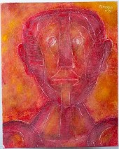 RUFINO TAMAYO MIXED MEDIA ON CANVAS BOAR
[more like this]
RUFINO TAMAYO MIXED MEDIA ON CANVAS BOAR
[more like this]
-
 AN ANTIQUE MAP, "SYSTEMA SOLARE ET PLANE
[more like this]
AN ANTIQUE MAP, "SYSTEMA SOLARE ET PLANE
[more like this]
-
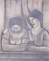 RUFINO TAMAYO "ESTUDIO" GRAPHITE ON PAPE
[more like this]
RUFINO TAMAYO "ESTUDIO" GRAPHITE ON PAPE
[more like this]
-
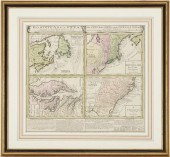 HOMANN MAP, BRITISH TERRITORIES IN NORTH
[more like this]
HOMANN MAP, BRITISH TERRITORIES IN NORTH
[more like this]
-
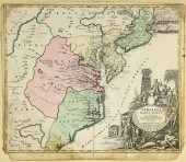
 HOMANN - MAP OF VIRGINIA, MARYLAND, AND
[more like this]
HOMANN - MAP OF VIRGINIA, MARYLAND, AND
[more like this]
-
 RARE 1865 MONTANA TERRITORY MAP BY W.W.
[more like this]
RARE 1865 MONTANA TERRITORY MAP BY W.W.
[more like this]
-
 4 EARLY AMERICAN MAPS: OVERTON, THIERRY,
[more like this]
4 EARLY AMERICAN MAPS: OVERTON, THIERRY,
[more like this]
-
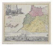 HOMANN ENGRAVING MAP MOROCCO NORTH AFRIC
[more like this]
HOMANN ENGRAVING MAP MOROCCO NORTH AFRIC
[more like this]
-
 JOHANN BAPTIST HOMANN MAP OF VIRGINIA, M
[more like this]
JOHANN BAPTIST HOMANN MAP OF VIRGINIA, M
[more like this]
-
 1720 HANDCOLORED HOMANN MAP TOTIUS AMERI
[more like this]
1720 HANDCOLORED HOMANN MAP TOTIUS AMERI
[more like this]
-
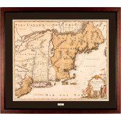 C 1730 HAND-COLORED MAP OF NEW ENGLAND T
[more like this]
C 1730 HAND-COLORED MAP OF NEW ENGLAND T
[more like this]
-
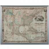 Colton's 1849 Map of the U.S. Showing Ca
[more like this]
Colton's 1849 Map of the U.S. Showing Ca
[more like this]
-
 JOHANNES BAPTIST HOMANN, (1663-1724), "T
[more like this]
JOHANNES BAPTIST HOMANN, (1663-1724), "T
[more like this]
-
 A RENAISSANCE MAP, "PTOLEMY MAP OF THE W
[more like this]
A RENAISSANCE MAP, "PTOLEMY MAP OF THE W
[more like this]
This list is limited to only a few results.
Many more items are available to our members in our
Price Guide!
Ideal research tools for Collectors, Personal Property Appraisers, Antiques & Collectibles
Dealers, Auction Houses, Museums, eBayers or
other online
sellers (Rubylane, Etsy etc) and curious minds interested in appraising & identifying collectibles

EASY. FAST. ACCURATE.
Research at its best

Our research tools include:


