Pricing Guides & Dictionary of Makers Marks for Antiques & Collectibles
Appraise and find values for
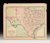
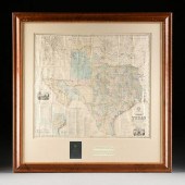
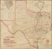
WARNER & BEERS, "MAP OF TEXAS,"...
From
marks4antiques.com
- The most updated price guide and makers' marks research online
As a member, you have access to a team of experts
and assistance is always available to you for free
An example from the millions of items in our Price Guide:
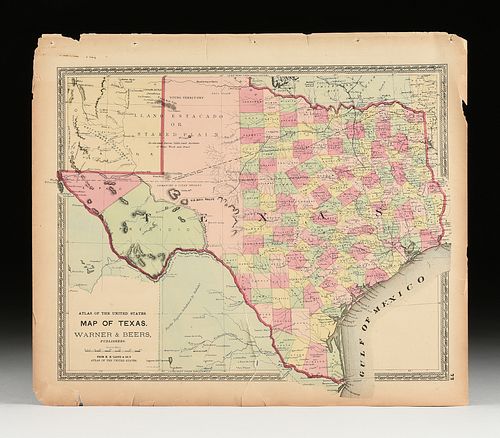
WARNER & BEERS, "MAP OF TEXAS," FROM H.H. LLOYD & CO.'S...WARNER & BEERS, "Map of Texas," FROM H.H. LLOYD & CO.'S ATLAS OF THE UNITED STATES, 1870s,...
This is an example from our
values4antiques price guide
We do not buy or sell any items
See more price guides
Check our other research services:
IDENTIFY WORLDWIDE MAKERS' MARKS & HALLMARKS
marks4ceramics:
Porcelain, Pottery, Chinaware, Figurines, Dolls, Vases...
marks4silver
:
Silver, Jewelry, Pewter, Silverplate, Copper & Bronze...
Explore other items from our
Antiques & Collectibles Price Guide
-
 BRITANNIA, VOL. I & II CAMDEN 1722Camden
[more like this]
BRITANNIA, VOL. I & II CAMDEN 1722Camden
[more like this]
-
 GROUP OF 31 1930S - 50S INSERT-SIZED MOV
[more like this]
GROUP OF 31 1930S - 50S INSERT-SIZED MOV
[more like this]
-
 A COMPLETE SYSTEM OF GEOGRAPHY, VOL. I B
[more like this]
A COMPLETE SYSTEM OF GEOGRAPHY, VOL. I B
[more like this]
-
 IMPORTANT ANTIQUE ATLAS DU VOYAGE DE LA
[more like this]
IMPORTANT ANTIQUE ATLAS DU VOYAGE DE LA
[more like this]
-
 A RARE ANTIQUE CIVIL WAR ERA MAP, "PRESS
[more like this]
A RARE ANTIQUE CIVIL WAR ERA MAP, "PRESS
[more like this]
-
 GROUP OF 19 1930S - 40S MOVIE WINDOW CAR
[more like this]
GROUP OF 19 1930S - 40S MOVIE WINDOW CAR
[more like this]
-
 5 KENTUCKY AND TENNESSEE MAPS1st item: "
[more like this]
5 KENTUCKY AND TENNESSEE MAPS1st item: "
[more like this]
-
 3 KY & TN MAPS: VANCE, TANNER, JOHNSON1s
[more like this]
3 KY & TN MAPS: VANCE, TANNER, JOHNSON1s
[more like this]
-
 AN ANTEBELLUM MAP, "J. DE CORDOVA'S MAP
[more like this]
AN ANTEBELLUM MAP, "J. DE CORDOVA'S MAP
[more like this]
-
 A Group of Twelve Maps of Illinois
compr
[more like this]
A Group of Twelve Maps of Illinois
compr
[more like this]
-
 4 TN & KY MAPS, 3 FRAMED1st item: "Tenne
[more like this]
4 TN & KY MAPS, 3 FRAMED1st item: "Tenne
[more like this]
-
 19TH C. US GLASS BOTTLES - CARTER'S INK
[more like this]
19TH C. US GLASS BOTTLES - CARTER'S INK
[more like this]
-
 (15) TEXAS HISTORICAL REFERENCE BOOKS, L
[more like this]
(15) TEXAS HISTORICAL REFERENCE BOOKS, L
[more like this]
-
 (42) TEXANA RELATED BOOKS & PAMPHLETS(lo
[more like this]
(42) TEXANA RELATED BOOKS & PAMPHLETS(lo
[more like this]
-
 JULIE H. BEERS HUDSON RIVER SCHOOL O/C P
[more like this]
JULIE H. BEERS HUDSON RIVER SCHOOL O/C P
[more like this]
-
 A Very Large Collection of Maps, 19th/e
[more like this]
A Very Large Collection of Maps, 19th/e
[more like this]
-
 8 TENNESSEE MILITARY & SURVEY MAPSAssort
[more like this]
8 TENNESSEE MILITARY & SURVEY MAPSAssort
[more like this]
-
 AN ANTIQUE REPUBLIC OF TEXAS MAP, "MAP O
[more like this]
AN ANTIQUE REPUBLIC OF TEXAS MAP, "MAP O
[more like this]
-
 16TH / 18TH C. EUROPEAN MAPS OF NEW SPAI
[more like this]
16TH / 18TH C. EUROPEAN MAPS OF NEW SPAI
[more like this]
-
 AN ANTIQUE RECONSTRUCTION ERA MAP, "TRAV
[more like this]
AN ANTIQUE RECONSTRUCTION ERA MAP, "TRAV
[more like this]
-
 A TOPOGRAPHICAL MAP OF THE ENVIRONS OF L
[more like this]
A TOPOGRAPHICAL MAP OF THE ENVIRONS OF L
[more like this]
-
 11 PC. MAP COLLECTION: Comprising; 1- La
[more like this]
11 PC. MAP COLLECTION: Comprising; 1- La
[more like this]
-
 WARNER & BEERS, "MAP OF TEXAS," FROM H.H
[more like this]
WARNER & BEERS, "MAP OF TEXAS," FROM H.H
[more like this]
-
 (15) BOOKS: TEXAS FICTION, HISTORY, PHOT
[more like this]
(15) BOOKS: TEXAS FICTION, HISTORY, PHOT
[more like this]
-
 (19) BOOKS, TEXAS SUBJECTS & MORE, M
[more like this]
(19) BOOKS, TEXAS SUBJECTS & MORE, M
[more like this]
-
 AN ANTIQUE MAP, "A.R. ROESSLER'S LATEST
[more like this]
AN ANTIQUE MAP, "A.R. ROESSLER'S LATEST
[more like this]
-
 TWO ANTIQUE ANTEBELLUM MAPS, "MAP OF TEX
[more like this]
TWO ANTIQUE ANTEBELLUM MAPS, "MAP OF TEX
[more like this]
-
 A LATE MEXICAN-AMERICAN WAR ERA MAP, "MA
[more like this]
A LATE MEXICAN-AMERICAN WAR ERA MAP, "MA
[more like this]
-
 AN IMPORTANT REPUBLIC OF TEXAS MAP, "MAP
[more like this]
AN IMPORTANT REPUBLIC OF TEXAS MAP, "MAP
[more like this]
-
 AN ANTIQUE RECONSTRUCTION ERA MAP, "KOSS
[more like this]
AN ANTIQUE RECONSTRUCTION ERA MAP, "KOSS
[more like this]
-
 3 19TH CENT. AL, KY, & TN MAPS1st item:
[more like this]
3 19TH CENT. AL, KY, & TN MAPS1st item:
[more like this]
-
 MAP AND ATLAS LOT, 3 PCS INCL. MELISH DI
[more like this]
MAP AND ATLAS LOT, 3 PCS INCL. MELISH DI
[more like this]
-
 5 CIVIL WAR MAPSLot of five Civil War ma
[more like this]
5 CIVIL WAR MAPSLot of five Civil War ma
[more like this]
-
 NATIVE AMERICAN/WESTERN U.S. EXPEDITION
[more like this]
NATIVE AMERICAN/WESTERN U.S. EXPEDITION
[more like this]
-
 AN ANTIQUE MAP, "MK & T RAILWAY SECTIONA
[more like this]
AN ANTIQUE MAP, "MK & T RAILWAY SECTIONA
[more like this]
-
 NAVAL ELECTRIC CO. BRASS U.S. NAVY SIGNA
[more like this]
NAVAL ELECTRIC CO. BRASS U.S. NAVY SIGNA
[more like this]
This list is limited to only a few results.
Many more items are available to our members in our
Price Guide!
Ideal research tools for Collectors, Personal Property Appraisers, Antiques & Collectibles
Dealers, Auction Houses, Museums, eBayers or
other online
sellers (Rubylane, Etsy etc) and curious minds interested in appraising & identifying collectibles

EASY. FAST. ACCURATE.
Research at its best

Our research tools include:


