Pricing Guides & Dictionary of Makers Marks for Antiques & Collectibles
A few examples of appraisal values for
1466
Search our price guide for your own treasures
-
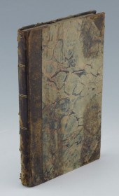
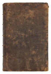 1676 VOLUME "THE ANNALS OF
 ENGLAND ..."1676 VOLUME "THE ANNALS OF ENGLAND ...", By Francis Bacon, Francis Goodwin and Morgan Goodwin. Fully titled The History of the Reigns of Henry the Seventh, Henry the Eighth, Edward the Sixth, and Queen Mary,. London: W.G. for R. Scot, et al, 1676. Leather. Quarto (11.75" x 8"). 201pp.
1676 VOLUME "THE ANNALS OF
1676 VOLUME "THE ANNALS OF ENGLAND ..."1676 VOLUME "THE ANNALS OF ENGLAND ...", By Francis Bacon, Francis Goodwin and Morgan Goodwin. Fully titled The History of the Reigns of Henry the Seventh, Henry the Eighth, Edward the Sixth, and Queen Mary,. London: W.G. for R. Scot, et al, 1676. Leather. Quarto (11.75" x 8"). 201pp. -
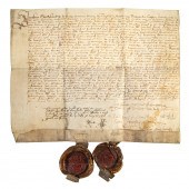
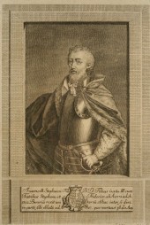
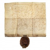 SCOTTISH RENAISSANCE DOCUMENT, 1572
 James Sandiland (c.1511-1579, sometime Grand Master of the Knights Hospitaller, 1st Lord Torphichen) original manuscript document in Latin and English, June 3, 1572, to John Browne, with a large seal affixed; faintly endorsed verso; 1 p., on vellum, 8 x 9 1/2 in.
SCOTTISH RENAISSANCE DOCUMENT, 1572
SCOTTISH RENAISSANCE DOCUMENT, 1572 James Sandiland (c.1511-1579, sometime Grand Master of the Knights Hospitaller, 1st Lord Torphichen) original manuscript document in Latin and English, June 3, 1572, to John Browne, with a large seal affixed; faintly endorsed verso; 1 p., on vellum, 8 x 9 1/2 in. -
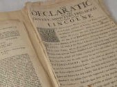
 1766 LONDON CHRONICLE
 NEWSPAPERFascinating early example. Dated April 24, 1766. shipping info This item can be shipped in-house.
1766 LONDON CHRONICLE
1766 LONDON CHRONICLE NEWSPAPERFascinating early example. Dated April 24, 1766. shipping info This item can be shipped in-house. -
 A number of historic
 proclamations and other documents of the years 1659 to 1715 including the taking and subsequent execution of Lord Monmouth after the rebellion of 1685 proclamations after the treaty of Breda 1667 details of the court which sentenced Charles I in 1648 and a later court sentencing after the Jacobite rebellion in 1715.
A number of historic
A number of historic proclamations and other documents of the years 1659 to 1715 including the taking and subsequent execution of Lord Monmouth after the rebellion of 1685 proclamations after the treaty of Breda 1667 details of the court which sentenced Charles I in 1648 and a later court sentencing after the Jacobite rebellion in 1715. -
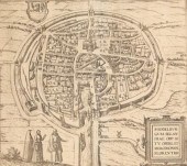
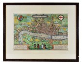 LODINUM FERACISSIMI ANGLIAE REGNI
 METROPOLIS MAPGeorge Braun and Franz Hogenberg, Published, Cologne, 1579, engraved by Hoefnagel, with four figures in foreground, a decorative cartouche, the arms of Queen Elizabeth displayed in the top left hand corner, with the arms of the City on the right, text in Latin on the reverse. Hand colored later, framed, mounted with conservation back for viewing. Site measurement 12.25 in by 18.5 in.
LODINUM FERACISSIMI ANGLIAE REGNI
LODINUM FERACISSIMI ANGLIAE REGNI METROPOLIS MAPGeorge Braun and Franz Hogenberg, Published, Cologne, 1579, engraved by Hoefnagel, with four figures in foreground, a decorative cartouche, the arms of Queen Elizabeth displayed in the top left hand corner, with the arms of the City on the right, text in Latin on the reverse. Hand colored later, framed, mounted with conservation back for viewing. Site measurement 12.25 in by 18.5 in. -
 SCOTTISH RENAISSANCE DOCUMENT, 1582
 Original manuscript document in Latin and English, January 23, 1582, pertaining to the guardianship and instruction of James Sandilands of Calder, 2nd Lord Torphichen (1576-1617, then a minor), witnessed and signed by 5 unidentified individuals, with two large seals affixed; endorsed, "Preceptum caisma et Joann. Cokburn de ormistom;" 1 p., on vellum, 9 3/4 x 12 1/2 in.
SCOTTISH RENAISSANCE DOCUMENT, 1582
SCOTTISH RENAISSANCE DOCUMENT, 1582 Original manuscript document in Latin and English, January 23, 1582, pertaining to the guardianship and instruction of James Sandilands of Calder, 2nd Lord Torphichen (1576-1617, then a minor), witnessed and signed by 5 unidentified individuals, with two large seals affixed; endorsed, "Preceptum caisma et Joann. Cokburn de ormistom;" 1 p., on vellum, 9 3/4 x 12 1/2 in. -
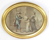 A Molteno Edward IV being
 introduced to Jane Shore stipple engraving
A Molteno Edward IV being
A Molteno Edward IV being introduced to Jane Shore stipple engraving -
 A quantity of historic documents
 and ephemera including a document dated 1480 documents of the 16th and 17th century several Acts of Parliament of William III George II etc. 17/18th loan and payment documents including dated 1691 for services in Ireland dated 1710 signed Walpole dated 1729 signed Marlborough and Godolphin books of verses etc.
A quantity of historic documents
A quantity of historic documents and ephemera including a document dated 1480 documents of the 16th and 17th century several Acts of Parliament of William III George II etc. 17/18th loan and payment documents including dated 1691 for services in Ireland dated 1710 signed Walpole dated 1729 signed Marlborough and Godolphin books of verses etc. -
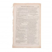 PAGE 465, 466 FROM AN EARLY EDITION
 OF KING HENRY VI BY WILLIAM SHAKESPEARE; ANTIQUARIAN THEATRICAL TEXT. 13 1/8"H X 8 1/4"WPage 465, 466 from an early edition of King Henry VI by William Shakespeare; antiquarian theatrical text., Pencil notation upper left; 3 and 86b. Dimensions: 13 1/8"H x 8 1/4"W
PAGE 465, 466 FROM AN EARLY EDITION
PAGE 465, 466 FROM AN EARLY EDITION OF KING HENRY VI BY WILLIAM SHAKESPEARE; ANTIQUARIAN THEATRICAL TEXT. 13 1/8"H X 8 1/4"WPage 465, 466 from an early edition of King Henry VI by William Shakespeare; antiquarian theatrical text., Pencil notation upper left; 3 and 86b. Dimensions: 13 1/8"H x 8 1/4"W -
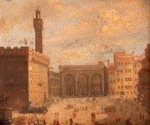 English School, circa 1840/Piazza
 della Signoria/Piazza San Lorenzo/a pair/oil on paper, 11.5cm x 13.5cm
English School, circa 1840/Piazza
English School, circa 1840/Piazza della Signoria/Piazza San Lorenzo/a pair/oil on paper, 11.5cm x 13.5cm -
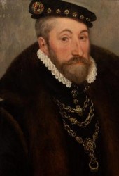 English School, 16th
 Century/Portrait of a Nobleman/possibly Sir Henry Bedingfeld of Oxburgh Hall, Norfolk/half-length, wearing a black doublet and fur trimmed coat, a jewelled black cap and ornate gold chains suspending a seal fob/inscribed upper left An Dn 1566 and upper right Aeta Sua 51/oil on panel, 45.5cm x 31cm, laid on a modern linen backed wood panel/Provenance: from the collection of Harry Wolton QC
English School, 16th
English School, 16th Century/Portrait of a Nobleman/possibly Sir Henry Bedingfeld of Oxburgh Hall, Norfolk/half-length, wearing a black doublet and fur trimmed coat, a jewelled black cap and ornate gold chains suspending a seal fob/inscribed upper left An Dn 1566 and upper right Aeta Sua 51/oil on panel, 45.5cm x 31cm, laid on a modern linen backed wood panel/Provenance: from the collection of Harry Wolton QC -
 Portraits of Kings, 1620: Martini
 Hamconii Frisia Sev De Viris Rebusque, Joannis Starteri (Bibliopolae Sumptibus), 1620, each page with prints of various kings, many in military pose and brandishing weapons, quarter calf over marbled boards, 9 x 7 in. Pages remounted, binding with extensive spine losses, hinges weak.
Portraits of Kings, 1620: Martini
Portraits of Kings, 1620: Martini Hamconii Frisia Sev De Viris Rebusque, Joannis Starteri (Bibliopolae Sumptibus), 1620, each page with prints of various kings, many in military pose and brandishing weapons, quarter calf over marbled boards, 9 x 7 in. Pages remounted, binding with extensive spine losses, hinges weak. -
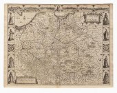 John Speed map of Poland, 1626,
 "A Newe Mape of Poland, Done into English by J. Speede" [sic], engraved by Dirck Gryp, published by George Humble, London, 1626, eight vignettes of costumed figures at sides and six city views at top, on laid paper with English text verso, 16-1/2 x 21-1/2 in. Loose, toning, minor foxing, stains, smudges, reinforced center crease with some darkening, upper margin trimmed including plate mark.
John Speed map of Poland, 1626,
John Speed map of Poland, 1626, "A Newe Mape of Poland, Done into English by J. Speede" [sic], engraved by Dirck Gryp, published by George Humble, London, 1626, eight vignettes of costumed figures at sides and six city views at top, on laid paper with English text verso, 16-1/2 x 21-1/2 in. Loose, toning, minor foxing, stains, smudges, reinforced center crease with some darkening, upper margin trimmed including plate mark. -
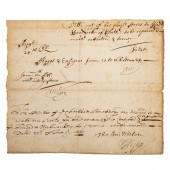 SAMUEL PEPYS, DS, 1668 Samuel Pepys
 (1633-1703, Secretary of the Admiralty, diarist) handwritten document, signed, dated February 20, 1668; 1 p., 8vo, 6 1/2 x 7 5/8 in.; an order for the "widow woodcock" of Chatham to repair various flags and ensigns, "being much ratteaten & torne," and that she be given clear instructions concerning thread and workmanship; signed by Pepys, l.r. and possibly endorsed in his hand; also signed by Col. Thomas Middleton, Surveyor of the Navy, and Tom Wilson, a secretary.
SAMUEL PEPYS, DS, 1668 Samuel Pepys
SAMUEL PEPYS, DS, 1668 Samuel Pepys (1633-1703, Secretary of the Admiralty, diarist) handwritten document, signed, dated February 20, 1668; 1 p., 8vo, 6 1/2 x 7 5/8 in.; an order for the "widow woodcock" of Chatham to repair various flags and ensigns, "being much ratteaten & torne," and that she be given clear instructions concerning thread and workmanship; signed by Pepys, l.r. and possibly endorsed in his hand; also signed by Col. Thomas Middleton, Surveyor of the Navy, and Tom Wilson, a secretary. -
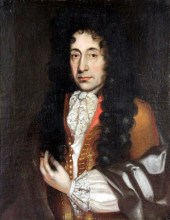
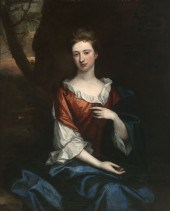 Sir Godfrey Kneller (1646-1723
 British) Portrait of a Lady in a Red Dress with Blue Mantle in a Rocky Landscape
Sir Godfrey Kneller (1646-1723
Sir Godfrey Kneller (1646-1723 British) Portrait of a Lady in a Red Dress with Blue Mantle in a Rocky Landscape -
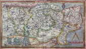
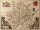
 Christopher Saxton
 (1540-1610)/Oxfordshire, Berkshire and Buckinghamshire/colour print, 39.5cm x 46cm
Christopher Saxton
Christopher Saxton (1540-1610)/Oxfordshire, Berkshire and Buckinghamshire/colour print, 39.5cm x 46cm -
 Dated 1904
Dated 1904
Dated 1904 -
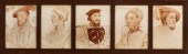 After Hans Holbein the Younger
 (1497/98-1543) Two sets of framed sanguine lithograph portraits of luminaries of the Tudor Court, first quarter 20th century, presented in period reeded oak frames in the Arts and Crafts style and glazed, one with twelve sections including, Edward, Prince of Wales, Lord Russell, Keeper of the Privy Seal, Waramus, Archbishop of Canterbury, Fitz William, the Earl of Southampton, Edward Stanley, the Earl of Darby, Sir Henry Guhldeford, S. George of Cromwell, Southwell Knight, et al., h. 12", w. 106", the other with sections including the Marquis of Ormond, Queen Anna Bollein, the Duchess of Suffolk and a male courtier in a plumed hat, h. 12-1/2", w. 42".
After Hans Holbein the Younger
After Hans Holbein the Younger (1497/98-1543) Two sets of framed sanguine lithograph portraits of luminaries of the Tudor Court, first quarter 20th century, presented in period reeded oak frames in the Arts and Crafts style and glazed, one with twelve sections including, Edward, Prince of Wales, Lord Russell, Keeper of the Privy Seal, Waramus, Archbishop of Canterbury, Fitz William, the Earl of Southampton, Edward Stanley, the Earl of Darby, Sir Henry Guhldeford, S. George of Cromwell, Southwell Knight, et al., h. 12", w. 106", the other with sections including the Marquis of Ormond, Queen Anna Bollein, the Duchess of Suffolk and a male courtier in a plumed hat, h. 12-1/2", w. 42". -
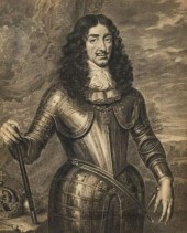 RARE ENGRAVING, KING CHARLES II,
 CIRCA 1666Cornelis van Dalen the younger (1638-1664), after Pieter Nason (1612-1688), King Charles II (1630-1685), an exceptionally rare line engraving, circa 1666. With a letter from the Department of Prints & Drawings, British Museum dated 1934 accompanies this lot. Measuring, 15.5" x 11.25". Note: events that took place at the time this engraving was created: The Convention Parliament & Lords proclaim Charles II King after he issues a declaration from Breda offering an indemnity to those who had committed crimes against the crown during the civil war and Interregnum. Charles lands at Dover from The Hague on 25th May to great pomp and ceremony. Dutch portrait painter, Peter Lely, is appointed principal painter to Charles II. Official foundation of the Royal Society. The Anglo-Spanish War, begun by Lord Protector, Oliver Cromwell, formally ends after the restoration of the British monarchy and peace is made with Philip IV of Spain.
RARE ENGRAVING, KING CHARLES II,
RARE ENGRAVING, KING CHARLES II, CIRCA 1666Cornelis van Dalen the younger (1638-1664), after Pieter Nason (1612-1688), King Charles II (1630-1685), an exceptionally rare line engraving, circa 1666. With a letter from the Department of Prints & Drawings, British Museum dated 1934 accompanies this lot. Measuring, 15.5" x 11.25". Note: events that took place at the time this engraving was created: The Convention Parliament & Lords proclaim Charles II King after he issues a declaration from Breda offering an indemnity to those who had committed crimes against the crown during the civil war and Interregnum. Charles lands at Dover from The Hague on 25th May to great pomp and ceremony. Dutch portrait painter, Peter Lely, is appointed principal painter to Charles II. Official foundation of the Royal Society. The Anglo-Spanish War, begun by Lord Protector, Oliver Cromwell, formally ends after the restoration of the British monarchy and peace is made with Philip IV of Spain. -
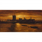 D. Smyth LONDON PARLIAMENT, 1966
 signed and dated lower right 16 x 30 in — 40.6 x 76.2 cm
D. Smyth LONDON PARLIAMENT, 1966
D. Smyth LONDON PARLIAMENT, 1966 signed and dated lower right 16 x 30 in — 40.6 x 76.2 cm -
 QUEEN ELIZABETH'S PRIVY COUNCIL
 SIGNATURES, 1560 Fragment of an official letter of the Privy Council, dated February 29, 1560, bearing the signatures of Sir Nicholas Bacon, Keeper of the Great Seal; Francis Russell, 2nd Earl of Bedford; Sir William Herbert, 1st Earl of Pembroke; and Edward Clinton, 1st Earl of Lincoln and Lord High Admiral of the Navy; 4 1/4 x 6 in.
QUEEN ELIZABETH'S PRIVY COUNCIL
QUEEN ELIZABETH'S PRIVY COUNCIL SIGNATURES, 1560 Fragment of an official letter of the Privy Council, dated February 29, 1560, bearing the signatures of Sir Nicholas Bacon, Keeper of the Great Seal; Francis Russell, 2nd Earl of Bedford; Sir William Herbert, 1st Earl of Pembroke; and Edward Clinton, 1st Earl of Lincoln and Lord High Admiral of the Navy; 4 1/4 x 6 in. -
 ENGRAVING - 16th Century German
 depicting King John II of Bavaria son of Stephen I of Wittelsbach 1375-1397 Duke of Bavaria-Munich by G. A. Zimermann after Werner shrink-wrapped plate size: 11'' x 7 1/2'' foxing. Image is quite sharp.
ENGRAVING - 16th Century German
ENGRAVING - 16th Century German depicting King John II of Bavaria son of Stephen I of Wittelsbach 1375-1397 Duke of Bavaria-Munich by G. A. Zimermann after Werner shrink-wrapped plate size: 11'' x 7 1/2'' foxing. Image is quite sharp. -
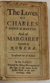 17C. GREGORIO LETI LOVES OF DUKE
 CHARLES England, Italy,1630-1701, Circa 1669Antiquarian leather bound book, "The Loves of Charles Duke of Mantua: And of Margaret Countess of Rovera", translated from Italian, printed for Henry Herringman at the Sign of the Anchor in the Lower-Walk of the New-Exchange, 1669. Book with inscription on verso of frontispiece.
17C. GREGORIO LETI LOVES OF DUKE
17C. GREGORIO LETI LOVES OF DUKE CHARLES England, Italy,1630-1701, Circa 1669Antiquarian leather bound book, "The Loves of Charles Duke of Mantua: And of Margaret Countess of Rovera", translated from Italian, printed for Henry Herringman at the Sign of the Anchor in the Lower-Walk of the New-Exchange, 1669. Book with inscription on verso of frontispiece. -
 Wycliffe Eggington (1875-1951). A
 large watercolour of a distant view of a castle monogram WE bottom right. 98 x 65 cm.
Wycliffe Eggington (1875-1951). A
Wycliffe Eggington (1875-1951). A large watercolour of a distant view of a castle monogram WE bottom right. 98 x 65 cm. -
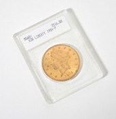
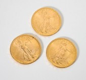 Each dated 1916-S
Each dated 1916-S
Each dated 1916-S -
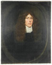 17th Century English
 School/Portrait of a Gentleman/half-length wearing a brown coat/dated An Domn 1663/oil on canvas 76cm x 61cm (30" x 24") unframed
17th Century English
17th Century English School/Portrait of a Gentleman/half-length wearing a brown coat/dated An Domn 1663/oil on canvas 76cm x 61cm (30" x 24") unframed -
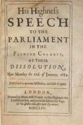 1 vol. English Commonwealth Period
 Imprints: (Cromwell, Oliver.) His Highness Speech to The Parliament in The Painted Chamber, at Their Dissolution,... January, 1654. London: Henry Hills, 1654[5]. Sm. 4to, 19th-Century 1/2 calf & marbled bds.; scuffed, joints & extremities rubbed. Some internal dampstaining. Wing C-7170D. Bound with: (_ _.) A Declaration of His Highness by The Advice of Council,... Reasons... Securing The Peace of The Commonwealth... London: Henry Hills and John Field, 1655. Sm. 4to. Some internal dampstaining. Thomason E-1065[1]. Also bound with: Fiennes, Lord Nathaniel. The Speech of... Made before his Highnesse and both Houses of Parliament:... 27th of January, 1658. 4to. Some dampstaining. All trimmed - a few heads shaved close. Wing F-.
1 vol. English Commonwealth Period
1 vol. English Commonwealth Period Imprints: (Cromwell, Oliver.) His Highness Speech to The Parliament in The Painted Chamber, at Their Dissolution,... January, 1654. London: Henry Hills, 1654[5]. Sm. 4to, 19th-Century 1/2 calf & marbled bds.; scuffed, joints & extremities rubbed. Some internal dampstaining. Wing C-7170D. Bound with: (_ _.) A Declaration of His Highness by The Advice of Council,... Reasons... Securing The Peace of The Commonwealth... London: Henry Hills and John Field, 1655. Sm. 4to. Some internal dampstaining. Thomason E-1065[1]. Also bound with: Fiennes, Lord Nathaniel. The Speech of... Made before his Highnesse and both Houses of Parliament:... 27th of January, 1658. 4to. Some dampstaining. All trimmed - a few heads shaved close. Wing F-. -
 1726 ENGLISH RELIGIOUS BOOK: Titled
 '' A Treatise on the Religouse Observation of the Lords-Day According to the Express Words of the Fourth Commandment'' Third Edition printed for J. clark and R. Hett oat the bible and Crown in the Poultry; and E. Matthews at the Bible in Paternoster-Row 1726. 1/2 leather with marble boards. 7 1/2'' x 5 3/4''.CONDITION: Note staining and wear to cover foxing and water marks to pages.
1726 ENGLISH RELIGIOUS BOOK: Titled
1726 ENGLISH RELIGIOUS BOOK: Titled '' A Treatise on the Religouse Observation of the Lords-Day According to the Express Words of the Fourth Commandment'' Third Edition printed for J. clark and R. Hett oat the bible and Crown in the Poultry; and E. Matthews at the Bible in Paternoster-Row 1726. 1/2 leather with marble boards. 7 1/2'' x 5 3/4''.CONDITION: Note staining and wear to cover foxing and water marks to pages. -
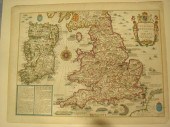
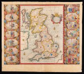 JAN JANSSON MAP OF BRITANNIAJan
 Jansson Map of Britannia , "Britannis Prout Divisa fuit Temporibus Anglo-Saxonum, Praesertim Durante Illorum Heptarchia", Amsterdam, c. 1646, hand-colored engraving, Anglo-Saxon map, with vignettes of the kings of the 5th-7th centuries
JAN JANSSON MAP OF BRITANNIAJan
JAN JANSSON MAP OF BRITANNIAJan Jansson Map of Britannia , "Britannis Prout Divisa fuit Temporibus Anglo-Saxonum, Praesertim Durante Illorum Heptarchia", Amsterdam, c. 1646, hand-colored engraving, Anglo-Saxon map, with vignettes of the kings of the 5th-7th centuries -
 George Braun (1541-1622) and
 Franz Hogenberg (c.1538-1590)/Middelburgum Selandiae Opp Situ Opere at Mercimonis Florentiss/black and white engraved map from 'Civitates Orbis Terrarum', 40.5cm x 51cm
George Braun (1541-1622) and
George Braun (1541-1622) and Franz Hogenberg (c.1538-1590)/Middelburgum Selandiae Opp Situ Opere at Mercimonis Florentiss/black and white engraved map from 'Civitates Orbis Terrarum', 40.5cm x 51cm -
 A late 16th/early 17th Century
 coloured engraving - ''Map of the Shyre of Kent divided into five lathes therof'' - Map of Kent showing London part of Surrey and Sussex 7.75ins x 14.25ins (Anonymous - thought to be the second state of the first separate printed map of Kent which was first published circa 1580. This example is probably issued circa 1625) in modern gilt moulded frame and glazed Provenance : O'Shea Gallery 89 Lower Sloane Street London SW1W 8DA
A late 16th/early 17th Century
A late 16th/early 17th Century coloured engraving - ''Map of the Shyre of Kent divided into five lathes therof'' - Map of Kent showing London part of Surrey and Sussex 7.75ins x 14.25ins (Anonymous - thought to be the second state of the first separate printed map of Kent which was first published circa 1580. This example is probably issued circa 1625) in modern gilt moulded frame and glazed Provenance : O'Shea Gallery 89 Lower Sloane Street London SW1W 8DA -
 late 17th Century English
 SchoolPortrait of a Gentlemanwearing a lace jacket and a gold coloured coatoil on canvas 71.5cm x 56cm (28" x 22")
late 17th Century English
late 17th Century English SchoolPortrait of a Gentlemanwearing a lace jacket and a gold coloured coatoil on canvas 71.5cm x 56cm (28" x 22") -
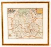
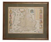 CHRISTOPHER SAXTON (1540-1610)
 AND JOHN SPEED (1552-1629), THE KINGDOME OF ENGLAND coloured engraving, 39cm x 51cm, published by Abraham Goos, 1646, in later gilt frame and glazed
CHRISTOPHER SAXTON (1540-1610)
CHRISTOPHER SAXTON (1540-1610) AND JOHN SPEED (1552-1629), THE KINGDOME OF ENGLAND coloured engraving, 39cm x 51cm, published by Abraham Goos, 1646, in later gilt frame and glazed -
 Johannes Blaeu/Monumethensis
 Comitatus Vernacule Monmouth Shire/Amsterdam, circa 1645/engraved map with hand colouring, large decorative cartouche and mileage scale, 38cm x 50cm and/Comitatus Dorcestria sive Dorsettia; vulgo Anglice Dorset Shire/circa 1660/engraved map with hand colouring, large ornate cartouche, 38.5cm x 50cm (2) Provenance: Sotheby's 7th April 1998, Lot 212 (part)
Johannes Blaeu/Monumethensis
Johannes Blaeu/Monumethensis Comitatus Vernacule Monmouth Shire/Amsterdam, circa 1645/engraved map with hand colouring, large decorative cartouche and mileage scale, 38cm x 50cm and/Comitatus Dorcestria sive Dorsettia; vulgo Anglice Dorset Shire/circa 1660/engraved map with hand colouring, large ornate cartouche, 38.5cm x 50cm (2) Provenance: Sotheby's 7th April 1998, Lot 212 (part) -
 John Speed, 1627, The Invasions
 of England and Ireland With Al their Civill Wars Since the Conquest", a Historical map of England, Wales and Ireland "Are to be solde by Thomas Basset in Fleet Street and Richard Chiswell in Churchyard", image 15" x 20 1/2", text on both leaves verso, a highly decorative detailed map, superbly engraved by Cornelius Danckertsz, The map shows the various invasions and internal battles from the Norman invasion in 1066 to 1588. The land battles are marked by opposing phalanxes of troops, the invasion places from Sea by attacking fleets Estimate $800-1,200
John Speed, 1627, The Invasions
John Speed, 1627, The Invasions of England and Ireland With Al their Civill Wars Since the Conquest", a Historical map of England, Wales and Ireland "Are to be solde by Thomas Basset in Fleet Street and Richard Chiswell in Churchyard", image 15" x 20 1/2", text on both leaves verso, a highly decorative detailed map, superbly engraved by Cornelius Danckertsz, The map shows the various invasions and internal battles from the Norman invasion in 1066 to 1588. The land battles are marked by opposing phalanxes of troops, the invasion places from Sea by attacking fleets Estimate $800-1,200 -
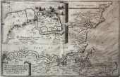 Matthaus Merian (1621-1687) -
 Engraving - ''Rivier Oder Gegent Von London'' - An unusual map of the River Thames illustrating the Dutch attack on the English Fleet anchored at Chatham in June 1667 8.75ins x 14ins thought to be published Frankfurt 1667 in Hogarth frame and glazed Provenance : O'Shea Gallery 89 Lower Sloane Street London SW1W 8DA. Purchased 24th June 1986
Matthaus Merian (1621-1687) -
Matthaus Merian (1621-1687) - Engraving - ''Rivier Oder Gegent Von London'' - An unusual map of the River Thames illustrating the Dutch attack on the English Fleet anchored at Chatham in June 1667 8.75ins x 14ins thought to be published Frankfurt 1667 in Hogarth frame and glazed Provenance : O'Shea Gallery 89 Lower Sloane Street London SW1W 8DA. Purchased 24th June 1986
...many more examples with full details are available to our members - Learn more
Easy & Visual methods to Identify & Appraise Antiques & Collectibles
EASY. FAST. ACCURATE.
Research at its best
We are here to help!
Our research tools include:

Thousands of makers marks for PORCELAIN, POTTERY CHINAWARE, FIGURINES, VASES
see details...

Thousands of marks & hallmarks for SILVER & JEWELRY, PEWTER, PRECIOUS METALS, SILVERPLATE
see details...
