Pricing Guides & Dictionary of Makers Marks for Antiques & Collectibles
A few examples of appraisal values for
1469
Search our price guide for your own treasures
-
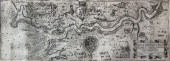
 15TH C BOOK SHEET (WOODBLOCK) -
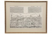
 Double Sheet Page from 'The Nuremberg Chronicle' full folio 1493 in Latin by Hartmann Schedel a world history this sheet depicting the town of Buda (CXXXIX) double glazed with mat in gold frame SS: 14 3/4'' x 21'' OS:
15TH C BOOK SHEET (WOODBLOCK) -
15TH C BOOK SHEET (WOODBLOCK) - Double Sheet Page from 'The Nuremberg Chronicle' full folio 1493 in Latin by Hartmann Schedel a world history this sheet depicting the town of Buda (CXXXIX) double glazed with mat in gold frame SS: 14 3/4'' x 21'' OS: -
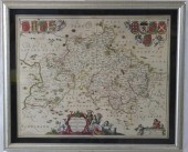
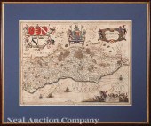
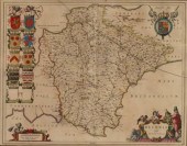
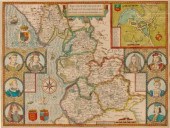
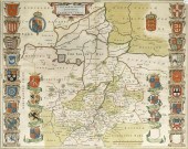
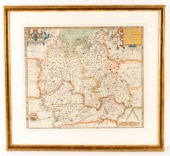 Christopher Saxton
 (1540-1610)/Oxfordshire, Berkshire and Buckinghamshire/coloured engraved map, 39.5cm x 46cm
Christopher Saxton
Christopher Saxton (1540-1610)/Oxfordshire, Berkshire and Buckinghamshire/coloured engraved map, 39.5cm x 46cm -
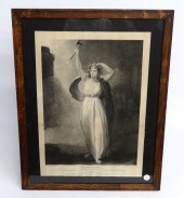 19th c. engraving ''Shakspeare''
 (engraved by George Romney/Francis Legat published in London). Sight 22 1/2'' x 16''.
19th c. engraving ''Shakspeare''
19th c. engraving ''Shakspeare'' (engraved by George Romney/Francis Legat published in London). Sight 22 1/2'' x 16''. -
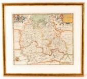 Christopher Saxton
 (1540-1610)/Oxfordshire, Berkshire and Buckinghamshire/colour print, 39.5cm x 46cm
Christopher Saxton
Christopher Saxton (1540-1610)/Oxfordshire, Berkshire and Buckinghamshire/colour print, 39.5cm x 46cm -
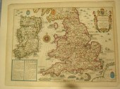 John Speed, 1627, The Invasions
 of England and Ireland With Al their Civill Wars Since the Conquest", a Historical map of England, Wales and Ireland "Are to be solde by Thomas Basset in Fleet Street and Richard Chiswell in Churchyard", image 15" x 20 1/2", text on both leaves verso, a highly decorative detailed map, superbly engraved by Cornelius Danckertsz, The map shows the various invasions and internal battles from the Norman invasion in 1066 to 1588. The land battles are marked by opposing phalanxes of troops, the invasion places from Sea by attacking fleets Estimate $800-1,200
John Speed, 1627, The Invasions
John Speed, 1627, The Invasions of England and Ireland With Al their Civill Wars Since the Conquest", a Historical map of England, Wales and Ireland "Are to be solde by Thomas Basset in Fleet Street and Richard Chiswell in Churchyard", image 15" x 20 1/2", text on both leaves verso, a highly decorative detailed map, superbly engraved by Cornelius Danckertsz, The map shows the various invasions and internal battles from the Norman invasion in 1066 to 1588. The land battles are marked by opposing phalanxes of troops, the invasion places from Sea by attacking fleets Estimate $800-1,200 -
 John Speed (1552-1629)/Britain as
 it was Devided in the Tyme of the Englishe Saxons especially during their Heptarchy/coloured engraved map/with text verso, 39cm x 51cm
John Speed (1552-1629)/Britain as
John Speed (1552-1629)/Britain as it was Devided in the Tyme of the Englishe Saxons especially during their Heptarchy/coloured engraved map/with text verso, 39cm x 51cm -
 17TH CENTURY COLORED MAP OF
 BUCKINGHAMSHIRE ANDBEDFORDSHIRE. ALLEGORICAL PEASANT SCENE AT THE BOTTOM. BY JOHN JOHNSON OF AMSTERDAM. GOOD ORIGINAL CONDITION WITH CREASE IN CENTER. MODERN SILVER LEAF FRAME AND MAT. SIGHT SIZE 16" X 19 3/4" , OVERALL 19 3/4" X 23 1/2" .
17TH CENTURY COLORED MAP OF
17TH CENTURY COLORED MAP OF BUCKINGHAMSHIRE ANDBEDFORDSHIRE. ALLEGORICAL PEASANT SCENE AT THE BOTTOM. BY JOHN JOHNSON OF AMSTERDAM. GOOD ORIGINAL CONDITION WITH CREASE IN CENTER. MODERN SILVER LEAF FRAME AND MAT. SIGHT SIZE 16" X 19 3/4" , OVERALL 19 3/4" X 23 1/2" . -
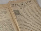 A number of historic
 proclamations and other documents of the years 1659 to 1715 including the taking and subsequent execution of Lord Monmouth after the rebellion of 1685 proclamations after the treaty of Breda 1667 details of the court which sentenced Charles I in 1648 and a later court sentencing after the Jacobite rebellion in 1715.
A number of historic
A number of historic proclamations and other documents of the years 1659 to 1715 including the taking and subsequent execution of Lord Monmouth after the rebellion of 1685 proclamations after the treaty of Breda 1667 details of the court which sentenced Charles I in 1648 and a later court sentencing after the Jacobite rebellion in 1715. -
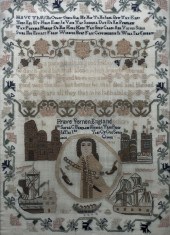 An early 19th century sampler
 worked in colours and depicting a portrait of Admiral Vernon victor of the Battle of Portobello together with depictions of ships castles and religious texts within a freely running border of flowers by Sarah C. Bingham Fright 1837 18ins x 13ins in rosewood frame and glazed and an early 19th century sampler with the Lords Prayer worked by Susanna Hookeys June 30th 1823 19ins x 16.75ins framed and glazed
An early 19th century sampler
An early 19th century sampler worked in colours and depicting a portrait of Admiral Vernon victor of the Battle of Portobello together with depictions of ships castles and religious texts within a freely running border of flowers by Sarah C. Bingham Fright 1837 18ins x 13ins in rosewood frame and glazed and an early 19th century sampler with the Lords Prayer worked by Susanna Hookeys June 30th 1823 19ins x 16.75ins framed and glazed -
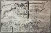 Matthaus Merian (1621-1687) -
 Engraving - ''Rivier Oder Gegent Von London'' - An unusual map of the River Thames illustrating the Dutch attack on the English Fleet anchored at Chatham in June 1667 8.75ins x 14ins thought to be published Frankfurt 1667 in Hogarth frame and glazed Provenance : O'Shea Gallery 89 Lower Sloane Street London SW1W 8DA. Purchased 24th June 1986
Matthaus Merian (1621-1687) -
Matthaus Merian (1621-1687) - Engraving - ''Rivier Oder Gegent Von London'' - An unusual map of the River Thames illustrating the Dutch attack on the English Fleet anchored at Chatham in June 1667 8.75ins x 14ins thought to be published Frankfurt 1667 in Hogarth frame and glazed Provenance : O'Shea Gallery 89 Lower Sloane Street London SW1W 8DA. Purchased 24th June 1986 -
 Jan Jansson (Dutch 1588-1664)
 "Somersettensis Comitatus Somerset Shire" and "Suthsexia vernacule Sussex" c. 1650 two hand-colored engraved copperplate maps from the Atlas Noveus with beautiful cartouches ships and compass roses sights 15 1/2 in. x 20 1/4 in. attractively matted and framed alike.
Jan Jansson (Dutch 1588-1664)
Jan Jansson (Dutch 1588-1664) "Somersettensis Comitatus Somerset Shire" and "Suthsexia vernacule Sussex" c. 1650 two hand-colored engraved copperplate maps from the Atlas Noveus with beautiful cartouches ships and compass roses sights 15 1/2 in. x 20 1/4 in. attractively matted and framed alike. -
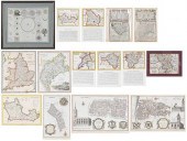 GROUP OF 14 MAPS OF GREAT
 BRITAIN, FRAMED CELESTIAL MAP...17th-19th century, engravings on laid or wove paper, all with hand colored highlights, comprising: John Speed, Darby Shire, London, circa 1630-1640, engraved by Peter Van Den Keere; John Owen & Emanuel Bowen, two maps from Britannia Depicta or Ogilby Improved , including A Map of Middlesex and Mona, Now Called Anglesey Island, circa 1720-1730; Benjamin Cole, three maps of wards of London including Walbrook Ward and Dowgate Ward , Queen Hith Ward and Vintry Ward , and Portsoken Ward , circa 1755; Archibald Fullarton & Co., Cumberland , Glasgow, circa 1840s; John Archer, Berkshire , circa 1840s, engraved for Dugdale's England & Wales Delineated ; five 19th century county maps, including Berkshire, Brecknockshire, Carnarvonshire, Radnorshire, and Merionethshire ; 19th century England and Wales map; all unframed, some matted, largest mat 14-3/4 x 20 in.; together with Homann Heirs, Schematismus Geographiae Mathematicae... , Nuremberg, 1753, sight 18 x 21-1/2 in.; carved, painted, and gilt wood frame, 25-1/8 x 28-1/4 in. Provenance: The Important Private Collection of a Rocky Mountain Couple Condition: toning and scattered light staining throughout, wear and small tears to edges, not examined under mats, some tape remnants; Mona with some tears along mat edges; Schematismus Geographiae Mathematicae... not examined out of frame, frame with light wear and abrasions
GROUP OF 14 MAPS OF GREAT
GROUP OF 14 MAPS OF GREAT BRITAIN, FRAMED CELESTIAL MAP...17th-19th century, engravings on laid or wove paper, all with hand colored highlights, comprising: John Speed, Darby Shire, London, circa 1630-1640, engraved by Peter Van Den Keere; John Owen & Emanuel Bowen, two maps from Britannia Depicta or Ogilby Improved , including A Map of Middlesex and Mona, Now Called Anglesey Island, circa 1720-1730; Benjamin Cole, three maps of wards of London including Walbrook Ward and Dowgate Ward , Queen Hith Ward and Vintry Ward , and Portsoken Ward , circa 1755; Archibald Fullarton & Co., Cumberland , Glasgow, circa 1840s; John Archer, Berkshire , circa 1840s, engraved for Dugdale's England & Wales Delineated ; five 19th century county maps, including Berkshire, Brecknockshire, Carnarvonshire, Radnorshire, and Merionethshire ; 19th century England and Wales map; all unframed, some matted, largest mat 14-3/4 x 20 in.; together with Homann Heirs, Schematismus Geographiae Mathematicae... , Nuremberg, 1753, sight 18 x 21-1/2 in.; carved, painted, and gilt wood frame, 25-1/8 x 28-1/4 in. Provenance: The Important Private Collection of a Rocky Mountain Couple Condition: toning and scattered light staining throughout, wear and small tears to edges, not examined under mats, some tape remnants; Mona with some tears along mat edges; Schematismus Geographiae Mathematicae... not examined out of frame, frame with light wear and abrasions -
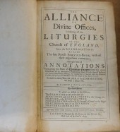 THE ALLIANCE OF DIVINE OFFICES,
 LONDON, 1699The Alliance of Divine Offices, London, 1699,
THE ALLIANCE OF DIVINE OFFICES,
THE ALLIANCE OF DIVINE OFFICES, LONDON, 1699The Alliance of Divine Offices, London, 1699, -
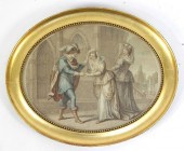
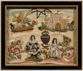 Fine 1671 betrothal needlework, man
 and woman in court attire separated by a shield and "1671", distant castle, birds and flowers in corners, partial sun at top, silk thread and purl with raised work, some painted details, on ivory satin ground, British, circa 1671, 8 x 9-3/4 in.; modern frame. Losses to silk thread, some areas unfinished, fading, shattering to silk ground, needle holes along edges, possibly formerly attached to a pillow. Edyth Medlin Antiques, Raleigh, North Carolina
Fine 1671 betrothal needlework, man
Fine 1671 betrothal needlework, man and woman in court attire separated by a shield and "1671", distant castle, birds and flowers in corners, partial sun at top, silk thread and purl with raised work, some painted details, on ivory satin ground, British, circa 1671, 8 x 9-3/4 in.; modern frame. Losses to silk thread, some areas unfinished, fading, shattering to silk ground, needle holes along edges, possibly formerly attached to a pillow. Edyth Medlin Antiques, Raleigh, North Carolina -
 Dated 1904
Dated 1904
Dated 1904 -
 JOHN NORDEN (1547-1625) AND JOHN
 SPEED (1552-1629), A MAP OF ESSEX coloured engraving, 39cm x 51cm, in later gilt frame and glazed
JOHN NORDEN (1547-1625) AND JOHN
JOHN NORDEN (1547-1625) AND JOHN SPEED (1552-1629), A MAP OF ESSEX coloured engraving, 39cm x 51cm, in later gilt frame and glazed -
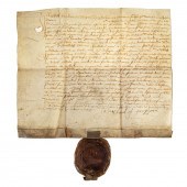 SCOTTISH RENAISSANCE DOCUMENT, 1572
 James Sandiland (c.1511-1579, sometime Grand Master of the Knights Hospitaller, 1st Lord Torphichen) original manuscript document in Latin and English, June 3, 1572, to John Browne, with a large seal affixed; faintly endorsed verso; 1 p., on vellum, 8 x 9 1/2 in.
SCOTTISH RENAISSANCE DOCUMENT, 1572
SCOTTISH RENAISSANCE DOCUMENT, 1572 James Sandiland (c.1511-1579, sometime Grand Master of the Knights Hospitaller, 1st Lord Torphichen) original manuscript document in Latin and English, June 3, 1572, to John Browne, with a large seal affixed; faintly endorsed verso; 1 p., on vellum, 8 x 9 1/2 in. -
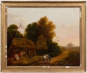 Painting, follower of Thomas
 Barker, travelers on path near a cottage, follower Thomas Barker of Bath, British, 1769-1847), oil on canvas, Christie's label verso, 25 x 30 in.; gilt wood and composition 18th century style frame. Original stretcher and tacking edge, crackle, cupping, retouch throughout affecting 40 percent of surface; frame with losses. Christie's U.K., December 19, 2006, lot 72.
Painting, follower of Thomas
Painting, follower of Thomas Barker, travelers on path near a cottage, follower Thomas Barker of Bath, British, 1769-1847), oil on canvas, Christie's label verso, 25 x 30 in.; gilt wood and composition 18th century style frame. Original stretcher and tacking edge, crackle, cupping, retouch throughout affecting 40 percent of surface; frame with losses. Christie's U.K., December 19, 2006, lot 72. -
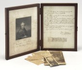 FRAMED A.L.S.: BISHOP JOHN
 CHEVERUSTo the lieutenant governor of Massachusetts. Pertains to appropriating a sum of money to support a teacher of Religion & Morality among the tribes of Penobscot of Passamaquoddy in 1798. Contained in a mahogany frame with a print of Cheverus on one side and the letter on the other. Together with a carte de viste of the bishop. Note: John Cheverus was the first Catholic bishop of Boston.
FRAMED A.L.S.: BISHOP JOHN
FRAMED A.L.S.: BISHOP JOHN CHEVERUSTo the lieutenant governor of Massachusetts. Pertains to appropriating a sum of money to support a teacher of Religion & Morality among the tribes of Penobscot of Passamaquoddy in 1798. Contained in a mahogany frame with a print of Cheverus on one side and the letter on the other. Together with a carte de viste of the bishop. Note: John Cheverus was the first Catholic bishop of Boston. -
 A late 16th/early 17th Century
 coloured engraving - ''Map of the Shyre of Kent divided into five lathes therof'' - Map of Kent showing London part of Surrey and Sussex 7.75ins x 14.25ins (Anonymous - thought to be the second state of the first separate printed map of Kent which was first published circa 1580. This example is probably issued circa 1625) in modern gilt moulded frame and glazed Provenance : O'Shea Gallery 89 Lower Sloane Street London SW1W 8DA
A late 16th/early 17th Century
A late 16th/early 17th Century coloured engraving - ''Map of the Shyre of Kent divided into five lathes therof'' - Map of Kent showing London part of Surrey and Sussex 7.75ins x 14.25ins (Anonymous - thought to be the second state of the first separate printed map of Kent which was first published circa 1580. This example is probably issued circa 1625) in modern gilt moulded frame and glazed Provenance : O'Shea Gallery 89 Lower Sloane Street London SW1W 8DA -
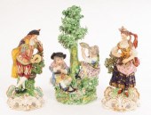 A Derby group of musicians, no.
 139, early 19th Century, 26cm high and a pair of musicians, no. 311
A Derby group of musicians, no.
A Derby group of musicians, no. 139, early 19th Century, 26cm high and a pair of musicians, no. 311 -
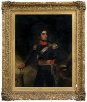 19th century English School
 portrait, gentleman in full uniform, standing with sword supporting proper right hand, inscription verso frame "2nd Marquis", unsigned, oil on canvas, late 18th/early 19th century, 56-1/8 x 44-1/4 in.; original monumental 19th century gilt wood and composition Louis XIV style frame with inward sloping cushion, acanthus on a crosshatched ground, corner shell and acanthus decoration. Lined, crackle, bitumen draw, abrasions bottom and upper right, two periods restoration 50 percent of surface retouched within draw crackle, large parts of uniform, background; frame with losses to composition. Estate of the late Judge John Emery Parks, Honolulu, Hawaii.
19th century English School
19th century English School portrait, gentleman in full uniform, standing with sword supporting proper right hand, inscription verso frame "2nd Marquis", unsigned, oil on canvas, late 18th/early 19th century, 56-1/8 x 44-1/4 in.; original monumental 19th century gilt wood and composition Louis XIV style frame with inward sloping cushion, acanthus on a crosshatched ground, corner shell and acanthus decoration. Lined, crackle, bitumen draw, abrasions bottom and upper right, two periods restoration 50 percent of surface retouched within draw crackle, large parts of uniform, background; frame with losses to composition. Estate of the late Judge John Emery Parks, Honolulu, Hawaii. -
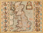
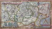
 MAP OF BRITANNIA, 1646, JAN JANSSON
 - HEPTARCHY,depicting the 7 kingdoms of Anglo Saxon England. Great colored engravings on borders showing the different kingdoms. Description on the back of a two-sided frame. Good condition, not laid down. Sight size 17 1/2" x 21 1/2", overall with frame 24 1/2" x 30".
MAP OF BRITANNIA, 1646, JAN JANSSON
MAP OF BRITANNIA, 1646, JAN JANSSON - HEPTARCHY,depicting the 7 kingdoms of Anglo Saxon England. Great colored engravings on borders showing the different kingdoms. Description on the back of a two-sided frame. Good condition, not laid down. Sight size 17 1/2" x 21 1/2", overall with frame 24 1/2" x 30". -
 Johannes Blaeu/Devonia vulgo
 Devon-Shire/Amsterdam, circa 1645/engraved map with contemporary hand colouring, decorative cartouche and mileage scale, slight spotting, 39.5cm x 50.5cm and /Cornubia sive Cornwallia/Amsterdam, circa 1650/engraved map with hand colouring, 39.5cm x 50.5cm (2)/Provenance: Sotheby's 7th April 1998, Lot 212 (part)
Johannes Blaeu/Devonia vulgo
Johannes Blaeu/Devonia vulgo Devon-Shire/Amsterdam, circa 1645/engraved map with contemporary hand colouring, decorative cartouche and mileage scale, slight spotting, 39.5cm x 50.5cm and /Cornubia sive Cornwallia/Amsterdam, circa 1650/engraved map with hand colouring, 39.5cm x 50.5cm (2)/Provenance: Sotheby's 7th April 1998, Lot 212 (part) -
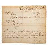 SAMUEL PEPYS, DS, 1668 Samuel Pepys
 (1633-1703, Secretary of the Admiralty, diarist) handwritten document, signed, dated February 20, 1668; 1 p., 8vo, 6 1/2 x 7 5/8 in.; an order for the "widow woodcock" of Chatham to repair various flags and ensigns, "being much ratteaten & torne," and that she be given clear instructions concerning thread and workmanship; signed by Pepys, l.r. and possibly endorsed in his hand; also signed by Col. Thomas Middleton, Surveyor of the Navy, and Tom Wilson, a secretary.
SAMUEL PEPYS, DS, 1668 Samuel Pepys
SAMUEL PEPYS, DS, 1668 Samuel Pepys (1633-1703, Secretary of the Admiralty, diarist) handwritten document, signed, dated February 20, 1668; 1 p., 8vo, 6 1/2 x 7 5/8 in.; an order for the "widow woodcock" of Chatham to repair various flags and ensigns, "being much ratteaten & torne," and that she be given clear instructions concerning thread and workmanship; signed by Pepys, l.r. and possibly endorsed in his hand; also signed by Col. Thomas Middleton, Surveyor of the Navy, and Tom Wilson, a secretary. -
 A Molteno Edward IV being
 introduced to Jane Shore stipple engraving
A Molteno Edward IV being
A Molteno Edward IV being introduced to Jane Shore stipple engraving -
 See lot 699
See lot 699
See lot 699 -
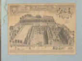 A 17 th century engraving of Sydney
 Sussex College by D. Loggan 46 x 35 cm together with two 19th century coloured prints of the same college by F. Mackenzie J. Le Keux.
A 17 th century engraving of Sydney
A 17 th century engraving of Sydney Sussex College by D. Loggan 46 x 35 cm together with two 19th century coloured prints of the same college by F. Mackenzie J. Le Keux. -
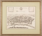
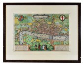 LODINUM FERACISSIMI ANGLIAE REGNI
 METROPOLIS MAPGeorge Braun and Franz Hogenberg, Published, Cologne, 1579, engraved by Hoefnagel, with four figures in foreground, a decorative cartouche, the arms of Queen Elizabeth displayed in the top left hand corner, with the arms of the City on the right, text in Latin on the reverse. Hand colored later, framed, mounted with conservation back for viewing. Site measurement 12.25 in by 18.5 in.
LODINUM FERACISSIMI ANGLIAE REGNI
LODINUM FERACISSIMI ANGLIAE REGNI METROPOLIS MAPGeorge Braun and Franz Hogenberg, Published, Cologne, 1579, engraved by Hoefnagel, with four figures in foreground, a decorative cartouche, the arms of Queen Elizabeth displayed in the top left hand corner, with the arms of the City on the right, text in Latin on the reverse. Hand colored later, framed, mounted with conservation back for viewing. Site measurement 12.25 in by 18.5 in. -
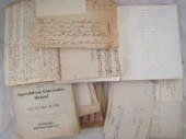 A quantity of historic documents
 and ephemera including a document dated 1480 documents of the 16th and 17th century several Acts of Parliament of William III George II etc. 17/18th loan and payment documents including dated 1691 for services in Ireland dated 1710 signed Walpole dated 1729 signed Marlborough and Godolphin books of verses etc.
A quantity of historic documents
A quantity of historic documents and ephemera including a document dated 1480 documents of the 16th and 17th century several Acts of Parliament of William III George II etc. 17/18th loan and payment documents including dated 1691 for services in Ireland dated 1710 signed Walpole dated 1729 signed Marlborough and Godolphin books of verses etc. -
 John Speed (1552-1629)/The
 Countie Pallatine of Lancaster/described and divided into hundreds, dated 1610/hand coloured engraved map, 39cm x 51.5cm
John Speed (1552-1629)/The
John Speed (1552-1629)/The Countie Pallatine of Lancaster/described and divided into hundreds, dated 1610/hand coloured engraved map, 39cm x 51.5cm -
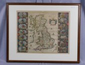
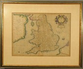 Early framed and matted
 hand-painted map of England. 14"x18.25"
Early framed and matted
Early framed and matted hand-painted map of England. 14"x18.25" -
 Lucas Janszoon Waghenaer
 (1534-1598) - Engraving - Rare early sea chart of the River Thames 7.5ins x 20.75ins titled in French and Dutch engraved by Benjamin Wright and published in Waghenaer's Thresoor Der Zeevaert 1601-1609 in moulded frame and glazed Provenance : Baynton-Williams Maltravers House 49 Maltravers Street Arundel West Sussex BN18 9BQ. Purchased 5th September 1984
Lucas Janszoon Waghenaer
Lucas Janszoon Waghenaer (1534-1598) - Engraving - Rare early sea chart of the River Thames 7.5ins x 20.75ins titled in French and Dutch engraved by Benjamin Wright and published in Waghenaer's Thresoor Der Zeevaert 1601-1609 in moulded frame and glazed Provenance : Baynton-Williams Maltravers House 49 Maltravers Street Arundel West Sussex BN18 9BQ. Purchased 5th September 1984 -
 JOANNES JANSSONIUS (1588-1664)
 MAPJoannes Janssonius (1588-1664), "Vienna Austriae/Wien in Oostenreyk", Amsterdam, 1682, engraved bird's-eye view of Vienna; with a key, in Latin, of notable landmarks, 15 1/2 in. x 20 in., matted and framed Provenance: Collection of Brooke and Maria Fox, Metairie, LA
JOANNES JANSSONIUS (1588-1664)
JOANNES JANSSONIUS (1588-1664) MAPJoannes Janssonius (1588-1664), "Vienna Austriae/Wien in Oostenreyk", Amsterdam, 1682, engraved bird's-eye view of Vienna; with a key, in Latin, of notable landmarks, 15 1/2 in. x 20 in., matted and framed Provenance: Collection of Brooke and Maria Fox, Metairie, LA -
 JOAN BLAEU CAMBRIDGE SHIRE
 double page engraved map from volume IV of the Atlas Novus, Latin text verso, 1645, coloured and enriched in gilt, with wide margins, closer at the top, 47.5 x 59cm
JOAN BLAEU CAMBRIDGE SHIRE
JOAN BLAEU CAMBRIDGE SHIRE double page engraved map from volume IV of the Atlas Novus, Latin text verso, 1645, coloured and enriched in gilt, with wide margins, closer at the top, 47.5 x 59cm -
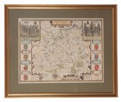 JOHN SPEED (1552-1629), A MAP OF
 SURREY coloured engraving, 39cm x 51cm, published by Jodocus Hondius, 1610, in later gilt frame and glazed
JOHN SPEED (1552-1629), A MAP OF
JOHN SPEED (1552-1629), A MAP OF SURREY coloured engraving, 39cm x 51cm, published by Jodocus Hondius, 1610, in later gilt frame and glazed
...many more examples with full details are available to our members - Learn more
Easy & Visual methods to Identify & Appraise Antiques & Collectibles
EASY. FAST. ACCURATE.
Research at its best
We are here to help!
Our research tools include:

Thousands of makers marks for PORCELAIN, POTTERY CHINAWARE, FIGURINES, VASES
see details...

Thousands of marks & hallmarks for SILVER & JEWELRY, PEWTER, PRECIOUS METALS, SILVERPLATE
see details...
