Pricing Guides & Dictionary of Makers Marks for Antiques & Collectibles
A few examples of appraisal values for
ANTIETAM
Search our price guide for your own treasures
-
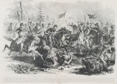
 19TH C. BATTLE OF ANTIETAM,
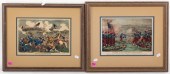
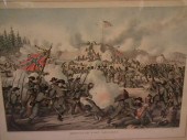
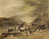
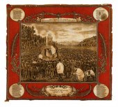
 LITHOGRAPH/ENGRAVING 1) E.R. & E.C. Kellogg. "Battle of Antietam, Sept. 17, 1862," color lithograph, sight size: 9 1/4 x 12 3/4 in., framed 2) H.H.Lloyd."Battle of Antietam," wood engraving, sight size: 9 x 13 in., framed.
19TH C. BATTLE OF ANTIETAM,
19TH C. BATTLE OF ANTIETAM, LITHOGRAPH/ENGRAVING 1) E.R. & E.C. Kellogg. "Battle of Antietam, Sept. 17, 1862," color lithograph, sight size: 9 1/4 x 12 3/4 in., framed 2) H.H.Lloyd."Battle of Antietam," wood engraving, sight size: 9 x 13 in., framed. -
 [Historic Newspaper: Battle of
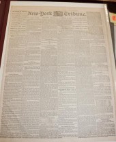
 Antietam Emancipation] New-York Tribune September 24 1862 containing extensive reporting of the fighting in Maryland and on other fronts together with news of the preliminary Emancipation Proclamation and editorials on its impact; 8pp. double folio intersecting folds some scattered light staining Estimate $ 300-500 Removed from a bound volume.
[Historic Newspaper: Battle of
[Historic Newspaper: Battle of Antietam Emancipation] New-York Tribune September 24 1862 containing extensive reporting of the fighting in Maryland and on other fronts together with news of the preliminary Emancipation Proclamation and editorials on its impact; 8pp. double folio intersecting folds some scattered light staining Estimate $ 300-500 Removed from a bound volume. -
 Gibson & Co. The Battle of Antietam
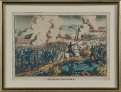
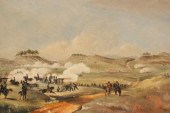
 MD Gibson & Co. The Battle of Antietam MD hand-colored lithograph with publisher mark l.l.; 7.5 x 11.25 in. Condition: Toning with a few waterstains in u.l.
Gibson & Co. The Battle of Antietam
Gibson & Co. The Battle of Antietam MD Gibson & Co. The Battle of Antietam MD hand-colored lithograph with publisher mark l.l.; 7.5 x 11.25 in. Condition: Toning with a few waterstains in u.l. -
 RARE POSTWAR ANTIETAM NATIONAL
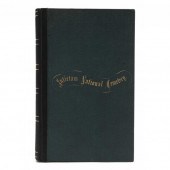
 CEMETERY DEDICATION BOOK History of Antietam National Cemetery, Including a Descriptive List of the Loyal Soldiers Buried Therein; Together with the Ceremonies and Address on the Occasion of the Dedication of the Grounds, September, 17th, 1867 (Baltimore: John W. Woods, Steam Printer, 1869), inscribed "No 29" on title page, the frontispiece consists of an albumen photograph with imprint credit of Hagerstown, Maryland photographer B.W.T. Phreaner and title, "View of Lodge-House From North-Eastern Position," a second image naming Phreaner, "View of Sharpsburg From Cemetery Hill, is placed before the "Descriptive List" of soldiers interred in the cemetery, 201 pages, octavo (9 in), green cloth with "Antietam National Cemetery" in gilt on top board.
RARE POSTWAR ANTIETAM NATIONAL
RARE POSTWAR ANTIETAM NATIONAL CEMETERY DEDICATION BOOK History of Antietam National Cemetery, Including a Descriptive List of the Loyal Soldiers Buried Therein; Together with the Ceremonies and Address on the Occasion of the Dedication of the Grounds, September, 17th, 1867 (Baltimore: John W. Woods, Steam Printer, 1869), inscribed "No 29" on title page, the frontispiece consists of an albumen photograph with imprint credit of Hagerstown, Maryland photographer B.W.T. Phreaner and title, "View of Lodge-House From North-Eastern Position," a second image naming Phreaner, "View of Sharpsburg From Cemetery Hill, is placed before the "Descriptive List" of soldiers interred in the cemetery, 201 pages, octavo (9 in), green cloth with "Antietam National Cemetery" in gilt on top board. -
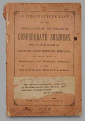 Rare Civil War Record of
 Confederate Burials A Descriptive List of the Burial Places of the Remains of Confederate Soldiers, Who Fell in the Battles of Antietam, South Mountain, Monocacy, and Other Points in Washington and Frederick Counties, in the State of Maryland, by the Maryland Board of Trustees of the Antietam National Cemetery under the direction of Governor Oden Bowie, published by "Free Press", Hagerstown, Maryland, 1869, soft cover, 84 pp., 8-5/8 x 5-5/8 in.,
Rare Civil War Record of
Rare Civil War Record of Confederate Burials A Descriptive List of the Burial Places of the Remains of Confederate Soldiers, Who Fell in the Battles of Antietam, South Mountain, Monocacy, and Other Points in Washington and Frederick Counties, in the State of Maryland, by the Maryland Board of Trustees of the Antietam National Cemetery under the direction of Governor Oden Bowie, published by "Free Press", Hagerstown, Maryland, 1869, soft cover, 84 pp., 8-5/8 x 5-5/8 in., -
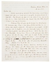 (CIVIL WAR) BRAGG EDWARD S. attrib.
 A group of two autographed letters to his wife. In the letters Bragg discusses his military activities and refers to Gen. McClellan Antietam and ''Old Abe.'' Signed ''E'' dated November 30 1852 (sc. 1862) and Sunday April 6 1863 4pp. each. Folded in thirds; five line horizontal strip cut from letter dated ''1852.'' Edward Stuyvesant Bragg (1827-1912) of Fond du Lac Wisconsin advanced in rank from captain of the 6th Wisconsin Volunteer Infantry in 1861 to Brigadier General in 1864 and was engaged in the battles of Gainesville South Mountain Antietam (where he was severely wounded) Fredericksburg Chancellorsville the Wilderness Spotsylvania Laurel Hill North Anna and Cold Harbor as well as commanding the Iron Brigade in their assault on Petersburg. In addition to his field work he was involved in politics and a delegate to the Charleston Democratic Convention of 1860 was elected as state senator in 1867 and served four terms in Congress (1877-83 and 1885-1887). (Dictionary of American Biography vol. 2 pp. 587-588)
(CIVIL WAR) BRAGG EDWARD S. attrib.
(CIVIL WAR) BRAGG EDWARD S. attrib. A group of two autographed letters to his wife. In the letters Bragg discusses his military activities and refers to Gen. McClellan Antietam and ''Old Abe.'' Signed ''E'' dated November 30 1852 (sc. 1862) and Sunday April 6 1863 4pp. each. Folded in thirds; five line horizontal strip cut from letter dated ''1852.'' Edward Stuyvesant Bragg (1827-1912) of Fond du Lac Wisconsin advanced in rank from captain of the 6th Wisconsin Volunteer Infantry in 1861 to Brigadier General in 1864 and was engaged in the battles of Gainesville South Mountain Antietam (where he was severely wounded) Fredericksburg Chancellorsville the Wilderness Spotsylvania Laurel Hill North Anna and Cold Harbor as well as commanding the Iron Brigade in their assault on Petersburg. In addition to his field work he was involved in politics and a delegate to the Charleston Democratic Convention of 1860 was elected as state senator in 1867 and served four terms in Congress (1877-83 and 1885-1887). (Dictionary of American Biography vol. 2 pp. 587-588) -
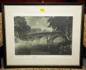 FRAMED A.A. BODINE PHOTO OF
 BURNSIDE BRIDGE The focal point of the Antietam battlefield, signed and titled in the lower margin.
FRAMED A.A. BODINE PHOTO OF
FRAMED A.A. BODINE PHOTO OF BURNSIDE BRIDGE The focal point of the Antietam battlefield, signed and titled in the lower margin. -
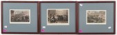 3 FRAMED 19TH C. MARYLAND
 CONFLICT THEMED PRINTS 1) "Massachusetts Militia Passing Through Baltimore," color engraving, sight size: 6 x 8 in. 2) "Attack of the Massachusetts 6th at Baltimore," color engraving, sight size: 5 1/4 x 7 1/2 in. 3) "Battle of Antietam-Taking of the Bridge on Antietam Creek," color engraving, sight size: 5 1/2 x 7 in.
3 FRAMED 19TH C. MARYLAND
3 FRAMED 19TH C. MARYLAND CONFLICT THEMED PRINTS 1) "Massachusetts Militia Passing Through Baltimore," color engraving, sight size: 6 x 8 in. 2) "Attack of the Massachusetts 6th at Baltimore," color engraving, sight size: 5 1/4 x 7 1/2 in. 3) "Battle of Antietam-Taking of the Bridge on Antietam Creek," color engraving, sight size: 5 1/2 x 7 in. -
 [Civil War - Manuscripts] Gathering
 of Civil War and Other Ephemera Lot of 50+ items many related to the Civil War. Items include: a 1906 booklet The Battlefield of Antietam with 32pp of text photographs and maps compiled by official tour guide Oliver T. Reilly; an 1858 Illinois River Railroad Co. indenture; discharge papers of Private David McClain Co. G 130th Illinois Infantry; discharge papers of Milton J. Ryason Co. F 16th Illinois Infantry; a goodwill bond from the Piedmont Sanatorium of Burkeville Virginia for cooperation with the Negro Organization Society; a 6.5'' x 8.5'' albumen photograph of a young soldier; an 1860 copy of the Chening Express of Savannah Georgia; program from the 31st Reunion and Banquet of the Society of the Army of the Tennessee at Chicago 1891 1910s discharge and related papers of Sgt. John Lorkoski U.S. Army Quartermaster Corp; 10'' x 12'' mounted photograph of man wearing a Co. M 2nd Artillery kepi seated outside with his family; sheet music for the ''Battle of Gettysburg Descriptive March '' by E.T. Paul with nice chromolithographed cover; a 1928 booklet Life of U.S. Grant / Description of the Tomb; The Soldier's Pocket Book for the year of 1862 published by the Presbyterian Board of Publication; a CDV of an unidentified officer; two $20 CSA notes; $1000 CSA bond; $7000 CSA bond; and several more discharges pay receipts and related papers of Civil War soldiers.
[Civil War - Manuscripts] Gathering
[Civil War - Manuscripts] Gathering of Civil War and Other Ephemera Lot of 50+ items many related to the Civil War. Items include: a 1906 booklet The Battlefield of Antietam with 32pp of text photographs and maps compiled by official tour guide Oliver T. Reilly; an 1858 Illinois River Railroad Co. indenture; discharge papers of Private David McClain Co. G 130th Illinois Infantry; discharge papers of Milton J. Ryason Co. F 16th Illinois Infantry; a goodwill bond from the Piedmont Sanatorium of Burkeville Virginia for cooperation with the Negro Organization Society; a 6.5'' x 8.5'' albumen photograph of a young soldier; an 1860 copy of the Chening Express of Savannah Georgia; program from the 31st Reunion and Banquet of the Society of the Army of the Tennessee at Chicago 1891 1910s discharge and related papers of Sgt. John Lorkoski U.S. Army Quartermaster Corp; 10'' x 12'' mounted photograph of man wearing a Co. M 2nd Artillery kepi seated outside with his family; sheet music for the ''Battle of Gettysburg Descriptive March '' by E.T. Paul with nice chromolithographed cover; a 1928 booklet Life of U.S. Grant / Description of the Tomb; The Soldier's Pocket Book for the year of 1862 published by the Presbyterian Board of Publication; a CDV of an unidentified officer; two $20 CSA notes; $1000 CSA bond; $7000 CSA bond; and several more discharges pay receipts and related papers of Civil War soldiers. -
 American school 19th century
 "general meade's headquarters gettysburg battlefield" A collage, unsigned, titled in ink, watercolor, ink and cut paper on paper mounted on panel, with wooded case. H: 13 in. W: 20 1/4 in. PROVENANCE: Ex. collection of Andrew and Betsy Wyeth
American school 19th century
American school 19th century "general meade's headquarters gettysburg battlefield" A collage, unsigned, titled in ink, watercolor, ink and cut paper on paper mounted on panel, with wooded case. H: 13 in. W: 20 1/4 in. PROVENANCE: Ex. collection of Andrew and Betsy Wyeth -
 ANTIQUE CIVIL WAR BATTLE
 PRINTAntique colored lithograph Assault on Fort Sanders, Nov. 29, 1863 by Kurz and Allen of Chicago 1891. Heavy Confederate losses in this battle. 20 x 27 inches view size, framed 29 x 36 inches. VG condition.
ANTIQUE CIVIL WAR BATTLE
ANTIQUE CIVIL WAR BATTLE PRINTAntique colored lithograph Assault on Fort Sanders, Nov. 29, 1863 by Kurz and Allen of Chicago 1891. Heavy Confederate losses in this battle. 20 x 27 inches view size, framed 29 x 36 inches. VG condition. -
 [War of 1812] Two titles concerning
 the Battle for Baltimore (September 1814) 1) ''The Citizens Soldiers at Northpoint and Fort McHenry September 12 and 13 1814'' (Baltimore Freeman & Goodsmith circa 1840) octavo wraps with printed paper label; 2) ''The Citizens Soldiers at Northpoint and Fort McHenry September 12 and 13 1814'' (Baltimore C. S. Saffell 1889) octavo pictorial cloth Estimate $ 60-90
[War of 1812] Two titles concerning
[War of 1812] Two titles concerning the Battle for Baltimore (September 1814) 1) ''The Citizens Soldiers at Northpoint and Fort McHenry September 12 and 13 1814'' (Baltimore Freeman & Goodsmith circa 1840) octavo wraps with printed paper label; 2) ''The Citizens Soldiers at Northpoint and Fort McHenry September 12 and 13 1814'' (Baltimore C. S. Saffell 1889) octavo pictorial cloth Estimate $ 60-90 -
 ANTIQUE "L.W. MINNIGH, THE
 BATTLEFIELD OF GETTYSBURG 18...Antique "L.W. Minnigh, The Battlefield of Gettysburg 1863" Map , circa 1905, painted by Gatchel & Manning Philadelphia 15.5in x 11.5 in. framed 17.5 in. x 13.5 in. Condition: Items may have wear and tear, imperfections or the effects of aging. Please contact the gallery for further details prior to bidding. Any condition statement given as a courtesy should not be treated as fact.
ANTIQUE "L.W. MINNIGH, THE
ANTIQUE "L.W. MINNIGH, THE BATTLEFIELD OF GETTYSBURG 18...Antique "L.W. Minnigh, The Battlefield of Gettysburg 1863" Map , circa 1905, painted by Gatchel & Manning Philadelphia 15.5in x 11.5 in. framed 17.5 in. x 13.5 in. Condition: Items may have wear and tear, imperfections or the effects of aging. Please contact the gallery for further details prior to bidding. Any condition statement given as a courtesy should not be treated as fact. -
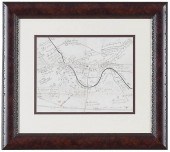
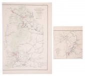 (2) 19th Century Civil War
 battlefield maps, with certificates of authenticity guaranteed to be original plates from the Atlas to Accompany the Official Records of the Union and Confederate Armies, c/o Map of the Battlefield about Frederick City and the Monocacy River MD July 9 1864, Battlefields of South Mountain showing the positions of the Forces of the United States and of the Enemy during the Battle fought by the Army of the Potomac under the Command of Maj Gen George B McClellan Sept 14 1862
(2) 19th Century Civil War
(2) 19th Century Civil War battlefield maps, with certificates of authenticity guaranteed to be original plates from the Atlas to Accompany the Official Records of the Union and Confederate Armies, c/o Map of the Battlefield about Frederick City and the Monocacy River MD July 9 1864, Battlefields of South Mountain showing the positions of the Forces of the United States and of the Enemy during the Battle fought by the Army of the Potomac under the Command of Maj Gen George B McClellan Sept 14 1862 -
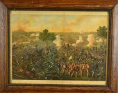 BATTLE OF GETTYSBURG 1884
 LITHOGRAPH IN COLORImpressive color lithograph of the Battle of Gettysburg Kurz and Allison 1884 two vertical discolorations near the left border another right of center H 19.5'' x W 25.5'' Private collection Madison Heights Mi.
BATTLE OF GETTYSBURG 1884
BATTLE OF GETTYSBURG 1884 LITHOGRAPH IN COLORImpressive color lithograph of the Battle of Gettysburg Kurz and Allison 1884 two vertical discolorations near the left border another right of center H 19.5'' x W 25.5'' Private collection Madison Heights Mi. -
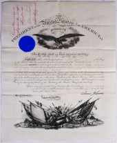 ANDREW JOHNSON PROMOTIONS OF
 UNION WAR HEROFour documents from the office of the president, including three Brevet promotions, recognizing John Egan, of the 1st US Artillery, for gallantry and merit in the battles of Antietam, Gettysburg and Cold Harbor. (Read more about the West Point graduate here: http://antietam.aotw.org/officers.php?officer_id=13642) Documents measure about 19-1/2" x 15-1/2".
ANDREW JOHNSON PROMOTIONS OF
ANDREW JOHNSON PROMOTIONS OF UNION WAR HEROFour documents from the office of the president, including three Brevet promotions, recognizing John Egan, of the 1st US Artillery, for gallantry and merit in the battles of Antietam, Gettysburg and Cold Harbor. (Read more about the West Point graduate here: http://antietam.aotw.org/officers.php?officer_id=13642) Documents measure about 19-1/2" x 15-1/2". -
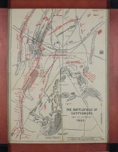
 MAP: "GETTYSBURG BATTLE-FIELD",
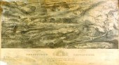
 BY JOHN B. BACHELDER, 1863, BIRDSEYE VIEW LITHOGRAPH, PUBLISHED BY ENDICOTT & CO., NEW YORK, TEARS A...MAP: "Gettysburg Battle-Field", by John B. Bachelder, 1863, birdseye view lithograph, published by Endicott & Co., New York, tears and repairs, including loss UL and LL, framed behind glass, sold as found, ss: 20" h. x 35 1/2" w. [NOTE: A large scale and very detailed plan of the Gettysburg battlefield published immediately after the momentous campaign. John Bachelder (1825-1894) was a highly esteemed artist of the period, who arrived at Gettysburg within days of the battle. He did considerable research and drawings on the spot, which resulted in this famous isometric drawing of the Gettysburg battlefield published in the fall of 1863. Bachelder went on to become one of the foremost scholars of the battle of Gettysburg and served as a director of the Gettysburg Battlefield Memorial Association. He was scheduled to serve on the commission that established Gettysburg as a National Military Park, but died in 1894 before the work began. This skillfully drawn and very informative birdseye view proudly sports an endorsement by Major General George Meade below. The plan is further endorsed by six other generals, along with five dignitaries of the town. The twenty-five square mile plan uses perspective, shading and coloring to describe the topography of the battlefield. Drainage, vegetation, roads and streets, railroads, bridges, houses and names of residents, along with notations of where officers were killed or wounded, are all indicated. The locations of the corps, divisions, brigades, of both armies, with the names of commanding officers, are given in detail. Badge symbols are used to identify the Federal Corps. This ambitious plan is distinctive for several reasons. Firstly, it represents one of the most accurate, thorough and immediate pieces of visual reporting that came out during the war, and as a result was a great commercial success. Further, as a handsomely drawn birdseye view, it fits into that important tradition of 19th-century city views that is such an enduring part of early American lithography. Ref.: Richard W. Stephenson. Civil War Maps. An Annotated List of Maps and Atlases in Map Collections of the Library of Congress. Washington, 1961, #321.]
MAP: "GETTYSBURG BATTLE-FIELD",
MAP: "GETTYSBURG BATTLE-FIELD", BY JOHN B. BACHELDER, 1863, BIRDSEYE VIEW LITHOGRAPH, PUBLISHED BY ENDICOTT & CO., NEW YORK, TEARS A...MAP: "Gettysburg Battle-Field", by John B. Bachelder, 1863, birdseye view lithograph, published by Endicott & Co., New York, tears and repairs, including loss UL and LL, framed behind glass, sold as found, ss: 20" h. x 35 1/2" w. [NOTE: A large scale and very detailed plan of the Gettysburg battlefield published immediately after the momentous campaign. John Bachelder (1825-1894) was a highly esteemed artist of the period, who arrived at Gettysburg within days of the battle. He did considerable research and drawings on the spot, which resulted in this famous isometric drawing of the Gettysburg battlefield published in the fall of 1863. Bachelder went on to become one of the foremost scholars of the battle of Gettysburg and served as a director of the Gettysburg Battlefield Memorial Association. He was scheduled to serve on the commission that established Gettysburg as a National Military Park, but died in 1894 before the work began. This skillfully drawn and very informative birdseye view proudly sports an endorsement by Major General George Meade below. The plan is further endorsed by six other generals, along with five dignitaries of the town. The twenty-five square mile plan uses perspective, shading and coloring to describe the topography of the battlefield. Drainage, vegetation, roads and streets, railroads, bridges, houses and names of residents, along with notations of where officers were killed or wounded, are all indicated. The locations of the corps, divisions, brigades, of both armies, with the names of commanding officers, are given in detail. Badge symbols are used to identify the Federal Corps. This ambitious plan is distinctive for several reasons. Firstly, it represents one of the most accurate, thorough and immediate pieces of visual reporting that came out during the war, and as a result was a great commercial success. Further, as a handsomely drawn birdseye view, it fits into that important tradition of 19th-century city views that is such an enduring part of early American lithography. Ref.: Richard W. Stephenson. Civil War Maps. An Annotated List of Maps and Atlases in Map Collections of the Library of Congress. Washington, 1961, #321.] -
 PASTEL/CHARCOAL BATTLE OF
 CUMBERLAND GAP, UNION EVACUAT...19th century pastel/charcoal depicting the September 17th, 1863 evacuation of Union Brigadier General George Washington Morgan, Commander of the 7th Division of the Army of the Ohio, from Cumberland Gap, near the junction of Kentucky, Virginia, and Tennessee. During the Civil War, Cumberland Gap was held alternately by Union and Confederate armies. Union forces under Gen. George W. Morgan occupied it June 18 to Sept. 17, 1862. Cut off from supplies and surrounded, General George Morgan with 9,000 men retreated successfully to Greenup, KY on Ohio River, 200 miles in 16 days over mountain roads, and despite the harassment of CSA Colonel John H. Morgan's Raiders. (Information courtesy of the Kentucky Historical Society). Note: this work is very similar to another 19th century Cumberland Gap evacuation drawing on file with the Library of Congress. Sight: 21 1/2" H x 26 3/4" W. Framed: 32 5/8" H x 37 3/4" W. 3rd quarter of 19th century, East Tennessee. (Higher-resolution photos are available at www.caseantiques.com) Condition: Work laid down on old cardstock. Margins under matte with foxing and toning.
PASTEL/CHARCOAL BATTLE OF
PASTEL/CHARCOAL BATTLE OF CUMBERLAND GAP, UNION EVACUAT...19th century pastel/charcoal depicting the September 17th, 1863 evacuation of Union Brigadier General George Washington Morgan, Commander of the 7th Division of the Army of the Ohio, from Cumberland Gap, near the junction of Kentucky, Virginia, and Tennessee. During the Civil War, Cumberland Gap was held alternately by Union and Confederate armies. Union forces under Gen. George W. Morgan occupied it June 18 to Sept. 17, 1862. Cut off from supplies and surrounded, General George Morgan with 9,000 men retreated successfully to Greenup, KY on Ohio River, 200 miles in 16 days over mountain roads, and despite the harassment of CSA Colonel John H. Morgan's Raiders. (Information courtesy of the Kentucky Historical Society). Note: this work is very similar to another 19th century Cumberland Gap evacuation drawing on file with the Library of Congress. Sight: 21 1/2" H x 26 3/4" W. Framed: 32 5/8" H x 37 3/4" W. 3rd quarter of 19th century, East Tennessee. (Higher-resolution photos are available at www.caseantiques.com) Condition: Work laid down on old cardstock. Margins under matte with foxing and toning. -
 William M. Apple Civil War
 historical memorabilia including two tintypes, family letters from Fort McHenry, Cedar Creek, Camp Russell, etc., a scent bottle with eagle clasp, and two books: "Views of Gettysburg Battlefield" and "Battles of the War for the Union". Tintype: 3 1/4" x 2 1/2".
William M. Apple Civil War
William M. Apple Civil War historical memorabilia including two tintypes, family letters from Fort McHenry, Cedar Creek, Camp Russell, etc., a scent bottle with eagle clasp, and two books: "Views of Gettysburg Battlefield" and "Battles of the War for the Union". Tintype: 3 1/4" x 2 1/2". -
 English School, 19th Century/A
 Battle Scene/possibly the Crimean War, depicting soldiers, artillery and cavalry with encampment upon the hills/oil on paper, 31cm x 46.5cm
English School, 19th Century/A
English School, 19th Century/A Battle Scene/possibly the Crimean War, depicting soldiers, artillery and cavalry with encampment upon the hills/oil on paper, 31cm x 46.5cm -
 Confederate General George
 Pickett CDV by Brady An E. & H.T. Anthony backmarked CDV featuring a vignette portrait from a Brady negative. George Pickett (1825-1875) was a Confederate major general primarily remembered for leading ''Picket's Charge'' on the final day of the of Gettysburg an unsuccessful assault the marked the ''High Water Mark of the Confederacy.'' Condition: Very good condition.
Confederate General George
Confederate General George Pickett CDV by Brady An E. & H.T. Anthony backmarked CDV featuring a vignette portrait from a Brady negative. George Pickett (1825-1875) was a Confederate major general primarily remembered for leading ''Picket's Charge'' on the final day of the of Gettysburg an unsuccessful assault the marked the ''High Water Mark of the Confederacy.'' Condition: Very good condition. -
 CIVIL WAR ILLUSTRATION, BATTLE OF
 YELLOW TAVERNAntique Civil War illustration of the War in Virginia, depicting the Battle of Yellow Tavern, May 11th, 1864. Overall framed size is 27" x 22". Excellent condition with hand coloring. shipping info This item will need to be shipped by a packing company of your choice. We maintain a list of reliable shippers, or you may choose your own.
CIVIL WAR ILLUSTRATION, BATTLE OF
CIVIL WAR ILLUSTRATION, BATTLE OF YELLOW TAVERNAntique Civil War illustration of the War in Virginia, depicting the Battle of Yellow Tavern, May 11th, 1864. Overall framed size is 27" x 22". Excellent condition with hand coloring. shipping info This item will need to be shipped by a packing company of your choice. We maintain a list of reliable shippers, or you may choose your own. -
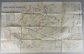
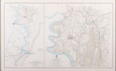 CIVIL WAR MAP 1892, HARPER'S FERRY,
 W. VA.; ANTIETAM MD.; SHARPSBURG MD.; -ATLAS OF THE WAR OF THE REBELLION .... PLATE XXIX, ENGRAVING: 18 X 29 1/8 IN.; 21 1/4 X 32 IN. (FRAMED)CIVIL WAR MAP 1892, HARPER'S FERRY, W. VA.; ANTIETAM MD.; SHARPSBURG MD.; -ATLAS OF THE WAR OF THE REBELLION .... PLATE XXIX, Engraving: 18 x 29 1/8 in.; 21 1/4 x 32 in. (framed) Framed; Atlas of the war of the Rebellion giving Union and Confederate armies by actual surveys by the Union and Confederate engineers, and approved by the officers in command, of all the maps herein published; 1892 Engraving: 18 x 29 1/8 in.; 21 1/4 x 32 in. (framed)
CIVIL WAR MAP 1892, HARPER'S FERRY,
CIVIL WAR MAP 1892, HARPER'S FERRY, W. VA.; ANTIETAM MD.; SHARPSBURG MD.; -ATLAS OF THE WAR OF THE REBELLION .... PLATE XXIX, ENGRAVING: 18 X 29 1/8 IN.; 21 1/4 X 32 IN. (FRAMED)CIVIL WAR MAP 1892, HARPER'S FERRY, W. VA.; ANTIETAM MD.; SHARPSBURG MD.; -ATLAS OF THE WAR OF THE REBELLION .... PLATE XXIX, Engraving: 18 x 29 1/8 in.; 21 1/4 x 32 in. (framed) Framed; Atlas of the war of the Rebellion giving Union and Confederate armies by actual surveys by the Union and Confederate engineers, and approved by the officers in command, of all the maps herein published; 1892 Engraving: 18 x 29 1/8 in.; 21 1/4 x 32 in. (framed) -
 A mixed lot. An antique view of the
 siege and battle of Tergovist seen from Siebenburg 26 x 16cm a pencil sketch of three gentlemen 20 x 15cm and a metallic thread tapestry of a dragon 10 x 10cm.
A mixed lot. An antique view of the
A mixed lot. An antique view of the siege and battle of Tergovist seen from Siebenburg 26 x 16cm a pencil sketch of three gentlemen 20 x 15cm and a metallic thread tapestry of a dragon 10 x 10cm. -
 MILITARIA, BATTLE OF AMIENS MAP,
 DATED 1918Military map, The Battle of Amiens, a rare World War I battle map titled “Harbonnières” (Northern France). Dated 2nd August 1918. Map shows the British front line, along with troop placements, artillery positions, headquarters, etc. Amiens was the beginning of the end of the 1st World War of which Canada played a decisive role. Condition: Folds, tears at crease, stains. Dimensions, 34.5" x 22.25".
MILITARIA, BATTLE OF AMIENS MAP,
MILITARIA, BATTLE OF AMIENS MAP, DATED 1918Military map, The Battle of Amiens, a rare World War I battle map titled “Harbonnières” (Northern France). Dated 2nd August 1918. Map shows the British front line, along with troop placements, artillery positions, headquarters, etc. Amiens was the beginning of the end of the 1st World War of which Canada played a decisive role. Condition: Folds, tears at crease, stains. Dimensions, 34.5" x 22.25". -
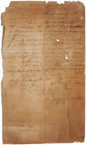 War of 1812 Soldier's Letter
 dated December 21, 1814, from Micajah C. Rogers to an unknown officer, in the "Vicinity of Fort Montgomery" (probably Fort Montgomery in Mississippi Territory), written in the weeks between the Battles of Pensacola and New Orleans and only days before the signing of the Treaty of Ghent ended the war, describing reconnaissance along the Escambia River, Major Blue's troop movements, and the capture and killing of Indians in Pensacola, 17 lines on one page, handwritten in brown ink on laid paper, 12 x 7-1/8 in.,
War of 1812 Soldier's Letter
War of 1812 Soldier's Letter dated December 21, 1814, from Micajah C. Rogers to an unknown officer, in the "Vicinity of Fort Montgomery" (probably Fort Montgomery in Mississippi Territory), written in the weeks between the Battles of Pensacola and New Orleans and only days before the signing of the Treaty of Ghent ended the war, describing reconnaissance along the Escambia River, Major Blue's troop movements, and the capture and killing of Indians in Pensacola, 17 lines on one page, handwritten in brown ink on laid paper, 12 x 7-1/8 in., -
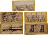
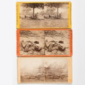 Alexander Gardner Stereoview of
 Dead at Gettysburg Plus Lot of 3 including an Alexander Gardner stereoview from his Photographic Incidents of the War series titled on the verso label No. 227 / Scene in a wheat-field on the Confederate right at the Battle of Gettysburg (negative by O'Sullivan) and with Gardner's 1863 copyright on recto PLUS two E. & H.T. Anthony War Views titled on the verso labels No. 2342 / Wounded Indians (from a Brady & Co. negative) and No. 3180 / C.S. Soldier killed in the Trenches at the storming of Petersburg Va. April. The marks and spots on his face are blood issuing from his mouth and nose. The wound is in the head caused by a fragment of Shell. Condition: First with a crease from left edge to bottom right and some fading in upper half of prints. Second and third with light edge wear else very good.
Alexander Gardner Stereoview of
Alexander Gardner Stereoview of Dead at Gettysburg Plus Lot of 3 including an Alexander Gardner stereoview from his Photographic Incidents of the War series titled on the verso label No. 227 / Scene in a wheat-field on the Confederate right at the Battle of Gettysburg (negative by O'Sullivan) and with Gardner's 1863 copyright on recto PLUS two E. & H.T. Anthony War Views titled on the verso labels No. 2342 / Wounded Indians (from a Brady & Co. negative) and No. 3180 / C.S. Soldier killed in the Trenches at the storming of Petersburg Va. April. The marks and spots on his face are blood issuing from his mouth and nose. The wound is in the head caused by a fragment of Shell. Condition: First with a crease from left edge to bottom right and some fading in upper half of prints. Second and third with light edge wear else very good. -
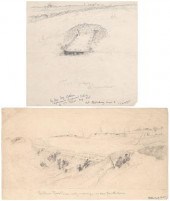 Two James Pattison Civil War
 sketches (James William Pattison, Illinois/Asheville, North Carolina, 1844-1915), both pencil on paper: "The Union Picket Line, early morning…as seen from the Grave", 6-1/8 x 11-1/8 in.; "The Grave at Noontime", inscription verso "And I often stop and wonder/as I ponder on my blunder/why in thunder...lapses/born of languor…us lie", 7-7/8 x 8-3/8 in., both sketches from the Siege of Petersburg, June 15, 1864-April 2, 1865, that led to the surrender of Robert E. Lee (Pattison served in the 57th Regiment, Massachusetts Volunteers, Company G), both unframed. Toning, handling grime, creases, added inscriptions at bottom edges in ink indicating artist and location of subject. Estate of Patricia Pattison Shuttles, Asheville, North Carolina.
Two James Pattison Civil War
Two James Pattison Civil War sketches (James William Pattison, Illinois/Asheville, North Carolina, 1844-1915), both pencil on paper: "The Union Picket Line, early morning…as seen from the Grave", 6-1/8 x 11-1/8 in.; "The Grave at Noontime", inscription verso "And I often stop and wonder/as I ponder on my blunder/why in thunder...lapses/born of languor…us lie", 7-7/8 x 8-3/8 in., both sketches from the Siege of Petersburg, June 15, 1864-April 2, 1865, that led to the surrender of Robert E. Lee (Pattison served in the 57th Regiment, Massachusetts Volunteers, Company G), both unframed. Toning, handling grime, creases, added inscriptions at bottom edges in ink indicating artist and location of subject. Estate of Patricia Pattison Shuttles, Asheville, North Carolina. -
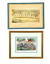
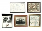 FIVE FRAMED ITEMS. American 2nd
 half-19th century. Two battlefield maps depicting Chickamauga 20''h. 30''w. and Antietam 22''h. 20''w. and a Mother and Sons portrait 24''h. 27''w. Together with two CDVs on a Masonic chromolithograph in a frame 21''h. 27''w. and a framed 24''h 18''w. picture of President Grant's birthplace at Point Pleasant and a post card. Chickamauga map shows heavy creases and some tape repairs.
FIVE FRAMED ITEMS. American 2nd
FIVE FRAMED ITEMS. American 2nd half-19th century. Two battlefield maps depicting Chickamauga 20''h. 30''w. and Antietam 22''h. 20''w. and a Mother and Sons portrait 24''h. 27''w. Together with two CDVs on a Masonic chromolithograph in a frame 21''h. 27''w. and a framed 24''h 18''w. picture of President Grant's birthplace at Point Pleasant and a post card. Chickamauga map shows heavy creases and some tape repairs. -
 Military Maps Illustrating the
 Operations of the Armies of the Potomac & James Office of Chief Engineers 1869 Lot includes 12 (of 17) maps housed in the original mailing tube 30 in. long featuring an old label marked Division of Investigation U.S. Department of Justice Official Business. Michler Nathaniel and John E. Weyss. Military Maps Illustrating the Operations of the Armies of the Potomac & James May 4th 1864 to April 9th 1865 including Battlefields of the Wilderness Spottsylvania [sic] Northanna Totopotomoy Cold Harbor the Siege of Petersburg and Richmond. Battle-fields of Five Forks Jetersville & Sailor's Creek Highbridge Farmville & Appomattox Court-House. Washington: War Department Office of the Chief of Engineers 1869. Begun during the last year of the war many of these maps were rescaled for inclusion in the Atlas that accompanied the Official Records of the Union and Confederate Armies published in the 1890s. Maps present include: Region between Gettysburg and Appomattox Court House Petersburg and Five Forks Jetersville & Sailor's Creek Antietam Bermuda Hundred Spotsylvania Chancellorville Totopotomoy High Bridge & Farmville Cold Harbor Harper's Ferry [sic] The Wilderness Condition: Some a bit rough with margin tears and edge scuffing. Minor water stains. Large tears on the ''title page.''
Military Maps Illustrating the
Military Maps Illustrating the Operations of the Armies of the Potomac & James Office of Chief Engineers 1869 Lot includes 12 (of 17) maps housed in the original mailing tube 30 in. long featuring an old label marked Division of Investigation U.S. Department of Justice Official Business. Michler Nathaniel and John E. Weyss. Military Maps Illustrating the Operations of the Armies of the Potomac & James May 4th 1864 to April 9th 1865 including Battlefields of the Wilderness Spottsylvania [sic] Northanna Totopotomoy Cold Harbor the Siege of Petersburg and Richmond. Battle-fields of Five Forks Jetersville & Sailor's Creek Highbridge Farmville & Appomattox Court-House. Washington: War Department Office of the Chief of Engineers 1869. Begun during the last year of the war many of these maps were rescaled for inclusion in the Atlas that accompanied the Official Records of the Union and Confederate Armies published in the 1890s. Maps present include: Region between Gettysburg and Appomattox Court House Petersburg and Five Forks Jetersville & Sailor's Creek Antietam Bermuda Hundred Spotsylvania Chancellorville Totopotomoy High Bridge & Farmville Cold Harbor Harper's Ferry [sic] The Wilderness Condition: Some a bit rough with margin tears and edge scuffing. Minor water stains. Large tears on the ''title page.'' -
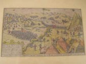
 HAND DRAWN CIVIL WAR MAP, MANASSAS,
 BATTLE OF BULL RUNperiod hand drawn map of first Battle of Bull Run, Virginia, highly detailed in ink, with legend showing "cannon, woods, trenches, roads, r. roads", also illustrated locations for "S.C. N.C. Reg", "dead horses", "hospital", "first man killed", advancement of the "yankee camp", location of dead German-American Union soldiers so labeled "dead Hessians", map and notations reputedly by the hand of Confederate Dr. Joseph Hill present at battle, sight 9-1/2 x 7-1/2 in. Provenance: descended in family; on exhibit at South Carolina State Museum 1969-1994; Private Spartanburg Collection [the_american_south] Condition: light foxing, toning, some thin areas and minor losses at fold intersections, not examined out of frame
HAND DRAWN CIVIL WAR MAP, MANASSAS,
HAND DRAWN CIVIL WAR MAP, MANASSAS, BATTLE OF BULL RUNperiod hand drawn map of first Battle of Bull Run, Virginia, highly detailed in ink, with legend showing "cannon, woods, trenches, roads, r. roads", also illustrated locations for "S.C. N.C. Reg", "dead horses", "hospital", "first man killed", advancement of the "yankee camp", location of dead German-American Union soldiers so labeled "dead Hessians", map and notations reputedly by the hand of Confederate Dr. Joseph Hill present at battle, sight 9-1/2 x 7-1/2 in. Provenance: descended in family; on exhibit at South Carolina State Museum 1969-1994; Private Spartanburg Collection [the_american_south] Condition: light foxing, toning, some thin areas and minor losses at fold intersections, not examined out of frame -
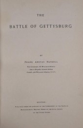 BOOK: BATTLE OF GETTYSBURG,
 LEATHER, 1908The Battle of Gettysburg by Frank Aretas Haskell, published by the Commandery of the State of Massachusetts, Military Order of the Loyal Legion of the United States in 1908. Bound in 3/4 navy leather. Bound in is a typed account of a speech by Harvard University President Charles W. Eliot, given at the 44th Dartmouth Alumni Association Dinner, 1909, in which he praised this book. Signed by Dartmouth Alum "M. B. Jones" to whom the book belonged, per name on ffep. VG+ condition in a handsome binding. shipping info This lot can be shipped in-house.
BOOK: BATTLE OF GETTYSBURG,
BOOK: BATTLE OF GETTYSBURG, LEATHER, 1908The Battle of Gettysburg by Frank Aretas Haskell, published by the Commandery of the State of Massachusetts, Military Order of the Loyal Legion of the United States in 1908. Bound in 3/4 navy leather. Bound in is a typed account of a speech by Harvard University President Charles W. Eliot, given at the 44th Dartmouth Alumni Association Dinner, 1909, in which he praised this book. Signed by Dartmouth Alum "M. B. Jones" to whom the book belonged, per name on ffep. VG+ condition in a handsome binding. shipping info This lot can be shipped in-house. -
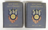 Lot 2 early books ''New York At
 Gettysburg July 1-2-3-1863''.
Lot 2 early books ''New York At
Lot 2 early books ''New York At Gettysburg July 1-2-3-1863''. -
 1 piece. (Judaica.) Printed
 Textile. Pictorial depiction of the Day of Atonement service for German-Jewish soldiers in 1871, in the field during the Franco-Prussian War. N.p., [1871]. Approx. 25 x 27 3/4 inches (635 x 704 mm). Printed in red, sepia & white. Descriptions provided in both printed and on-line catalogue formats do not include condition reports. The absence of a condition statement does not imply that the lot is in perfect condition or completely free from wear and tear, imperfections or the effects of aging. Interested bidders are strongly encouraged to request a condition report on any lots upon which they intend to bid, prior to placing a bid. All transactions are governed by Freeman''s Conditions of Sale.
1 piece. (Judaica.) Printed
1 piece. (Judaica.) Printed Textile. Pictorial depiction of the Day of Atonement service for German-Jewish soldiers in 1871, in the field during the Franco-Prussian War. N.p., [1871]. Approx. 25 x 27 3/4 inches (635 x 704 mm). Printed in red, sepia & white. Descriptions provided in both printed and on-line catalogue formats do not include condition reports. The absence of a condition statement does not imply that the lot is in perfect condition or completely free from wear and tear, imperfections or the effects of aging. Interested bidders are strongly encouraged to request a condition report on any lots upon which they intend to bid, prior to placing a bid. All transactions are governed by Freeman''s Conditions of Sale. -
 Civil War Stereo Views
 "Photographic History - War for the Union", series published by E & H.T. Anthony & Co., New York, 1865, after Brady, 32 stereo views on yellow mounts, images include Union officers, living and deceased soldiers, battle sites, forts and other buildings, fortifications and earthworks, southern views in Virginia, South Carolina, Tennessee and Georgia, one view of General Grant and family signed verso by his son, Frederick Grant, all with paper labels verso describing scene, each approximately 3-1/4 x 6-3/4 in.; detailed listing: #1994: Aqueduct Bridge above Georgetown, on the Potomac. Government Vessels and Canal boats filled with Stores, escaping the Raiders, July 12, 1864.#2296: Slave Pen, Alexandria, Va.#2330: Hanover Junction, 20 miles from Richmond; a point of note in McClellan’s and Grant’s Campaigns.#2365: Fortifications near Yorktown, Va.#2428: Lieut. Gen. Grant and chief of staff, Gen. Rawlins, at his Head Quarters, at Cold Harbor, Va. Taken June 14th, 1864.#2432: Group of Generals: Hancock, Birney, Gibbon and Barlow, in the field, near Richmond, Va.#2549: Gen. Butlers’ Dutch Gap Canal. In the centre is a dam to keep out the water, and passage way for workmen; on the left is a railroad track for drawing out the dirt; in the foreground a mud scow.#2590: Gen. Grant’s favorite filed horse Cincinnati. Taken at City Point, Va.#2591: Jeff. Davis, one of Gen. Grant’s saddle horses. Taken at City Point, Va.#2610: Dutch Gap Canal and Group of Soldiers. Taken after the bank was blown out. On the extreme end a portion of the bank remains, which forms a profile, which the soldiers call Jeff. Davis.#2691: Gun boat Kansas. Officers in the foreground. James River, Va.#3094: Group of Relics in Charleston, SC, Arsenal, showing Rebel torpedoes, shot, shell, and breach of the 600 lb. Blakely Gun.#3103: Broad St., Charleston SC, looking East, with the ruins of the Roman Catholic Cathedral and St. Michael’s church in the distance.#3127: Fort Sumpter, east face, Charleston Harbor, SC showing the Palmetto Works erected to strengthen the fort.#3139: Interior of Fort Sumpter, Charleston Harbor, Sc, April 14th, 1865, pending the ceremony of raising the old Flag.#3175: A Dead Rebel Soldier, as he lay in the Treches of Fort Mahone, called by the Soldiers “Fort Damnation.” The View was taken the Morning after the storming of Petersburgh, Va., April 2d, 1865.#3177: C.S. Soldier killed by a shell in the Trenches of Fort Mahone, called by the Soldiers “Fort Damnation.” This View was taken the morning after the storming of Petersburgh, Va., April 2d, 1865.#3182: Rebel Soldiers killed in the Trenches of Fort Mahone, called by the Soldiers “Fort Damnation.” The view shows the construction of their Bomb Proofs and Covered passages, which branch off in every direction. Taken the morning after the storming of Petersburgh, Va., April 2d, 1865.#3183: This Picture is a good view of the Covered Ways inside the Rebel Fort Mahone, called by the Soldiers “Fort Damnation.” The Union Soldiers had to charge up and down these obstructions. In the foreground centre is a dead Rebel Soldier sticking out through the debris, and further on lies another Confederate Soldier. This View was taken the morning after the storming of Petersburgh, Va., April 2d, 1865.#3184: Rebel Soldier killed in the Trenches of Fort Mahone, called by the Soldiers “Fort Damnation.” This View was taken the morning after the storming of Petersburgh, Va., April 2d, 1865.#3192: Chevaux de fries, and breast works in the Union Fort Sedgwick, called by the Rebels “Fort Hell,” showing two wounded soldiers. This view was made the morning after the storming of Petersburgh, Va., April 2d, 1865.#3198: Rebel Prisoners on their way to the rear, captured by Gen. Sheriden at Five Forks April 3d 1865. This View was taken April 3d, after the storming of Petersburgh, Va.#3243: Ruins in the burnt district, from the Petersburgh railroad Depot, showing a portion of the Arsenal grounds, Richmond, Va.#3285: Park of Captured Guns at Rocketts, Richmond, Va.#3362: “Castle Thunder,” Cary St., the place where so many Union prisoners suffered. Richmond, Va.#3288: Residence of Gen. Robert E. Lee, Franklin St., Richmond, Va.#3365: Libby Prison, Richmond, Va.#3366: St. John’s Church, Church Hill, Richmond, Va. This church is the place where Patrick Henry made his immortal speech. #3376: Mansion occupied by Jeff. Davis, during the Rebellion, cor. Clay and Twelfth St. Richmond, Va.#3399: Lieut. Gen. Grant, Wife and Son at his Head Quarters, City Point, Va. (signed)#3624: Maj. Gen. W. T. Sherman and Horse. This View was taken in the Trenches before Atlanta, Ga.#3652: Lulu Falls, on top of Lookout Mountain, Tenn.
Civil War Stereo Views
Civil War Stereo Views "Photographic History - War for the Union", series published by E & H.T. Anthony & Co., New York, 1865, after Brady, 32 stereo views on yellow mounts, images include Union officers, living and deceased soldiers, battle sites, forts and other buildings, fortifications and earthworks, southern views in Virginia, South Carolina, Tennessee and Georgia, one view of General Grant and family signed verso by his son, Frederick Grant, all with paper labels verso describing scene, each approximately 3-1/4 x 6-3/4 in.; detailed listing: #1994: Aqueduct Bridge above Georgetown, on the Potomac. Government Vessels and Canal boats filled with Stores, escaping the Raiders, July 12, 1864.#2296: Slave Pen, Alexandria, Va.#2330: Hanover Junction, 20 miles from Richmond; a point of note in McClellan’s and Grant’s Campaigns.#2365: Fortifications near Yorktown, Va.#2428: Lieut. Gen. Grant and chief of staff, Gen. Rawlins, at his Head Quarters, at Cold Harbor, Va. Taken June 14th, 1864.#2432: Group of Generals: Hancock, Birney, Gibbon and Barlow, in the field, near Richmond, Va.#2549: Gen. Butlers’ Dutch Gap Canal. In the centre is a dam to keep out the water, and passage way for workmen; on the left is a railroad track for drawing out the dirt; in the foreground a mud scow.#2590: Gen. Grant’s favorite filed horse Cincinnati. Taken at City Point, Va.#2591: Jeff. Davis, one of Gen. Grant’s saddle horses. Taken at City Point, Va.#2610: Dutch Gap Canal and Group of Soldiers. Taken after the bank was blown out. On the extreme end a portion of the bank remains, which forms a profile, which the soldiers call Jeff. Davis.#2691: Gun boat Kansas. Officers in the foreground. James River, Va.#3094: Group of Relics in Charleston, SC, Arsenal, showing Rebel torpedoes, shot, shell, and breach of the 600 lb. Blakely Gun.#3103: Broad St., Charleston SC, looking East, with the ruins of the Roman Catholic Cathedral and St. Michael’s church in the distance.#3127: Fort Sumpter, east face, Charleston Harbor, SC showing the Palmetto Works erected to strengthen the fort.#3139: Interior of Fort Sumpter, Charleston Harbor, Sc, April 14th, 1865, pending the ceremony of raising the old Flag.#3175: A Dead Rebel Soldier, as he lay in the Treches of Fort Mahone, called by the Soldiers “Fort Damnation.” The View was taken the Morning after the storming of Petersburgh, Va., April 2d, 1865.#3177: C.S. Soldier killed by a shell in the Trenches of Fort Mahone, called by the Soldiers “Fort Damnation.” This View was taken the morning after the storming of Petersburgh, Va., April 2d, 1865.#3182: Rebel Soldiers killed in the Trenches of Fort Mahone, called by the Soldiers “Fort Damnation.” The view shows the construction of their Bomb Proofs and Covered passages, which branch off in every direction. Taken the morning after the storming of Petersburgh, Va., April 2d, 1865.#3183: This Picture is a good view of the Covered Ways inside the Rebel Fort Mahone, called by the Soldiers “Fort Damnation.” The Union Soldiers had to charge up and down these obstructions. In the foreground centre is a dead Rebel Soldier sticking out through the debris, and further on lies another Confederate Soldier. This View was taken the morning after the storming of Petersburgh, Va., April 2d, 1865.#3184: Rebel Soldier killed in the Trenches of Fort Mahone, called by the Soldiers “Fort Damnation.” This View was taken the morning after the storming of Petersburgh, Va., April 2d, 1865.#3192: Chevaux de fries, and breast works in the Union Fort Sedgwick, called by the Rebels “Fort Hell,” showing two wounded soldiers. This view was made the morning after the storming of Petersburgh, Va., April 2d, 1865.#3198: Rebel Prisoners on their way to the rear, captured by Gen. Sheriden at Five Forks April 3d 1865. This View was taken April 3d, after the storming of Petersburgh, Va.#3243: Ruins in the burnt district, from the Petersburgh railroad Depot, showing a portion of the Arsenal grounds, Richmond, Va.#3285: Park of Captured Guns at Rocketts, Richmond, Va.#3362: “Castle Thunder,” Cary St., the place where so many Union prisoners suffered. Richmond, Va.#3288: Residence of Gen. Robert E. Lee, Franklin St., Richmond, Va.#3365: Libby Prison, Richmond, Va.#3366: St. John’s Church, Church Hill, Richmond, Va. This church is the place where Patrick Henry made his immortal speech. #3376: Mansion occupied by Jeff. Davis, during the Rebellion, cor. Clay and Twelfth St. Richmond, Va.#3399: Lieut. Gen. Grant, Wife and Son at his Head Quarters, City Point, Va. (signed)#3624: Maj. Gen. W. T. Sherman and Horse. This View was taken in the Trenches before Atlanta, Ga.#3652: Lulu Falls, on top of Lookout Mountain, Tenn. -
 TWO HANDCOLORED LITHOGRAPHS.
 American 1860s. Battle of Bull Run... by Currier & Ives C# 391. In a mat and frame 17 1/4''h. 21 1/4''w. And Camp Belder Baltimore Md by E. Sachse. Stains and tears. In a frame 15 3/4''h. 21 3/4''w.
TWO HANDCOLORED LITHOGRAPHS.
TWO HANDCOLORED LITHOGRAPHS. American 1860s. Battle of Bull Run... by Currier & Ives C# 391. In a mat and frame 17 1/4''h. 21 1/4''w. And Camp Belder Baltimore Md by E. Sachse. Stains and tears. In a frame 15 3/4''h. 21 3/4''w.
...many more examples with full details are available to our members - Learn more
Easy & Visual methods to Identify & Appraise Antiques & Collectibles
EASY. FAST. ACCURATE.
Research at its best
We are here to help!
Our research tools include:

Thousands of makers marks for PORCELAIN, POTTERY CHINAWARE, FIGURINES, VASES
see details...

Thousands of marks & hallmarks for SILVER & JEWELRY, PEWTER, PRECIOUS METALS, SILVERPLATE
see details...
