Pricing Guides & Dictionary of Makers Marks for Antiques & Collectibles
A few examples of appraisal values for
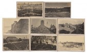
BEAUFORT
Search our price guide for your own treasures
-
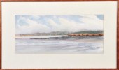
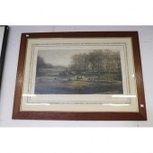
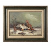 BEAUFORT: BELGIAN LANDSCAPEoil on
 canvas; signed "Beaufort" lower right; 12 x 16 inches; 17 1/2 x 21 1/2 inches frame Condition:
BEAUFORT: BELGIAN LANDSCAPEoil on
BEAUFORT: BELGIAN LANDSCAPEoil on canvas; signed "Beaufort" lower right; 12 x 16 inches; 17 1/2 x 21 1/2 inches frame Condition: -
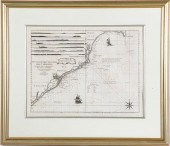
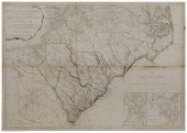
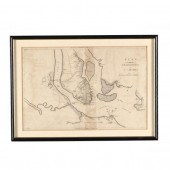
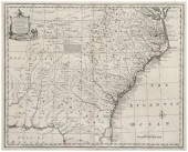
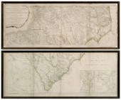
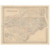 ANTEBELLUM MAP, NORTH CAROLINA (New
 York: J. H. Colton & Co., 1855), steel engraving with color, inset plan showing the port of Beaufort; presented behind mat in wooden frame.
ANTEBELLUM MAP, NORTH CAROLINA (New
ANTEBELLUM MAP, NORTH CAROLINA (New York: J. H. Colton & Co., 1855), steel engraving with color, inset plan showing the port of Beaufort; presented behind mat in wooden frame. -
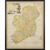
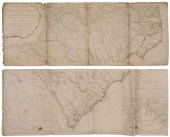
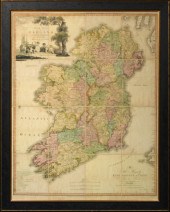 The Reverend Daniel Augustus
 Beaufort, R. A. (Irish, 1739-1821), "A New Map of Ireland, Civil and Ecclesiastical", the second edition of 1797, William Faden, London, engraved by Samuel John Neele (1758-1824), on sixteen sheets laid down on linen, sight 53-1/4" x 43", presented in an ebonized frame with gilt trim and glazed, 63" x 50".
The Reverend Daniel Augustus
The Reverend Daniel Augustus Beaufort, R. A. (Irish, 1739-1821), "A New Map of Ireland, Civil and Ecclesiastical", the second edition of 1797, William Faden, London, engraved by Samuel John Neele (1758-1824), on sixteen sheets laid down on linen, sight 53-1/4" x 43", presented in an ebonized frame with gilt trim and glazed, 63" x 50". -
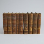 Henry Somerset, 8th Duke of
 Beaufort (British, 1824-1899) (Editor) THE BADMINTON LIBRARY OF SPORTS AND PASTIMES THE BADMINTON LIBRARY OF SPORTS AND PASTIMES
Henry Somerset, 8th Duke of
Henry Somerset, 8th Duke of Beaufort (British, 1824-1899) (Editor) THE BADMINTON LIBRARY OF SPORTS AND PASTIMES THE BADMINTON LIBRARY OF SPORTS AND PASTIMES -
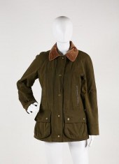 BARBOUR BEAUFORT JACKETAuthentic
 Barbour Beaufort waxed green cotton jacket, zipper and snap closure, Barbour tartan wool lining, women's size 8, some minor marks from wear
BARBOUR BEAUFORT JACKETAuthentic
BARBOUR BEAUFORT JACKETAuthentic Barbour Beaufort waxed green cotton jacket, zipper and snap closure, Barbour tartan wool lining, women's size 8, some minor marks from wear -
 West Fraser (South Carolina b.
 1955) DAUFUSKIE ISLAND SOUTH CAROLINA watercolor framed signed dated & located: lower right 1981 sight size: H9'' W20 1/2'' Provenance: Beaufort South Carolina private collection. Other Notes: Verso bearing Joe DeMers Gallery Hilton Head Island label.
West Fraser (South Carolina b.
West Fraser (South Carolina b. 1955) DAUFUSKIE ISLAND SOUTH CAROLINA watercolor framed signed dated & located: lower right 1981 sight size: H9'' W20 1/2'' Provenance: Beaufort South Carolina private collection. Other Notes: Verso bearing Joe DeMers Gallery Hilton Head Island label. -
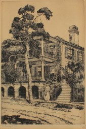
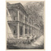 LOUIS ORR (AMERICAN, 1879-1961),
 DAVIS HOUSE, 18TH CENTURY TAVERN, BEAUFORT, NORTH CAROLINA Etching, pencil signed and titled "Davis Tavern, Beaufort, North Carolina," from Orr's series of North Carolina landmarks completed between 1939-1952, matted and framed.
LOUIS ORR (AMERICAN, 1879-1961),
LOUIS ORR (AMERICAN, 1879-1961), DAVIS HOUSE, 18TH CENTURY TAVERN, BEAUFORT, NORTH CAROLINA Etching, pencil signed and titled "Davis Tavern, Beaufort, North Carolina," from Orr's series of North Carolina landmarks completed between 1939-1952, matted and framed. -
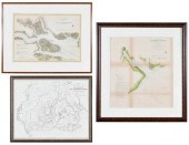 THREE SOUTH CAROLINA
 MAPSPreliminary Chart of Port Royal Entrance, Beaufort Chechessee and Colleton Rivers... U.S. Coast Survey Office, Superintendent A. D. Bache, triangulation by C. O. Boutelle... 1859, single sheet, engraving on wove paper, hand colored highlights, with tidal observations and sailing directions, sight 22-1/4 x 25-1/2 in.; Entrance to Bull and Combahee Rivers... U.S. Coast Survey Office, Superintendent Benjamin Pierce, 1871, single sheet, engraving on wove paper, hand colored highlights, with soundings, lighthouse, and tidal observations, sight 16 x 22-1/2 in.; reproduction Map showing the location of the lands of the South Carolina Land and Improvement Company on Port Royal Harbor , G.W. and C.B. Colton & Co., New York, 1877, sight 16 x 22-3/8 in.; largest frame 35-7/8 x 32-1/2 in. Provenance: Private Bluffton, South Carolina Collection Condition: not examined out of frames, scattered areas of toning, light staining, and handling creases throughout; Port Royal Entrance with handling creases, separation along one fold line, tear to upper left corner; frames with light wear and abrasions; Bull and Combahee Rivers frame separating at lower right corner
THREE SOUTH CAROLINA
THREE SOUTH CAROLINA MAPSPreliminary Chart of Port Royal Entrance, Beaufort Chechessee and Colleton Rivers... U.S. Coast Survey Office, Superintendent A. D. Bache, triangulation by C. O. Boutelle... 1859, single sheet, engraving on wove paper, hand colored highlights, with tidal observations and sailing directions, sight 22-1/4 x 25-1/2 in.; Entrance to Bull and Combahee Rivers... U.S. Coast Survey Office, Superintendent Benjamin Pierce, 1871, single sheet, engraving on wove paper, hand colored highlights, with soundings, lighthouse, and tidal observations, sight 16 x 22-1/2 in.; reproduction Map showing the location of the lands of the South Carolina Land and Improvement Company on Port Royal Harbor , G.W. and C.B. Colton & Co., New York, 1877, sight 16 x 22-3/8 in.; largest frame 35-7/8 x 32-1/2 in. Provenance: Private Bluffton, South Carolina Collection Condition: not examined out of frames, scattered areas of toning, light staining, and handling creases throughout; Port Royal Entrance with handling creases, separation along one fold line, tear to upper left corner; frames with light wear and abrasions; Bull and Combahee Rivers frame separating at lower right corner -
 IRELAND [MAP] - BEAUFORT, THE
 REVEREND DANIEL AUGUSTUS SECOND EDITION, 1797 "A New Map of Ireland, Civil and Ecclesiastical", William Faden, London, engraved by Samuel John Neele (1758-1824), hand-coloured and dissected on sixteen sheets laid down on linen, in an ebonized glazed frame 98cm x 85.5cm sight sizeProvenance: The Bellamy Collection, County Down, Northern Ireland
IRELAND [MAP] - BEAUFORT, THE
IRELAND [MAP] - BEAUFORT, THE REVEREND DANIEL AUGUSTUS SECOND EDITION, 1797 "A New Map of Ireland, Civil and Ecclesiastical", William Faden, London, engraved by Samuel John Neele (1758-1824), hand-coloured and dissected on sixteen sheets laid down on linen, in an ebonized glazed frame 98cm x 85.5cm sight sizeProvenance: The Bellamy Collection, County Down, Northern Ireland -
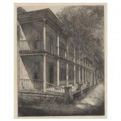 LOUIS ORR (AMERICAN, 1879-1961),
 DAVIS HOUSE, 18TH CENTURY TAVERN, BEAUFORT, NORTH CAROLINA Etching, pencil signed and titled "18th-Century Tavern, The Davis House, Beaufort, North Carolina," from Orr's series of North Carolina landmarks completed between 1939-1952, matted and framed.
LOUIS ORR (AMERICAN, 1879-1961),
LOUIS ORR (AMERICAN, 1879-1961), DAVIS HOUSE, 18TH CENTURY TAVERN, BEAUFORT, NORTH CAROLINA Etching, pencil signed and titled "18th-Century Tavern, The Davis House, Beaufort, North Carolina," from Orr's series of North Carolina landmarks completed between 1939-1952, matted and framed. -
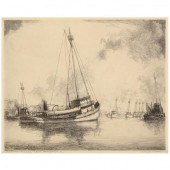 LOUIS ORR (AMERICAN, 1879-1961),
 MENHADEN FISHING FLEET, BEAUFORT, NORTH CAROLINA Etching, pencil signed and titled, from Orr's series of North Carolina landmarks completed between 1939-1952, matted and framed.
LOUIS ORR (AMERICAN, 1879-1961),
LOUIS ORR (AMERICAN, 1879-1961), MENHADEN FISHING FLEET, BEAUFORT, NORTH CAROLINA Etching, pencil signed and titled, from Orr's series of North Carolina landmarks completed between 1939-1952, matted and framed. -
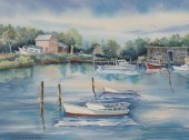 SUSAN B. SCHUHMACHER (AMERICAN,
 20TH CENTURY) 18" x 24 ½" sight size "Beaufort". Watercolor on Arches paper, signed lower right, in a metallic frame with white mat, overall 34 ½" x 28 ¼". Provenance: from the art collection of an international corporation.
SUSAN B. SCHUHMACHER (AMERICAN,
SUSAN B. SCHUHMACHER (AMERICAN, 20TH CENTURY) 18" x 24 ½" sight size "Beaufort". Watercolor on Arches paper, signed lower right, in a metallic frame with white mat, overall 34 ½" x 28 ¼". Provenance: from the art collection of an international corporation. -
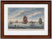
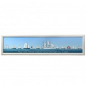 ALAN CHEEK (AMERICAN), TALL SHIPS
 PARADE THROUGH BEAUFORT INLET JULY 1. 2006 Giclée on canvas, signed and numbered edition 3/200, labeled to verso, framed.
ALAN CHEEK (AMERICAN), TALL SHIPS
ALAN CHEEK (AMERICAN), TALL SHIPS PARADE THROUGH BEAUFORT INLET JULY 1. 2006 Giclée on canvas, signed and numbered edition 3/200, labeled to verso, framed. -
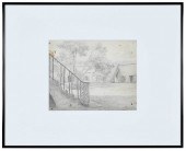 LOUIS ORR(American, 1879-1961) Fort
 Macon, Beaufort Harbor, signed lower left "Louis Orr", inscribed verso "Fort Macon - Beaufort Harbor", graphite on paper, sight 8 x 10 in.; gallery style black metal frame, 20-1/4 x 16-1/4 in. Provenance: Humber Family, North Carolina Note: This original drawing served as the basis for one of the 51 etchings completed by Louis Orr depicting views of North Carolina. The project was conceived and underwritten by Robert Lee Humber as a way to preserve the landscape of North Carolina and provide affordable original artwork to schools, institutions, and individuals. Condition: archivally hinged into acid free mat, not examined out of frame, paper slightly darkened, small specks of discoloration scattered over surface, tape residue verso; frame with light wear
LOUIS ORR(American, 1879-1961) Fort
LOUIS ORR(American, 1879-1961) Fort Macon, Beaufort Harbor, signed lower left "Louis Orr", inscribed verso "Fort Macon - Beaufort Harbor", graphite on paper, sight 8 x 10 in.; gallery style black metal frame, 20-1/4 x 16-1/4 in. Provenance: Humber Family, North Carolina Note: This original drawing served as the basis for one of the 51 etchings completed by Louis Orr depicting views of North Carolina. The project was conceived and underwritten by Robert Lee Humber as a way to preserve the landscape of North Carolina and provide affordable original artwork to schools, institutions, and individuals. Condition: archivally hinged into acid free mat, not examined out of frame, paper slightly darkened, small specks of discoloration scattered over surface, tape residue verso; frame with light wear -
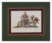 HAND-COLORED ENGRAVING OF THE
 BEAUFORT FAMILY CREST 19TH CENTURY 4.75” X 6.75” SIGHT . MATTED 8.75” X 10.75”.HAND-COLORED ENGRAVING OF THE BEAUFORT FAMILY CREST, 19th Century, Dimensions: 4.75" x 6.75" sight . Matted 8.75" x 10.75".
HAND-COLORED ENGRAVING OF THE
HAND-COLORED ENGRAVING OF THE BEAUFORT FAMILY CREST 19TH CENTURY 4.75” X 6.75” SIGHT . MATTED 8.75” X 10.75”.HAND-COLORED ENGRAVING OF THE BEAUFORT FAMILY CREST, 19th Century, Dimensions: 4.75" x 6.75" sight . Matted 8.75" x 10.75". -
 Coastal map of the Carolinas by
 George Louis Le Rouge Paris circa 1777 NOUVELLE CARTE DES COTES DES CAROLINES SEPTENTRIONALES ET MERIDIONALES DU CAP FEAR A SUD EDISTO as published in ATLAS AMERIQUAIN SEPTENTRIONALE. Matted framed and uncolored. plate size: H16 1/2'' W21 1/2'' Provenance: Columbia South Carolina private collection. Good overall condition; hinged at top with tape; light matteburning; few small and light spots of discoloration; center crease.
Coastal map of the Carolinas by
Coastal map of the Carolinas by George Louis Le Rouge Paris circa 1777 NOUVELLE CARTE DES COTES DES CAROLINES SEPTENTRIONALES ET MERIDIONALES DU CAP FEAR A SUD EDISTO as published in ATLAS AMERIQUAIN SEPTENTRIONALE. Matted framed and uncolored. plate size: H16 1/2'' W21 1/2'' Provenance: Columbia South Carolina private collection. Good overall condition; hinged at top with tape; light matteburning; few small and light spots of discoloration; center crease. -
 Henry Mouzon Map of the Carolinas
 "An Accurate Map of North and South Carolina with their Indian Frontiers?", published by Sawyer and Bennett, London, 1775, showing the coastal areas of the Carolinas extending west to the Appalachian mountains, "Harbour of Port Royal" and "Bar and Harbour of Charleston", vignettes in lower corners, two joined sections composed of four sheets, some boundaries and rivers with hand-colored outlines, 41-1/4 x 57-3/4 in. overall; modern wood frame,
Henry Mouzon Map of the Carolinas
Henry Mouzon Map of the Carolinas "An Accurate Map of North and South Carolina with their Indian Frontiers?", published by Sawyer and Bennett, London, 1775, showing the coastal areas of the Carolinas extending west to the Appalachian mountains, "Harbour of Port Royal" and "Bar and Harbour of Charleston", vignettes in lower corners, two joined sections composed of four sheets, some boundaries and rivers with hand-colored outlines, 41-1/4 x 57-3/4 in. overall; modern wood frame, -
 Henry Mouzon Map of the Carolinas
 "An Accurate Map of North and South Carolina with their Indian Frontiers…", published by Sawyer and Bennett, London, 1775, showing the coastal areas of the Carolinas extending west to the Appalachian Mountains, "Harbour of Port Royal" and "Bar and Harbour of Charlestown" vignettes in lower corners, two unjoined sections each consisting of four pages, lower sheet with watermarks and "24" ink stamp verso, laid paper with some hand-colored outlines, upper sheet 21-1/2 x 54-3/4 in. (page), lower sheet 21-1/4 x 52-1/4 in. (page),
Henry Mouzon Map of the Carolinas
Henry Mouzon Map of the Carolinas "An Accurate Map of North and South Carolina with their Indian Frontiers…", published by Sawyer and Bennett, London, 1775, showing the coastal areas of the Carolinas extending west to the Appalachian Mountains, "Harbour of Port Royal" and "Bar and Harbour of Charlestown" vignettes in lower corners, two unjoined sections each consisting of four pages, lower sheet with watermarks and "24" ink stamp verso, laid paper with some hand-colored outlines, upper sheet 21-1/2 x 54-3/4 in. (page), lower sheet 21-1/4 x 52-1/4 in. (page), -
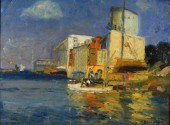 ARTHUR BEAUMONT IMPRESSIONIST
 HARBOR O/B PAINTING New York,1877-1956Coastal seascape depicting a fishing harbor with two boats and several figures in the foreground with a nicely mottled reflection. The artist began a landscape on the verso.
ARTHUR BEAUMONT IMPRESSIONIST
ARTHUR BEAUMONT IMPRESSIONIST HARBOR O/B PAINTING New York,1877-1956Coastal seascape depicting a fishing harbor with two boats and several figures in the foreground with a nicely mottled reflection. The artist began a landscape on the verso. -
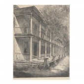 LOUIS ORR (AMERICAN, 1879-1961),
 DAVIS HOUSE, 18TH CENTURY TAVERN, BEAUFORT, NORTH CAROLINA Etching, pencil signed and titled, from Orr's series of North Carolina landmarks completed between 1939-1952, matted and framed.
LOUIS ORR (AMERICAN, 1879-1961),
LOUIS ORR (AMERICAN, 1879-1961), DAVIS HOUSE, 18TH CENTURY TAVERN, BEAUFORT, NORTH CAROLINA Etching, pencil signed and titled, from Orr's series of North Carolina landmarks completed between 1939-1952, matted and framed. -
 Antique coloured print, The Duke of
 Beauforts- going to the meet Badminton Published 1911
Antique coloured print, The Duke of
Antique coloured print, The Duke of Beauforts- going to the meet Badminton Published 1911 -
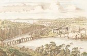
 Revolutionary map, Charleston
 Harbor, "A Birds Eye View from part of Mount Pleasant…" by William Faden (1750-1836), London, 1776, showing panoramic view of islands in Charleston Harbor including fortifications, encampments, and a legend detailing various points of interest in the battle, copper engraving on laid paper, page 9-1/2 x 25-1/2 in.; modern wood frame. Loose, toning, minor foxing, fading, creases, 1/2 in. tear in upper margin, several minor repaired losses within plate area, pencil and ink inscriptions verso; frame with abrasions. Deaccessioned from MESDA and Old Salem to benefit the Acquisition Fund.
Revolutionary map, Charleston
Revolutionary map, Charleston Harbor, "A Birds Eye View from part of Mount Pleasant…" by William Faden (1750-1836), London, 1776, showing panoramic view of islands in Charleston Harbor including fortifications, encampments, and a legend detailing various points of interest in the battle, copper engraving on laid paper, page 9-1/2 x 25-1/2 in.; modern wood frame. Loose, toning, minor foxing, fading, creases, 1/2 in. tear in upper margin, several minor repaired losses within plate area, pencil and ink inscriptions verso; frame with abrasions. Deaccessioned from MESDA and Old Salem to benefit the Acquisition Fund. -
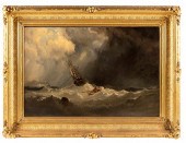
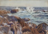
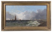 ALFRED MONTAGUE (UK, 1832-1883)
 "A Showery Day Off Portsmouth", the high waves crowded by ships and boats with figures on the beach to the right, housed in a beaded cove gilt frame, OS: 16 1/2" x 27 1/2", SS: 11 1/2" x 22 1/2", cleaned and relined.
ALFRED MONTAGUE (UK, 1832-1883)
ALFRED MONTAGUE (UK, 1832-1883) "A Showery Day Off Portsmouth", the high waves crowded by ships and boats with figures on the beach to the right, housed in a beaded cove gilt frame, OS: 16 1/2" x 27 1/2", SS: 11 1/2" x 22 1/2", cleaned and relined. -
 MAP, PLAN OF THE SIEGE OF
 CHARLESTON IN SOUTH CAROLINA From John Marshall's The Life of George Washington (Philadelphia: C. P. Wayne, 1807), depicting the deployment of British forces around the port city prior to its inevitable capture. Presented in a black wooden frame with gilt liner, the back with 1964 label for framer Ferd Hoch Co., Somerville, NJ.
MAP, PLAN OF THE SIEGE OF
MAP, PLAN OF THE SIEGE OF CHARLESTON IN SOUTH CAROLINA From John Marshall's The Life of George Washington (Philadelphia: C. P. Wayne, 1807), depicting the deployment of British forces around the port city prior to its inevitable capture. Presented in a black wooden frame with gilt liner, the back with 1964 label for framer Ferd Hoch Co., Somerville, NJ. -
 ARTHUR JAMES BEAUMONT (American
 1877 - 1956). COASTAL TOWN signed lower right. Oil on board - Framed 6 in. x 9 in.
ARTHUR JAMES BEAUMONT (American
ARTHUR JAMES BEAUMONT (American 1877 - 1956). COASTAL TOWN signed lower right. Oil on board - Framed 6 in. x 9 in. -
 E.F. BEAULIEU (NEW YORK, 19TH
 CENTURY), A SHIP BATTLING STRORMY SEAS., OIL ON CANVAS, 20" X 30". FRAMED 29" X 39".E.F. BEAULIEU, New York, 19th Century, A ship battling strormy seas. Signed lower right "E.F. Beaulieu N.Y.". Dimensions: Oil on canvas, 20" x 30". Framed 29" x 39".
E.F. BEAULIEU (NEW YORK, 19TH
E.F. BEAULIEU (NEW YORK, 19TH CENTURY), A SHIP BATTLING STRORMY SEAS., OIL ON CANVAS, 20" X 30". FRAMED 29" X 39".E.F. BEAULIEU, New York, 19th Century, A ship battling strormy seas. Signed lower right "E.F. Beaulieu N.Y.". Dimensions: Oil on canvas, 20" x 30". Framed 29" x 39". -
 Locke Walter Ronald (American
 1883 - ?): ''In Beaufort S.C.'' Limited Edition Original Etching sight size 13'' x 8 3/4'' pencil signed lower right dated '39 titled lower left original AAA Label affixed verso encased in ordinal black frame with wear 18 1/2'' x 14 1/2'' the scene depicts a young African American woman walking in front of an old plantation.CONDITION: Some toning and browning along the mat edges not examined out of the frame.
Locke Walter Ronald (American
Locke Walter Ronald (American 1883 - ?): ''In Beaufort S.C.'' Limited Edition Original Etching sight size 13'' x 8 3/4'' pencil signed lower right dated '39 titled lower left original AAA Label affixed verso encased in ordinal black frame with wear 18 1/2'' x 14 1/2'' the scene depicts a young African American woman walking in front of an old plantation.CONDITION: Some toning and browning along the mat edges not examined out of the frame. -
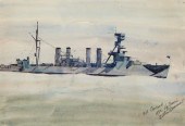 ARTHUR BEAUMONT (1890-1978), "USS
 CONCORD," 1932, WATERCOLOR ON PAPER, SIGHT: 9.625" H X 14" WArthur Beaumont, (1890-1978) "USS Concord," 1932, Watercolor on paper Signed, titled, dated, and inscribed lower right: Arthur Beaumont / Lg Beach Watercolor on paper Dimensions: Sight: 9.625" H x 14" W Provenance: Jonathan Art Foundation, Los Angeles, CA
ARTHUR BEAUMONT (1890-1978), "USS
ARTHUR BEAUMONT (1890-1978), "USS CONCORD," 1932, WATERCOLOR ON PAPER, SIGHT: 9.625" H X 14" WArthur Beaumont, (1890-1978) "USS Concord," 1932, Watercolor on paper Signed, titled, dated, and inscribed lower right: Arthur Beaumont / Lg Beach Watercolor on paper Dimensions: Sight: 9.625" H x 14" W Provenance: Jonathan Art Foundation, Los Angeles, CA -
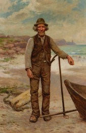 CHARLES BEAUREGARD FISHERMAN
 PORTRAIT PAITING Charles Grant BeauregardNew York, Quebec, Canada,1856-1919Realist portrait depicting an old salt on the beach leaning on an anchor smoking a pipe next to a wood rowboat with the ocean in the background.Oil on canvasSigned "C. G. Beauregard" and dated "1897" lower left.Canvas 25" x 16 1/2',Frame 33" x 24"From a Harrisville, Rhode Island gentleman.
CHARLES BEAUREGARD FISHERMAN
CHARLES BEAUREGARD FISHERMAN PORTRAIT PAITING Charles Grant BeauregardNew York, Quebec, Canada,1856-1919Realist portrait depicting an old salt on the beach leaning on an anchor smoking a pipe next to a wood rowboat with the ocean in the background.Oil on canvasSigned "C. G. Beauregard" and dated "1897" lower left.Canvas 25" x 16 1/2',Frame 33" x 24"From a Harrisville, Rhode Island gentleman. -
 E. Bowen 18th century map,
 Southeast, "A New & Accurate Map of the Provinces of North & South Carolina Georgia & C." by Emmanuel Bowen, showing towns, forts, Indian tribes, and geographical features just prior to the French and Indian War, with annotation describing the Cherokee Indians as "A Numerous and Warlike Nation…", from Bowen's Complete System of Geography…", published by W. Innys, et al., London, 1747, copper engraving on laid paper, 16-1/2 x 19-1/4 in. (page). Loose, folds, creases, toning, reinforced center crease, several minor tears, 5 in. repaired tears at bottom, fabric tape verso.
E. Bowen 18th century map,
E. Bowen 18th century map, Southeast, "A New & Accurate Map of the Provinces of North & South Carolina Georgia & C." by Emmanuel Bowen, showing towns, forts, Indian tribes, and geographical features just prior to the French and Indian War, with annotation describing the Cherokee Indians as "A Numerous and Warlike Nation…", from Bowen's Complete System of Geography…", published by W. Innys, et al., London, 1747, copper engraving on laid paper, 16-1/2 x 19-1/4 in. (page). Loose, folds, creases, toning, reinforced center crease, several minor tears, 5 in. repaired tears at bottom, fabric tape verso. -
 Johannes Kip/Chepstow Castle,
 belonging to His Grace the Duke of Beaufort/hand coloured engraving, 33.5cm x 43cm and Deeley (J. publisher) Chepstow Castle Monmouthshire, Oct. 1st. 1812/aquatint with hand colouring, 37cm x 51.5cm
Johannes Kip/Chepstow Castle,
Johannes Kip/Chepstow Castle, belonging to His Grace the Duke of Beaufort/hand coloured engraving, 33.5cm x 43cm and Deeley (J. publisher) Chepstow Castle Monmouthshire, Oct. 1st. 1812/aquatint with hand colouring, 37cm x 51.5cm -
 18th century Charleston
 engraving, South Carolina, "A View of Charles Town, the Capital of South Carolina, in North America", published by Carrington Bowles, London, circa 1772, after Thomas Mellis, hand colored, on laid paper, 7-3/4 x 11-1/8 in. (page); modern wood frame. Trimmed including plate mark at right margin, hinged with archival tape, cloth tape remnants, adhesive residue in top margin, toning, creases and folds, stains in margins, pencil inscriptions; frame with abrasions. John Bivins, Jr. Collection
18th century Charleston
18th century Charleston engraving, South Carolina, "A View of Charles Town, the Capital of South Carolina, in North America", published by Carrington Bowles, London, circa 1772, after Thomas Mellis, hand colored, on laid paper, 7-3/4 x 11-1/8 in. (page); modern wood frame. Trimmed including plate mark at right margin, hinged with archival tape, cloth tape remnants, adhesive residue in top margin, toning, creases and folds, stains in margins, pencil inscriptions; frame with abrasions. John Bivins, Jr. Collection -
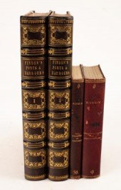 Beattie (William) & Bartlett
 (WH), Finden's Views: The Ports, Harbour, Watering-Places and Coast Scenery of Great Britain, London: George Virtue, 1844, 2 volumes, 4to, half leather with gilt tooling, marbled boards and endpapers, marbled page edges, multiple plates; together with Ruskin (John), The Harbours of England and The Seven Lamps of Architecture, London: George Allen, 1906, contemporary leather, AEG (4)/Provenance: From the Library of Paul Stickler, a Gloucestershire collector of books a
Beattie (William) & Bartlett
Beattie (William) & Bartlett (WH), Finden's Views: The Ports, Harbour, Watering-Places and Coast Scenery of Great Britain, London: George Virtue, 1844, 2 volumes, 4to, half leather with gilt tooling, marbled boards and endpapers, marbled page edges, multiple plates; together with Ruskin (John), The Harbours of England and The Seven Lamps of Architecture, London: George Allen, 1906, contemporary leather, AEG (4)/Provenance: From the Library of Paul Stickler, a Gloucestershire collector of books a -
 Wartime Charleston Group of Eight
 Scarce CDV Exterior Views Eight fantastically detailed outdoor views of Ft. Sumter and environs by noted local photographer H.C. Foster Charleston taken in April 1865 during the festivities surrounding the official flag raising ceremony at Fort Sumter. Five of the stark views reveal the crumbling casemates and makeshift interior of Fort Sumter after nearly four years of sustained bombardment. Another view shows the ruins of St. Finebar??Ts Church on Broad Street amidst the skeletal remains of the devastated city. Note the scaffolding put in place to commence repairs. Highlighting the vanquished Confederacy is a temporary artillery park in a shady vista showing captured Confederate ordinance parked wheel-to-wheel with rows of heavy shells marked by type and size. The most memorable carte depicts Fort Sumter??Ts cluttered parade ground and flag pole bedecked in patriotic bunting in preparation for the flag raising ceremony. A gallery of invited civilian dignitaries and casually milling soldiers assemble to view the spectacle in this amazingly candid photograph. A hundred tiny soldiers and a battery of cannons appear on upper parapet with warships anchored on the horizon. On April 14 1865 retired General Robert Anderson the ?Hero of Sumter ? symbolically hoisted the national colors over the remains of the post where the Civil War began. Descended in the Family of Mary Crovatt Hambidge Condition: CDV??Ts uniformly VG. with sharp edges and strong corners. Albumens are crystal clear with strong detail and contrast.
Wartime Charleston Group of Eight
Wartime Charleston Group of Eight Scarce CDV Exterior Views Eight fantastically detailed outdoor views of Ft. Sumter and environs by noted local photographer H.C. Foster Charleston taken in April 1865 during the festivities surrounding the official flag raising ceremony at Fort Sumter. Five of the stark views reveal the crumbling casemates and makeshift interior of Fort Sumter after nearly four years of sustained bombardment. Another view shows the ruins of St. Finebar??Ts Church on Broad Street amidst the skeletal remains of the devastated city. Note the scaffolding put in place to commence repairs. Highlighting the vanquished Confederacy is a temporary artillery park in a shady vista showing captured Confederate ordinance parked wheel-to-wheel with rows of heavy shells marked by type and size. The most memorable carte depicts Fort Sumter??Ts cluttered parade ground and flag pole bedecked in patriotic bunting in preparation for the flag raising ceremony. A gallery of invited civilian dignitaries and casually milling soldiers assemble to view the spectacle in this amazingly candid photograph. A hundred tiny soldiers and a battery of cannons appear on upper parapet with warships anchored on the horizon. On April 14 1865 retired General Robert Anderson the ?Hero of Sumter ? symbolically hoisted the national colors over the remains of the post where the Civil War began. Descended in the Family of Mary Crovatt Hambidge Condition: CDV??Ts uniformly VG. with sharp edges and strong corners. Albumens are crystal clear with strong detail and contrast. -
 Henry Mouzon's map of the
 Carolinas, "An Accurate Map of North and South Carolina with their Indian Frontiers, Shewing [sic] in a distinct manner all the Mountains, Rivers, Swamps, Marshes, Bays, Creeks, Harbours, Sandbanks and Soundings on the Coasts; with the Roads and Indian Paths; as well as the Boundary or Provincial Lines, The Several Townships and other divisions of the Land in Both the Provinces; the whole From Actual Surveys By Henry Mouzon and others", published by Sawyer and Bennett, London, 1775, showing the coastal areas of the Carolinas extending west to the Appalachian Mountains, "Harbour of Port Royal" and "Bar and Harbour of Charlestown" vignettes in lower corners, copper engraving on laid paper with some hand-colored outlines, two unjoined sections with matching watermarks, British, late 18th century, each consisting of four pages, each section approximately 21-3/4 x 51-1/2 in.; modern wood frames. Both loose in frame, creases (several center creases reinforced), folds, moisture stains, toning, scattered foxing, losses at margins including sections of border and plate marks, lower section with 6-1/2 x 1/2 in. repair to left side, possibly period ink stamp and later pencil inscriptions verso; frames with abrasions and separations.
Henry Mouzon's map of the
Henry Mouzon's map of the Carolinas, "An Accurate Map of North and South Carolina with their Indian Frontiers, Shewing [sic] in a distinct manner all the Mountains, Rivers, Swamps, Marshes, Bays, Creeks, Harbours, Sandbanks and Soundings on the Coasts; with the Roads and Indian Paths; as well as the Boundary or Provincial Lines, The Several Townships and other divisions of the Land in Both the Provinces; the whole From Actual Surveys By Henry Mouzon and others", published by Sawyer and Bennett, London, 1775, showing the coastal areas of the Carolinas extending west to the Appalachian Mountains, "Harbour of Port Royal" and "Bar and Harbour of Charlestown" vignettes in lower corners, copper engraving on laid paper with some hand-colored outlines, two unjoined sections with matching watermarks, British, late 18th century, each consisting of four pages, each section approximately 21-3/4 x 51-1/2 in.; modern wood frames. Both loose in frame, creases (several center creases reinforced), folds, moisture stains, toning, scattered foxing, losses at margins including sections of border and plate marks, lower section with 6-1/2 x 1/2 in. repair to left side, possibly period ink stamp and later pencil inscriptions verso; frames with abrasions and separations. -
 ARCHIBALD W. Stuart (American
 20th Century): Coastal Surf Crashing ''Fortune's Rock'' Watercolor sight size 9 1/2'' x 13 1/2'' signed framed 20'' x 23 1/2''.
ARCHIBALD W. Stuart (American
ARCHIBALD W. Stuart (American 20th Century): Coastal Surf Crashing ''Fortune's Rock'' Watercolor sight size 9 1/2'' x 13 1/2'' signed framed 20'' x 23 1/2''.
...many more examples with full details are available to our members - Learn more
Easy & Visual methods to Identify & Appraise Antiques & Collectibles
EASY. FAST. ACCURATE.
Research at its best
We are here to help!
Our research tools include:

Thousands of makers marks for PORCELAIN, POTTERY CHINAWARE, FIGURINES, VASES
see details...

Thousands of marks & hallmarks for SILVER & JEWELRY, PEWTER, PRECIOUS METALS, SILVERPLATE
see details...
