Pricing Guides & Dictionary of Makers Marks for Antiques & Collectibles
A few examples of appraisal values for
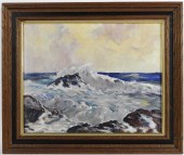
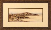
BEAUTY OF THE ATLANTIC
Search our price guide for your own treasures
-
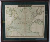
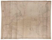
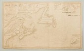
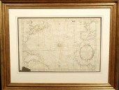 French map of the Atlantic Ocean by
 Bellin c.1760 framed and matted. As found. 13"x20"
French map of the Atlantic Ocean by
French map of the Atlantic Ocean by Bellin c.1760 framed and matted. As found. 13"x20" -
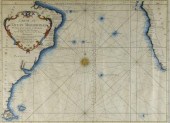 SEA FARING MAP, ATLANTIC OCEAN,
 1746A map (folds), "Carte De L’Océan Méridional", by M. Bellin, Marine Engineer. A very interesting sea faring map delineating the major navigational routes between southern Africa and South America. Hand coloured with a decorative central compass rose and dated 1746. Framed. 13 3/8" x 17 3/4".
SEA FARING MAP, ATLANTIC OCEAN,
SEA FARING MAP, ATLANTIC OCEAN, 1746A map (folds), "Carte De L’Océan Méridional", by M. Bellin, Marine Engineer. A very interesting sea faring map delineating the major navigational routes between southern Africa and South America. Hand coloured with a decorative central compass rose and dated 1746. Framed. 13 3/8" x 17 3/4". -
 Constance B Nash (British
 1921-2015)/Atlantic Storm in the Canary Isles/oil on board, 63cm x 76cm/and three others by the same hand
Constance B Nash (British
Constance B Nash (British 1921-2015)/Atlantic Storm in the Canary Isles/oil on board, 63cm x 76cm/and three others by the same hand -
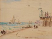
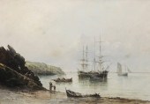
 A Pair of Color Lithographs Currier
 and Ives comprising Beauty of the Atlantic and The Bride of the West. Height of each 13 1/2 x width 10 1/2 inches.
A Pair of Color Lithographs Currier
A Pair of Color Lithographs Currier and Ives comprising Beauty of the Atlantic and The Bride of the West. Height of each 13 1/2 x width 10 1/2 inches. -
 William Brandford Green (1871-1945,
 NY/CT), oil on canvas titled "Atlantic Coast", dated 1932. 17" x 22" ss / 21.5" x 27" oa Condition: Cracking to paint.
William Brandford Green (1871-1945,
William Brandford Green (1871-1945, NY/CT), oil on canvas titled "Atlantic Coast", dated 1932. 17" x 22" ss / 21.5" x 27" oa Condition: Cracking to paint. -
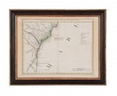
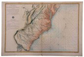
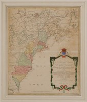 Map of Colonial America Carte
 Nouvelle de L'Amerique Angloise… by Matthieu Albert Lotter, Augsburg, circa 1776, from Lotter's Atlas Geographique, showing the Atlantic seaboard from Canada to Florida with the 13 original colonies filled in and outlined in hand color, on wove paper, 23-3/4 x 19-1/4 in. (sight), modern wood frame,
Map of Colonial America Carte
Map of Colonial America Carte Nouvelle de L'Amerique Angloise… by Matthieu Albert Lotter, Augsburg, circa 1776, from Lotter's Atlas Geographique, showing the Atlantic seaboard from Canada to Florida with the 13 original colonies filled in and outlined in hand color, on wove paper, 23-3/4 x 19-1/4 in. (sight), modern wood frame, -
 ARTHUR BEAUMONT IMPRESSIONIST
 HARBOR O/B PAINTING New York,1877-1956Coastal seascape depicting a fishing harbor with two boats and several figures in the foreground with a nicely mottled reflection. The artist began a landscape on the verso.
ARTHUR BEAUMONT IMPRESSIONIST
ARTHUR BEAUMONT IMPRESSIONIST HARBOR O/B PAINTING New York,1877-1956Coastal seascape depicting a fishing harbor with two boats and several figures in the foreground with a nicely mottled reflection. The artist began a landscape on the verso. -
 19TH CENTURY COLORED CHART OF THE
 NORTH ATLANTICOCEAN, WITH TRACKS OF SHIPPING TO THE WEST INDIES AND NORTH AMERICA, AS WELL AS BORDERING LAND MASSES. SHOWS MINOR STAINING AND FOXING, FOLD IN CENTER, AND MINOR LOSS TO THE BOTTOM BORDER. ENGRAVED BY JOHN MOFFAT, EDINBURGH. SIGHT SIZE 21 1/2" X 25 1/2" , OVERALL 27 1/4" X 31".
19TH CENTURY COLORED CHART OF THE
19TH CENTURY COLORED CHART OF THE NORTH ATLANTICOCEAN, WITH TRACKS OF SHIPPING TO THE WEST INDIES AND NORTH AMERICA, AS WELL AS BORDERING LAND MASSES. SHOWS MINOR STAINING AND FOXING, FOLD IN CENTER, AND MINOR LOSS TO THE BOTTOM BORDER. ENGRAVED BY JOHN MOFFAT, EDINBURGH. SIGHT SIZE 21 1/2" X 25 1/2" , OVERALL 27 1/4" X 31". -
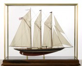
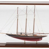 A Cased Scale Model of a Three-Mast
 Ship titled Atlantic, by Seacraft Classics. Height of case 24 x length 33 x depth 10 inches. Property from Mrs. Louis Fodor, Cleveland, Ohio
A Cased Scale Model of a Three-Mast
A Cased Scale Model of a Three-Mast Ship titled Atlantic, by Seacraft Classics. Height of case 24 x length 33 x depth 10 inches. Property from Mrs. Louis Fodor, Cleveland, Ohio -
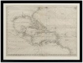
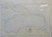 NORTH ATLANTIC OCEAN, CARIBBEAN
 SEA, REPRODUCTION COLOR PRINT MAP FRAME: 31 1/2 X 43 1/2 IN. (80.01 X 110.49 CM.)North Atlantic Ocean, Caribbean Sea, Reproduction Color Print Map, Dimensions: Frame: 31 1/2 x 43 1/2 in. (80.01 x 110.49 cm.)
NORTH ATLANTIC OCEAN, CARIBBEAN
NORTH ATLANTIC OCEAN, CARIBBEAN SEA, REPRODUCTION COLOR PRINT MAP FRAME: 31 1/2 X 43 1/2 IN. (80.01 X 110.49 CM.)North Atlantic Ocean, Caribbean Sea, Reproduction Color Print Map, Dimensions: Frame: 31 1/2 x 43 1/2 in. (80.01 x 110.49 cm.) -
 BLUEBACK CHART OF THE NORTH
 ATLANTIC OCEAN PUBLISHED 1844 APPROX. 38" X 48.5".BLUEBACK CHART OF THE NORTH ATLANTIC OCEAN, Published 1844, Published by E. & G.W. Blunt, New York. Marked with numerous navigational notations in pen and pencil. Dimensions: Approx. 38" x 48.5".
BLUEBACK CHART OF THE NORTH
BLUEBACK CHART OF THE NORTH ATLANTIC OCEAN PUBLISHED 1844 APPROX. 38" X 48.5".BLUEBACK CHART OF THE NORTH ATLANTIC OCEAN, Published 1844, Published by E. & G.W. Blunt, New York. Marked with numerous navigational notations in pen and pencil. Dimensions: Approx. 38" x 48.5". -
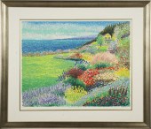
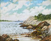 NEW ENGLAND COASTAL LANDSCAPE
 PAINTING America,20th CenturyImpressionistic scene of gentle waves rippling against a sandy alcove surrounded by rock formations and trees.
NEW ENGLAND COASTAL LANDSCAPE
NEW ENGLAND COASTAL LANDSCAPE PAINTING America,20th CenturyImpressionistic scene of gentle waves rippling against a sandy alcove surrounded by rock formations and trees. -
 LATE. 18TH C. PARTIAL MAP OF THE
 ATLANTIC COAST Antonio Zatta (Italian 1757-1797), "Parte Orientale della Florida, della Georgia, e Carolina Meridionale" late 18th century, etching on paper depicting the Atlantic coast during the American Civil War, produced for an atlas, framed. Approximate dimensions: image h. 12.375", w. 16.625"; frame h. 18", w. 23", d. 1.25".
LATE. 18TH C. PARTIAL MAP OF THE
LATE. 18TH C. PARTIAL MAP OF THE ATLANTIC COAST Antonio Zatta (Italian 1757-1797), "Parte Orientale della Florida, della Georgia, e Carolina Meridionale" late 18th century, etching on paper depicting the Atlantic coast during the American Civil War, produced for an atlas, framed. Approximate dimensions: image h. 12.375", w. 16.625"; frame h. 18", w. 23", d. 1.25". -
 18th century map of the Americas,
 Plate 3 of "Ocean Atlantique et Mers Adjacentes en Quatre Feuilles…" by Robert Sayer, showing southeastern North America, the Gulf of Mexico, the Caribbean Islands, and northern South America, published in Pilote Americain by George Louis Le Rouge, France, 1778, copper engraving on laid paper with watermarks, page 21 x 28-1/2 in.; modern wood frame. Archival tape, earlier paper hinges still attached, toning, foxing, fading, soiling, stains, pest damage, reinforced center crease, tears and losses in margins, numerous fills and repaired tears, "56" in ink verso (probably period); frame with abrasions. Deaccessioned from MESDA and Old Salem to benefit the Acquisition Fund.
18th century map of the Americas,
18th century map of the Americas, Plate 3 of "Ocean Atlantique et Mers Adjacentes en Quatre Feuilles…" by Robert Sayer, showing southeastern North America, the Gulf of Mexico, the Caribbean Islands, and northern South America, published in Pilote Americain by George Louis Le Rouge, France, 1778, copper engraving on laid paper with watermarks, page 21 x 28-1/2 in.; modern wood frame. Archival tape, earlier paper hinges still attached, toning, foxing, fading, soiling, stains, pest damage, reinforced center crease, tears and losses in margins, numerous fills and repaired tears, "56" in ink verso (probably period); frame with abrasions. Deaccessioned from MESDA and Old Salem to benefit the Acquisition Fund. -
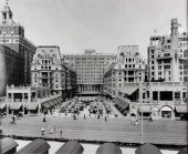 ATLANTIC CITY BOARDWALK Black and
 white photograph: 34 x 43 in. Framed
ATLANTIC CITY BOARDWALK Black and
ATLANTIC CITY BOARDWALK Black and white photograph: 34 x 43 in. Framed -
 BOOK, ATLANTIC COAST; PILOT
 BOSTON TO NEW YORK,QUARTO, SECOND EDITION, WASHINGTON 1880, LEATHER BINDING WITH MARBLEIZED BOARDS, 621 PAGES. APPROXIMATELY 39 PULLOUT MAPS TO INCLUDE MINOT LIGHT, BOSTON BAY & HARBOR, PROVINCETOWN, ENTRANCE TO NANTUCKET SOUND, GULF OF MAINE, BUZZARDS BAY, LONG ISLAND SOUND, ENTRANCE TO NEW YORK BAY AND OTHERS. ALL MAPS APPEAR TO BE IN GOOD CONDITION AND PRESENT. THE TEXT SHOWS LIGHT FOXING, SPINE AND BOARDS ARE SCUFFED AND WORN.
BOOK, ATLANTIC COAST; PILOT
BOOK, ATLANTIC COAST; PILOT BOSTON TO NEW YORK,QUARTO, SECOND EDITION, WASHINGTON 1880, LEATHER BINDING WITH MARBLEIZED BOARDS, 621 PAGES. APPROXIMATELY 39 PULLOUT MAPS TO INCLUDE MINOT LIGHT, BOSTON BAY & HARBOR, PROVINCETOWN, ENTRANCE TO NANTUCKET SOUND, GULF OF MAINE, BUZZARDS BAY, LONG ISLAND SOUND, ENTRANCE TO NEW YORK BAY AND OTHERS. ALL MAPS APPEAR TO BE IN GOOD CONDITION AND PRESENT. THE TEXT SHOWS LIGHT FOXING, SPINE AND BOARDS ARE SCUFFED AND WORN. -
 HELEN AUBOURG CAPE ANN COASTAL
 SEASCAPE PAINTING Massachusetts,20th CenturyImpressionist work depicting turbulent white capped waves crashing against rockery.
HELEN AUBOURG CAPE ANN COASTAL
HELEN AUBOURG CAPE ANN COASTAL SEASCAPE PAINTING Massachusetts,20th CenturyImpressionist work depicting turbulent white capped waves crashing against rockery. -
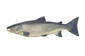 ATLANTIC SALMONJohn Tully
 (1862-1931) Fochabers, Scotland c. 1895 44 in. long Carved by John and painted by his wife, Dhuie Tully (1862-1950). John apprenticed under John Bucknell Russell (1819-1893), who pioneered fish model making in the 1870s. Isabella “Dhuie” Tully was Russell’s daughter. This forty-four-inch-long salmon carving has intricate detail and exceptional paint and reflects the artist’s best work. Literature: very good
ATLANTIC SALMONJohn Tully
ATLANTIC SALMONJohn Tully (1862-1931) Fochabers, Scotland c. 1895 44 in. long Carved by John and painted by his wife, Dhuie Tully (1862-1950). John apprenticed under John Bucknell Russell (1819-1893), who pioneered fish model making in the 1870s. Isabella “Dhuie” Tully was Russell’s daughter. This forty-four-inch-long salmon carving has intricate detail and exceptional paint and reflects the artist’s best work. Literature: very good -
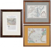 THREE FRAMED MAPS, ATLANTIC,
 CHESAPEAKE, AND THE AMERIC...engravings on laid paper with hand color, comprising: Jacques Nicolas Bellin, Carte De La Baye Chesapeack et pays Voisins... , Paris, circa 1757, sight 7-1/2 x 11-1/4 in.; Thomas Bowen, A New & Accurate Chart of the Western or Atlantic Ocean Drawn from Surveys and most approved Maps & Charts , London, 1788, sight 8 x 10 in.; Descrittione dell'America, o dell'India Occidentale. America , 1598, sight 11-1/4 x 7-3/4 in.; wood frames, 19-7/8 x 16-1/4 in. Condition: scattered light staining, toning, creasing, not examined out of frames; frames with light wear and abrasions
THREE FRAMED MAPS, ATLANTIC,
THREE FRAMED MAPS, ATLANTIC, CHESAPEAKE, AND THE AMERIC...engravings on laid paper with hand color, comprising: Jacques Nicolas Bellin, Carte De La Baye Chesapeack et pays Voisins... , Paris, circa 1757, sight 7-1/2 x 11-1/4 in.; Thomas Bowen, A New & Accurate Chart of the Western or Atlantic Ocean Drawn from Surveys and most approved Maps & Charts , London, 1788, sight 8 x 10 in.; Descrittione dell'America, o dell'India Occidentale. America , 1598, sight 11-1/4 x 7-3/4 in.; wood frames, 19-7/8 x 16-1/4 in. Condition: scattered light staining, toning, creasing, not examined out of frames; frames with light wear and abrasions -
 GUY BEGIN (1944- ): "ATLANTIC
 COLONY PERFUME"serigraph in colors; numbered 91/175 lower left; 21 x 26 inches; 31 3/4 x 36 1/2 inches frame Condition:
GUY BEGIN (1944- ): "ATLANTIC
GUY BEGIN (1944- ): "ATLANTIC COLONY PERFUME"serigraph in colors; numbered 91/175 lower left; 21 x 26 inches; 31 3/4 x 36 1/2 inches frame Condition: -
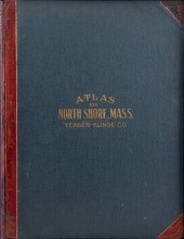 "ATLAS OF THE NORTH SHORE BEVERLY
 TO MAGNOLIA ESSEX CO. MASS.""ATLAS OF THE NORTH SHORE BEVERLY TO MAGNOLIA ESSEX CO. MASS.", Compiled and published by Yeager-Klinge Co. Engineers & Publishers 1919. Housed in a contemporary cloth-covered box with marbled interior. All 19 plates included. Provenance: Property of a direct descendant of Thomas Jefferson, the contents of the Brick House at Coolidge Point, Manchester by the Sea, Massachusetts.
"ATLAS OF THE NORTH SHORE BEVERLY
"ATLAS OF THE NORTH SHORE BEVERLY TO MAGNOLIA ESSEX CO. MASS.""ATLAS OF THE NORTH SHORE BEVERLY TO MAGNOLIA ESSEX CO. MASS.", Compiled and published by Yeager-Klinge Co. Engineers & Publishers 1919. Housed in a contemporary cloth-covered box with marbled interior. All 19 plates included. Provenance: Property of a direct descendant of Thomas Jefferson, the contents of the Brick House at Coolidge Point, Manchester by the Sea, Massachusetts. -
 NAUTICAL CHART: N. AMERICA INC.
 BOSTON, NOVA SCOTIANautical Map: A Chart of the Course of North America, from the Strait of Belle Isle to Boston, Banks and Island of Newfoundland, The Gulf and River of St. Lawrence, Nova Scotia, Bay of Fundie &c, Constructed and Drawn from the Latest Surveys by J.S. Hobbs, FRGS, Hydrographer, 1861. Printed on bottom margin: "A New Edition London 1859 by Charles Wilson at the Navigation Warehouse and Naval Academy." Shown are Boston Harbor, Halifax Harbor, Isle St. Pierre, St. John's, Island of St. Paul, Port St. Andrew, and more. Contains navigational advisory notes on topics such as water temperature, winds, and landmarks. Original blueback paper and canvas edging. A & H Creighton Navigational suppliers label en verso. 40" H x 66 1/4" W. (Higher-resolution photos are available at www.caseantiques.com) Condition: Edge staining, some small paper losses at lower edge, scattered fingerprint smudges and light foxing/staining scattered in the area near left third, scattered creasing, a couple of 1-2" tears at edges and corners.
NAUTICAL CHART: N. AMERICA INC.
NAUTICAL CHART: N. AMERICA INC. BOSTON, NOVA SCOTIANautical Map: A Chart of the Course of North America, from the Strait of Belle Isle to Boston, Banks and Island of Newfoundland, The Gulf and River of St. Lawrence, Nova Scotia, Bay of Fundie &c, Constructed and Drawn from the Latest Surveys by J.S. Hobbs, FRGS, Hydrographer, 1861. Printed on bottom margin: "A New Edition London 1859 by Charles Wilson at the Navigation Warehouse and Naval Academy." Shown are Boston Harbor, Halifax Harbor, Isle St. Pierre, St. John's, Island of St. Paul, Port St. Andrew, and more. Contains navigational advisory notes on topics such as water temperature, winds, and landmarks. Original blueback paper and canvas edging. A & H Creighton Navigational suppliers label en verso. 40" H x 66 1/4" W. (Higher-resolution photos are available at www.caseantiques.com) Condition: Edge staining, some small paper losses at lower edge, scattered fingerprint smudges and light foxing/staining scattered in the area near left third, scattered creasing, a couple of 1-2" tears at edges and corners. -
 CASED MODEL OF THE SCHOONER YACHT
 ATLANTICFull suit of sails and complete rigging. Four lifeboats and launches hanging from davits. Planked hull. Case height 27. Length 34''. Width 11''.''
CASED MODEL OF THE SCHOONER YACHT
CASED MODEL OF THE SCHOONER YACHT ATLANTICFull suit of sails and complete rigging. Four lifeboats and launches hanging from davits. Planked hull. Case height 27. Length 34''. Width 11''.'' -
 ROBERT ARTHUR COASTAL MAINE WC
 PAINTING Massachusetts,1850-1914Impressionist coastal depiction of ocean waves crashing against large boulders.
ROBERT ARTHUR COASTAL MAINE WC
ROBERT ARTHUR COASTAL MAINE WC PAINTING Massachusetts,1850-1914Impressionist coastal depiction of ocean waves crashing against large boulders. -
 REYNOLDS BEAL, (AMERICAN,
 1866-1951), ATLANTIC CITY SHORELINE, WATERCOLOR AND PENCIL ON PAPER, SHEET: 6 1/4 X 9 IN., FRAME: 17 1/2 X 19 IN.REYNOLDS BEAL, (American, 1866-1951) Atlantic City Shoreline, watercolor and pencil on paper watercolor and pencil on paper Dimensions: sheet: 6 1/4 x 9 in., frame: 17 1/2 x 19 in. Provenance: The artist's family; The Collection of Robert C. Campbell, Boston; with Vose Galleries, Boston; The Estate of a Massachusetts Gentleman. Condition: Please note: All property is sold "AS IS" and any statement, whether oral or written, is given as a courtesy and shall not be deemed as a guarantee, warranty, or representation of the authenticity of authorship, physical condition, size, quality, rarity, importance, provenance, exhibitions, literature or historical relevance of the property or otherwise. The absence of a condition report does not imply the item is in perfect condition.
REYNOLDS BEAL, (AMERICAN,
REYNOLDS BEAL, (AMERICAN, 1866-1951), ATLANTIC CITY SHORELINE, WATERCOLOR AND PENCIL ON PAPER, SHEET: 6 1/4 X 9 IN., FRAME: 17 1/2 X 19 IN.REYNOLDS BEAL, (American, 1866-1951) Atlantic City Shoreline, watercolor and pencil on paper watercolor and pencil on paper Dimensions: sheet: 6 1/4 x 9 in., frame: 17 1/2 x 19 in. Provenance: The artist's family; The Collection of Robert C. Campbell, Boston; with Vose Galleries, Boston; The Estate of a Massachusetts Gentleman. Condition: Please note: All property is sold "AS IS" and any statement, whether oral or written, is given as a courtesy and shall not be deemed as a guarantee, warranty, or representation of the authenticity of authorship, physical condition, size, quality, rarity, importance, provenance, exhibitions, literature or historical relevance of the property or otherwise. The absence of a condition report does not imply the item is in perfect condition. -
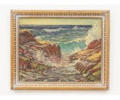
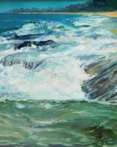
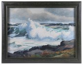 ALFRED RUSSEL FULLER (ME/CA,
 1899-1980) "Atlantic Breake (sic)", oil on panel, signed lower right, titled and signed on affixed label verso, depicting a large wave crashing near a rocky shore, in a painted wooden frame, OS: 21 3/4" x 27 3/4", SS: 17 1/2" x 23 1/2". Good condition.
ALFRED RUSSEL FULLER (ME/CA,
ALFRED RUSSEL FULLER (ME/CA, 1899-1980) "Atlantic Breake (sic)", oil on panel, signed lower right, titled and signed on affixed label verso, depicting a large wave crashing near a rocky shore, in a painted wooden frame, OS: 21 3/4" x 27 3/4", SS: 17 1/2" x 23 1/2". Good condition. -
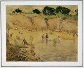 ROBERT NISBET COASTAL BATHERS
 SEASCAPE PAINTING Connecticut, Rhode Island,1879-1961Depicting a small communal beach in an out cove with several people enjoying a beautiful summer's day.
ROBERT NISBET COASTAL BATHERS
ROBERT NISBET COASTAL BATHERS SEASCAPE PAINTING Connecticut, Rhode Island,1879-1961Depicting a small communal beach in an out cove with several people enjoying a beautiful summer's day. -
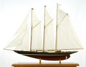 MODEL OF THE SCHOONER YACHT
 ATLANTICWith planked mahogany deck. Height 46. Length 59''. Width 12''.''
MODEL OF THE SCHOONER YACHT
MODEL OF THE SCHOONER YACHT ATLANTICWith planked mahogany deck. Height 46. Length 59''. Width 12''.'' -
 Alfred Thomas Bricher (American/New
 Hampshire, 1837-1908) "View of a Rocky Coastline with Sailboats in the Distance", watercolor, sight 8" x 14", signed lower left "A. Bricher". Glazed, handsomely matted and framed.
Alfred Thomas Bricher (American/New
Alfred Thomas Bricher (American/New Hampshire, 1837-1908) "View of a Rocky Coastline with Sailboats in the Distance", watercolor, sight 8" x 14", signed lower left "A. Bricher". Glazed, handsomely matted and framed. -
 ROBERT JONES OIL ON CANVAS
 "ATLANTIC SHORE II"Robert Jones (b. Cornwall 1947) Oil on Canvas "Atlantic Shore II" , signed lower right "RJ" 2006, signed, titled and dated in pencil on reverse of stretcher Overall 40 in. x 48 in. Jones studied fine art at the Falmouth School of Art; prior to becoming a full time artist, Jones was a fisherman in the inshore waters of his native Cornwall; it was during this time that his love of the sea developed and now as a mature painter, it is the themes to which he is drawn Condition: Items may have wear and tear, imperfections or the effects of aging. Please contact the gallery for further details prior to bidding. Any condition statement given as a courtesy should not be treated as fact.
ROBERT JONES OIL ON CANVAS
ROBERT JONES OIL ON CANVAS "ATLANTIC SHORE II"Robert Jones (b. Cornwall 1947) Oil on Canvas "Atlantic Shore II" , signed lower right "RJ" 2006, signed, titled and dated in pencil on reverse of stretcher Overall 40 in. x 48 in. Jones studied fine art at the Falmouth School of Art; prior to becoming a full time artist, Jones was a fisherman in the inshore waters of his native Cornwall; it was during this time that his love of the sea developed and now as a mature painter, it is the themes to which he is drawn Condition: Items may have wear and tear, imperfections or the effects of aging. Please contact the gallery for further details prior to bidding. Any condition statement given as a courtesy should not be treated as fact. -
 HELEN AUBOURG CAPE ANN GLOUCESTER
 HARBOR PAINTING Massachusetts,20th CenturyImpressionist work depicting a sailing vessel docked in a small cove with short grass and rockery on shore in the foreground.
HELEN AUBOURG CAPE ANN GLOUCESTER
HELEN AUBOURG CAPE ANN GLOUCESTER HARBOR PAINTING Massachusetts,20th CenturyImpressionist work depicting a sailing vessel docked in a small cove with short grass and rockery on shore in the foreground. -
 Bernard C. Scott (British, 20th
 Century) Atlantic Crossing, 1990 gouache signed Bernard C Scott and dated (lower right) 19 x 25 inches The Laumeister Collection from The Bennington Center for the Arts, Bennington, Vermont
Bernard C. Scott (British, 20th
Bernard C. Scott (British, 20th Century) Atlantic Crossing, 1990 gouache signed Bernard C Scott and dated (lower right) 19 x 25 inches The Laumeister Collection from The Bennington Center for the Arts, Bennington, Vermont -
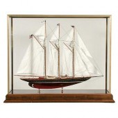 CASED MODEL OF THE SCHOONER YACHT
 "ATLANTIC"Cased Ship Model of The Atlantic. Highly detailed model of the Schooner Yacht Atlantic. Details include winch, ventilators, companionways, masts, booms, rigging and full suite of stitched linen sails, anchor and davit, engine room lights, funnel, deck lights, cleats etc. The hull is painted black above the waterline and red below. The model is mounted into a brass and glass display case with marquetry inlay. 27 1/2" x 35" x 11". 20th c. Very good condition.
CASED MODEL OF THE SCHOONER YACHT
CASED MODEL OF THE SCHOONER YACHT "ATLANTIC"Cased Ship Model of The Atlantic. Highly detailed model of the Schooner Yacht Atlantic. Details include winch, ventilators, companionways, masts, booms, rigging and full suite of stitched linen sails, anchor and davit, engine room lights, funnel, deck lights, cleats etc. The hull is painted black above the waterline and red below. The model is mounted into a brass and glass display case with marquetry inlay. 27 1/2" x 35" x 11". 20th c. Very good condition. -
 SARTINE - MAP OF THE ATLANTIC
 COAST, 1778 MAPAntoine Sartine (1729-1801), Carte Reduite des Cotes Orientales De L'Amerique Septentrionale Contentant Partie du Nouveau Jersey, la Pen-sylvanie, le Mary-land, la Virginie, la Caroline Septentrionale, la Caroline Meridionale et la Georgie... , Paris, from the French government-issued Neptune Americo-Septentrional (also known as American Neptune), in two sheets, engraving on laid paper with hand colored highlights, plate 23-1/2 x 35 in., sheet 25-1/2 x 37-1/4 in., unframed Provenance: Humber Family, North Carolina Condition: joined at center, some areas of scattered light staining and foxing throughout, wear and small tears to edges, some handling creases, reinforcement at top left corner verso
SARTINE - MAP OF THE ATLANTIC
SARTINE - MAP OF THE ATLANTIC COAST, 1778 MAPAntoine Sartine (1729-1801), Carte Reduite des Cotes Orientales De L'Amerique Septentrionale Contentant Partie du Nouveau Jersey, la Pen-sylvanie, le Mary-land, la Virginie, la Caroline Septentrionale, la Caroline Meridionale et la Georgie... , Paris, from the French government-issued Neptune Americo-Septentrional (also known as American Neptune), in two sheets, engraving on laid paper with hand colored highlights, plate 23-1/2 x 35 in., sheet 25-1/2 x 37-1/4 in., unframed Provenance: Humber Family, North Carolina Condition: joined at center, some areas of scattered light staining and foxing throughout, wear and small tears to edges, some handling creases, reinforcement at top left corner verso -
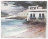
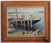
 P.E. DeLangle (French, 20th
 century) Coastal Landscape, moored fishing v
P.E. DeLangle (French, 20th
P.E. DeLangle (French, 20th century) Coastal Landscape, moored fishing v -
 DOROTHY TARR NEW ENGLAND O/C
 SEASCAPE PAINTING United States,20th CenturyDepicts crashing waves upon a rocky New England seashore.
DOROTHY TARR NEW ENGLAND O/C
DOROTHY TARR NEW ENGLAND O/C SEASCAPE PAINTING United States,20th CenturyDepicts crashing waves upon a rocky New England seashore.
...many more examples with full details are available to our members - Learn more
Easy & Visual methods to Identify & Appraise Antiques & Collectibles
EASY. FAST. ACCURATE.
Research at its best
We are here to help!
Our research tools include:

Thousands of makers marks for PORCELAIN, POTTERY CHINAWARE, FIGURINES, VASES
see details...

Thousands of marks & hallmarks for SILVER & JEWELRY, PEWTER, PRECIOUS METALS, SILVERPLATE
see details...
