Pricing Guides & Dictionary of Makers Marks for Antiques & Collectibles
A few examples of appraisal values for
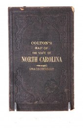
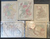
COLTON 12
Search our price guide for your own treasures
-
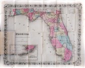 1856 MAP OF FLORIDA COLTON,
 HAND-COLOREDAntebellum, dated 1856 folding map of Florida published by J.H.Colton, hand-colored and in magnificent condition.
1856 MAP OF FLORIDA COLTON,
1856 MAP OF FLORIDA COLTON, HAND-COLOREDAntebellum, dated 1856 folding map of Florida published by J.H.Colton, hand-colored and in magnificent condition. -
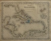 COLTON'S WEST INDIES, COLOR
 ENGRAVED MAP, FRAME: 18 3/4 X 21 1/2 IN. (47.63 X 54.61 CM.)Colton's West Indies, Color Engraved Map,, Dimensions: Frame: 18
COLTON'S WEST INDIES, COLOR
COLTON'S WEST INDIES, COLOR ENGRAVED MAP, FRAME: 18 3/4 X 21 1/2 IN. (47.63 X 54.61 CM.)Colton's West Indies, Color Engraved Map,, Dimensions: Frame: 18 -
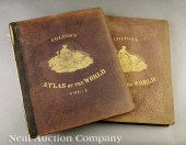 [American World Atlas] Colton's
 Atlas of the World Illustrating Physical and Political Geography J.H. Colton and Company No. 172 William New York 1856
[American World Atlas] Colton's
[American World Atlas] Colton's Atlas of the World Illustrating Physical and Political Geography J.H. Colton and Company No. 172 William New York 1856 -
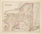
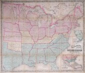 COLTON'S MAP OF THE UNITED STATES
 SHOWING THE PROPOSED RAILROAD ROUTES TO THE PACIFIC OCEAN, PUBLISHED BY J.H. COLTON, 1861 WIDTH (WHEN OPENED): 39 1/2
COLTON'S MAP OF THE UNITED STATES
COLTON'S MAP OF THE UNITED STATES SHOWING THE PROPOSED RAILROAD ROUTES TO THE PACIFIC OCEAN, PUBLISHED BY J.H. COLTON, 1861 WIDTH (WHEN OPENED): 39 1/2 -
 Travel maps of North and South
 Carolina consisting of: COLTON'S MAP OF THE STATE OF NORTH CAROLINA WITH PORTIONS OF ADJOINING STATES 1866. Late 19th century
Travel maps of North and South
Travel maps of North and South Carolina consisting of: COLTON'S MAP OF THE STATE OF NORTH CAROLINA WITH PORTIONS OF ADJOINING STATES 1866. Late 19th century -
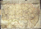 3 pieces. Fold Maps: Colton,
 G.W.G. & C.B., publisher. "Colton's New Township Map of Pennsylvania & The Southern Counties of New York." New York, 1871.
3 pieces. Fold Maps: Colton,
3 pieces. Fold Maps: Colton, G.W.G. & C.B., publisher. "Colton's New Township Map of Pennsylvania & The Southern Counties of New York." New York, 1871. -
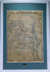 J. H. COLTON FOR WARREN HOLT
 VIRGINIA MARYLAND MAP California,1864J. H. Colton topographical map of Seat of War in Virginia, Maryland, & c. depicting a
J. H. COLTON FOR WARREN HOLT
J. H. COLTON FOR WARREN HOLT VIRGINIA MARYLAND MAP California,1864J. H. Colton topographical map of Seat of War in Virginia, Maryland, & c. depicting a -
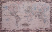 REPRODUCTION COLTON'S ILLUSTRATED
 AND EMBELLISHED MAP OF THE WORLD, PHOTOPRINT, FRAME: 32 1/2 X 47 1/4 IN. (82.6 X 120 CM.)Reproduction Colton's Illustrated
REPRODUCTION COLTON'S ILLUSTRATED
REPRODUCTION COLTON'S ILLUSTRATED AND EMBELLISHED MAP OF THE WORLD, PHOTOPRINT, FRAME: 32 1/2 X 47 1/4 IN. (82.6 X 120 CM.)Reproduction Colton's Illustrated -
 COLTON G[EORGE] WOOLWORTH
 Colton's General Atlas Containing One Hundred and Seventy Steel Plate Maps and Plans on One Hundred Imperial Folio Sheets. New
COLTON G[EORGE] WOOLWORTH
COLTON G[EORGE] WOOLWORTH Colton's General Atlas Containing One Hundred and Seventy Steel Plate Maps and Plans on One Hundred Imperial Folio Sheets. New -
 [ATLASES]. JOHNSON, A.J. and J.H.
 COLTON. Johnson's New Illustrated (Steel Plate) Family Atlas, with Descriptions, Geographical, Statistical, and Historical.
[ATLASES]. JOHNSON, A.J. and J.H.
[ATLASES]. JOHNSON, A.J. and J.H. COLTON. Johnson's New Illustrated (Steel Plate) Family Atlas, with Descriptions, Geographical, Statistical, and Historical. -
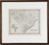 19th century maps of South Carolina
 SOUTH CAROLINA inset with PLAN OF CHARLESTON. New York: J.H. Colton & Co. 1855. Handcolored matted and framed; sight
19th century maps of South Carolina
19th century maps of South Carolina SOUTH CAROLINA inset with PLAN OF CHARLESTON. New York: J.H. Colton & Co. 1855. Handcolored matted and framed; sight -
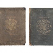
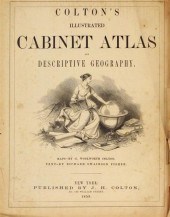 2 vols. American 19th-Century
 Atlases: Colton's Illustrated Cabinet Atlas and Descriptive Geography. New York: J.H. Colton, 1859. Folio, orig. morocco
2 vols. American 19th-Century
2 vols. American 19th-Century Atlases: Colton's Illustrated Cabinet Atlas and Descriptive Geography. New York: J.H. Colton, 1859. Folio, orig. morocco -
 J. H. COLTON & CO. AND OTHER
 PUBLISHERS, 15 COLOR ENGRAVED MAPS OF AMERICA, EUROPE AND OTHER AREAS, EACH UNFRAMED: LARGEST 13 1/2 X 17 1/2 IN. (34.29 X
J. H. COLTON & CO. AND OTHER
J. H. COLTON & CO. AND OTHER PUBLISHERS, 15 COLOR ENGRAVED MAPS OF AMERICA, EUROPE AND OTHER AREAS, EACH UNFRAMED: LARGEST 13 1/2 X 17 1/2 IN. (34.29 X
...many more examples with full details are available to our members - Learn more
Easy & Visual methods to Identify & Appraise Antiques & Collectibles
EASY. FAST. ACCURATE.
Research at its best
We are here to help!
Our research tools include:

Thousands of makers marks for PORCELAIN, POTTERY CHINAWARE, FIGURINES, VASES
see details...

Thousands of marks & hallmarks for SILVER & JEWELRY, PEWTER, PRECIOUS METALS, SILVERPLATE
see details...
