Pricing Guides & Dictionary of Makers Marks for Antiques & Collectibles
A few examples of appraisal values for
COLTON S MAPS
Search our price guide for your own treasures
-
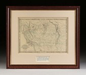
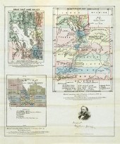
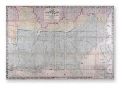 AN ANTIQUE CIVIL WAR MAP, "COLTON'S
 MAP OF THE SOUTHERN...AN ANTIQUE CIVIL WAR MAP, "Colton's Map of the Southern States," NEW YORK, CIRCA 1862, "...including Maryland, Delaware, Virginia, Kentucky, Tennessee, Missouri, North Carolina, South Carolina, Georgia, Alabama, Mississippi, Arkansas, Louisiana, and Texas. Showing also part of adjoining states & territories locating the forts and military stations of the United States and showing all the railroads, railroad stations, and other internal improvements. Published by J.H. Colton, 172 William Street, New York, 1862. 39" x 55 3/4" Condition: Simpson Galleries strongly encourages in-person inspection of items by the bidder. Statements by Simpson Galleries regarding the condition of objects are for guidance only and should not be relied upon as statements of fact and do not constitute a representation, warranty, or assumption of liability by Simpson Galleries. All lots offered are sold "AS IS."
AN ANTIQUE CIVIL WAR MAP, "COLTON'S
AN ANTIQUE CIVIL WAR MAP, "COLTON'S MAP OF THE SOUTHERN...AN ANTIQUE CIVIL WAR MAP, "Colton's Map of the Southern States," NEW YORK, CIRCA 1862, "...including Maryland, Delaware, Virginia, Kentucky, Tennessee, Missouri, North Carolina, South Carolina, Georgia, Alabama, Mississippi, Arkansas, Louisiana, and Texas. Showing also part of adjoining states & territories locating the forts and military stations of the United States and showing all the railroads, railroad stations, and other internal improvements. Published by J.H. Colton, 172 William Street, New York, 1862. 39" x 55 3/4" Condition: Simpson Galleries strongly encourages in-person inspection of items by the bidder. Statements by Simpson Galleries regarding the condition of objects are for guidance only and should not be relied upon as statements of fact and do not constitute a representation, warranty, or assumption of liability by Simpson Galleries. All lots offered are sold "AS IS." -
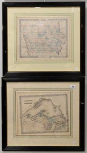
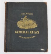
 COLTON G[EORGE] WOOLWORTH
 Colton's General Atlas Containing One Hundred and Seventy Steel Plate Maps and Plans on One Hundred Imperial Folio Sheets. New York: J.H. Colton; London: Trubner 1857. Atlas folio publisher's 1/2 morocco rebacked. Complete with 96 maps (including four double-page) and color frontispiece on 101 sheets as listed in index. Some light dampstaining; spine rebacked with tape and boards worn; hinges cracked; text block shifted; chipping to edge of the map of Sussex and proceeding two sheets of text; some maps toward the ends partially detached; some very light brown spots.
COLTON G[EORGE] WOOLWORTH
COLTON G[EORGE] WOOLWORTH Colton's General Atlas Containing One Hundred and Seventy Steel Plate Maps and Plans on One Hundred Imperial Folio Sheets. New York: J.H. Colton; London: Trubner 1857. Atlas folio publisher's 1/2 morocco rebacked. Complete with 96 maps (including four double-page) and color frontispiece on 101 sheets as listed in index. Some light dampstaining; spine rebacked with tape and boards worn; hinges cracked; text block shifted; chipping to edge of the map of Sussex and proceeding two sheets of text; some maps toward the ends partially detached; some very light brown spots. -
 Colton's 1849 Map of the U.S.
 Showing California Gold Fields Approx. 34 x 42 in. (sight) map dissected and mounted on linen. Hand-colored with inset map of the Atlantic Ocean with a number of ships traversing from European and American ports. Large decorative scene above title block. Numerous ships of many sail configurations in the Atlantic Caribbean Gulf of Mexico and Pacific Oceans. Ornamental border has 12 vignettes larger scenes in corners smaller along sides all surrounded by grapevines. Scenes include Willammette Falls Oregon; Astoria Oregon; Saratoga Lake NY; Valley of the Connecticut; Bunker Hill Monument; Washington Monument; Capital [sic - this is the misspelled version] Washington; Entrance of a Port; Mexicans Catching Wild Cattle; Cathedral City of Mexico; Pulaski Monument Savannah GA; Battle Monument Baltimore MD. The several Mexican vignettes are interesting as the Mexican War had just concluded.Colton's maps of 1849 were some of the earliest to indicate the California gold fields. This one has Gold Region just east of New Helvetia between the R de Plumes and Los Americanos [R.]. A slightly later edition put an insert map of the gold region - appropriately highlighted in yellow/gold - as in insert off the Pacific Coast with a vignette of Pyramid Lake. This is the edition most frequently encountered. In the edition offered here it appears that the information about gold had just been received and they put the text on the map quickly as it was going to press then reworked the map shortly thereafter. Not only is this a much scarcer edition the dissected maps were the most expensive when they were produced - a desirable and historically significant map. Condition: Minor toning particularly visible on the linen. Color somewhat faded. Overall very good; not removed from frame for examination.
Colton's 1849 Map of the U.S.
Colton's 1849 Map of the U.S. Showing California Gold Fields Approx. 34 x 42 in. (sight) map dissected and mounted on linen. Hand-colored with inset map of the Atlantic Ocean with a number of ships traversing from European and American ports. Large decorative scene above title block. Numerous ships of many sail configurations in the Atlantic Caribbean Gulf of Mexico and Pacific Oceans. Ornamental border has 12 vignettes larger scenes in corners smaller along sides all surrounded by grapevines. Scenes include Willammette Falls Oregon; Astoria Oregon; Saratoga Lake NY; Valley of the Connecticut; Bunker Hill Monument; Washington Monument; Capital [sic - this is the misspelled version] Washington; Entrance of a Port; Mexicans Catching Wild Cattle; Cathedral City of Mexico; Pulaski Monument Savannah GA; Battle Monument Baltimore MD. The several Mexican vignettes are interesting as the Mexican War had just concluded.Colton's maps of 1849 were some of the earliest to indicate the California gold fields. This one has Gold Region just east of New Helvetia between the R de Plumes and Los Americanos [R.]. A slightly later edition put an insert map of the gold region - appropriately highlighted in yellow/gold - as in insert off the Pacific Coast with a vignette of Pyramid Lake. This is the edition most frequently encountered. In the edition offered here it appears that the information about gold had just been received and they put the text on the map quickly as it was going to press then reworked the map shortly thereafter. Not only is this a much scarcer edition the dissected maps were the most expensive when they were produced - a desirable and historically significant map. Condition: Minor toning particularly visible on the linen. Color somewhat faded. Overall very good; not removed from frame for examination. -
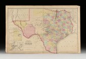 J.H. COLTON (1800-1893) A MAP, "NEW
 MAP OF THE STATE OF...J.H. COLTON (1800-1893) A MAP, "New Map of the State of Texas," NEW YORK, CIRCA 1855, hand-colored lithograph on paper, "Compiled from J. de Cordova's large Map," and, "Published by J.H. Colton & Co., No 172 William St., New York.," plates no. 37 and no. 38 joined, the map with three inset views lower left, "Plan of the northern part of Texas," "Plan of Galveston Bay from the U.S. Coast Survey," and, "Plan of Sabine Lake," sheet: 17" x 26 1/2". Condition: Some tears at ends, small surface stains, overall in good condition. Unframed. Simpson Galleries strongly encourages in-person inspection of items by the bidder. Statements by Simpson Galleries regarding the condition of objects are for guidance only and should not be relied upon as statements of fact and do not constitute a representation, warranty, or assumption of liability by Simpson Galleries. All lots offered are sold "AS IS."
J.H. COLTON (1800-1893) A MAP, "NEW
J.H. COLTON (1800-1893) A MAP, "NEW MAP OF THE STATE OF...J.H. COLTON (1800-1893) A MAP, "New Map of the State of Texas," NEW YORK, CIRCA 1855, hand-colored lithograph on paper, "Compiled from J. de Cordova's large Map," and, "Published by J.H. Colton & Co., No 172 William St., New York.," plates no. 37 and no. 38 joined, the map with three inset views lower left, "Plan of the northern part of Texas," "Plan of Galveston Bay from the U.S. Coast Survey," and, "Plan of Sabine Lake," sheet: 17" x 26 1/2". Condition: Some tears at ends, small surface stains, overall in good condition. Unframed. Simpson Galleries strongly encourages in-person inspection of items by the bidder. Statements by Simpson Galleries regarding the condition of objects are for guidance only and should not be relied upon as statements of fact and do not constitute a representation, warranty, or assumption of liability by Simpson Galleries. All lots offered are sold "AS IS." -
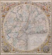
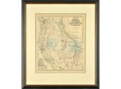 A framed antique map: Colton's
 7.247,550 of Nature, Oregon, Washington, California, Colorado, Nevada, Utah and New Mexico. Image 10.75" x 13" Overall framed 17" x 19.75" Condition: light foxing on map CT Transfer Fee $10
A framed antique map: Colton's
A framed antique map: Colton's 7.247,550 of Nature, Oregon, Washington, California, Colorado, Nevada, Utah and New Mexico. Image 10.75" x 13" Overall framed 17" x 19.75" Condition: light foxing on map CT Transfer Fee $10 -
 JOSEPH H. COLTON HAND COLORED
 ENGRAVED MAPS, COLTON'S A...Joseph H. Colton Hand Colored Engraved Maps, Colton's Atlas of the World including Georgia, St. Louis, Iowa, Michigan, Kentucky, Florida, Minnesota, and Missouri. Provenance: Originally from Credit Suisse's Americana Collection to present owner. Condition: All lots are sold "AS IS" The condition of lots can vary widely and are unlikely to be in a perfect condition. *No credit card payments will be accepted for silver, gold, or jewelry from buyers that have not purchased from our gallery in the past.
JOSEPH H. COLTON HAND COLORED
JOSEPH H. COLTON HAND COLORED ENGRAVED MAPS, COLTON'S A...Joseph H. Colton Hand Colored Engraved Maps, Colton's Atlas of the World including Georgia, St. Louis, Iowa, Michigan, Kentucky, Florida, Minnesota, and Missouri. Provenance: Originally from Credit Suisse's Americana Collection to present owner. Condition: All lots are sold "AS IS" The condition of lots can vary widely and are unlikely to be in a perfect condition. *No credit card payments will be accepted for silver, gold, or jewelry from buyers that have not purchased from our gallery in the past. -
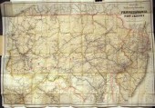 3 pieces. Fold Maps: Colton,
 G.W.G. & C.B., publisher. "Colton's New Township Map of Pennsylvania & The Southern Counties of New York." New York, 1871. Hand-colored lithographic map. 29 x 42 inches (735 x 1066 mm). A few tears in body of map, small paper loss, some creasing & minor dust soiling. Orig. cloth casing; rubbed, 1 cover detached. * Noll, E.P., publisher. "Noll's New Road Driving and Bicycle Map of Philadelphia and Surrounding Country." Philadelphia, 1890. Hand-colored lithographic map, 22 x 42 inches (559 x 1066 mm). Separations along folds, one surviving bd. of orig. casing. * Colton, G.W. & C.B., publisher. "Colton's New Township Railroad Map of Pennsylvania and New Jersey." New York, 1882. Lithographic map with outline color. 30 x 42 1/2 inches (762 x 1080 mm). Crayon pencil annotated railroad route added. Orig. cloth casing. Descriptions provided in both printed and on-line catalogue formats do not include condition reports. The absence of a condition statement does not imply that the lot is in perfect condition or completely free from wear and tear, imperfections or the effects of aging. Interested bidders are strongly encouraged to request a condition report on any lots upon which they intend to bid, prior to placing a bid. All transactions are governed by Freeman''s Conditions of Sale.
3 pieces. Fold Maps: Colton,
3 pieces. Fold Maps: Colton, G.W.G. & C.B., publisher. "Colton's New Township Map of Pennsylvania & The Southern Counties of New York." New York, 1871. Hand-colored lithographic map. 29 x 42 inches (735 x 1066 mm). A few tears in body of map, small paper loss, some creasing & minor dust soiling. Orig. cloth casing; rubbed, 1 cover detached. * Noll, E.P., publisher. "Noll's New Road Driving and Bicycle Map of Philadelphia and Surrounding Country." Philadelphia, 1890. Hand-colored lithographic map, 22 x 42 inches (559 x 1066 mm). Separations along folds, one surviving bd. of orig. casing. * Colton, G.W. & C.B., publisher. "Colton's New Township Railroad Map of Pennsylvania and New Jersey." New York, 1882. Lithographic map with outline color. 30 x 42 1/2 inches (762 x 1080 mm). Crayon pencil annotated railroad route added. Orig. cloth casing. Descriptions provided in both printed and on-line catalogue formats do not include condition reports. The absence of a condition statement does not imply that the lot is in perfect condition or completely free from wear and tear, imperfections or the effects of aging. Interested bidders are strongly encouraged to request a condition report on any lots upon which they intend to bid, prior to placing a bid. All transactions are governed by Freeman''s Conditions of Sale. -
 (MAPS) George W. Colton and R.
 S. Fisher; Colton's Atlas of the World (NY: Colton, 1856) 2 vols., large folio,
(MAPS) George W. Colton and R.
(MAPS) George W. Colton and R. S. Fisher; Colton's Atlas of the World (NY: Colton, 1856) 2 vols., large folio, -
 A GROUP OF FOUR BOOKS WITH MAPS
 OF TEXAS AND THE UNITED...A GROUP OF FOUR BOOKS WITH MAPS OF TEXAS AND THE UNITED STATES, comprising Colton's Map of Texas, G.W. and C.B. Colton, New York, 1873; 5 3/4'' x 3 3/4''; Colton's Map of Texas, G.W. and C.B Colton, New York, 1873; 5 3/4'' x 3 3/4''; Colton's Traveler's Map of the United States Showing the Counties, Railroads, &c., J.H. Colton, New York, 1864; 6 1/4'' x 4 1/4''; and A Description of Western Texas, published by Galveston, Harrisburg and San Antonio Railway Company, Galveston, 1876, with folded map in back; 7 1/2'' x 4 3/4''. (4) Condition: These books all show considerable wear inside and out. The covers are heavily worn with associated small losses. The Colton's Map of Texas books both have split and broken bindings. There are also pencil and pen markings inside the covers. All of the maps have splits and tears at edges and along fold lines and one has old tape stains. Simpson Galleries strongly encourages in-person inspection of items by the bidder. Statements by Simpson Galleries regarding the condition of objects are for guidance only and should not be relied upon as statements of fact and do not constitute a representation, warranty, or assumption of liability by Simpson Galleries. All lots offered are sold "AS IS.”
A GROUP OF FOUR BOOKS WITH MAPS
A GROUP OF FOUR BOOKS WITH MAPS OF TEXAS AND THE UNITED...A GROUP OF FOUR BOOKS WITH MAPS OF TEXAS AND THE UNITED STATES, comprising Colton's Map of Texas, G.W. and C.B. Colton, New York, 1873; 5 3/4'' x 3 3/4''; Colton's Map of Texas, G.W. and C.B Colton, New York, 1873; 5 3/4'' x 3 3/4''; Colton's Traveler's Map of the United States Showing the Counties, Railroads, &c., J.H. Colton, New York, 1864; 6 1/4'' x 4 1/4''; and A Description of Western Texas, published by Galveston, Harrisburg and San Antonio Railway Company, Galveston, 1876, with folded map in back; 7 1/2'' x 4 3/4''. (4) Condition: These books all show considerable wear inside and out. The covers are heavily worn with associated small losses. The Colton's Map of Texas books both have split and broken bindings. There are also pencil and pen markings inside the covers. All of the maps have splits and tears at edges and along fold lines and one has old tape stains. Simpson Galleries strongly encourages in-person inspection of items by the bidder. Statements by Simpson Galleries regarding the condition of objects are for guidance only and should not be relied upon as statements of fact and do not constitute a representation, warranty, or assumption of liability by Simpson Galleries. All lots offered are sold "AS IS.” -
 EIGHT JOSEPH H. COLTON HAND COLORED
 ENGRAVED MAPS FROM ...Eight Joseph H. Colton Hand Colored Engraved Maps from Colton's Atlas of the World, including Connecticut, Boston, Pittsburgh, Louisville, Michigan, Pennsylvania, Baltimore, Delaware; 13 1/2" x 17 1/2". Provenance: Originally from Credit Suisse's Americana Collection to present owner. Condition: All lots are sold "AS IS" The condition of lots can vary widely and are unlikely to be in a perfect condition. *No credit card payments will be accepted for silver, gold, or jewelry from buyers that have not purchased from our gallery in the past.
EIGHT JOSEPH H. COLTON HAND COLORED
EIGHT JOSEPH H. COLTON HAND COLORED ENGRAVED MAPS FROM ...Eight Joseph H. Colton Hand Colored Engraved Maps from Colton's Atlas of the World, including Connecticut, Boston, Pittsburgh, Louisville, Michigan, Pennsylvania, Baltimore, Delaware; 13 1/2" x 17 1/2". Provenance: Originally from Credit Suisse's Americana Collection to present owner. Condition: All lots are sold "AS IS" The condition of lots can vary widely and are unlikely to be in a perfect condition. *No credit card payments will be accepted for silver, gold, or jewelry from buyers that have not purchased from our gallery in the past. -
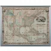
 COLTON'S MAP OF THE UNITED STATES
 SHOWING THE PROPOSED RAILROAD ROUTES TO THE PACIFIC OCEAN, PUBLISHED BY J.H. COLTON, 1861 WIDTH (WHEN OPENED): 39 1/2 IN. (100.33 CM.)COLTON'S MAP OF THE UNITED STATES SHOWING THE PROPOSED RAILROAD ROUTES TO THE PACIFIC OCEAN, PUBLISHED BY J.H. COLTON, 1861, [Maps and Atlases] hand-colored map laid down on linen, with original green cloth slipcase with gilt title 'United States of America', the colors denote: Confederacy green, North red, border states yellow Dimensions: Width (when opened): 39 1/2 in. (100.33 cm.)
COLTON'S MAP OF THE UNITED STATES
COLTON'S MAP OF THE UNITED STATES SHOWING THE PROPOSED RAILROAD ROUTES TO THE PACIFIC OCEAN, PUBLISHED BY J.H. COLTON, 1861 WIDTH (WHEN OPENED): 39 1/2 IN. (100.33 CM.)COLTON'S MAP OF THE UNITED STATES SHOWING THE PROPOSED RAILROAD ROUTES TO THE PACIFIC OCEAN, PUBLISHED BY J.H. COLTON, 1861, [Maps and Atlases] hand-colored map laid down on linen, with original green cloth slipcase with gilt title 'United States of America', the colors denote: Confederacy green, North red, border states yellow Dimensions: Width (when opened): 39 1/2 in. (100.33 cm.) -
 [American World Atlas] Colton's
 Atlas of the World Illustrating Physical and Political Geography J.H. Colton and Company No. 172 William New York 1856 2 volumes folio (18 1/2 in. x 16 in.) complete with over 100 hand-colored engraved plates and allegorical vignettes note: boards detached.
[American World Atlas] Colton's
[American World Atlas] Colton's Atlas of the World Illustrating Physical and Political Geography J.H. Colton and Company No. 172 William New York 1856 2 volumes folio (18 1/2 in. x 16 in.) complete with over 100 hand-colored engraved plates and allegorical vignettes note: boards detached. -
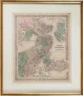 "COLTON'S BOSTON AND ADJACENT
 CITIES." MAP 19TH CENTURY 17" X 14" SIGHT. FRAMED 23" X 20"."COLTON'S BOSTON AND ADJACENT CITIES." MAP, 19th Century, From Colton's General Atlas, 1855. Dimensions: 17" x 14" sight. Framed 23" x 20".
"COLTON'S BOSTON AND ADJACENT
"COLTON'S BOSTON AND ADJACENT CITIES." MAP 19TH CENTURY 17" X 14" SIGHT. FRAMED 23" X 20"."COLTON'S BOSTON AND ADJACENT CITIES." MAP, 19th Century, From Colton's General Atlas, 1855. Dimensions: 17" x 14" sight. Framed 23" x 20". -
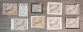
 J. H. COLTON & CO. AND OTHER
 PUBLISHERS, 15 COLOR ENGRAVED MAPS OF AMERICA, EUROPE AND OTHER AREAS, EACH UNFRAMED: LARGEST 13 1/2 X 17 1/2 IN. (34.29 X 44.45 CM.)J. H. Colton & Co. and Other Publishers, 15 Color Engraved Maps of America, Europe and Other Areas,, Dimensions: Each unframed: largest 13 1/2 x 17 1/2 in. (34.29 x 44.45 cm.)
J. H. COLTON & CO. AND OTHER
J. H. COLTON & CO. AND OTHER PUBLISHERS, 15 COLOR ENGRAVED MAPS OF AMERICA, EUROPE AND OTHER AREAS, EACH UNFRAMED: LARGEST 13 1/2 X 17 1/2 IN. (34.29 X 44.45 CM.)J. H. Colton & Co. and Other Publishers, 15 Color Engraved Maps of America, Europe and Other Areas,, Dimensions: Each unframed: largest 13 1/2 x 17 1/2 in. (34.29 x 44.45 cm.) -
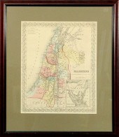 Hand colored map of Palestine by
 J.H. Colton & Co. New York. 16"x13"
Hand colored map of Palestine by
Hand colored map of Palestine by J.H. Colton & Co. New York. 16"x13" -
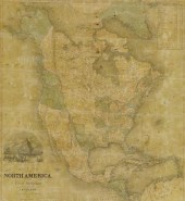 FRAMED J.H. COLTON MAP OF NORTH
 AMERICA CA INSETFramed engraving on paper, Map of North America from the Latest Authorities, published by J.H. Colton (Joseph Hutchins Colton, 1800-1893), No. 86 Cedar St., New York, 1846, drawn and engraved by J.M. Atwood (John M. Atwood, b. ca. 1818), New York, with inset vignette of Pyramid Lake, upper California, sight: 24"h, 22"w, overall: 36.25"h, 34.25"w, 15lbs
FRAMED J.H. COLTON MAP OF NORTH
FRAMED J.H. COLTON MAP OF NORTH AMERICA CA INSETFramed engraving on paper, Map of North America from the Latest Authorities, published by J.H. Colton (Joseph Hutchins Colton, 1800-1893), No. 86 Cedar St., New York, 1846, drawn and engraved by J.M. Atwood (John M. Atwood, b. ca. 1818), New York, with inset vignette of Pyramid Lake, upper California, sight: 24"h, 22"w, overall: 36.25"h, 34.25"w, 15lbs -
 LOT OF 9 MAPS OF JAPAN3 Colton, 5
 Johnson, and 1 Fullarton and Co. maps. Ranging from 1855-1860. Largest: 15 1/4" H x 22 5/8" L. Fullarton and Co are not mounted. The rest are mounted. Slight foxing to paper.
LOT OF 9 MAPS OF JAPAN3 Colton, 5
LOT OF 9 MAPS OF JAPAN3 Colton, 5 Johnson, and 1 Fullarton and Co. maps. Ranging from 1855-1860. Largest: 15 1/4" H x 22 5/8" L. Fullarton and Co are not mounted. The rest are mounted. Slight foxing to paper. -
 G.W. & J.H. COLTON "MAP OF THE
 COUNTRY THIRTY THREE MIL...G.W. & J.H. Colton "Map of the Country Thirty Three Miles Around the City of New York" hand colored engraving, published New York, 1855 by J.H. Colton; drawn by G. W. Colton, engraved by J.M. Atwood "Entered According to Congress in the Year 1846...", matted and framed 24.25 in. x 22.5 in. Framed 32.75 in. x 30 in. Condition: Items may have wear and tear, imperfections or the effects of aging. Please contact the gallery for further details prior to bidding. Any condition statement given as a courtesy should not be treated as fact.
G.W. & J.H. COLTON "MAP OF THE
G.W. & J.H. COLTON "MAP OF THE COUNTRY THIRTY THREE MIL...G.W. & J.H. Colton "Map of the Country Thirty Three Miles Around the City of New York" hand colored engraving, published New York, 1855 by J.H. Colton; drawn by G. W. Colton, engraved by J.M. Atwood "Entered According to Congress in the Year 1846...", matted and framed 24.25 in. x 22.5 in. Framed 32.75 in. x 30 in. Condition: Items may have wear and tear, imperfections or the effects of aging. Please contact the gallery for further details prior to bidding. Any condition statement given as a courtesy should not be treated as fact. -
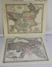 2 COLTON'S MAPS OF TURKEY, 1855.
 ONE IS TURKEYIN ASIA THE OTHER IS TURKEY IN EUROPE. THEY HAVE SOME HAND COLORING AND ARE IN FAIR CONDITION. SHOWS SMALL TEARS INTO THE BORDERS AND SOME CHIPPING ON THE EDGES. 15" X 18". PROVENANCE: FAIRHAVEN COLONIAL CLUB.
2 COLTON'S MAPS OF TURKEY, 1855.
2 COLTON'S MAPS OF TURKEY, 1855. ONE IS TURKEYIN ASIA THE OTHER IS TURKEY IN EUROPE. THEY HAVE SOME HAND COLORING AND ARE IN FAIR CONDITION. SHOWS SMALL TEARS INTO THE BORDERS AND SOME CHIPPING ON THE EDGES. 15" X 18". PROVENANCE: FAIRHAVEN COLONIAL CLUB. -
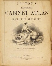 2 vols. American 19th-Century
 Atlases: Colton's Illustrated Cabinet Atlas and Descriptive Geography. New York: J.H. Colton, 1859. Folio, orig. morocco & cloth; rubbed & worn, spine defective, front cover detached. With ca. 45 sheets of colored maps & c., numerous wood-engraved text illus. Title page creased. A few wood-engravings clipped. * Colton's General Atlas. New York: G.W. & C.B. Colton, 1872. Folio, orig. morocco & cloth; rubbed & worn, spine defective, covers detached. With ca. 126 (of 129) sheets of colored maps - lacking vignette title & flag sheets. Title page & front matter detached, defects to title page & index. Occasionally slightly toned. Sold with all faults.
2 vols. American 19th-Century
2 vols. American 19th-Century Atlases: Colton's Illustrated Cabinet Atlas and Descriptive Geography. New York: J.H. Colton, 1859. Folio, orig. morocco & cloth; rubbed & worn, spine defective, front cover detached. With ca. 45 sheets of colored maps & c., numerous wood-engraved text illus. Title page creased. A few wood-engravings clipped. * Colton's General Atlas. New York: G.W. & C.B. Colton, 1872. Folio, orig. morocco & cloth; rubbed & worn, spine defective, covers detached. With ca. 126 (of 129) sheets of colored maps - lacking vignette title & flag sheets. Title page & front matter detached, defects to title page & index. Occasionally slightly toned. Sold with all faults. -
 A CIVIL WAR ERA MAP, "JOHNSON'S
 CALIFORNIA WITH TERRITO...A CIVIL WAR ERA MAP, "Johnson's California with Territories of Utah, Nevada, Colorado, New Mexico and Arizona," NEW YORK, CIRCA 1866, colored cerography on paper, a fragment from Johnson's Family Atlas, "Published by Johnson and Ward," "Entered According to Act of Congress in year 1864 by A.J. Johnson in the Clerk's Office of the District of the United States for the southern district of New York," plates 66 and 67, within an interlocking fretwork border with military star corners; the map showing the "Proposed Pacific R.R.," "Proposed Union Pacific R.R.," the Pony Express route, Cimarron route, Fremont routes, lakes, geological features with elevation show in hachures, cities, towns, springs, Indigenous lands, Reservations, political areas, boundary/treaty lines with dates and mineral mining notes. 18" x 24 1/2" Provenance: Property from a Corporate Collection, Houston, Texas. Property from a Corporate Collection, Houston, Texas Condition: Foxing spots, not a colorful example and the blue is somewhat faded, mild yellow, overall in good to very good condition, wear commensurate with age. Simpson Galleries strongly encourages in-person inspection of items by the bidder. Statements by Simpson Galleries regarding the condition of objects are for guidance only and should not be relied upon as statements of fact and do not constitute a representation, warranty, or assumption of liability by Simpson Galleries. All lots offered are sold "AS IS.” NO REFUNDS will be issued based on condition.
A CIVIL WAR ERA MAP, "JOHNSON'S
A CIVIL WAR ERA MAP, "JOHNSON'S CALIFORNIA WITH TERRITO...A CIVIL WAR ERA MAP, "Johnson's California with Territories of Utah, Nevada, Colorado, New Mexico and Arizona," NEW YORK, CIRCA 1866, colored cerography on paper, a fragment from Johnson's Family Atlas, "Published by Johnson and Ward," "Entered According to Act of Congress in year 1864 by A.J. Johnson in the Clerk's Office of the District of the United States for the southern district of New York," plates 66 and 67, within an interlocking fretwork border with military star corners; the map showing the "Proposed Pacific R.R.," "Proposed Union Pacific R.R.," the Pony Express route, Cimarron route, Fremont routes, lakes, geological features with elevation show in hachures, cities, towns, springs, Indigenous lands, Reservations, political areas, boundary/treaty lines with dates and mineral mining notes. 18" x 24 1/2" Provenance: Property from a Corporate Collection, Houston, Texas. Property from a Corporate Collection, Houston, Texas Condition: Foxing spots, not a colorful example and the blue is somewhat faded, mild yellow, overall in good to very good condition, wear commensurate with age. Simpson Galleries strongly encourages in-person inspection of items by the bidder. Statements by Simpson Galleries regarding the condition of objects are for guidance only and should not be relied upon as statements of fact and do not constitute a representation, warranty, or assumption of liability by Simpson Galleries. All lots offered are sold "AS IS.” NO REFUNDS will be issued based on condition. -
 Christopher
 Saxton/Brecknoc/Glamorgan/two hand coloured maps, 27cm x 34cm
Christopher
Christopher Saxton/Brecknoc/Glamorgan/two hand coloured maps, 27cm x 34cm -
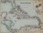
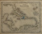 COLTON'S WEST INDIES, COLOR
 ENGRAVED MAP, FRAME: 18 3/4 X 21 1/2 IN. (47.63 X 54.61 CM.)Colton's West Indies, Color Engraved Map,, Dimensions: Frame: 18 3/4 x 21 1/2 in. (47.63 x 54.61 cm.)
COLTON'S WEST INDIES, COLOR
COLTON'S WEST INDIES, COLOR ENGRAVED MAP, FRAME: 18 3/4 X 21 1/2 IN. (47.63 X 54.61 CM.)Colton's West Indies, Color Engraved Map,, Dimensions: Frame: 18 3/4 x 21 1/2 in. (47.63 x 54.61 cm.) -
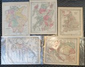
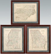 Three 1855 Southern maps: "North
 Carolina", "Georgia" and "Mississippi", published by J. H. Colton and Company, 1855, each hand colored, about 17 x 13-1/2 in.; separately mounted in modern wood frames. Fading to colors, light toning, minor edge losses, archival tape mounts at tops on reverses. Couey Collection.
Three 1855 Southern maps: "North
Three 1855 Southern maps: "North Carolina", "Georgia" and "Mississippi", published by J. H. Colton and Company, 1855, each hand colored, about 17 x 13-1/2 in.; separately mounted in modern wood frames. Fading to colors, light toning, minor edge losses, archival tape mounts at tops on reverses. Couey Collection. -
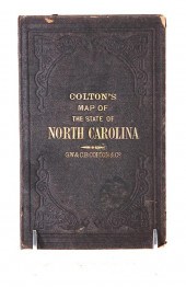 Travel maps of North and South
 Carolina consisting of: COLTON'S MAP OF THE STATE OF NORTH CAROLINA WITH PORTIONS OF ADJOINING STATES 1866. Late 19th century in two parts folded and mounted within hardcover book; THE RAND-MCNALLY VEST POCKET MAP OF SOUTH CAROLINA 1913. New York: Rand McNally & Co. 1913. Folded and mounted within soft paper folded case. STANDARD ROAD MAP OF NORTH CAROLINA AND SOUTH CAROLINA. Published by the Standard Oil Company of New Jersey unframed. H17 1/2'' W23 5/8'' (3pcs) Provenance: Columbia South Carolina private collection. Colton’s: multiple tears and staining along creases. Rand-McNally: tears along creases; paper toned. Standard: good original condition with small tear at left margin.
Travel maps of North and South
Travel maps of North and South Carolina consisting of: COLTON'S MAP OF THE STATE OF NORTH CAROLINA WITH PORTIONS OF ADJOINING STATES 1866. Late 19th century in two parts folded and mounted within hardcover book; THE RAND-MCNALLY VEST POCKET MAP OF SOUTH CAROLINA 1913. New York: Rand McNally & Co. 1913. Folded and mounted within soft paper folded case. STANDARD ROAD MAP OF NORTH CAROLINA AND SOUTH CAROLINA. Published by the Standard Oil Company of New Jersey unframed. H17 1/2'' W23 5/8'' (3pcs) Provenance: Columbia South Carolina private collection. Colton’s: multiple tears and staining along creases. Rand-McNally: tears along creases; paper toned. Standard: good original condition with small tear at left margin. -
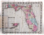 1856 MAP OF FLORIDA COLTON,
 HAND-COLOREDAntebellum, dated 1856 folding map of Florida published by J.H.Colton, hand-colored and in magnificent condition. Book measures 5" x 3-1/2". Map extends to nearly 17" wide. Part of a large estate collection of Florida antiques, some of which is offered in today's auction.
1856 MAP OF FLORIDA COLTON,
1856 MAP OF FLORIDA COLTON, HAND-COLOREDAntebellum, dated 1856 folding map of Florida published by J.H.Colton, hand-colored and in magnificent condition. Book measures 5" x 3-1/2". Map extends to nearly 17" wide. Part of a large estate collection of Florida antiques, some of which is offered in today's auction. -
 (2) ANTIQUE HAND-COLORED
 CELESTIAL MAPS Later editions, Joannes Janssonius, "Haemisphaerium Scenographicum Australe Coeli Stellati et Terra", originally published 1660, appears to be on laid paper; with, Andreas Cellarius, "Soliscirca Orbem Terrarum Spiralis Revolutio", originally published 1661, appears to be on wove paper; each, 17.5"h x 20"w (sight), 22.5"h x 25.5"w (frame)
(2) ANTIQUE HAND-COLORED
(2) ANTIQUE HAND-COLORED CELESTIAL MAPS Later editions, Joannes Janssonius, "Haemisphaerium Scenographicum Australe Coeli Stellati et Terra", originally published 1660, appears to be on laid paper; with, Andreas Cellarius, "Soliscirca Orbem Terrarum Spiralis Revolutio", originally published 1661, appears to be on wove paper; each, 17.5"h x 20"w (sight), 22.5"h x 25.5"w (frame) -
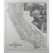 MAP, HENRY SMITH CROCKER Henry
 Smith Crocker (American, 1832-1904), "The Geographical Map of the State of California Compiled from Actual Surveys, 1893," engraved map, published by H.S. Crocker Company, overall (with mat): 35"h x 30"w
MAP, HENRY SMITH CROCKER Henry
MAP, HENRY SMITH CROCKER Henry Smith Crocker (American, 1832-1904), "The Geographical Map of the State of California Compiled from Actual Surveys, 1893," engraved map, published by H.S. Crocker Company, overall (with mat): 35"h x 30"w -
 4 TN & KY MAPS, 3 FRAMED1st item:
 "Tennessee" Map, by Anthony Finley, engraved by Young and Delleker, published by Anthony Finley, Philadelphia, 1824. From "A New General Atlas, Comprising a Complete Set of Maps" by Anthony Finley. Copper plate engraving with hand coloring of Tennessee depicting towns and roads, county lines, names of counties, rivers, mountains, and railroads. Title, top center, scale of miles, bottom center. "Longitude West from Washington", centered above map, "Longitude West from Greenwich", centered below map. Map surrounded by scale notations and triple line border. Housed in a wooden frame with matte. Image - 8 3/8" H x 11 1/2" W. Sight - 8 3/4" H x 11 3/4" W. Framed - 14 1/8" H x 17 1/4" W. 2nd item: "Kentucky and Tennessee" Map, by Thomas Illman after David Burr, published by William Hall and Company, New York, 1836. From "A New Universal Atlas" by David Burr. Copper plate engraving with hand colored outlines of Kentucky and Tennessee depicting towns and roads, county lines, names of counties, rivers, mountains, and railroads. Title and scale of miles, top left. "Longitude West from Greenwich", centered above map, "Longitude West from Washington", centered below map. Map surrounded by scale notations and triple line border. Housed in a black wooden frame with matte. Image - 10 1/2" H x 12 1/8" W. Sight - 11 1/2" H x 13 1/8" W. Framed - 17 3/4" H x 19 1/4" W. 3rd item: "Kentucky and Tennessee" Map, by George W. Colton, published by Joseph H. Colton and Company, New York, c. 1857. From "Colton's General Atlas" by Joseph H. Colton. Steel plate engraving with hand coloring of Kentucky and Tennessee depicting towns and roads, county lines, names of counties, rivers, mountains, and railroads. "The State of Ohio" text page en verso. Title, scale of miles, and explanations, top left. "Longitude West from Greenwich", centered above map, "Longitude West from Washington", centered below map. Map surrounded by scale notations and triple line border. Housed in sealed plastic sleeve. Image - 11 3/4" H x 16 1/2" W. Sheet - 14" H x 17" W. Sleeve - 16" H x 19" W. 4th item: "J. H. Colton's Map of Kentucky and Tennessee", by Joseph H. Colton, published by Johnson and Ward, New York, 1863. From "A Chronological History of the Civil War in America" by Richard S. Fisher. Steel plate engraving with hand coloring of Kentucky and Tennessee depicting towns and roads, county lines, names of counties, rivers, mountains, and railroads. Title and scale of miles, top left. Map surrounded by scale notations and double line border. Housed in a black wooden frame with matte. Image - 7 5/8" H x 10 1/8" W. Sight - 8 1/8" H x 10 5/8" W. Framed - 13 3/8" H x 16" W. All items early/mid 19th century. Provenance: Collection of Charles and Ann Wells, Nashville, Tennessee. (Higher-resolution photos are available at www.caseantiques.com) Condition: 1st item: Foxing spots, largest 14" lower right, on surface of sheet. Not examined outside of frame. 2nd item: Two minute foxing spots, top left and right on surface of sheet. Wrinkling on surface of sheet. Not examined outside of frame. 3rd item: Toning around edges of sheet. Minute foxing spots on surface of sheet. Paper tears, largest 1/4" top left, on top edge of sheet. Toning and foxing spots visible en verso. 4th item: Two minute foxing spots, top and bottom right on surface of sheet. Not examined outside of frame.
4 TN & KY MAPS, 3 FRAMED1st item:
4 TN & KY MAPS, 3 FRAMED1st item: "Tennessee" Map, by Anthony Finley, engraved by Young and Delleker, published by Anthony Finley, Philadelphia, 1824. From "A New General Atlas, Comprising a Complete Set of Maps" by Anthony Finley. Copper plate engraving with hand coloring of Tennessee depicting towns and roads, county lines, names of counties, rivers, mountains, and railroads. Title, top center, scale of miles, bottom center. "Longitude West from Washington", centered above map, "Longitude West from Greenwich", centered below map. Map surrounded by scale notations and triple line border. Housed in a wooden frame with matte. Image - 8 3/8" H x 11 1/2" W. Sight - 8 3/4" H x 11 3/4" W. Framed - 14 1/8" H x 17 1/4" W. 2nd item: "Kentucky and Tennessee" Map, by Thomas Illman after David Burr, published by William Hall and Company, New York, 1836. From "A New Universal Atlas" by David Burr. Copper plate engraving with hand colored outlines of Kentucky and Tennessee depicting towns and roads, county lines, names of counties, rivers, mountains, and railroads. Title and scale of miles, top left. "Longitude West from Greenwich", centered above map, "Longitude West from Washington", centered below map. Map surrounded by scale notations and triple line border. Housed in a black wooden frame with matte. Image - 10 1/2" H x 12 1/8" W. Sight - 11 1/2" H x 13 1/8" W. Framed - 17 3/4" H x 19 1/4" W. 3rd item: "Kentucky and Tennessee" Map, by George W. Colton, published by Joseph H. Colton and Company, New York, c. 1857. From "Colton's General Atlas" by Joseph H. Colton. Steel plate engraving with hand coloring of Kentucky and Tennessee depicting towns and roads, county lines, names of counties, rivers, mountains, and railroads. "The State of Ohio" text page en verso. Title, scale of miles, and explanations, top left. "Longitude West from Greenwich", centered above map, "Longitude West from Washington", centered below map. Map surrounded by scale notations and triple line border. Housed in sealed plastic sleeve. Image - 11 3/4" H x 16 1/2" W. Sheet - 14" H x 17" W. Sleeve - 16" H x 19" W. 4th item: "J. H. Colton's Map of Kentucky and Tennessee", by Joseph H. Colton, published by Johnson and Ward, New York, 1863. From "A Chronological History of the Civil War in America" by Richard S. Fisher. Steel plate engraving with hand coloring of Kentucky and Tennessee depicting towns and roads, county lines, names of counties, rivers, mountains, and railroads. Title and scale of miles, top left. Map surrounded by scale notations and double line border. Housed in a black wooden frame with matte. Image - 7 5/8" H x 10 1/8" W. Sight - 8 1/8" H x 10 5/8" W. Framed - 13 3/8" H x 16" W. All items early/mid 19th century. Provenance: Collection of Charles and Ann Wells, Nashville, Tennessee. (Higher-resolution photos are available at www.caseantiques.com) Condition: 1st item: Foxing spots, largest 14" lower right, on surface of sheet. Not examined outside of frame. 2nd item: Two minute foxing spots, top left and right on surface of sheet. Wrinkling on surface of sheet. Not examined outside of frame. 3rd item: Toning around edges of sheet. Minute foxing spots on surface of sheet. Paper tears, largest 1/4" top left, on top edge of sheet. Toning and foxing spots visible en verso. 4th item: Two minute foxing spots, top and bottom right on surface of sheet. Not examined outside of frame. -
 J.H. COLTON MAP OF THE WEST
 INDIES 1855Map of the West Indies, published by J.H. Colton & Co., New York, circa 1855. 21 1/2" x 27 1/2" (with frame 30" x 36"). Foxing and discoloration
J.H. COLTON MAP OF THE WEST
J.H. COLTON MAP OF THE WEST INDIES 1855Map of the West Indies, published by J.H. Colton & Co., New York, circa 1855. 21 1/2" x 27 1/2" (with frame 30" x 36"). Foxing and discoloration -
 4 EARLY AMERICAN MAPS: OVERTON,
 THIERRY, CAPTAIN COOK, ...1st item: AN ACCURATE MAP OF THE ENGLISH COLONIES IN NORTH AMERICA BORDERING ON THE RIVER OHIO. Printed map describing New England, New York, New Jersey, Pennsylvania, Maryland, Virginia, North Carolina and Carolina, the Appalachian Mountains, and the Great Lakes as far as Lake Michigan. Tribal lands including those of the Cherokee, Miami, and Iroquois are also noted. With unusual north-south boundary lines as opposed to the now standard westward lines. Published in The Universal Magazine of Knowledge and Pleasure, London, 1754. This map is a truncated version of the undated broadside map of the same name published by Henry Overton earlier in 1754. Housed in a plastic sleeve with print-outs of text from The Universal Magazine and a description of the map. Sheet: 8" H x 10" W. Sleeve: 17 6/16" H x 15 1/4" W. 2nd item: CARTE DES ETATS-UNIS D'AMERIQUE. Hand-colored French map describing the United States just prior to Texas declaring its independence from Mexico, with Missouri Territory extending from Arkansas and Missouri to the Pacific Ocean and Canadian boundary extending into modern-day British Columbia. Two spurious rivers in Utah's Great Basin connect Lake Timpanogos and Lake Teguayo to the Pacific Ocean. Published in Geographie Moderne, Paris, c. 1835, by Thierry. Plate: 10" H x 13" W. Sheet: 11 5/8" H x 15" W. 3rd item: A CHART OF THE WORLD, ACCORDING TO MERCATORS PROJECTION SHEWING THE LATEST DISCOVERIES OF CAPT. COOK. Hand-colored map of the world charting the three voyages of Captain James Cook, first on the HMS Endeavor and later the HMS Resolution. With defunct American locations including Sir Francis Drake's New Albion, New Louisiana, and East and West Florida. Published by C. Dilly and G. Robinson, London, 1785. 16 1/4" H x 21" W. 4th item: NORTH AMERICA SHEET VI NEW YORK, VERMONT, MAINE, NEW HAMPSHIRE, MASSACHUSETTS, CONNECTICUT, RHODE ISLAND, AND NEW JERSEY. Hand-colored and exceptionally detailed map describing the titular states along the North Atlantic coast. Published by the Society for the Diffusion of Useful Knowledge and by Baldwin & Cradock, London, 1832. 15 7/8" H x 13 5/16" W. Condition: 1st item: Overall excellent condition. Some of the upper right and lower left marginal border lines are missing along with part of the 65 longitudinal degree. Missing areas have been replicated in pencil on adhered paper. 2nd item: Very good condition with wide margins. Some pencil notations and slight foxing throughout and losses to lower edge of sheet. 3rd item: Overall good condition, with folds and reinforcement affixed to verso to stabilize partially torn fold line at center left. Some staining and pencil notations. 4th item: Overall excellent condition, with negligible, scattered foxing and pencil inscriptions to upper left corner and verso.
4 EARLY AMERICAN MAPS: OVERTON,
4 EARLY AMERICAN MAPS: OVERTON, THIERRY, CAPTAIN COOK, ...1st item: AN ACCURATE MAP OF THE ENGLISH COLONIES IN NORTH AMERICA BORDERING ON THE RIVER OHIO. Printed map describing New England, New York, New Jersey, Pennsylvania, Maryland, Virginia, North Carolina and Carolina, the Appalachian Mountains, and the Great Lakes as far as Lake Michigan. Tribal lands including those of the Cherokee, Miami, and Iroquois are also noted. With unusual north-south boundary lines as opposed to the now standard westward lines. Published in The Universal Magazine of Knowledge and Pleasure, London, 1754. This map is a truncated version of the undated broadside map of the same name published by Henry Overton earlier in 1754. Housed in a plastic sleeve with print-outs of text from The Universal Magazine and a description of the map. Sheet: 8" H x 10" W. Sleeve: 17 6/16" H x 15 1/4" W. 2nd item: CARTE DES ETATS-UNIS D'AMERIQUE. Hand-colored French map describing the United States just prior to Texas declaring its independence from Mexico, with Missouri Territory extending from Arkansas and Missouri to the Pacific Ocean and Canadian boundary extending into modern-day British Columbia. Two spurious rivers in Utah's Great Basin connect Lake Timpanogos and Lake Teguayo to the Pacific Ocean. Published in Geographie Moderne, Paris, c. 1835, by Thierry. Plate: 10" H x 13" W. Sheet: 11 5/8" H x 15" W. 3rd item: A CHART OF THE WORLD, ACCORDING TO MERCATORS PROJECTION SHEWING THE LATEST DISCOVERIES OF CAPT. COOK. Hand-colored map of the world charting the three voyages of Captain James Cook, first on the HMS Endeavor and later the HMS Resolution. With defunct American locations including Sir Francis Drake's New Albion, New Louisiana, and East and West Florida. Published by C. Dilly and G. Robinson, London, 1785. 16 1/4" H x 21" W. 4th item: NORTH AMERICA SHEET VI NEW YORK, VERMONT, MAINE, NEW HAMPSHIRE, MASSACHUSETTS, CONNECTICUT, RHODE ISLAND, AND NEW JERSEY. Hand-colored and exceptionally detailed map describing the titular states along the North Atlantic coast. Published by the Society for the Diffusion of Useful Knowledge and by Baldwin & Cradock, London, 1832. 15 7/8" H x 13 5/16" W. Condition: 1st item: Overall excellent condition. Some of the upper right and lower left marginal border lines are missing along with part of the 65 longitudinal degree. Missing areas have been replicated in pencil on adhered paper. 2nd item: Very good condition with wide margins. Some pencil notations and slight foxing throughout and losses to lower edge of sheet. 3rd item: Overall good condition, with folds and reinforcement affixed to verso to stabilize partially torn fold line at center left. Some staining and pencil notations. 4th item: Overall excellent condition, with negligible, scattered foxing and pencil inscriptions to upper left corner and verso. -
 1 piece. Colored Lithographic Fold
 Map. Froiseth, B.A.M. "Maps of Utah Territory, Great Salt Lake Valley and Salt Lake City" - casing title. New York: Am. Photo-lithographic Co., 1870. 16 3/4 x 13 3/4 inches (425 x 350 mm). In orig. gilt-lettered terra-cotta cloth casing - "Published by Skandinavish Post, N.Y." Occasional minor staining, but generally crisp & bright. 3 maps on 1 sheet, with portrait of Bringham Young. Phillips, Maps of America, 1901, p.
1 piece. Colored Lithographic Fold
1 piece. Colored Lithographic Fold Map. Froiseth, B.A.M. "Maps of Utah Territory, Great Salt Lake Valley and Salt Lake City" - casing title. New York: Am. Photo-lithographic Co., 1870. 16 3/4 x 13 3/4 inches (425 x 350 mm). In orig. gilt-lettered terra-cotta cloth casing - "Published by Skandinavish Post, N.Y." Occasional minor staining, but generally crisp & bright. 3 maps on 1 sheet, with portrait of Bringham Young. Phillips, Maps of America, 1901, p. -
 1874 COLTON'S GENERAL ATLAS New
 York,1874"Colton's General Atlas with Descriptions" with maps drawn by G. Woolworth Colton, descriptions by Richard Swainson Fisher, published by G.W. & C. B. Colton & Co. in 1874.
1874 COLTON'S GENERAL ATLAS New
1874 COLTON'S GENERAL ATLAS New York,1874"Colton's General Atlas with Descriptions" with maps drawn by G. Woolworth Colton, descriptions by Richard Swainson Fisher, published by G.W. & C. B. Colton & Co. in 1874. -
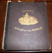
 COLTON'S ATLAS OF THE WORLD, 2
 LARGE CLOTH BOUNDVOLUMES, 19 1/4" X 17". PUBLISHED BY J. H. COLTON, NEW YORK, 1856. VOLUME ONE CONTAINS 63 PLATES WITH GEOGRAPHICAL, STATISTICAL AND HISTORICAL INFORMATION. THE OVERALL CONDITION IS GOOD WITH SOME FOXING AND STAINING AND A FEW SMALL TEARS. THE SPINE IS BADLY SPLIT AND BOARDS SHOW WEAR. VOLUME TWO CONTAINS 36 MAPS. THE CONDITION IS GOOD WITH SOME FOXING AND STAINING. SPINE IS SPLIT AND BOARDS SHOW WEAR.
COLTON'S ATLAS OF THE WORLD, 2
COLTON'S ATLAS OF THE WORLD, 2 LARGE CLOTH BOUNDVOLUMES, 19 1/4" X 17". PUBLISHED BY J. H. COLTON, NEW YORK, 1856. VOLUME ONE CONTAINS 63 PLATES WITH GEOGRAPHICAL, STATISTICAL AND HISTORICAL INFORMATION. THE OVERALL CONDITION IS GOOD WITH SOME FOXING AND STAINING AND A FEW SMALL TEARS. THE SPINE IS BADLY SPLIT AND BOARDS SHOW WEAR. VOLUME TWO CONTAINS 36 MAPS. THE CONDITION IS GOOD WITH SOME FOXING AND STAINING. SPINE IS SPLIT AND BOARDS SHOW WEAR. -
 COLTON NORTHWESTERN U.S.
 HAND-COLORED ENGRAVING "Colton's Oregon, Washington, Idaho, Montana, and British Columbia," hand-colored engraving, published by G.W. and C.B. Colton, No. 172 Williams St. New York. Image: 17" H x 27" W; frame: 26" H x 36" W
COLTON NORTHWESTERN U.S.
COLTON NORTHWESTERN U.S. HAND-COLORED ENGRAVING "Colton's Oregon, Washington, Idaho, Montana, and British Columbia," hand-colored engraving, published by G.W. and C.B. Colton, No. 172 Williams St. New York. Image: 17" H x 27" W; frame: 26" H x 36" W -
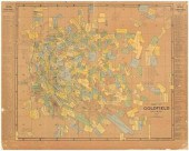 "Map of Goldfield Nevada 1907",
 published by the Clason Map Co., Denver, Colorado, claims shown for numerous mining companies including "Hardtack Group, Nevada Boy, Doctor Gold, Ready Money Group", imprinted with "Compliments of the H. A. Riedel Investment Company" lower margin, 21-5/8 x 27 in. Small surface losses (mostly at edges), corner creases and tack holes, folds, laid down on heavy paperboard. Private Collection
"Map of Goldfield Nevada 1907",
"Map of Goldfield Nevada 1907", published by the Clason Map Co., Denver, Colorado, claims shown for numerous mining companies including "Hardtack Group, Nevada Boy, Doctor Gold, Ready Money Group", imprinted with "Compliments of the H. A. Riedel Investment Company" lower margin, 21-5/8 x 27 in. Small surface losses (mostly at edges), corner creases and tack holes, folds, laid down on heavy paperboard. Private Collection
...many more examples with full details are available to our members - Learn more
Easy & Visual methods to Identify & Appraise Antiques & Collectibles
EASY. FAST. ACCURATE.
Research at its best
We are here to help!
Our research tools include:

Thousands of makers marks for PORCELAIN, POTTERY CHINAWARE, FIGURINES, VASES
see details...

Thousands of marks & hallmarks for SILVER & JEWELRY, PEWTER, PRECIOUS METALS, SILVERPLATE
see details...
