Pricing Guides & Dictionary of Makers Marks for Antiques & Collectibles
A few examples of appraisal values for
CORNWALLIS
Search our price guide for your own treasures
-
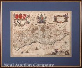
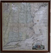
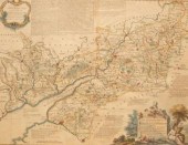
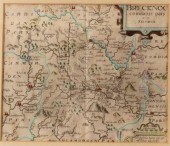
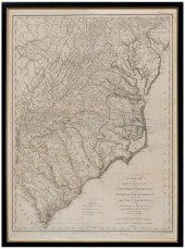 18th century map of eastern
 United States, "The Marches of Lord Cornwallis in the Southern Provinces, now States of North America; Comprehending the Two Carolinas, with Virginia and Maryland, and the Delaware Counties. By William Faden, Geographer to the King", published in A History of the Campaigns of 1780 and 1781, in the Southern Provinces of North America , by Lieut. Col. Banastre Tarleton, London, 1787, showing three different march routes hand traced in color, engraving on laid paper, 26-1/2 x 19-3/4 in. (page); modern wood frame. Laid down on acidic card, toning, light foxing, stains, creases, fading, trimmed including portion of plate marks, 1-1/2 in. repaired tear at bottom, other possible repairs in bottom margin; frame with abrasions. Estate of the Late Nathan and Mary Anne McCarley, Asheville, North Carolina.
18th century map of eastern
18th century map of eastern United States, "The Marches of Lord Cornwallis in the Southern Provinces, now States of North America; Comprehending the Two Carolinas, with Virginia and Maryland, and the Delaware Counties. By William Faden, Geographer to the King", published in A History of the Campaigns of 1780 and 1781, in the Southern Provinces of North America , by Lieut. Col. Banastre Tarleton, London, 1787, showing three different march routes hand traced in color, engraving on laid paper, 26-1/2 x 19-3/4 in. (page); modern wood frame. Laid down on acidic card, toning, light foxing, stains, creases, fading, trimmed including portion of plate marks, 1-1/2 in. repaired tear at bottom, other possible repairs in bottom margin; frame with abrasions. Estate of the Late Nathan and Mary Anne McCarley, Asheville, North Carolina. -
 Two colored engravings 19th
 century, "Engraved for Barnard's New Complete and Authentic History of England" One showing the "Surrender of Earl Cornwallis," the other, "The Manner in which the AMerican Colonies Declared themselves Independent of the King of England" Sight size: 13 x 8 3/
Two colored engravings 19th
Two colored engravings 19th century, "Engraved for Barnard's New Complete and Authentic History of England" One showing the "Surrender of Earl Cornwallis," the other, "The Manner in which the AMerican Colonies Declared themselves Independent of the King of England" Sight size: 13 x 8 3/ -
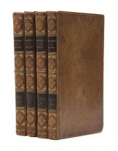 (ENGLAND) CROMWELL THOMAS KITSON
 Excursions in the County of Suffolk 2 vols. [uniformly bound with:] Excursions in the County of Essex 2 vols. London: Printed for Longman et al. 1818. 4 vols. 8vo contemporary calf spines tooled in gilt titles in gilt to leather spine labels. With 192 engraved plates and three fold-out maps. Rubbing to boards; joints cracked; front board vol. 1 loose; foxing; light offsetting from some plates; manuscript pen inscription to f.f.e.p. all vols.
(ENGLAND) CROMWELL THOMAS KITSON
(ENGLAND) CROMWELL THOMAS KITSON Excursions in the County of Suffolk 2 vols. [uniformly bound with:] Excursions in the County of Essex 2 vols. London: Printed for Longman et al. 1818. 4 vols. 8vo contemporary calf spines tooled in gilt titles in gilt to leather spine labels. With 192 engraved plates and three fold-out maps. Rubbing to boards; joints cracked; front board vol. 1 loose; foxing; light offsetting from some plates; manuscript pen inscription to f.f.e.p. all vols. -
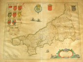 Willem Blaeu, Cornubia five
 Cornwallia, French text, map of Cornwall, engraved, hand colored, decorated with large coats of arms and smaller shields, browned, no tears, 15 1/4" x 19 3/4" image, Latin text verso Estimate $300-500
Willem Blaeu, Cornubia five
Willem Blaeu, Cornubia five Cornwallia, French text, map of Cornwall, engraved, hand colored, decorated with large coats of arms and smaller shields, browned, no tears, 15 1/4" x 19 3/4" image, Latin text verso Estimate $300-500 -
 A map of Cornwall from the Best
 Authorities, engraved by John Cary, published by John Stockdale, Piccadilly 26th March 1805, 41cm x 53cm
A map of Cornwall from the Best
A map of Cornwall from the Best Authorities, engraved by John Cary, published by John Stockdale, Piccadilly 26th March 1805, 41cm x 53cm -
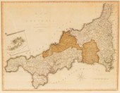
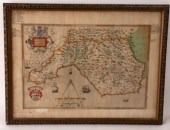
 Christopher Saxton
 (1540-1610)/Warwici Countatus Cornaviis Olim Inhabitus/first edition 1607, text on reverse/coloured engraved map, 28.5cm x 30.5cm
Christopher Saxton
Christopher Saxton (1540-1610)/Warwici Countatus Cornaviis Olim Inhabitus/first edition 1607, text on reverse/coloured engraved map, 28.5cm x 30.5cm -
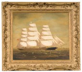 English Painting (ca. 1865-1870)
 Clipper Ship Cornwallis Oil on canvas portrait of the three-master Cornwallis a British cargo ship that wrecked in the Pitcairn Islands in 1877 signed E.J.P.; 19.5 x 23.25 in. Estate of Thomas Fred Jackson II Augusta Kentucky Condition: Surface dirt. At one time canvas was restretched but never relined. Very light inpainting along perimeter and also very light touch-up to the sea.
English Painting (ca. 1865-1870)
English Painting (ca. 1865-1870) Clipper Ship Cornwallis Oil on canvas portrait of the three-master Cornwallis a British cargo ship that wrecked in the Pitcairn Islands in 1877 signed E.J.P.; 19.5 x 23.25 in. Estate of Thomas Fred Jackson II Augusta Kentucky Condition: Surface dirt. At one time canvas was restretched but never relined. Very light inpainting along perimeter and also very light touch-up to the sea. -
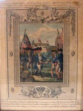
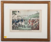 "THE SURRENDER OF CORNWALLIS,"
 COLOR LITHOGRAPH Color lithograph, sheet size: 9 3/4 x 13 3/4 in., framed.
"THE SURRENDER OF CORNWALLIS,"
"THE SURRENDER OF CORNWALLIS," COLOR LITHOGRAPH Color lithograph, sheet size: 9 3/4 x 13 3/4 in., framed. -
 Jan Jansson (Dutch 1588-1664)
 "Somersettensis Comitatus Somerset Shire" and "Suthsexia vernacule Sussex" c. 1650 two hand-colored engraved copperplate maps from the Atlas Noveus with beautiful cartouches ships and compass roses sights 15 1/2 in. x 20 1/4 in. attractively matted and framed alike.
Jan Jansson (Dutch 1588-1664)
Jan Jansson (Dutch 1588-1664) "Somersettensis Comitatus Somerset Shire" and "Suthsexia vernacule Sussex" c. 1650 two hand-colored engraved copperplate maps from the Atlas Noveus with beautiful cartouches ships and compass roses sights 15 1/2 in. x 20 1/4 in. attractively matted and framed alike. -
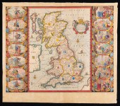 JAN JANSSON MAP OF BRITANNIAJan
 Jansson Map of Britannia , "Britannis Prout Divisa fuit Temporibus Anglo-Saxonum, Praesertim Durante Illorum Heptarchia", Amsterdam, c. 1646, hand-colored engraving, Anglo-Saxon map, with vignettes of the kings of the 5th-7th centuries
JAN JANSSON MAP OF BRITANNIAJan
JAN JANSSON MAP OF BRITANNIAJan Jansson Map of Britannia , "Britannis Prout Divisa fuit Temporibus Anglo-Saxonum, Praesertim Durante Illorum Heptarchia", Amsterdam, c. 1646, hand-colored engraving, Anglo-Saxon map, with vignettes of the kings of the 5th-7th centuries -
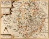
 Three Thomas Kitchin linen backed
 folding County maps of Oxfordshire Glamorganshire Warwickshire and Camarthenshire together with a similar base map of Yorkshire published by T. Jeffery.
Three Thomas Kitchin linen backed
Three Thomas Kitchin linen backed folding County maps of Oxfordshire Glamorganshire Warwickshire and Camarthenshire together with a similar base map of Yorkshire published by T. Jeffery. -
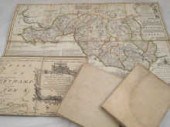
 William Henry Toms (c. 1700-c.
 1755)/Arabia, Petraea et Deferta/engraving, 20cm x 30.5cm and four other maps
William Henry Toms (c. 1700-c.
William Henry Toms (c. 1700-c. 1755)/Arabia, Petraea et Deferta/engraving, 20cm x 30.5cm and four other maps -
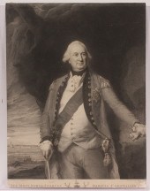 ENGRAVING - 18th century British
 titled 'The Most Noble Charles Marquis Cornwallis' by Benj. Smith after Copley depicting the general whose surrender to Washington at Yorktown ended our Revolutionary War unframed SS: 17 1/4'' x 13 1/4'' condition: clip
ENGRAVING - 18th century British
ENGRAVING - 18th century British titled 'The Most Noble Charles Marquis Cornwallis' by Benj. Smith after Copley depicting the general whose surrender to Washington at Yorktown ended our Revolutionary War unframed SS: 17 1/4'' x 13 1/4'' condition: clip -
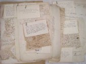 A quantity of mainly 18th century
 historic documents including Treasury matters a letter from Brigadier General Picton from Trinidad 1799 sending specimens of exotic timber a 17th century letter from Lady Cranfield to ''Affrick my maid'' an acknowledgment of receipt of pension by Lady Churchill dated 1787 etc.
A quantity of mainly 18th century
A quantity of mainly 18th century historic documents including Treasury matters a letter from Brigadier General Picton from Trinidad 1799 sending specimens of exotic timber a 17th century letter from Lady Cranfield to ''Affrick my maid'' an acknowledgment of receipt of pension by Lady Churchill dated 1787 etc. -
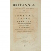 CAMDEN, WILLIAM BRITANNIA: OR A
 CHRONOGRAPHICAL DESCRIPTION of the Flourishing Kingdoms of England, Scotland and Ireland. London: John Stockdale, 1806. 4 volumes, folio, portrait, 106 plates, 54 (of 57) maps and 1 folding table, contemporary half calf gilt(4)
CAMDEN, WILLIAM BRITANNIA: OR A
CAMDEN, WILLIAM BRITANNIA: OR A CHRONOGRAPHICAL DESCRIPTION of the Flourishing Kingdoms of England, Scotland and Ireland. London: John Stockdale, 1806. 4 volumes, folio, portrait, 106 plates, 54 (of 57) maps and 1 folding table, contemporary half calf gilt(4) -
 Christopher Saxton (1540-1610),
 Glamorgan Comitatus Australis Cambrige pars descriptio Ano Dni 1578, the margin with annotation in ink, colour engraved map, 41cm x 56cm
Christopher Saxton (1540-1610),
Christopher Saxton (1540-1610), Glamorgan Comitatus Australis Cambrige pars descriptio Ano Dni 1578, the margin with annotation in ink, colour engraved map, 41cm x 56cm -
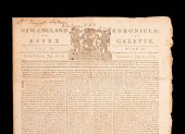 [Historic Newspaper] T. Jefferson
 and J. Dickinson ''A Declaration ... Setting Forth the Causes and Necessity of Taking Up Arms'' as published in The New England Chronicle or The Essex Gazette (Harvard College Cambridge MA) July 27 1775; the entire first and 1/3 of the second page taken up with the manifesto against Great Britain (signed in type ''JOHN HANCOCK'') and also including other news of the day and advertisements (notably some for runaway slaves;) 4pp. folio with vertical fold as issued and light folds into eighths addressed at top ''Mr. Daniel Killam / Wenham'' (1751-1841 later a member of MA legislature) Housed in a blue calf folder with gilt tooling and lettering Estimate $ 10 000-15 000 Some toning and wear especially at edges and along folds.
[Historic Newspaper] T. Jefferson
[Historic Newspaper] T. Jefferson and J. Dickinson ''A Declaration ... Setting Forth the Causes and Necessity of Taking Up Arms'' as published in The New England Chronicle or The Essex Gazette (Harvard College Cambridge MA) July 27 1775; the entire first and 1/3 of the second page taken up with the manifesto against Great Britain (signed in type ''JOHN HANCOCK'') and also including other news of the day and advertisements (notably some for runaway slaves;) 4pp. folio with vertical fold as issued and light folds into eighths addressed at top ''Mr. Daniel Killam / Wenham'' (1751-1841 later a member of MA legislature) Housed in a blue calf folder with gilt tooling and lettering Estimate $ 10 000-15 000 Some toning and wear especially at edges and along folds. -
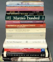 Fourteen books on Holland Norman
 Conquest British history etc.
Fourteen books on Holland Norman
Fourteen books on Holland Norman Conquest British history etc. -
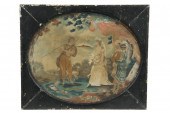 EARLY BRITISH STITCHWORK - 18th c
 English Satin Stitchwork rendering of a Scotsman being welcomed into camp by Britannia in oval format set into black painted oblong panel under glass SS: 16 3/4'' x 20 3/4'' OS: 19 1/4'' x 23'' splitting in painted backg
EARLY BRITISH STITCHWORK - 18th c
EARLY BRITISH STITCHWORK - 18th c English Satin Stitchwork rendering of a Scotsman being welcomed into camp by Britannia in oval format set into black painted oblong panel under glass SS: 16 3/4'' x 20 3/4'' OS: 19 1/4'' x 23'' splitting in painted backg -
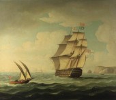 THOMAS BUTTERSWORTH (BRITISH
 1768-1842) HMS HIBERNIA: 120 GUNS OFF THE COAST Oil on canvas: 18 x 21 in. (sight) Framed lower center signed: T Buttersworth verso: The Parker Gallery 2 Albermale Street London Provenance: Estate of Amanda F. Washburn
THOMAS BUTTERSWORTH (BRITISH
THOMAS BUTTERSWORTH (BRITISH 1768-1842) HMS HIBERNIA: 120 GUNS OFF THE COAST Oil on canvas: 18 x 21 in. (sight) Framed lower center signed: T Buttersworth verso: The Parker Gallery 2 Albermale Street London Provenance: Estate of Amanda F. Washburn -
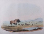 W.C.HARRIS"I. CATOBLEPAS GNOO-THE
 GNOO"William Cornwallis Harris (1807-1848) "I. Catoblepas Gnoo-The Gnoo" hand colored lithograph from "Portraits of the Game and Wild Animals of Southern Africa", framed under glass; measures approximately 23-5/8" x 27-3/4" with a sight image of approximately 12-3/4" x 16-3/4". Major Sir William Cornwallis Harris was an English military engineer, artist and hunter.
W.C.HARRIS"I. CATOBLEPAS GNOO-THE
W.C.HARRIS"I. CATOBLEPAS GNOO-THE GNOO"William Cornwallis Harris (1807-1848) "I. Catoblepas Gnoo-The Gnoo" hand colored lithograph from "Portraits of the Game and Wild Animals of Southern Africa", framed under glass; measures approximately 23-5/8" x 27-3/4" with a sight image of approximately 12-3/4" x 16-3/4". Major Sir William Cornwallis Harris was an English military engineer, artist and hunter. -
 MAP OF THE MOST INHABITED PARTS
 OF NEW ENGLANDBY THOMAS JEFFERYS, DATED 1774. INCLUDES MASS BAY, NH WITH THE COLONIES OF CT & RI. HAND COLORED, EXCELLENT CONDITION BUT SHOWS CREASES FROM FOLDING. SIGHT SIZE 41" X 39 1/2", OVERALL 43 3/4" X 42 1/4". WITH MODERN WOODEN FRAME.
MAP OF THE MOST INHABITED PARTS
MAP OF THE MOST INHABITED PARTS OF NEW ENGLANDBY THOMAS JEFFERYS, DATED 1774. INCLUDES MASS BAY, NH WITH THE COLONIES OF CT & RI. HAND COLORED, EXCELLENT CONDITION BUT SHOWS CREASES FROM FOLDING. SIGHT SIZE 41" X 39 1/2", OVERALL 43 3/4" X 42 1/4". WITH MODERN WOODEN FRAME. -
 Thomas Moule (British
 1785-1851)/Herefordshire, 1841/hand coloured steel engraved map, 26.5cm x 20cm
Thomas Moule (British
Thomas Moule (British 1785-1851)/Herefordshire, 1841/hand coloured steel engraved map, 26.5cm x 20cm -
 WILLIAM HENRY TOMS (ENGLISH,
 1700-1765) MAPWilliam Henry Toms (English, 1700-1765), "This Plan of the Harbour, Town and Forts of Porto Bello (Taken by Edward Vernon Esqr. Vice Admiral of the Blue on the 22 of November 1739, With Six Men of War only", London, 1740, engraved map showing an early battle in the War of Jenkins'Ear, 16 1/4 in. x 22 3/4 in Provenance: Collection of Brooke and Maria Fox, Metairie, LA
WILLIAM HENRY TOMS (ENGLISH,
WILLIAM HENRY TOMS (ENGLISH, 1700-1765) MAPWilliam Henry Toms (English, 1700-1765), "This Plan of the Harbour, Town and Forts of Porto Bello (Taken by Edward Vernon Esqr. Vice Admiral of the Blue on the 22 of November 1739, With Six Men of War only", London, 1740, engraved map showing an early battle in the War of Jenkins'Ear, 16 1/4 in. x 22 3/4 in Provenance: Collection of Brooke and Maria Fox, Metairie, LA -
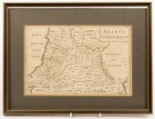
 A map of the Counties of
 Gloucestershire and Monmouth, 1760, dedicated to the Hon. John Thynne, 52cm x 68cm, another of the same and three other maps of Gloucestershire
A map of the Counties of
A map of the Counties of Gloucestershire and Monmouth, 1760, dedicated to the Hon. John Thynne, 52cm x 68cm, another of the same and three other maps of Gloucestershire -
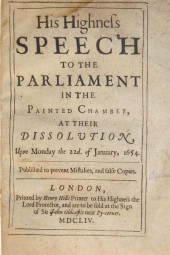 1 vol. English Commonwealth Period
 Imprints: (Cromwell, Oliver.) His Highness Speech to The Parliament in The Painted Chamber, at Their Dissolution,... January, 1654. London: Henry Hills, 1654[5]. Sm. 4to, 19th-Century 1/2 calf & marbled bds.; scuffed, joints & extremities rubbed. Some internal dampstaining. Wing C-7170D. Bound with: (_ _.) A Declaration of His Highness by The Advice of Council,... Reasons... Securing The Peace of The Commonwealth... London: Henry Hills and John Field, 1655. Sm. 4to. Some internal dampstaining. Thomason E-1065[1]. Also bound with: Fiennes, Lord Nathaniel. The Speech of... Made before his Highnesse and both Houses of Parliament:... 27th of January, 1658. 4to. Some dampstaining. All trimmed - a few heads shaved close. Wing F-.
1 vol. English Commonwealth Period
1 vol. English Commonwealth Period Imprints: (Cromwell, Oliver.) His Highness Speech to The Parliament in The Painted Chamber, at Their Dissolution,... January, 1654. London: Henry Hills, 1654[5]. Sm. 4to, 19th-Century 1/2 calf & marbled bds.; scuffed, joints & extremities rubbed. Some internal dampstaining. Wing C-7170D. Bound with: (_ _.) A Declaration of His Highness by The Advice of Council,... Reasons... Securing The Peace of The Commonwealth... London: Henry Hills and John Field, 1655. Sm. 4to. Some internal dampstaining. Thomason E-1065[1]. Also bound with: Fiennes, Lord Nathaniel. The Speech of... Made before his Highnesse and both Houses of Parliament:... 27th of January, 1658. 4to. Some dampstaining. All trimmed - a few heads shaved close. Wing F-. -
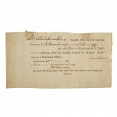 THOMAS HENRY BARCLAY, NY
 LOYALIST, DS Thomas Henry Barclay (1753-1830, Colonial NY attorney, protege of John Jay, served in Loyal American Regiment through the war; led British committees to determine US/Canada border) part-printed certificate, dated June 24, 1799, (presumably at Annapolis, Nova Scotia) that Lt. Col. James Holmes had been exclusively employed as a soldier during the preceding 6 months; signed by Barclay and Holmes; 5 x 9 1/2 in.
THOMAS HENRY BARCLAY, NY
THOMAS HENRY BARCLAY, NY LOYALIST, DS Thomas Henry Barclay (1753-1830, Colonial NY attorney, protege of John Jay, served in Loyal American Regiment through the war; led British committees to determine US/Canada border) part-printed certificate, dated June 24, 1799, (presumably at Annapolis, Nova Scotia) that Lt. Col. James Holmes had been exclusively employed as a soldier during the preceding 6 months; signed by Barclay and Holmes; 5 x 9 1/2 in. -
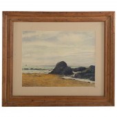 WILLIAM REGINALD WATKINS. "COAST OF
 CORNWALL," WATERCOLOR (American, 1890-1985). "Coast of Cornwall, St. Ives, England," watercolor on paper, signed and dated "W. Reginald Watkins, 1972" lr, sight size: 20 3/4 x 27 1/2 in., framed.
WILLIAM REGINALD WATKINS. "COAST OF
WILLIAM REGINALD WATKINS. "COAST OF CORNWALL," WATERCOLOR (American, 1890-1985). "Coast of Cornwall, St. Ives, England," watercolor on paper, signed and dated "W. Reginald Watkins, 1972" lr, sight size: 20 3/4 x 27 1/2 in., framed. -
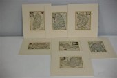 Thomas Conder (fl.
 1775-1801)/Bedfordshire, Berkshire, Cumberland and Westmoreland, Leicester and Rutland, Northumberland, Nottinghamshire, Somersetshire/eight hand coloured engraved maps, various sizes and/two framed maps
Thomas Conder (fl.
Thomas Conder (fl. 1775-1801)/Bedfordshire, Berkshire, Cumberland and Westmoreland, Leicester and Rutland, Northumberland, Nottinghamshire, Somersetshire/eight hand coloured engraved maps, various sizes and/two framed maps -
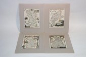 Thomas Moule
 (1785-1851)/Cambridgeshire, Cumberland, Derbyshire and Northumberland/four hand coloured engraved maps, various sizes, unframed
Thomas Moule
Thomas Moule (1785-1851)/Cambridgeshire, Cumberland, Derbyshire and Northumberland/four hand coloured engraved maps, various sizes, unframed -
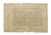 U.S. 1778 privateer license,
 partially printed document headed "Congress. The Delegates of the United States…", licensing William McFadden, Commander of the Sloop Mars, belonging to John Maxwell Nesbitt and Co., "to fit out and set forth the said Sloop in a warlike manner…by Force of Arms, to attack, subdue and take all ships…carrying Soldiers, Arms, Gunpowder, Provisions…to any of the British Armies or Ships of War employed against these United States…Philadelphia, August 4, 1778", signed in brown ink, "Henry Laurens" as President, "Chas Thomson" as Secretary, and "T[imothy] Matlack, Secy of the Council of Pennsa", 8-3/4 x 13 in. Separated into four sections vertically at folds, rejoined with paper tape on verso, folds through "n" of "Laurens" and "Matlack", minor holes, edge chips and losses, marginal dampstains, toning. Descended in the family Lewis Tawes Matlack (later Birkhead), a descendant of Timothy Matlack, the engrosser who hand lettered the Declaration of Independence.
U.S. 1778 privateer license,
U.S. 1778 privateer license, partially printed document headed "Congress. The Delegates of the United States…", licensing William McFadden, Commander of the Sloop Mars, belonging to John Maxwell Nesbitt and Co., "to fit out and set forth the said Sloop in a warlike manner…by Force of Arms, to attack, subdue and take all ships…carrying Soldiers, Arms, Gunpowder, Provisions…to any of the British Armies or Ships of War employed against these United States…Philadelphia, August 4, 1778", signed in brown ink, "Henry Laurens" as President, "Chas Thomson" as Secretary, and "T[imothy] Matlack, Secy of the Council of Pennsa", 8-3/4 x 13 in. Separated into four sections vertically at folds, rejoined with paper tape on verso, folds through "n" of "Laurens" and "Matlack", minor holes, edge chips and losses, marginal dampstains, toning. Descended in the family Lewis Tawes Matlack (later Birkhead), a descendant of Timothy Matlack, the engrosser who hand lettered the Declaration of Independence. -
 Christopher
 Saxton/Brecknoc/Glamorgan/two hand coloured maps, 27cm x 34cm
Christopher
Christopher Saxton/Brecknoc/Glamorgan/two hand coloured maps, 27cm x 34cm -
 Thomas Fuller The Church History of
 Britain; from the Birth of Jesus Christ Until the Year MDCXLVIII 1655 printed for John Williams at the sign of the Crown in St. Paul's Church-yard London folio (13 1/4 in. x 9 in.) bound by Hayday in full calf with gilt tooling and raised bands with copper-plate engraved plates including coat-of-arms Lichfieldensis Cathedral and folding plate of a bird's-eye-view of Canterbury.
Thomas Fuller The Church History of
Thomas Fuller The Church History of Britain; from the Birth of Jesus Christ Until the Year MDCXLVIII 1655 printed for John Williams at the sign of the Crown in St. Paul's Church-yard London folio (13 1/4 in. x 9 in.) bound by Hayday in full calf with gilt tooling and raised bands with copper-plate engraved plates including coat-of-arms Lichfieldensis Cathedral and folding plate of a bird's-eye-view of Canterbury. -
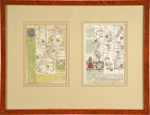 TWO ENGLISH MAPScolored engravings;
 depicting maps of Devonshire and Cornwall; together in one frame; each 7 1/4 x 4 3/4 inches sight; 13 3/4 x 17 1/2 inches frame; Condition:
TWO ENGLISH MAPScolored engravings;
TWO ENGLISH MAPScolored engravings; depicting maps of Devonshire and Cornwall; together in one frame; each 7 1/4 x 4 3/4 inches sight; 13 3/4 x 17 1/2 inches frame; Condition: -
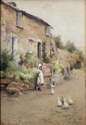 Harry E. James (1870-circa 1920)
 - Watercolour - ''A Roadside Cottage Cornwall'' 10ins x 6.75ins signed and dated '05 in gilt frame and glazed Note : A Royal Institute of Painters in Watercolours label to back of painting gives the title and artist's address
Harry E. James (1870-circa 1920)
Harry E. James (1870-circa 1920) - Watercolour - ''A Roadside Cottage Cornwall'' 10ins x 6.75ins signed and dated '05 in gilt frame and glazed Note : A Royal Institute of Painters in Watercolours label to back of painting gives the title and artist's address -
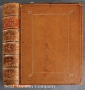
 1 vol. Marshall, John. A History
 of The Colonies Planted by The English on The Continent of North America. Philadelphia: Abraham Small, 1824. First edition thus. 8vo, contemp. sheep; scuffed & occasionally rubbed. Some internal toning & scattered light foxing. Howes M-
1 vol. Marshall, John. A History
1 vol. Marshall, John. A History of The Colonies Planted by The English on The Continent of North America. Philadelphia: Abraham Small, 1824. First edition thus. 8vo, contemp. sheep; scuffed & occasionally rubbed. Some internal toning & scattered light foxing. Howes M-
...many more examples with full details are available to our members - Learn more
Easy & Visual methods to Identify & Appraise Antiques & Collectibles
EASY. FAST. ACCURATE.
Research at its best
We are here to help!
Our research tools include:

Thousands of makers marks for PORCELAIN, POTTERY CHINAWARE, FIGURINES, VASES
see details...

Thousands of marks & hallmarks for SILVER & JEWELRY, PEWTER, PRECIOUS METALS, SILVERPLATE
see details...
