Pricing Guides & Dictionary of Makers Marks for Antiques & Collectibles
A few examples of appraisal values for
FRONTIER FORTS OF PENNSYLVANIA
Search our price guide for your own treasures
-
 Books- Vols. I & II Frontier
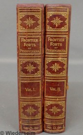
 Forts of Pennsylvania preferred second Edition by Clarence M. Busch State Printer of Pennsylvania 1896.
Books- Vols. I & II Frontier
Books- Vols. I & II Frontier Forts of Pennsylvania preferred second Edition by Clarence M. Busch State Printer of Pennsylvania 1896. -
 [Pennsylvania] About 24 volumes
 on various aspects of the state's history including: Report of the Commission to Locate the Site of the Frontier Forts of Pennsylvania 2 vols.; Butterfield History of the Girtys; O. McKnight Simon Girty The White Savage; Kuhns German and Swiss Settlements of Pennsylvania; and Gibbons Pennsylvania Dutch and Other Essays Estimate $ 150-250
[Pennsylvania] About 24 volumes
[Pennsylvania] About 24 volumes on various aspects of the state's history including: Report of the Commission to Locate the Site of the Frontier Forts of Pennsylvania 2 vols.; Butterfield History of the Girtys; O. McKnight Simon Girty The White Savage; Kuhns German and Swiss Settlements of Pennsylvania; and Gibbons Pennsylvania Dutch and Other Essays Estimate $ 150-250 -
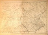
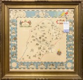
 1 piece. Hand-Colored
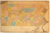
 Manuscript Map. "Pennsylvania." Ca 1831. Pen & ink & watercolor on paper. 15 1/2 x 22 3/4 inches (393 x 577 mm). Generally bright & clean - minor wear & discoloration along edges, small abrasion on northeast Philadelphia. In 19th-century frame. Possibly a prototype for the Pennsylvania map published by Anthony Finley after 1831. Juniata County, established in 1831, appears here but not on Finley's 1831 Pennsylvania map.
1 piece. Hand-Colored
1 piece. Hand-Colored Manuscript Map. "Pennsylvania." Ca 1831. Pen & ink & watercolor on paper. 15 1/2 x 22 3/4 inches (393 x 577 mm). Generally bright & clean - minor wear & discoloration along edges, small abrasion on northeast Philadelphia. In 19th-century frame. Possibly a prototype for the Pennsylvania map published by Anthony Finley after 1831. Juniata County, established in 1831, appears here but not on Finley's 1831 Pennsylvania map. -
 A Pennsylvania land grant on
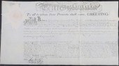
 parchment dated 7-16-1806, granting a property in Venango County named "Fortland" to Alexander Baring & others, and signed as Pennsylvania governor by Founding Father and Signer of the Declaration of Independence Thomas McKean (1734-1817). McKean was the delegate to the Second Continental Congress whose note brought his fellow Delaware delegate Caesar Rodney riding back to the Congress, to break the deadlock and swing Delaware's vote for American independence. This document was also signed by the first Deputy Secretary of the Commonwealth, James Trimble (1755-1837), and by Timothy Matlack (1736-1829), another of the Founding Fathers who wrote out the formal copy of the Declaration of Independence.
A Pennsylvania land grant on
A Pennsylvania land grant on parchment dated 7-16-1806, granting a property in Venango County named "Fortland" to Alexander Baring & others, and signed as Pennsylvania governor by Founding Father and Signer of the Declaration of Independence Thomas McKean (1734-1817). McKean was the delegate to the Second Continental Congress whose note brought his fellow Delaware delegate Caesar Rodney riding back to the Congress, to break the deadlock and swing Delaware's vote for American independence. This document was also signed by the first Deputy Secretary of the Commonwealth, James Trimble (1755-1837), and by Timothy Matlack (1736-1829), another of the Founding Fathers who wrote out the formal copy of the Declaration of Independence. -
 [Western Maryland] Brantz Mayer
 (1809-'79) original pencil sketch ''Ruins of Fort Frederick ... July 1858;'' framed identified and signed l.l.; matted in an oval aperture 7 3/8 X 14 in. visible; showing the massive walls of the fort constructed during the French and Indian War shortly after Mayer's visit to be occupied by a Union garrison against Confederates on the opposite bank of the Potomac Estimate $ 150-250 Paper is evenly toned.
[Western Maryland] Brantz Mayer
[Western Maryland] Brantz Mayer (1809-'79) original pencil sketch ''Ruins of Fort Frederick ... July 1858;'' framed identified and signed l.l.; matted in an oval aperture 7 3/8 X 14 in. visible; showing the massive walls of the fort constructed during the French and Indian War shortly after Mayer's visit to be occupied by a Union garrison against Confederates on the opposite bank of the Potomac Estimate $ 150-250 Paper is evenly toned. -
 Pennsylvania Federal ch
Pennsylvania Federal ch
Pennsylvania Federal ch -
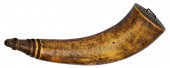 French and Indian War Map
 Horn--Forbes Trail to Fort Pitt 14'' length triple raised ring with smooth spout engraved with forts and Royal Coat of Arms. This well-travelled map horn shows every fort from New York to Fort Pitt at the Three Rivers. Wood base and iron carrying staple. While the owner is unknown the horn has a historic connection to the Forbes Trail that solidified British dominance in the Ohio Territory following the ejection of the French. This extraordinary engraved map horn depicts the sequential forts and way points on the trail from Colonial New York to remote Fort Pitt (Pittsburgh) at the strategic Forks of the Ohio. The track departing from the frontier post of Carlisle is the path of the famed ''Forbes Road'' built by an army of 5 000 British regulars and Colonial militia under the direction of General John Forbes (1707-1759). Following the death of General Braddock during the ill-fated expedition against Ft. Duquesne in 1755 Forbes took command of British forces and commenced building a more direct road through 200 miles of trackless wilderness to attack the French at the strategic Forks. Hewn by hand from the primeval forest the Forbes Trail was 20 foot wide and traversed the Allegheny Mountains with fortified supply posts (Raystown and Ligonier) at supporting intervals. The rough road was sufficient to support wagons and artillery and was completed in November 1758. The British advance column was attacked and bloodily repulsed on September 15 1758 causing Forbes to immediately halt operations against Fort Dusquesne. Later in the fall the French at Fort Frontenac were forced to surrender leaving Fort Dusquesne with a much reduced garrison as their fickled Indian allies melted away. The sudden appearance of a large force of Redcoats emerging from the forest gloom so intimidated the few remaining French regulars that Fort Duquesne was burned to the ground and quickly abandoned. Forbes took control of the illusive prize on November 25 1758 and ordered the post rebuilt naming it Fort Pitt in honor of his mentor William Pitt the Elder British Secretary of State. Gravely ill through most of the grueling march Forbes soon returned to Philadelphia where he died on March 11 1759. Tracing Forbes' route the principal points are as follows: Fort Edward Fort Stanwix Crown Point Fort Henry Fort Carillon R. Blockhouse Mcniel H.A. Moon Albany Philadelphia Lancaster Shapsburg Carlisle York Loundon and Bedford. The horn was likely carved and carried shortly after the construction of the new fort by a participant of the Forbes expedition as the names and locations generally correspond to the names known in 1758 culminating of course with Ft Pitt. Today parts of the Pennsylvania Turnpike and US Route 30 parallel the old Forbes Trail with key road markers westbound in Bedford and Westmorland County. As well as commemorating the Forbes Road and the ultimate capture of Ft. Duquesne it is appealing to think of this historic horn in practical terms as a sort of portable road map anticipating the thrust of future frontier travel. Of course the major significance of the Forbes Road in the decades following the French & Indian War was as a major land route into the heart of the prime Ohio country connecting Philadelphia and Pittsburgh. Condition: Very good. Nice even patina overall.
French and Indian War Map
French and Indian War Map Horn--Forbes Trail to Fort Pitt 14'' length triple raised ring with smooth spout engraved with forts and Royal Coat of Arms. This well-travelled map horn shows every fort from New York to Fort Pitt at the Three Rivers. Wood base and iron carrying staple. While the owner is unknown the horn has a historic connection to the Forbes Trail that solidified British dominance in the Ohio Territory following the ejection of the French. This extraordinary engraved map horn depicts the sequential forts and way points on the trail from Colonial New York to remote Fort Pitt (Pittsburgh) at the strategic Forks of the Ohio. The track departing from the frontier post of Carlisle is the path of the famed ''Forbes Road'' built by an army of 5 000 British regulars and Colonial militia under the direction of General John Forbes (1707-1759). Following the death of General Braddock during the ill-fated expedition against Ft. Duquesne in 1755 Forbes took command of British forces and commenced building a more direct road through 200 miles of trackless wilderness to attack the French at the strategic Forks. Hewn by hand from the primeval forest the Forbes Trail was 20 foot wide and traversed the Allegheny Mountains with fortified supply posts (Raystown and Ligonier) at supporting intervals. The rough road was sufficient to support wagons and artillery and was completed in November 1758. The British advance column was attacked and bloodily repulsed on September 15 1758 causing Forbes to immediately halt operations against Fort Dusquesne. Later in the fall the French at Fort Frontenac were forced to surrender leaving Fort Dusquesne with a much reduced garrison as their fickled Indian allies melted away. The sudden appearance of a large force of Redcoats emerging from the forest gloom so intimidated the few remaining French regulars that Fort Duquesne was burned to the ground and quickly abandoned. Forbes took control of the illusive prize on November 25 1758 and ordered the post rebuilt naming it Fort Pitt in honor of his mentor William Pitt the Elder British Secretary of State. Gravely ill through most of the grueling march Forbes soon returned to Philadelphia where he died on March 11 1759. Tracing Forbes' route the principal points are as follows: Fort Edward Fort Stanwix Crown Point Fort Henry Fort Carillon R. Blockhouse Mcniel H.A. Moon Albany Philadelphia Lancaster Shapsburg Carlisle York Loundon and Bedford. The horn was likely carved and carried shortly after the construction of the new fort by a participant of the Forbes expedition as the names and locations generally correspond to the names known in 1758 culminating of course with Ft Pitt. Today parts of the Pennsylvania Turnpike and US Route 30 parallel the old Forbes Trail with key road markers westbound in Bedford and Westmorland County. As well as commemorating the Forbes Road and the ultimate capture of Ft. Duquesne it is appealing to think of this historic horn in practical terms as a sort of portable road map anticipating the thrust of future frontier travel. Of course the major significance of the Forbes Road in the decades following the French & Indian War was as a major land route into the heart of the prime Ohio country connecting Philadelphia and Pittsburgh. Condition: Very good. Nice even patina overall. -
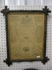
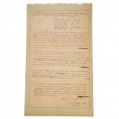
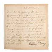 FRENCH & INDIAN WAR DS,
 PENNSYLVANIA, 1758 Original signed order of Deputy Governor William Denny (1709-'65, royal governor of Pennsylvania, 1756-'59) May 8, 1758, requiring Capt. Garraway's company of militia to gather at Bethlehem and all the other forces east of the Susquehanna to prepare to march to Carlisle "on the first Notice," and announcing the promotion of Capt. Joseph Shippen to Brigade Major. Shippen, 1732-1810, and his soldiers would play a prominent role in Forbes' Campaign, which culminated in the capture of Fort Duquesne on Nov. 25, 1758; 1 p. 4to, laid down on a heavy sheet of paper.
FRENCH & INDIAN WAR DS,
FRENCH & INDIAN WAR DS, PENNSYLVANIA, 1758 Original signed order of Deputy Governor William Denny (1709-'65, royal governor of Pennsylvania, 1756-'59) May 8, 1758, requiring Capt. Garraway's company of militia to gather at Bethlehem and all the other forces east of the Susquehanna to prepare to march to Carlisle "on the first Notice," and announcing the promotion of Capt. Joseph Shippen to Brigade Major. Shippen, 1732-1810, and his soldiers would play a prominent role in Forbes' Campaign, which culminated in the capture of Fort Duquesne on Nov. 25, 1758; 1 p. 4to, laid down on a heavy sheet of paper. -
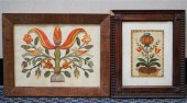
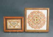 TWO PENNSYLVANIA DUTCH
 FRAKTERSTwo Pennsylvania Dutch Frakters
TWO PENNSYLVANIA DUTCH
TWO PENNSYLVANIA DUTCH FRAKTERSTwo Pennsylvania Dutch Frakters -
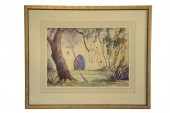 WATERCOLOR - Fortress by Rupert
 Lovejoy (Pennsylvania 1885-1975) matted in gold painted frame SS: 14 1/2'' x 20'' OS: 25'' x 31'' good condition.
WATERCOLOR - Fortress by Rupert
WATERCOLOR - Fortress by Rupert Lovejoy (Pennsylvania 1885-1975) matted in gold painted frame SS: 14 1/2'' x 20'' OS: 25'' x 31'' good condition. -
 1 piece. Engraved Map with
 Outline Color. Scull, W., after. "A Map of Pennsylvania Exhibiting not Only the Improved Parts of The Province, but also Its Extensive Frontiers..." N.p. [London? or Paris?], [ca. 1775]. 29 x 39 inches (739 x 990 mm). 2 of 3 sheets only, lacking the Western portion. Some darkening to margins. Mounted to bd. See Phillips, A List of Maps of America, pp. 674 &
1 piece. Engraved Map with
1 piece. Engraved Map with Outline Color. Scull, W., after. "A Map of Pennsylvania Exhibiting not Only the Improved Parts of The Province, but also Its Extensive Frontiers..." N.p. [London? or Paris?], [ca. 1775]. 29 x 39 inches (739 x 990 mm). 2 of 3 sheets only, lacking the Western portion. Some darkening to margins. Mounted to bd. See Phillips, A List of Maps of America, pp. 674 & -
 1840 Pennsylvania Fraktur Berks
 County in carved twig frame
1840 Pennsylvania Fraktur Berks
1840 Pennsylvania Fraktur Berks County in carved twig frame -
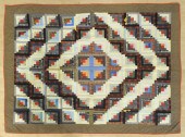
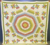 Colorful Pennsylvania quilt in
 the Lone Star pattern 1860. 71''x71''
Colorful Pennsylvania quilt in
Colorful Pennsylvania quilt in the Lone Star pattern 1860. 71''x71'' -
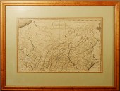 Maple framed and matted early map
 of Pennsylvania by Samuel Lewis from 1795 Cary American Atlas (Phila.). 11.5"x18"
Maple framed and matted early map
Maple framed and matted early map of Pennsylvania by Samuel Lewis from 1795 Cary American Atlas (Phila.). 11.5"x18" -
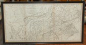 MAP OF PENNSYLVANIA, SAYER AND
 BENNETT, 1775 "A Map of Pennsylvania, Exhibiting not only the Improved Parts of that Province, but also its Extensive Frontiers," largely drawing on W. Scull's map of 1770; engraving with light outlining, printed on three large sheets joined together, 27 1/2 in. H., plus margins, 53 in. W. visible; framed.
MAP OF PENNSYLVANIA, SAYER AND
MAP OF PENNSYLVANIA, SAYER AND BENNETT, 1775 "A Map of Pennsylvania, Exhibiting not only the Improved Parts of that Province, but also its Extensive Frontiers," largely drawing on W. Scull's map of 1770; engraving with light outlining, printed on three large sheets joined together, 27 1/2 in. H., plus margins, 53 in. W. visible; framed. -
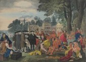 Benj. West/H.R. Robinsen, New
 York "William Penn's Treaty with the Indians when he founded the Province of Pennsylvania 1681". Hand colored lithograph, the sight size approx. 18-1/2" x 24-1/4", French matted and framed under glass overall approx. 29-1/2" x 34-1/2".
Benj. West/H.R. Robinsen, New
Benj. West/H.R. Robinsen, New York "William Penn's Treaty with the Indians when he founded the Province of Pennsylvania 1681". Hand colored lithograph, the sight size approx. 18-1/2" x 24-1/4", French matted and framed under glass overall approx. 29-1/2" x 34-1/2". -
 TWO PENNSYLVANIA DUTCH
 FRAKTURSTwo Pennsylvania Dutch Frakturs
TWO PENNSYLVANIA DUTCH
TWO PENNSYLVANIA DUTCH FRAKTURSTwo Pennsylvania Dutch Frakturs -
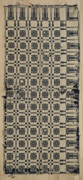 Three Pennsylvania coverlets ca.
 1840. ?
Three Pennsylvania coverlets ca.
Three Pennsylvania coverlets ca. 1840. ? -
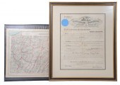 A framed 1865 corporation charter
 document for The Farmers Oil Company of Venango County, bearing a signature at upper left of Pennsylvania governor Andrew G. Curtin. The Pennsylvania oil boom of the 1850s and 1860s was the beginning of the modern American oil industry. Together with a large 1883 map of Pennsylvania by Frank A. Gray, 20" by 30".
A framed 1865 corporation charter
A framed 1865 corporation charter document for The Farmers Oil Company of Venango County, bearing a signature at upper left of Pennsylvania governor Andrew G. Curtin. The Pennsylvania oil boom of the 1850s and 1860s was the beginning of the modern American oil industry. Together with a large 1883 map of Pennsylvania by Frank A. Gray, 20" by 30". -
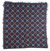
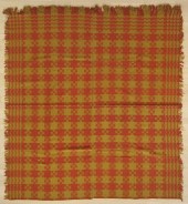
 Pennsylvania jacquard coverlet with
 eagle borders inscribed Martin. B Breneman Washingto Township York Count PA. 1844. John C Dosch ... ?
Pennsylvania jacquard coverlet with
Pennsylvania jacquard coverlet with eagle borders inscribed Martin. B Breneman Washingto Township York Count PA. 1844. John C Dosch ... ? -
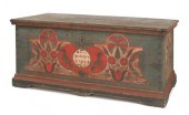 Pennsylvania painted dower chest
 dated 1780 the front with a central red heart with oval inset and two birds flanked by stylized... ?
Pennsylvania painted dower chest
Pennsylvania painted dower chest dated 1780 the front with a central red heart with oval inset and two birds flanked by stylized... ? -
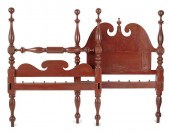 Pennsylvania painted tall post
 bed ca. 1830 with carved boldly turned posts with philphlots and a broken arched paneled headboard ... ?
Pennsylvania painted tall post
Pennsylvania painted tall post bed ca. 1830 with carved boldly turned posts with philphlots and a broken arched paneled headboard ... ? -
 Pennsylvania jacquard coverlet
 ca. 1840 with eagle corners 78" x 89". ?
Pennsylvania jacquard coverlet
Pennsylvania jacquard coverlet ca. 1840 with eagle corners 78" x 89". ? -
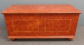 Lancaster County, Pennsylvania,
 flame grain painted blanket chest, circa 1830, 23"h x 48"l
Lancaster County, Pennsylvania,
Lancaster County, Pennsylvania, flame grain painted blanket chest, circa 1830, 23"h x 48"l -
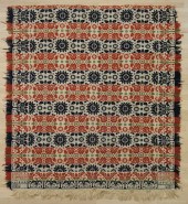
 Two Pennsylvania coverlets ca.
 1840. ?
Two Pennsylvania coverlets ca.
Two Pennsylvania coverlets ca. 1840. ? -
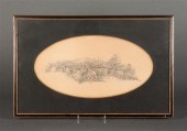
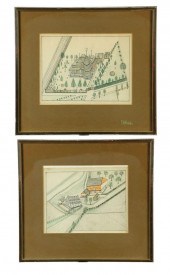 PICTURES OF TWO PENNSYLVANIA
 HOMESTEADS. Ca. 1915 colored pencil on paper unsigned. Arial views of a farm and a home with a turret both from Lancaster County and by the same artist. In matching frames 13 1/2''h. 14 3/4''w.
PICTURES OF TWO PENNSYLVANIA
PICTURES OF TWO PENNSYLVANIA HOMESTEADS. Ca. 1915 colored pencil on paper unsigned. Arial views of a farm and a home with a turret both from Lancaster County and by the same artist. In matching frames 13 1/2''h. 14 3/4''w. -
 Three Pennsylvania coverlets ca.
 1840. ?
Three Pennsylvania coverlets ca.
Three Pennsylvania coverlets ca. 1840. ? -
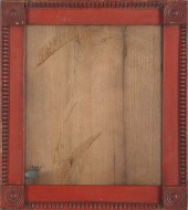 Pennsylvania carved and painted
 poplar frame 19th c. with reeded quarter columns and blocked corners retaining an old red surface ... ?
Pennsylvania carved and painted
Pennsylvania carved and painted poplar frame 19th c. with reeded quarter columns and blocked corners retaining an old red surface ... ? -
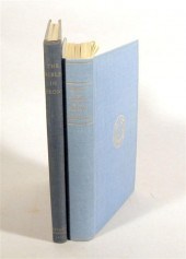 2 vols. Pennsylvania Forges,
 Furnaces and Ironwork: Pennsylvania Society of The Colonial Dames of America. Forges and Furnaces in The Province of Pennsylvania. Philadelphia, 1914. 1st ed. 8vo, orig. blue cloth, gilt, t.e.g., other edges untrimmed; light wear. Plates. * Mercer, Henry C. The Bible in Iron. Doylestown: Bucks County Historical Society, 1941. 2nd ed. 4to, orig. blue cloth, gilt; slightly dusty, corners bumped. Photo illus. Minor foxing on title page. Descriptions provided in both printed and on-line catalogue formats do not include condition reports. The absence of a condition statement does not imply that the lot is in perfect condition or completely free from wear and tear, imperfections or the effects of aging. Interested bidders are strongly encouraged to request a condition report on any lots upon which they intend to bid, prior to placing a bid. All transactions are governed by Freeman''s Conditions of Sale.
2 vols. Pennsylvania Forges,
2 vols. Pennsylvania Forges, Furnaces and Ironwork: Pennsylvania Society of The Colonial Dames of America. Forges and Furnaces in The Province of Pennsylvania. Philadelphia, 1914. 1st ed. 8vo, orig. blue cloth, gilt, t.e.g., other edges untrimmed; light wear. Plates. * Mercer, Henry C. The Bible in Iron. Doylestown: Bucks County Historical Society, 1941. 2nd ed. 4to, orig. blue cloth, gilt; slightly dusty, corners bumped. Photo illus. Minor foxing on title page. Descriptions provided in both printed and on-line catalogue formats do not include condition reports. The absence of a condition statement does not imply that the lot is in perfect condition or completely free from wear and tear, imperfections or the effects of aging. Interested bidders are strongly encouraged to request a condition report on any lots upon which they intend to bid, prior to placing a bid. All transactions are governed by Freeman''s Conditions of Sale. -
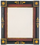 Pennsylvania carved pine frame 19th
 c. with a red and yellow interior surrounded by black half columns and block corners with a... ?
Pennsylvania carved pine frame 19th
Pennsylvania carved pine frame 19th c. with a red and yellow interior surrounded by black half columns and block corners with a... ? -
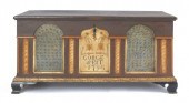 Pennsylvania painted dower chest
 inscribed Gorge Weit 1794 with architectural panels and ogee bracket feet 25" h. 48" w. 22... ?
Pennsylvania painted dower chest
Pennsylvania painted dower chest inscribed Gorge Weit 1794 with architectural panels and ogee bracket feet 25" h. 48" w. 22... ? -
 A framed map of historical
 Chester County, Pennsylvania by Andrew Wyeth.
A framed map of historical
A framed map of historical Chester County, Pennsylvania by Andrew Wyeth. -
 Four Pennsylvania pieced quilts
 early/mid 20th c. ?
Four Pennsylvania pieced quilts
Four Pennsylvania pieced quilts early/mid 20th c. ? -
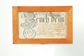 FRAKTUR. Pennsylvania 18th
 century ink on paper. Vorschrift in a style similar to the Conestoga Township Artist. Fine penmanship most likely of a bible verse to be used as a teaching device in the schoolroom. Some imperfections. In a frame 10''h. 15 3/4''w. Sight size is 7 x 13 inches Several small stains pencil marks on borders and one fold line.
FRAKTUR. Pennsylvania 18th
FRAKTUR. Pennsylvania 18th century ink on paper. Vorschrift in a style similar to the Conestoga Township Artist. Fine penmanship most likely of a bible verse to be used as a teaching device in the schoolroom. Some imperfections. In a frame 10''h. 15 3/4''w. Sight size is 7 x 13 inches Several small stains pencil marks on borders and one fold line. -
 COURT MARTIAL DOCUMENT; FORBES'S
 EXPEDITION, 1758 Paul Jackson (1729-1767, Captain in PA Militia, formerly Professor of Greek and Latin and Clerk of Trustees at University of Pennsylvania, later a physician and judge in Chester Co.) Original ADS, comprising a record of the proceedings of a court martial ordered by Col. Hugh Mercer at Ft. Bedford, near Raystown (now Bedford, PA), Sept 8, 1758; 1 p. folio. Three of the four cases involved soldiers under command of Capt James Robertson, 42nd Regt. of Foot, who, upon return from road-building at Laurel Hill, had fired their weapons against orders. One was acquitted, but the other two received 300 and 500 lashes with cat o' nine tails for the infraction. The fourth case involved a wagoneer who defied Major Joseph Shippen's authority and was sentenced to 300 lashes.
COURT MARTIAL DOCUMENT; FORBES'S
COURT MARTIAL DOCUMENT; FORBES'S EXPEDITION, 1758 Paul Jackson (1729-1767, Captain in PA Militia, formerly Professor of Greek and Latin and Clerk of Trustees at University of Pennsylvania, later a physician and judge in Chester Co.) Original ADS, comprising a record of the proceedings of a court martial ordered by Col. Hugh Mercer at Ft. Bedford, near Raystown (now Bedford, PA), Sept 8, 1758; 1 p. folio. Three of the four cases involved soldiers under command of Capt James Robertson, 42nd Regt. of Foot, who, upon return from road-building at Laurel Hill, had fired their weapons against orders. One was acquitted, but the other two received 300 and 500 lashes with cat o' nine tails for the infraction. The fourth case involved a wagoneer who defied Major Joseph Shippen's authority and was sentenced to 300 lashes. -
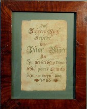 Pennsylvania German fraktur dated
 1786 mounted in a flame grain painted frame. 13"x18"
Pennsylvania German fraktur dated
Pennsylvania German fraktur dated 1786 mounted in a flame grain painted frame. 13"x18"
...many more examples with full details are available to our members - Learn more
Easy & Visual methods to Identify & Appraise Antiques & Collectibles
EASY. FAST. ACCURATE.
Research at its best
We are here to help!
Our research tools include:

Thousands of makers marks for PORCELAIN, POTTERY CHINAWARE, FIGURINES, VASES
see details...

Thousands of marks & hallmarks for SILVER & JEWELRY, PEWTER, PRECIOUS METALS, SILVERPLATE
see details...
