Pricing Guides & Dictionary of Makers Marks for Antiques & Collectibles
A few examples of appraisal values for
HOME ATLANTIC
Search our price guide for your own treasures
-
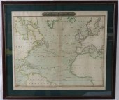
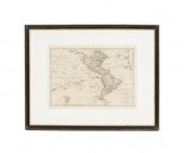
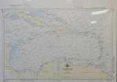
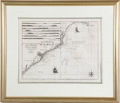
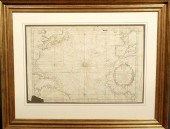 French map of the Atlantic Ocean by
 Bellin c.1760 framed and matted. As found. 13"x20"
French map of the Atlantic Ocean by
French map of the Atlantic Ocean by Bellin c.1760 framed and matted. As found. 13"x20" -
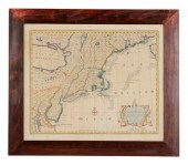
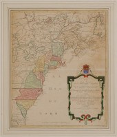 Map of Colonial America Carte
 Nouvelle de L'Amerique Angloise… by Matthieu Albert Lotter, Augsburg, circa 1776, from Lotter's Atlas Geographique, showing the Atlantic seaboard from Canada to Florida with the 13 original colonies filled in and outlined in hand color, on wove paper, 23-3/4 x 19-1/4 in. (sight), modern wood frame,
Map of Colonial America Carte
Map of Colonial America Carte Nouvelle de L'Amerique Angloise… by Matthieu Albert Lotter, Augsburg, circa 1776, from Lotter's Atlas Geographique, showing the Atlantic seaboard from Canada to Florida with the 13 original colonies filled in and outlined in hand color, on wove paper, 23-3/4 x 19-1/4 in. (sight), modern wood frame, -
 Hermann Herzog (German/American,
 1832-1932) "Atlantic City", pencil on paper, sight 4" x 6", titled lower left, retains gallery label en verso "Chapellier Galleries, Inc., NY". Glazed, matted and framed. Provenance: The estates of David and Eula Wintermann.
Hermann Herzog (German/American,
Hermann Herzog (German/American, 1832-1932) "Atlantic City", pencil on paper, sight 4" x 6", titled lower left, retains gallery label en verso "Chapellier Galleries, Inc., NY". Glazed, matted and framed. Provenance: The estates of David and Eula Wintermann. -
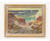 William Brandford Green (1871-1945,
 NY/CT), oil on canvas titled "Atlantic Coast", dated 1932. 17" x 22" ss / 21.5" x 27" oa Condition: Cracking to paint.
William Brandford Green (1871-1945,
William Brandford Green (1871-1945, NY/CT), oil on canvas titled "Atlantic Coast", dated 1932. 17" x 22" ss / 21.5" x 27" oa Condition: Cracking to paint. -
 LATE. 18TH C. PARTIAL MAP OF THE
 ATLANTIC COAST Antonio Zatta (Italian 1757-1797), "Parte Orientale della Florida, della Georgia, e Carolina Meridionale" late 18th century, etching on paper depicting the Atlantic coast during the American Civil War, produced for an atlas, framed. Approximate dimensions: image h. 12.375", w. 16.625"; frame h. 18", w. 23", d. 1.25".
LATE. 18TH C. PARTIAL MAP OF THE
LATE. 18TH C. PARTIAL MAP OF THE ATLANTIC COAST Antonio Zatta (Italian 1757-1797), "Parte Orientale della Florida, della Georgia, e Carolina Meridionale" late 18th century, etching on paper depicting the Atlantic coast during the American Civil War, produced for an atlas, framed. Approximate dimensions: image h. 12.375", w. 16.625"; frame h. 18", w. 23", d. 1.25". -
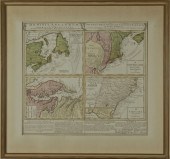
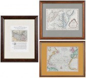 THREE FRAMED MAPS, ATLANTIC,
 CHESAPEAKE, AND THE AMERIC...engravings on laid paper with hand color, comprising: Jacques Nicolas Bellin, Carte De La Baye Chesapeack et pays Voisins... , Paris, circa 1757, sight 7-1/2 x 11-1/4 in.; Thomas Bowen, A New & Accurate Chart of the Western or Atlantic Ocean Drawn from Surveys and most approved Maps & Charts , London, 1788, sight 8 x 10 in.; Descrittione dell'America, o dell'India Occidentale. America , 1598, sight 11-1/4 x 7-3/4 in.; wood frames, 19-7/8 x 16-1/4 in. Condition: scattered light staining, toning, creasing, not examined out of frames; frames with light wear and abrasions
THREE FRAMED MAPS, ATLANTIC,
THREE FRAMED MAPS, ATLANTIC, CHESAPEAKE, AND THE AMERIC...engravings on laid paper with hand color, comprising: Jacques Nicolas Bellin, Carte De La Baye Chesapeack et pays Voisins... , Paris, circa 1757, sight 7-1/2 x 11-1/4 in.; Thomas Bowen, A New & Accurate Chart of the Western or Atlantic Ocean Drawn from Surveys and most approved Maps & Charts , London, 1788, sight 8 x 10 in.; Descrittione dell'America, o dell'India Occidentale. America , 1598, sight 11-1/4 x 7-3/4 in.; wood frames, 19-7/8 x 16-1/4 in. Condition: scattered light staining, toning, creasing, not examined out of frames; frames with light wear and abrasions -
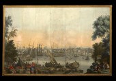 "Boston Harbor", a Set of Jean
 Zuber et Cie., Rixheim, Alsace, Vues d'Amerique du Nord Wallpaper Panels, ca. 1940, overall 88" x 137-1/2", mounted on plywood with a narrow giltwood frame.
"Boston Harbor", a Set of Jean
"Boston Harbor", a Set of Jean Zuber et Cie., Rixheim, Alsace, Vues d'Amerique du Nord Wallpaper Panels, ca. 1940, overall 88" x 137-1/2", mounted on plywood with a narrow giltwood frame. -
 18th century map of the Americas,
 Plate 3 of "Ocean Atlantique et Mers Adjacentes en Quatre Feuilles…" by Robert Sayer, showing southeastern North America, the Gulf of Mexico, the Caribbean Islands, and northern South America, published in Pilote Americain by George Louis Le Rouge, France, 1778, copper engraving on laid paper with watermarks, page 21 x 28-1/2 in.; modern wood frame. Archival tape, earlier paper hinges still attached, toning, foxing, fading, soiling, stains, pest damage, reinforced center crease, tears and losses in margins, numerous fills and repaired tears, "56" in ink verso (probably period); frame with abrasions. Deaccessioned from MESDA and Old Salem to benefit the Acquisition Fund.
18th century map of the Americas,
18th century map of the Americas, Plate 3 of "Ocean Atlantique et Mers Adjacentes en Quatre Feuilles…" by Robert Sayer, showing southeastern North America, the Gulf of Mexico, the Caribbean Islands, and northern South America, published in Pilote Americain by George Louis Le Rouge, France, 1778, copper engraving on laid paper with watermarks, page 21 x 28-1/2 in.; modern wood frame. Archival tape, earlier paper hinges still attached, toning, foxing, fading, soiling, stains, pest damage, reinforced center crease, tears and losses in margins, numerous fills and repaired tears, "56" in ink verso (probably period); frame with abrasions. Deaccessioned from MESDA and Old Salem to benefit the Acquisition Fund. -
 19TH CENTURY MANUSCRIPT MAP OF
 THE ATLANTICAmerican, probably Civil War era, hand drawn map on wove paper with J. Whatman's watermark, depicting the coasts of North and Upper South America, Spain, and Africa, with voyage notes and dates, unframed, sheet 8-1/2 x 15-5/8 in. Note: Inscribed verso "Civil War Map/probably a voyage by a Union gunboat beginning at Portsmouth, N.H. July 14 and ending on Florida coast Sept. 12". Provenance: Private Collection Condition: some creasing and small tears to edges, toning and light staining throughout, reinforced along fold lines verso
19TH CENTURY MANUSCRIPT MAP OF
19TH CENTURY MANUSCRIPT MAP OF THE ATLANTICAmerican, probably Civil War era, hand drawn map on wove paper with J. Whatman's watermark, depicting the coasts of North and Upper South America, Spain, and Africa, with voyage notes and dates, unframed, sheet 8-1/2 x 15-5/8 in. Note: Inscribed verso "Civil War Map/probably a voyage by a Union gunboat beginning at Portsmouth, N.H. July 14 and ending on Florida coast Sept. 12". Provenance: Private Collection Condition: some creasing and small tears to edges, toning and light staining throughout, reinforced along fold lines verso -
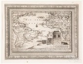
 19TH CENTURY COLORED CHART OF THE
 NORTH ATLANTICOCEAN, WITH TRACKS OF SHIPPING TO THE WEST INDIES AND NORTH AMERICA, AS WELL AS BORDERING LAND MASSES. SHOWS MINOR STAINING AND FOXING, FOLD IN CENTER, AND MINOR LOSS TO THE BOTTOM BORDER. ENGRAVED BY JOHN MOFFAT, EDINBURGH. SIGHT SIZE 21 1/2" X 25 1/2" , OVERALL 27 1/4" X 31".
19TH CENTURY COLORED CHART OF THE
19TH CENTURY COLORED CHART OF THE NORTH ATLANTICOCEAN, WITH TRACKS OF SHIPPING TO THE WEST INDIES AND NORTH AMERICA, AS WELL AS BORDERING LAND MASSES. SHOWS MINOR STAINING AND FOXING, FOLD IN CENTER, AND MINOR LOSS TO THE BOTTOM BORDER. ENGRAVED BY JOHN MOFFAT, EDINBURGH. SIGHT SIZE 21 1/2" X 25 1/2" , OVERALL 27 1/4" X 31". -
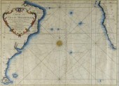 SEA FARING MAP, ATLANTIC OCEAN,
 1746A map (folds), "Carte De L’Océan Méridional", by M. Bellin, Marine Engineer. A very interesting sea faring map delineating the major navigational routes between southern Africa and South America. Hand coloured with a decorative central compass rose and dated 1746. Framed. 13 3/8" x 17 3/4".
SEA FARING MAP, ATLANTIC OCEAN,
SEA FARING MAP, ATLANTIC OCEAN, 1746A map (folds), "Carte De L’Océan Méridional", by M. Bellin, Marine Engineer. A very interesting sea faring map delineating the major navigational routes between southern Africa and South America. Hand coloured with a decorative central compass rose and dated 1746. Framed. 13 3/8" x 17 3/4". -
 Middle Atlantic, New England Map
 London, England, 18th century, \"A New and Accurate Map of New Jersey, Pensilvania [sic], New York and New England, with the adjacent Countri
Middle Atlantic, New England Map
Middle Atlantic, New England Map London, England, 18th century, \"A New and Accurate Map of New Jersey, Pensilvania [sic], New York and New England, with the adjacent Countri -
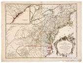 ROBERT DE VAUGONDY MID-ATLANTIC
 AMERICA MAPRobert de Vaugondy Mid-Atlantic region of America map, ca. 1755 , inscribed Partie de L'Amerique Septentrionale qui comprend Le Cours de L'Ohio, la Nlle. Angleterre, La Nlle York, Le New Jersey, La Pensylvanie, Le Maryland La Virginie, La Caroline , a Supplément pour la Caroline inset in top left corner, 21" x 27 1/2". Competitive in-house shipping is available for this lot. Condition: Unframed, some small tears and losses to edge, professional center separation repair, light toning along center crease.
ROBERT DE VAUGONDY MID-ATLANTIC
ROBERT DE VAUGONDY MID-ATLANTIC AMERICA MAPRobert de Vaugondy Mid-Atlantic region of America map, ca. 1755 , inscribed Partie de L'Amerique Septentrionale qui comprend Le Cours de L'Ohio, la Nlle. Angleterre, La Nlle York, Le New Jersey, La Pensylvanie, Le Maryland La Virginie, La Caroline , a Supplément pour la Caroline inset in top left corner, 21" x 27 1/2". Competitive in-house shipping is available for this lot. Condition: Unframed, some small tears and losses to edge, professional center separation repair, light toning along center crease. -
 Map of "America North and South
 with the Atlantic and Pacific Oceans" by Samuel Dunn, London, framed and matted, printed by Rob Sayer 1774. 13.25" x 18.75" ss / 22" x 28" oa Condition: Creased, not examined out of frame.
Map of "America North and South
Map of "America North and South with the Atlantic and Pacific Oceans" by Samuel Dunn, London, framed and matted, printed by Rob Sayer 1774. 13.25" x 18.75" ss / 22" x 28" oa Condition: Creased, not examined out of frame. -
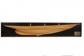 HALF HULL - Ship 'Atlantic' 135'
 LWL Aux Schooner designed by Gardiner & Cox New York 1903 in laminated poplar and mahogany on black painted backboard with brass nameplate 47'' hull 9'' x 51 1/4'' overall fine condition.
HALF HULL - Ship 'Atlantic' 135'
HALF HULL - Ship 'Atlantic' 135' LWL Aux Schooner designed by Gardiner & Cox New York 1903 in laminated poplar and mahogany on black painted backboard with brass nameplate 47'' hull 9'' x 51 1/4'' overall fine condition. -
 A Cased Scale Model of a Three-Mast
 Ship titled Atlantic, by Seacraft Classics. Height of case 24 x length 33 x depth 10 inches. Property from Mrs. Louis Fodor, Cleveland, Ohio
A Cased Scale Model of a Three-Mast
A Cased Scale Model of a Three-Mast Ship titled Atlantic, by Seacraft Classics. Height of case 24 x length 33 x depth 10 inches. Property from Mrs. Louis Fodor, Cleveland, Ohio -
 ATLANTIC CITY BOARDWALK Black and
 white photograph: 34 x 43 in. Framed
ATLANTIC CITY BOARDWALK Black and
ATLANTIC CITY BOARDWALK Black and white photograph: 34 x 43 in. Framed -
 BOOK, ATLANTIC COAST; PILOT
 BOSTON TO NEW YORK,QUARTO, SECOND EDITION, WASHINGTON 1880, LEATHER BINDING WITH MARBLEIZED BOARDS, 621 PAGES. APPROXIMATELY 39 PULLOUT MAPS TO INCLUDE MINOT LIGHT, BOSTON BAY & HARBOR, PROVINCETOWN, ENTRANCE TO NANTUCKET SOUND, GULF OF MAINE, BUZZARDS BAY, LONG ISLAND SOUND, ENTRANCE TO NEW YORK BAY AND OTHERS. ALL MAPS APPEAR TO BE IN GOOD CONDITION AND PRESENT. THE TEXT SHOWS LIGHT FOXING, SPINE AND BOARDS ARE SCUFFED AND WORN.
BOOK, ATLANTIC COAST; PILOT
BOOK, ATLANTIC COAST; PILOT BOSTON TO NEW YORK,QUARTO, SECOND EDITION, WASHINGTON 1880, LEATHER BINDING WITH MARBLEIZED BOARDS, 621 PAGES. APPROXIMATELY 39 PULLOUT MAPS TO INCLUDE MINOT LIGHT, BOSTON BAY & HARBOR, PROVINCETOWN, ENTRANCE TO NANTUCKET SOUND, GULF OF MAINE, BUZZARDS BAY, LONG ISLAND SOUND, ENTRANCE TO NEW YORK BAY AND OTHERS. ALL MAPS APPEAR TO BE IN GOOD CONDITION AND PRESENT. THE TEXT SHOWS LIGHT FOXING, SPINE AND BOARDS ARE SCUFFED AND WORN. -
 GUY BEGIN (1944- ): "ATLANTIC
 COLONY PERFUME"serigraph in colors; numbered 91/175 lower left; 21 x 26 inches; 31 3/4 x 36 1/2 inches frame Condition:
GUY BEGIN (1944- ): "ATLANTIC
GUY BEGIN (1944- ): "ATLANTIC COLONY PERFUME"serigraph in colors; numbered 91/175 lower left; 21 x 26 inches; 31 3/4 x 36 1/2 inches frame Condition: -
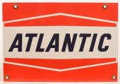 "ATLANTIC" PORCELAIN ENAMELED
 ADVERTISING SIGN."Atlantic" Porcelain Enameled Advertising Sign. 13"w. Condition: : Excellent.
"ATLANTIC" PORCELAIN ENAMELED
"ATLANTIC" PORCELAIN ENAMELED ADVERTISING SIGN."Atlantic" Porcelain Enameled Advertising Sign. 13"w. Condition: : Excellent. -
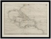
 NORTH ATLANTIC OCEAN, CARIBBEAN
 SEA, REPRODUCTION COLOR PRINT MAP FRAME: 31 1/2 X 43 1/2 IN. (80.01 X 110.49 CM.)North Atlantic Ocean, Caribbean Sea, Reproduction Color Print Map, Dimensions: Frame: 31 1/2 x 43 1/2 in. (80.01 x 110.49 cm.)
NORTH ATLANTIC OCEAN, CARIBBEAN
NORTH ATLANTIC OCEAN, CARIBBEAN SEA, REPRODUCTION COLOR PRINT MAP FRAME: 31 1/2 X 43 1/2 IN. (80.01 X 110.49 CM.)North Atlantic Ocean, Caribbean Sea, Reproduction Color Print Map, Dimensions: Frame: 31 1/2 x 43 1/2 in. (80.01 x 110.49 cm.) -
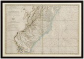
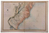 SARTINE - MAP OF THE ATLANTIC
 COAST, 1778 MAPAntoine Sartine (1729-1801), Carte Reduite des Cotes Orientales De L'Amerique Septentrionale Contentant Partie du Nouveau Jersey, la Pen-sylvanie, le Mary-land, la Virginie, la Caroline Septentrionale, la Caroline Meridionale et la Georgie... , Paris, from the French government-issued Neptune Americo-Septentrional (also known as American Neptune), in two sheets, engraving on laid paper with hand colored highlights, plate 23-1/2 x 35 in., sheet 25-1/2 x 37-1/4 in., unframed Provenance: Humber Family, North Carolina Condition: joined at center, some areas of scattered light staining and foxing throughout, wear and small tears to edges, some handling creases, reinforcement at top left corner verso
SARTINE - MAP OF THE ATLANTIC
SARTINE - MAP OF THE ATLANTIC COAST, 1778 MAPAntoine Sartine (1729-1801), Carte Reduite des Cotes Orientales De L'Amerique Septentrionale Contentant Partie du Nouveau Jersey, la Pen-sylvanie, le Mary-land, la Virginie, la Caroline Septentrionale, la Caroline Meridionale et la Georgie... , Paris, from the French government-issued Neptune Americo-Septentrional (also known as American Neptune), in two sheets, engraving on laid paper with hand colored highlights, plate 23-1/2 x 35 in., sheet 25-1/2 x 37-1/4 in., unframed Provenance: Humber Family, North Carolina Condition: joined at center, some areas of scattered light staining and foxing throughout, wear and small tears to edges, some handling creases, reinforcement at top left corner verso -
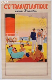 Campagni Generale Transatlantique
 Poster ''Linea Francesa'' 39'' x 24 3/8'' circa 1930
Campagni Generale Transatlantique
Campagni Generale Transatlantique Poster ''Linea Francesa'' 39'' x 24 3/8'' circa 1930 -
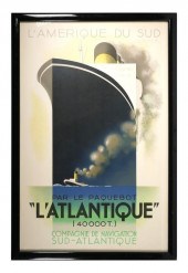 A.M. CASSANDRE, L'ATLANTIQUE,
 MOURLOTOriginal image 1931. Restrike circa 1983. Published by Henri Mouron and printed by Mourlot, France. Overall framed size is 42" x 28". Excellent condition. Wear to framing. shipping info This item will need to be shipped by a packing company of your choice. We maintain a list of reliable shippers, or you may choose your own.
A.M. CASSANDRE, L'ATLANTIQUE,
A.M. CASSANDRE, L'ATLANTIQUE, MOURLOTOriginal image 1931. Restrike circa 1983. Published by Henri Mouron and printed by Mourlot, France. Overall framed size is 42" x 28". Excellent condition. Wear to framing. shipping info This item will need to be shipped by a packing company of your choice. We maintain a list of reliable shippers, or you may choose your own. -
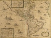
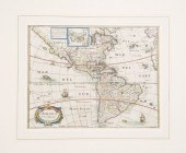 Rare Hand-Colored Engraved Map of
 America, ca. 1665-1670, by Matthaux Merian the Younger (1621-1687), showing the entire Western Hemisphere, the Atlantic and Pacific oceans, fully titled lower left and presented in a striped French mat of ivory ground with a pale blue watercolor band, a black stripe and an outer gray stripe, sight 11-1/4" x 14".
Rare Hand-Colored Engraved Map of
Rare Hand-Colored Engraved Map of America, ca. 1665-1670, by Matthaux Merian the Younger (1621-1687), showing the entire Western Hemisphere, the Atlantic and Pacific oceans, fully titled lower left and presented in a striped French mat of ivory ground with a pale blue watercolor band, a black stripe and an outer gray stripe, sight 11-1/4" x 14". -
 Revolutionary War map of the
 Eastern Seaboard, "Carte Reduite des Cotes Orientales De L'Amerique Septentriole…" by Antoine Sartine, showing portions of New Jersey, Maryland, Pennsylvania, Virginia, North and South Carolina, and Georgia, included in Neptune Americo-Septentrional , published by the Depot General de La Marine (French government agency of nautical charts), 1778, for use by the French navy during the American Revolution, hand-colored copper engraving on wove paper, page 23-3/4 x 36-1/4 in.; modern wood frame. Hinged with archival tape, toning, foxing, stains, tears and losses in margins, 1-3/4 in. tear at left affecting plate, 4 x 1-1/2 in. corner loss upper right, other corner losses, creases, rippling, reinforced center crease, pencil inscriptions and paint residue verso.; frame with abrasions. Deaccessioned from MESDA and Old Salem to benefit the Acquisition Fund.
Revolutionary War map of the
Revolutionary War map of the Eastern Seaboard, "Carte Reduite des Cotes Orientales De L'Amerique Septentriole…" by Antoine Sartine, showing portions of New Jersey, Maryland, Pennsylvania, Virginia, North and South Carolina, and Georgia, included in Neptune Americo-Septentrional , published by the Depot General de La Marine (French government agency of nautical charts), 1778, for use by the French navy during the American Revolution, hand-colored copper engraving on wove paper, page 23-3/4 x 36-1/4 in.; modern wood frame. Hinged with archival tape, toning, foxing, stains, tears and losses in margins, 1-3/4 in. tear at left affecting plate, 4 x 1-1/2 in. corner loss upper right, other corner losses, creases, rippling, reinforced center crease, pencil inscriptions and paint residue verso.; frame with abrasions. Deaccessioned from MESDA and Old Salem to benefit the Acquisition Fund. -
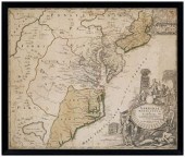 18th century map, eastern United
 States, "Virginia Marylandia et Carolina, in America Septentrionali, Brittanorum industria exclutae…" by Johann Baptist Homann, originally published in Homann's Atlas Novus , Nuremberg, Germany, 1714, showing New York southward to the Carolinas, fictional "Apalache Lacus" pictured lower left, ornate title cartouche lower right showing British merchants with trade goods, Native Americans, wild animals, tobacco and drying shed, hand-colored engraving on laid paper, 19-3/4 x 23 in. (page); modern wood frame. Laid down on acidic card, foxing, toning, stains, fading, trimmed including plate marks, ink inscriptions in title cartouche, other pencil and ink inscriptions; frame with abrasions. Estate of the Late Nathan and Mary Anne McCarley, Asheville, North Carolina.
18th century map, eastern United
18th century map, eastern United States, "Virginia Marylandia et Carolina, in America Septentrionali, Brittanorum industria exclutae…" by Johann Baptist Homann, originally published in Homann's Atlas Novus , Nuremberg, Germany, 1714, showing New York southward to the Carolinas, fictional "Apalache Lacus" pictured lower left, ornate title cartouche lower right showing British merchants with trade goods, Native Americans, wild animals, tobacco and drying shed, hand-colored engraving on laid paper, 19-3/4 x 23 in. (page); modern wood frame. Laid down on acidic card, foxing, toning, stains, fading, trimmed including plate marks, ink inscriptions in title cartouche, other pencil and ink inscriptions; frame with abrasions. Estate of the Late Nathan and Mary Anne McCarley, Asheville, North Carolina. -
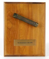 C.1858 MOUNTED SECTION OF THE
 TRANSATLANTIC CABLE United States,Circa 1858Presentation plaque states "The Transatlantic Cable 1858", tag on verso from National Museum of History and Technology, Smithsonian Institution, explains that "...In American cities parades, fireworks and sermons celebrated the event. A New York jeweler, Tiffany, bought up excess cable from one of the two laying ships and cut it into souvenir samples, one of which is displayed here".
C.1858 MOUNTED SECTION OF THE
C.1858 MOUNTED SECTION OF THE TRANSATLANTIC CABLE United States,Circa 1858Presentation plaque states "The Transatlantic Cable 1858", tag on verso from National Museum of History and Technology, Smithsonian Institution, explains that "...In American cities parades, fireworks and sermons celebrated the event. A New York jeweler, Tiffany, bought up excess cable from one of the two laying ships and cut it into souvenir samples, one of which is displayed here". -
 1631 HONDIO AMERICA NOVITER
 DELINEATA MAP: Features North & South America, coast of Europe and Africa, Atlantic and Pacific Oceans. This is a later state map, after the vignettes had been removed. Sight size 15'' x 20'', framed 22'' x 26 1/4''.CONDITION: Note fold line, traces of color, overall toning of paper. Map has been laid down
1631 HONDIO AMERICA NOVITER
1631 HONDIO AMERICA NOVITER DELINEATA MAP: Features North & South America, coast of Europe and Africa, Atlantic and Pacific Oceans. This is a later state map, after the vignettes had been removed. Sight size 15'' x 20'', framed 22'' x 26 1/4''.CONDITION: Note fold line, traces of color, overall toning of paper. Map has been laid down -
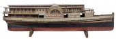 FOLK ART PADDLEWHEELER ATLANTIC
 LARGE SHIP MODEL19th century, carved and painted wooden model after steamboat "Atlantic" operated by "Michigan Central Rail Road Line" and so marked at both sides, resting on two wooden stands, 36 x 10 x 7 in. Provenance: Private Collection, Morristown, Tennessee Condition: typical surface rub especially where making contact with stand, areas of paint loss giving a rustic aesthetic throughout, minor material losses
FOLK ART PADDLEWHEELER ATLANTIC
FOLK ART PADDLEWHEELER ATLANTIC LARGE SHIP MODEL19th century, carved and painted wooden model after steamboat "Atlantic" operated by "Michigan Central Rail Road Line" and so marked at both sides, resting on two wooden stands, 36 x 10 x 7 in. Provenance: Private Collection, Morristown, Tennessee Condition: typical surface rub especially where making contact with stand, areas of paint loss giving a rustic aesthetic throughout, minor material losses -
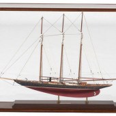
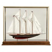 CASED MODEL OF THE SCHOONER YACHT
 "ATLANTIC"Cased Ship Model of The Atlantic. Highly detailed model of the Schooner Yacht Atlantic. Details include winch, ventilators, companionways, masts, booms, rigging and full suite of stitched linen sails, anchor and davit, engine room lights, funnel, deck lights, cleats etc. The hull is painted black above the waterline and red below. The model is mounted into a brass and glass display case with marquetry inlay. 27 1/2" x 35" x 11". 20th c. Very good condition.
CASED MODEL OF THE SCHOONER YACHT
CASED MODEL OF THE SCHOONER YACHT "ATLANTIC"Cased Ship Model of The Atlantic. Highly detailed model of the Schooner Yacht Atlantic. Details include winch, ventilators, companionways, masts, booms, rigging and full suite of stitched linen sails, anchor and davit, engine room lights, funnel, deck lights, cleats etc. The hull is painted black above the waterline and red below. The model is mounted into a brass and glass display case with marquetry inlay. 27 1/2" x 35" x 11". 20th c. Very good condition. -
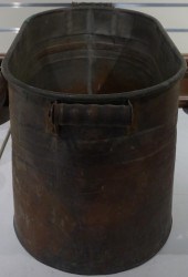 COPPER FISH POACHER BY
 ATLANTICCopper Fish Poacher by Atlantic,
COPPER FISH POACHER BY
COPPER FISH POACHER BY ATLANTICCopper Fish Poacher by Atlantic, -
 EHRIG William C. Oil on Canvas
 ''Atlantic Coast.''Signed lower right. Inscribed verso. William Columbus Ehrig American 1892 - 1973. From a Bronxville NY location. Dimensions: 28'' high x 38'' wide. Condition: Good.
EHRIG William C. Oil on Canvas
EHRIG William C. Oil on Canvas ''Atlantic Coast.''Signed lower right. Inscribed verso. William Columbus Ehrig American 1892 - 1973. From a Bronxville NY location. Dimensions: 28'' high x 38'' wide. Condition: Good. -
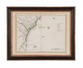
 Coastal map of the Carolinas by
 George Louis Le Rouge Paris circa 1777 NOUVELLE CARTE DES COTES DES CAROLINES SEPTENTRIONALES ET MERIDIONALES DU CAP FEAR A SUD EDISTO as published in ATLAS AMERIQUAIN SEPTENTRIONALE. Matted framed and uncolored. plate size: H16 1/2'' W21 1/2'' Provenance: Columbia South Carolina private collection. Good overall condition; hinged at top with tape; light matteburning; few small and light spots of discoloration; center crease.
Coastal map of the Carolinas by
Coastal map of the Carolinas by George Louis Le Rouge Paris circa 1777 NOUVELLE CARTE DES COTES DES CAROLINES SEPTENTRIONALES ET MERIDIONALES DU CAP FEAR A SUD EDISTO as published in ATLAS AMERIQUAIN SEPTENTRIONALE. Matted framed and uncolored. plate size: H16 1/2'' W21 1/2'' Provenance: Columbia South Carolina private collection. Good overall condition; hinged at top with tape; light matteburning; few small and light spots of discoloration; center crease. -
 FRAMED MAP AFTER J.B. HOMANNDominia
 Anglorum in America Septentrionali''. 20'' x 22'' sight. Overall 28'' x 30''.''
FRAMED MAP AFTER J.B. HOMANNDominia
FRAMED MAP AFTER J.B. HOMANNDominia Anglorum in America Septentrionali''. 20'' x 22'' sight. Overall 28'' x 30''.'' -
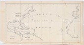
 ENGRAVED MAP OF THE
 ATLANTICEngraved map of the Atlantic detailing the voyage of Antoine Knivets, 8 3/4" x 11 1/2". Competitive in-house shipping is available for this lot. Condition: Good condition. No apparent damages or repairs.
ENGRAVED MAP OF THE
ENGRAVED MAP OF THE ATLANTICEngraved map of the Atlantic detailing the voyage of Antoine Knivets, 8 3/4" x 11 1/2". Competitive in-house shipping is available for this lot. Condition: Good condition. No apparent damages or repairs.
...many more examples with full details are available to our members - Learn more
Easy & Visual methods to Identify & Appraise Antiques & Collectibles
EASY. FAST. ACCURATE.
Research at its best
We are here to help!
Our research tools include:

Thousands of makers marks for PORCELAIN, POTTERY CHINAWARE, FIGURINES, VASES
see details...

Thousands of marks & hallmarks for SILVER & JEWELRY, PEWTER, PRECIOUS METALS, SILVERPLATE
see details...
