Pricing Guides & Dictionary of Makers Marks for Antiques & Collectibles
A few examples of appraisal values for
MASSACHUSETTS AND RHODE ISLAND
Search our price guide for your own treasures
-
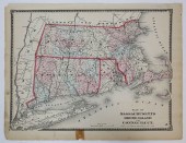
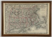
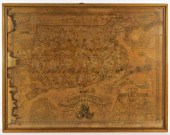
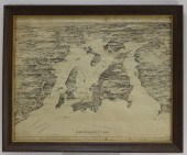
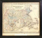 MASSACHUSETTS AND RHODE ISLAND MAP,
 MID 19TH CENTURYMassachusetts and Rhode Island Map, mid 19th Century , published by J.H. Colton and Co., NO. 172 William Street, New York 13.75 in x 15.5 in. Framed 15.5 in. x 17.5 in. Condition: Items may have wear and tear, imperfections or the effects of aging. Please contact the gallery for further details prior to bidding. Any condition statement given as a courtesy should not be treated as fact.
MASSACHUSETTS AND RHODE ISLAND MAP,
MASSACHUSETTS AND RHODE ISLAND MAP, MID 19TH CENTURYMassachusetts and Rhode Island Map, mid 19th Century , published by J.H. Colton and Co., NO. 172 William Street, New York 13.75 in x 15.5 in. Framed 15.5 in. x 17.5 in. Condition: Items may have wear and tear, imperfections or the effects of aging. Please contact the gallery for further details prior to bidding. Any condition statement given as a courtesy should not be treated as fact. -
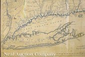
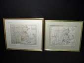 Pair 18th century New England /
 Massachusetts maps. Includes ''A Map of the Province of Massachusetts Bay and Colony of Rhode Island with part of Connecticut New Hampshire and Vermont.'' marked in lower margin ''London Publish'd as the act directs 15th of April 1782 by J Bew Pater Noster Row''. Also includes ''A New and accurate Map of the prefent Seat of War in North America from a late survey.'' no footnote. Both framed matted under glass and unexamined out of frame. Condition: creases to maps see images. Maps measure 15'' wide x 12'' tall. Frames measure 22'' wide and 21'' wide x 19'' tall and 18'' tall respectively. Shipping weight 7.7 lbs.
Pair 18th century New England /
Pair 18th century New England / Massachusetts maps. Includes ''A Map of the Province of Massachusetts Bay and Colony of Rhode Island with part of Connecticut New Hampshire and Vermont.'' marked in lower margin ''London Publish'd as the act directs 15th of April 1782 by J Bew Pater Noster Row''. Also includes ''A New and accurate Map of the prefent Seat of War in North America from a late survey.'' no footnote. Both framed matted under glass and unexamined out of frame. Condition: creases to maps see images. Maps measure 15'' wide x 12'' tall. Frames measure 22'' wide and 21'' wide x 19'' tall and 18'' tall respectively. Shipping weight 7.7 lbs. -
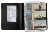 ALBUM: MASSACHUSETTS, RHODE
 ISLAND AND CONNECTICUT VIEWS: 188 POSTCARDS EARLY TO LATE 20TH CENTURYALBUM: MASSACHUSETTS, RHODE ISLAND AND CONNECTICUT VIEWS: 188 POSTCARDS, Early to Late 20th Century, Massachusetts: 7 Nantucket views, 11 Martha's Vineyard scenes, 47 Plymouth views and subjects, 27 Duxbury scenes, as well as views of Marshfield, New Bedford, Fall River, Chatham, general cape Cod subjects & more. Rhode Island: 28 Newport scenes, 2 Watch HillRocky Point, Pawtucket & more. CT: 3 postcards & a Savin Rock folder.
ALBUM: MASSACHUSETTS, RHODE
ALBUM: MASSACHUSETTS, RHODE ISLAND AND CONNECTICUT VIEWS: 188 POSTCARDS EARLY TO LATE 20TH CENTURYALBUM: MASSACHUSETTS, RHODE ISLAND AND CONNECTICUT VIEWS: 188 POSTCARDS, Early to Late 20th Century, Massachusetts: 7 Nantucket views, 11 Martha's Vineyard scenes, 47 Plymouth views and subjects, 27 Duxbury scenes, as well as views of Marshfield, New Bedford, Fall River, Chatham, general cape Cod subjects & more. Rhode Island: 28 Newport scenes, 2 Watch HillRocky Point, Pawtucket & more. CT: 3 postcards & a Savin Rock folder. -
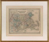 MAP OF MASSACHUSETTS AND RHODE
 ISLAND 19TH CENTURY 13” X 16” SIGHT. FRAMED 21” X 24.5”.MAP OF MASSACHUSETTS AND RHODE ISLAND, 19th Century, By J.H. Colton & Co.. Dated 1855. Dimensions: 13" x 16" sight. Framed 21" x 24.5".
MAP OF MASSACHUSETTS AND RHODE
MAP OF MASSACHUSETTS AND RHODE ISLAND 19TH CENTURY 13” X 16” SIGHT. FRAMED 21” X 24.5”.MAP OF MASSACHUSETTS AND RHODE ISLAND, 19th Century, By J.H. Colton & Co.. Dated 1855. Dimensions: 13" x 16" sight. Framed 21" x 24.5". -
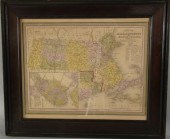
 "PLAN OF MASSACHUSETTS, RHODE
 ISLAND, AND CONNECTICUT-D..."Plan of Massachusetts, Rhode Island, and Connecticut-Drawn and Engraved for this Atlas," 19th Century 12.25 in. x 15 in. Condition: Items may have wear and tear, imperfections or the effects of aging. Please contact the gallery for further details prior to bidding. Any condition statement given as a courtesy should not be treated as fact.
"PLAN OF MASSACHUSETTS, RHODE
"PLAN OF MASSACHUSETTS, RHODE ISLAND, AND CONNECTICUT-D..."Plan of Massachusetts, Rhode Island, and Connecticut-Drawn and Engraved for this Atlas," 19th Century 12.25 in. x 15 in. Condition: Items may have wear and tear, imperfections or the effects of aging. Please contact the gallery for further details prior to bidding. Any condition statement given as a courtesy should not be treated as fact. -
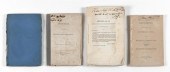 FOUR 19TH CENTURY PAMPHLETS
 PERTAINING TO MASSACHUSETTS - RHODE ISLAND BOUNDARY DISPUTESFOUR 19TH CENTURY PAMPHLETS PERTAINING TO MASSACHUSETTS - RHODE ISLAND BOUNDARY DISPUTES 1-2) Two copies of "Argument, in the Case Rhode-Island Against Massachusetts", printed by order of the General Assembly, Providence, 1838. One with bright blue wraps, one without. 3) "Documents Relating to the Boundary Line, And Disputed Territory, Massachusetts and Rhode-Island", printed by Henry Pratt, Fall River, 1847. 4) Report of the commissioners to the "Senate ... No. 14", submitted Jan. 20, 1848 by Geo. N. Briggs. Tipped-in fold-out map at rear "An exact plan of the Sea Coast of the Continent from Paucatuck River Eastwards to Point Judith ...", a copy of a 1741 map.
FOUR 19TH CENTURY PAMPHLETS
FOUR 19TH CENTURY PAMPHLETS PERTAINING TO MASSACHUSETTS - RHODE ISLAND BOUNDARY DISPUTESFOUR 19TH CENTURY PAMPHLETS PERTAINING TO MASSACHUSETTS - RHODE ISLAND BOUNDARY DISPUTES 1-2) Two copies of "Argument, in the Case Rhode-Island Against Massachusetts", printed by order of the General Assembly, Providence, 1838. One with bright blue wraps, one without. 3) "Documents Relating to the Boundary Line, And Disputed Territory, Massachusetts and Rhode-Island", printed by Henry Pratt, Fall River, 1847. 4) Report of the commissioners to the "Senate ... No. 14", submitted Jan. 20, 1848 by Geo. N. Briggs. Tipped-in fold-out map at rear "An exact plan of the Sea Coast of the Continent from Paucatuck River Eastwards to Point Judith ...", a copy of a 1741 map. -
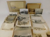 22 RHODE ISLAND BLACK & WHITE
 MARITIME PHOTOGRAPHS Rhode Island,Early 20th CenturyCollection of twenty-two original black and white photographs documenting Rhode Island's maritime business including Providence Harbor, Warwick paddle boat, Connecticut paddle boat, and more.
22 RHODE ISLAND BLACK & WHITE
22 RHODE ISLAND BLACK & WHITE MARITIME PHOTOGRAPHS Rhode Island,Early 20th CenturyCollection of twenty-two original black and white photographs documenting Rhode Island's maritime business including Providence Harbor, Warwick paddle boat, Connecticut paddle boat, and more. -
 THOMAS COWPERTHWAIT (AMERICAN
 19TH CENTURY) MAP OF MASSACHUSETTS AND RHODE ISLAND 12 1/2 x 15 1/2 in. Framed
THOMAS COWPERTHWAIT (AMERICAN
THOMAS COWPERTHWAIT (AMERICAN 19TH CENTURY) MAP OF MASSACHUSETTS AND RHODE ISLAND 12 1/2 x 15 1/2 in. Framed -
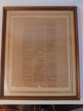
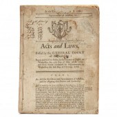 LEGISLATIVE PROCEEDINGS IN
 MASSACHUSETTS, 1786 AND 1787 Being Acts and Laws, Passed by the General Court of Massachusetts: Begun and held at Boston, in the County of Suffolk, on Wednesday the 25th Day of May, A.D. 1785; and from thence continued, by Adjournments, to Wednesday the first Day of February, 1786 quarto (10-1/4), no wraps, bound with string. Topics, in part, include fishing, Penobscot Indians, rioting, taxes, highways and more.
LEGISLATIVE PROCEEDINGS IN
LEGISLATIVE PROCEEDINGS IN MASSACHUSETTS, 1786 AND 1787 Being Acts and Laws, Passed by the General Court of Massachusetts: Begun and held at Boston, in the County of Suffolk, on Wednesday the 25th Day of May, A.D. 1785; and from thence continued, by Adjournments, to Wednesday the first Day of February, 1786 quarto (10-1/4), no wraps, bound with string. Topics, in part, include fishing, Penobscot Indians, rioting, taxes, highways and more. -
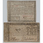 Two Pieces of Colonial Currency Lot
 of 2 including State of Rhode Island and Providence Plantations Four Dollar Note dated July 2 1780 (No. 71); plus Maryland Two Dollars Note dated April 10 1774 (No. 11007). Both pieces of currency hand-signed and hand-numbered.
Two Pieces of Colonial Currency Lot
Two Pieces of Colonial Currency Lot of 2 including State of Rhode Island and Providence Plantations Four Dollar Note dated July 2 1780 (No. 71); plus Maryland Two Dollars Note dated April 10 1774 (No. 11007). Both pieces of currency hand-signed and hand-numbered. -
 JOHNSON'S MAP OF MASSACHUSETTS,
 CONNECTICUT AND RHODE ISLAND CIRCA 1862 18" X 26" SIGHT. FRAMED 20" X 28".JOHNSON'S MAP OF MASSACHUSETTS, CONNECTICUT AND RHODE ISLAND, Circa 1862, A detailed map including roads and railroad lines. Dimensions: 18" x 26" sight. Framed 20" x 28".
JOHNSON'S MAP OF MASSACHUSETTS,
JOHNSON'S MAP OF MASSACHUSETTS, CONNECTICUT AND RHODE ISLAND CIRCA 1862 18" X 26" SIGHT. FRAMED 20" X 28".JOHNSON'S MAP OF MASSACHUSETTS, CONNECTICUT AND RHODE ISLAND, Circa 1862, A detailed map including roads and railroad lines. Dimensions: 18" x 26" sight. Framed 20" x 28". -
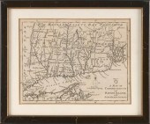
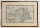 Map of states of N.Y. New Hampshire
 Vermont Massachusetts Rhode Island And Connecticut. Sight 13 1/2'' x 21''.
Map of states of N.Y. New Hampshire
Map of states of N.Y. New Hampshire Vermont Massachusetts Rhode Island And Connecticut. Sight 13 1/2'' x 21''. -
 (VIEW) RHODE ISLAND AND
 CONNECTICUT: 160 POSTCARDS EARLY TO LATE-20TH CENTURY(VIEW) RHODE ISLAND AND CONNECTICUT: 160 POSTCARDS, Early to Late-20th Century, RI (70 cards) includes: 14 call letters, real photo Wickford House and Brownell House, fold-out of Old Stone Mill, "Reaching Land in the Breeches Buoy" (wreck of the "Spartan"), two Rotographs of "Block Island", Elizabeth Mill (Hills Grove), Central Police Station (Woonsocket), 3 Camp Hoffman cards, 50's Camp Yawgoog Sunday Dress Parade and 23 chromes. CT (90 cards) includes: Lakeville Fire House and Village Park with negative, log cabin (Bristol), Westover School for Girls with tennis courts, several early Main Street views, Tuck of Yale University, Rotographs of Waterbury street scene and Old Sheffield Scientific Building at Yale, Steeplechase Island and 29 chromes. Provenance: A private New Bedford, Massachusetts collection.
(VIEW) RHODE ISLAND AND
(VIEW) RHODE ISLAND AND CONNECTICUT: 160 POSTCARDS EARLY TO LATE-20TH CENTURY(VIEW) RHODE ISLAND AND CONNECTICUT: 160 POSTCARDS, Early to Late-20th Century, RI (70 cards) includes: 14 call letters, real photo Wickford House and Brownell House, fold-out of Old Stone Mill, "Reaching Land in the Breeches Buoy" (wreck of the "Spartan"), two Rotographs of "Block Island", Elizabeth Mill (Hills Grove), Central Police Station (Woonsocket), 3 Camp Hoffman cards, 50's Camp Yawgoog Sunday Dress Parade and 23 chromes. CT (90 cards) includes: Lakeville Fire House and Village Park with negative, log cabin (Bristol), Westover School for Girls with tennis courts, several early Main Street views, Tuck of Yale University, Rotographs of Waterbury street scene and Old Sheffield Scientific Building at Yale, Steeplechase Island and 29 chromes. Provenance: A private New Bedford, Massachusetts collection. -
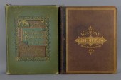 2 PROVIDENCE RHODE ISLAND HISTORY
 ANTIQUARIAN BOOK United States,19th CenturyIncludes two books, History of The State of Rhode Island with Illustrations from Original Sketches, Hoag, Wade * Co., Philadelphia, 1878 and The Providence Plantations for 250 Years, Welcome Arnold Greene, J.A. & R.A. Reid, Publishers and Printers, 1886.
2 PROVIDENCE RHODE ISLAND HISTORY
2 PROVIDENCE RHODE ISLAND HISTORY ANTIQUARIAN BOOK United States,19th CenturyIncludes two books, History of The State of Rhode Island with Illustrations from Original Sketches, Hoag, Wade * Co., Philadelphia, 1878 and The Providence Plantations for 250 Years, Welcome Arnold Greene, J.A. & R.A. Reid, Publishers and Printers, 1886. -
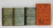 4PC ANTIQUE RHODE ISLAND MASS
 DIRECTORY BOOKS United States,1854-1957Includes three Providence Directory books, one from 1857, 1856, and 1852-53, and a Massachusetts Merchants Reporting Service book from 1957.
4PC ANTIQUE RHODE ISLAND MASS
4PC ANTIQUE RHODE ISLAND MASS DIRECTORY BOOKS United States,1854-1957Includes three Providence Directory books, one from 1857, 1856, and 1852-53, and a Massachusetts Merchants Reporting Service book from 1957. -
 1836 A.F WILCOX NEW ENGLAND
 TRI-STATE ENGRAVED MAP United States,1836Highly detailed map of Massachusetts, Rhode Island, and Connecticut. Engraved by J. Wells, New York, published by A.F. Wilcox Middletown, Connecticut; Light & Stearns, Boston; C. Shepard, New York & Providence. Prime meridian: Washington [D.C.] and Greenwich. Shows roads, railroads, mills, factories and churches. Includes illustrations. Insets: Norwich, Conn. and factories; Fall River, Mass. and factories; New-Haven; Salem; City of Lowell; New Britain, Conn. manufactories; New-York; North Adams, Mass. manufactories, Boston; Canton factories, Mass.; Warwick & Coventry factories, R.I.; Pawtucket and Central Falls manufactories; Hartford; Woonsocket Falls, R.I. & factories; Providence. Scale ca 1:464,000
1836 A.F WILCOX NEW ENGLAND
1836 A.F WILCOX NEW ENGLAND TRI-STATE ENGRAVED MAP United States,1836Highly detailed map of Massachusetts, Rhode Island, and Connecticut. Engraved by J. Wells, New York, published by A.F. Wilcox Middletown, Connecticut; Light & Stearns, Boston; C. Shepard, New York & Providence. Prime meridian: Washington [D.C.] and Greenwich. Shows roads, railroads, mills, factories and churches. Includes illustrations. Insets: Norwich, Conn. and factories; Fall River, Mass. and factories; New-Haven; Salem; City of Lowell; New Britain, Conn. manufactories; New-York; North Adams, Mass. manufactories, Boston; Canton factories, Mass.; Warwick & Coventry factories, R.I.; Pawtucket and Central Falls manufactories; Hartford; Woonsocket Falls, R.I. & factories; Providence. Scale ca 1:464,000 -
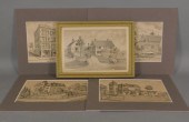 5PC 19C. RHODE ISLAND ARCHITECTURAL
 ETCHING GROUP United States,19th CenturyGroup includes five etchings of Rhode Island architecture including the Hoppin Homestead Building, residence of Nathaniel Grant, and residence of Albert Mowry in Providence, and two of the residence of George W. Miller Esq. in Woonsocket, Rhode Island.
5PC 19C. RHODE ISLAND ARCHITECTURAL
5PC 19C. RHODE ISLAND ARCHITECTURAL ETCHING GROUP United States,19th CenturyGroup includes five etchings of Rhode Island architecture including the Hoppin Homestead Building, residence of Nathaniel Grant, and residence of Albert Mowry in Providence, and two of the residence of George W. Miller Esq. in Woonsocket, Rhode Island. -
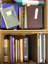 Extensive collection of books on
 New England history with an emphasis on Rhode Island. 5 boxes.
Extensive collection of books on
Extensive collection of books on New England history with an emphasis on Rhode Island. 5 boxes. -
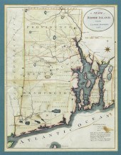 1796 STATE OF RHODE ISLAND HAND
 COLORED MAP New York,Dated 1796Map of the State of Rhode Island as updated by the latest surveys,1796, hand colored on laid paper, engraved for the American edition of Winterbothams America, published by John Reid, New York.
1796 STATE OF RHODE ISLAND HAND
1796 STATE OF RHODE ISLAND HAND COLORED MAP New York,Dated 1796Map of the State of Rhode Island as updated by the latest surveys,1796, hand colored on laid paper, engraved for the American edition of Winterbothams America, published by John Reid, New York. -
 5 RHODE ISLAND STATE OFFICIAL BRASS
 SCALE WEIGHTS United States,Early 20th CenturyIncludes 2 complete and 3 incomplete sets, one identified "Town of Barrington, R.I.".
5 RHODE ISLAND STATE OFFICIAL BRASS
5 RHODE ISLAND STATE OFFICIAL BRASS SCALE WEIGHTS United States,Early 20th CenturyIncludes 2 complete and 3 incomplete sets, one identified "Town of Barrington, R.I.". -
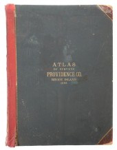 MASSIVE RHODE ISLAND ATLAS
 1895The last half of the 19th century spawned many states to create atlases of their counties, showing names of land owners. This one is of Providence County, Rhode Island ,best known for being the home of Providence, Cranston, Pawtucket and many smaller towns. Published in 1895 by Everts and Richards, it contains 199 pages- giant pages, 23" x 16", printed on heavy paper. It has 47 double pages of maps, blank on the backside. City areas have names of business and lot number; country areas have owner's name, location of their house, and acre size of their land as well as exact boundaries, all in high detail. Maps are hand colored. There is even a "driving map" of the county and state, showing all roads in color. These maps are wonderful for genealogy and historical research. Like most of these old county atlases, covers show heavy use and wear. This one has its spine repaired with heavy red cloth tape. Nothing seems to be missing, though a few non-map pages have tears and there is a damp stain at the bottom going in for 10 or 15 pages. No real foxing apparent. Still totally useful and fascinating.
MASSIVE RHODE ISLAND ATLAS
MASSIVE RHODE ISLAND ATLAS 1895The last half of the 19th century spawned many states to create atlases of their counties, showing names of land owners. This one is of Providence County, Rhode Island ,best known for being the home of Providence, Cranston, Pawtucket and many smaller towns. Published in 1895 by Everts and Richards, it contains 199 pages- giant pages, 23" x 16", printed on heavy paper. It has 47 double pages of maps, blank on the backside. City areas have names of business and lot number; country areas have owner's name, location of their house, and acre size of their land as well as exact boundaries, all in high detail. Maps are hand colored. There is even a "driving map" of the county and state, showing all roads in color. These maps are wonderful for genealogy and historical research. Like most of these old county atlases, covers show heavy use and wear. This one has its spine repaired with heavy red cloth tape. Nothing seems to be missing, though a few non-map pages have tears and there is a damp stain at the bottom going in for 10 or 15 pages. No real foxing apparent. Still totally useful and fascinating. -
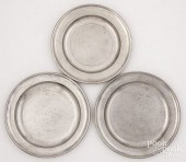 THREE MASSACHUSETTS AND RHODE
 ISLAND PEWTER PLATESThree Massachusetts and Rhode Island pewter plates, 18th/19th c., bearing the touches of Samuel Pierce, Semper Eadem, and David Melville, 7 3/4" dia. - 8 1/4" dia. Competitive in-house shipping is available for this lot. Condition: Good with some light knife marks.
THREE MASSACHUSETTS AND RHODE
THREE MASSACHUSETTS AND RHODE ISLAND PEWTER PLATESThree Massachusetts and Rhode Island pewter plates, 18th/19th c., bearing the touches of Samuel Pierce, Semper Eadem, and David Melville, 7 3/4" dia. - 8 1/4" dia. Competitive in-house shipping is available for this lot. Condition: Good with some light knife marks. -
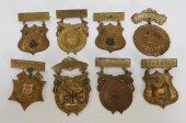 8 WWI ERA BRITISH DAY SOUVENIR
 MEDAL PINS RI MADE Massachusetts, Rhode Island,1906-1913Shield and cartouche form embossed medals with enamel decorations representing British Americans. Manufactures including J.W. Greenhalgh, Pawtucket, Rhode Island and C.M. Robbins & Co., Attleboro, Massachusetts.
8 WWI ERA BRITISH DAY SOUVENIR
8 WWI ERA BRITISH DAY SOUVENIR MEDAL PINS RI MADE Massachusetts, Rhode Island,1906-1913Shield and cartouche form embossed medals with enamel decorations representing British Americans. Manufactures including J.W. Greenhalgh, Pawtucket, Rhode Island and C.M. Robbins & Co., Attleboro, Massachusetts. -
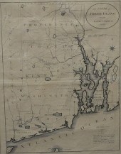
 JOHN COBB NARRAGANSETT BAY RHODE
 ISLAND MAP Massachusetts,20th CenturyAerial view map with scenic landscape decoration of Narragansett Bay.
JOHN COBB NARRAGANSETT BAY RHODE
JOHN COBB NARRAGANSETT BAY RHODE ISLAND MAP Massachusetts,20th CenturyAerial view map with scenic landscape decoration of Narragansett Bay. -
 Braddock Mead (British 1688-1757)
 and Thomas Jefferys/Publisher "A Map of the most Inhabited part of New England containing the Provinces of Massachusets Bay and New Hampshire with the Colonies of Conecticut and Rhode Island Divided into Counties and Townships..." published November 29 1774 Thomas Jefferys London hand-colored copper-engraved four sheet map featuring an inset city map of Boston another of Boston Harbor also with a delightful cartouche depicting the Pilgrims arriving at Plymouth Rock 42 in. x 39 1/2 in. Note: This was the largest and most detailed map of New England published during the Revolutionary period. It was used by both sides for tactical planning and was used after the war to settle boundary disputes.
Braddock Mead (British 1688-1757)
Braddock Mead (British 1688-1757) and Thomas Jefferys/Publisher "A Map of the most Inhabited part of New England containing the Provinces of Massachusets Bay and New Hampshire with the Colonies of Conecticut and Rhode Island Divided into Counties and Townships..." published November 29 1774 Thomas Jefferys London hand-colored copper-engraved four sheet map featuring an inset city map of Boston another of Boston Harbor also with a delightful cartouche depicting the Pilgrims arriving at Plymouth Rock 42 in. x 39 1/2 in. Note: This was the largest and most detailed map of New England published during the Revolutionary period. It was used by both sides for tactical planning and was used after the war to settle boundary disputes. -
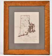 ANTIQUE PRIMITIVE RI MAP. Map in
 ink and watercolor of Rhode Island, in a birds eye maple frame. Image 9” x 7”, overall 15” x 13.5”.
ANTIQUE PRIMITIVE RI MAP. Map in
ANTIQUE PRIMITIVE RI MAP. Map in ink and watercolor of Rhode Island, in a birds eye maple frame. Image 9” x 7”, overall 15” x 13.5”. -
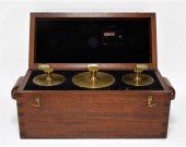 RHODE ISLAND STATE OFFICIAL 900OZ
 SCALE WEIGHT SET United States,Early 20th CenturyIncludes three weights, one 500 oz and two 200 oz.
RHODE ISLAND STATE OFFICIAL 900OZ
RHODE ISLAND STATE OFFICIAL 900OZ SCALE WEIGHT SET United States,Early 20th CenturyIncludes three weights, one 500 oz and two 200 oz. -
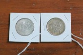 TWO COMMEMORATIVE SILVER HALF
 DOLLARS. Stone Mountain Memorial 1925. Rhode Island 1936.
TWO COMMEMORATIVE SILVER HALF
TWO COMMEMORATIVE SILVER HALF DOLLARS. Stone Mountain Memorial 1925. Rhode Island 1936. -
 RARE MAP OF THE BATTLE OF RHODE
 ISLAND, DATEDAugust 29, 1778. Drawn by Sabin Lewis. Engraved by Benjamin Jones, Philadelphia. Engraving, map shows the locations of the American and British armies in specific towns along Narragansett Bay, as well as the locations of the British and French fleets. The title reads "A Map of Part of Rhode Island Shewing (sic) the Positions of the American and British Armies at the Siege of Newport, and the Subsequent Action of the 29th of August, 1778". Shows a 3" tear in the upper left corner, a small chip off of the right corner, very minor chipping on the edges, and the bottom margin has been slightly trimmed. The map appears to once have been folded and is taped across the center horizontally in the back. 17" x 10". Verso reads "F. Nordytrone, Malden, Maps, 1919", probably the name of an antique map retailer.
RARE MAP OF THE BATTLE OF RHODE
RARE MAP OF THE BATTLE OF RHODE ISLAND, DATEDAugust 29, 1778. Drawn by Sabin Lewis. Engraved by Benjamin Jones, Philadelphia. Engraving, map shows the locations of the American and British armies in specific towns along Narragansett Bay, as well as the locations of the British and French fleets. The title reads "A Map of Part of Rhode Island Shewing (sic) the Positions of the American and British Armies at the Siege of Newport, and the Subsequent Action of the 29th of August, 1778". Shows a 3" tear in the upper left corner, a small chip off of the right corner, very minor chipping on the edges, and the bottom margin has been slightly trimmed. The map appears to once have been folded and is taped across the center horizontally in the back. 17" x 10". Verso reads "F. Nordytrone, Malden, Maps, 1919", probably the name of an antique map retailer. -
 Three Colonial American
 documents: partly printed deed, "John Lawrence of Providence…Colony of Rhode Island Merchant" grants James Green "a certain Dwelling House…", signed "John Lawrence", August 4, 1760, wax seal, docketed verso, 16-1/2 x 13 in., fold through "Lawrence", minor holes, edge chips, stains ; manuscript account, "…money Recovered of Peter Simon…To Capt. Paul and his Negro…", signed "J. Wanton", Newport, November 6, 1776, 12-1/2 x 7-3/4 in., small holes and fold separations, stains, laid down on cardstock ; partly printed deed, Thomas Greene of Boston grants Edward Barnes of Marlborough land in Southborough, Massachusetts Bay Colony, February 24, 1746, signed "Thos. Greene", docketed on verso, 12-1/2 x 8 in., separations, small holes, stains ; with a 19th century copy of "The Boston News-Letter", issue No. 1, April 24, 1704, the first newspaper published in the English colonies, printed on both sides by B. Green, 11-1/2 x 7-3/4 in., browning, small holes, separations, losses, wrinkles . (Four pieces.) Collection of H. Donald Nelson, Williamsburg, Virginia.
Three Colonial American
Three Colonial American documents: partly printed deed, "John Lawrence of Providence…Colony of Rhode Island Merchant" grants James Green "a certain Dwelling House…", signed "John Lawrence", August 4, 1760, wax seal, docketed verso, 16-1/2 x 13 in., fold through "Lawrence", minor holes, edge chips, stains ; manuscript account, "…money Recovered of Peter Simon…To Capt. Paul and his Negro…", signed "J. Wanton", Newport, November 6, 1776, 12-1/2 x 7-3/4 in., small holes and fold separations, stains, laid down on cardstock ; partly printed deed, Thomas Greene of Boston grants Edward Barnes of Marlborough land in Southborough, Massachusetts Bay Colony, February 24, 1746, signed "Thos. Greene", docketed on verso, 12-1/2 x 8 in., separations, small holes, stains ; with a 19th century copy of "The Boston News-Letter", issue No. 1, April 24, 1704, the first newspaper published in the English colonies, printed on both sides by B. Green, 11-1/2 x 7-3/4 in., browning, small holes, separations, losses, wrinkles . (Four pieces.) Collection of H. Donald Nelson, Williamsburg, Virginia. -
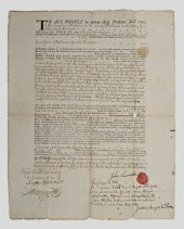
 1790 RI RATIFICATION OF
 CONSTITUTION DOCUMENTFramed original copy of the Ratification of the US Constitution and Amendments by the State of Rhode Island and Providence Plantation in 1790. Attested as a true copy by Daniel Updike. 17.5 x 14 inches, framed 23 x 19 inches. Some loss to paper.
1790 RI RATIFICATION OF
1790 RI RATIFICATION OF CONSTITUTION DOCUMENTFramed original copy of the Ratification of the US Constitution and Amendments by the State of Rhode Island and Providence Plantation in 1790. Attested as a true copy by Daniel Updike. 17.5 x 14 inches, framed 23 x 19 inches. Some loss to paper. -
 THE STATE OF RHODE ISLAND 1796
 ENGRAVED MAP FROM THE LA...The State of Rhode Island 1796 Engraved Map from the latest surveys, published by John Reid, New York plate size: 16 3/4" x 12 3/4" Provenance: The Estate of Diana Atwood Johnson Condition: All lots are sold "AS IS" The condition of lots can vary widely and are unlikely to be in a perfect condition. *No credit card payments will be accepted for silver, gold, or jewelry from buyers that have not purchased from our gallery in the past.
THE STATE OF RHODE ISLAND 1796
THE STATE OF RHODE ISLAND 1796 ENGRAVED MAP FROM THE LA...The State of Rhode Island 1796 Engraved Map from the latest surveys, published by John Reid, New York plate size: 16 3/4" x 12 3/4" Provenance: The Estate of Diana Atwood Johnson Condition: All lots are sold "AS IS" The condition of lots can vary widely and are unlikely to be in a perfect condition. *No credit card payments will be accepted for silver, gold, or jewelry from buyers that have not purchased from our gallery in the past. -
 1776 MAP OF CONNECTICUT AND RHODE
 ISLAND 6.75” X 9” SIGHT. FRAMED 10” X 12”.1776 MAP OF CONNECTICUT AND RHODE ISLAND, From Gentleman's Magazine. Includes a 1976 bill of sale from noted historical manuscript dealer Joseph Rubinfine. Dimensions: 6.75" x 9" sight. Framed 10" x 12".
1776 MAP OF CONNECTICUT AND RHODE
1776 MAP OF CONNECTICUT AND RHODE ISLAND 6.75” X 9” SIGHT. FRAMED 10” X 12”.1776 MAP OF CONNECTICUT AND RHODE ISLAND, From Gentleman's Magazine. Includes a 1976 bill of sale from noted historical manuscript dealer Joseph Rubinfine. Dimensions: 6.75" x 9" sight. Framed 10" x 12". -
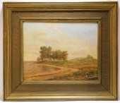 HORACE BURDICK IMPRESSIONIST
 LANDSCAPE PAINTING Massachusetts, Rhode Island, Connecticut,1844-1942Depicts a winding dirt path leading towards a group of trees bathed in early morning sunlight. Burdick studied at the Union Hall School in Providence, The Lowell Institute in Boston, and the Museum School of Fine Arts, Boston where he continued his art career painting landscapes and doing crayon portraits before switching to oil portraits.
HORACE BURDICK IMPRESSIONIST
HORACE BURDICK IMPRESSIONIST LANDSCAPE PAINTING Massachusetts, Rhode Island, Connecticut,1844-1942Depicts a winding dirt path leading towards a group of trees bathed in early morning sunlight. Burdick studied at the Union Hall School in Providence, The Lowell Institute in Boston, and the Museum School of Fine Arts, Boston where he continued his art career painting landscapes and doing crayon portraits before switching to oil portraits. -
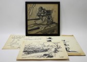 4PC PAULE LORING & JOHN FAWCETT
 ILLUSTRATIONS Rhode Island,20th CenturyIncludes a cartoon of two men chasing each other on a treadmill marked "Southern Textiles" and "New England Textiles" by John Fawcett 1902-1992, an illustration of four personified nations in a canoe heading towards a log marked "Big 4 Meeting at Geneva" with hammer and sickle branches, an illustration titled "American Inspirations" depicting various boats, and an illustration of a Nazi soldier in a tank, all by Paule Loring 1899-1968. Frame 14 1/4" x 14 1/4"
4PC PAULE LORING & JOHN FAWCETT
4PC PAULE LORING & JOHN FAWCETT ILLUSTRATIONS Rhode Island,20th CenturyIncludes a cartoon of two men chasing each other on a treadmill marked "Southern Textiles" and "New England Textiles" by John Fawcett 1902-1992, an illustration of four personified nations in a canoe heading towards a log marked "Big 4 Meeting at Geneva" with hammer and sickle branches, an illustration titled "American Inspirations" depicting various boats, and an illustration of a Nazi soldier in a tank, all by Paule Loring 1899-1968. Frame 14 1/4" x 14 1/4" -
 (VIEW) MASSACHUSETTS: 203 POSTCARDS
 EARLY 20TH CENTURY(VIEW) MASSACHUSETTS: 203 POSTCARDS, Early 20th Century, Includes towns from Newburyport to Warren. Includes: Plum Island Light, good selection of Onset views (Colonial Theatre, harbor views, Holmes' Casino-issued Wichett Island & Yachts), East India Marine Hall (Salem), the wreck of the "Jennie M. Carter", Salisbury Beach Life Saving Station and clam diggers, Taunton herring run, "old seine reel" on Taunton River & more. Provenance: A private New Bedford, Massachusetts collection.
(VIEW) MASSACHUSETTS: 203 POSTCARDS
(VIEW) MASSACHUSETTS: 203 POSTCARDS EARLY 20TH CENTURY(VIEW) MASSACHUSETTS: 203 POSTCARDS, Early 20th Century, Includes towns from Newburyport to Warren. Includes: Plum Island Light, good selection of Onset views (Colonial Theatre, harbor views, Holmes' Casino-issued Wichett Island & Yachts), East India Marine Hall (Salem), the wreck of the "Jennie M. Carter", Salisbury Beach Life Saving Station and clam diggers, Taunton herring run, "old seine reel" on Taunton River & more. Provenance: A private New Bedford, Massachusetts collection.
...many more examples with full details are available to our members - Learn more
Easy & Visual methods to Identify & Appraise Antiques & Collectibles
EASY. FAST. ACCURATE.
Research at its best
We are here to help!
Our research tools include:

Thousands of makers marks for PORCELAIN, POTTERY CHINAWARE, FIGURINES, VASES
see details...

Thousands of marks & hallmarks for SILVER & JEWELRY, PEWTER, PRECIOUS METALS, SILVERPLATE
see details...
