Pricing Guides & Dictionary of Makers Marks for Antiques & Collectibles
A few examples of appraisal values for
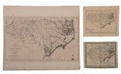
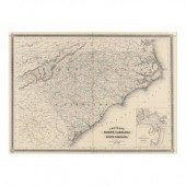
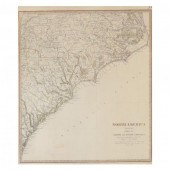
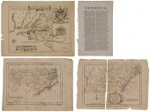
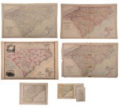
NORTH CAROLINA STATE MAP
Search our price guide for your own treasures
-
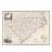
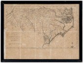 18th century North Carolina map,
 "the State of North Carolina from the best Authorities", engraved by B. Tanner, published in John Reid's American Atlas , New York, 1796, engraving on laid paper, 14-1/2 x 19-1/2 in.; modern wood frame. Laid down on acidic card, toning, foxing, stains, folds, fading, trimmed lower left (affecting plate mark); frame with abrasions. Estate of the Late Nathan and Mary Anne McCarley, Asheville, North Carolina.
18th century North Carolina map,
18th century North Carolina map, "the State of North Carolina from the best Authorities", engraved by B. Tanner, published in John Reid's American Atlas , New York, 1796, engraving on laid paper, 14-1/2 x 19-1/2 in.; modern wood frame. Laid down on acidic card, toning, foxing, stains, folds, fading, trimmed lower left (affecting plate mark); frame with abrasions. Estate of the Late Nathan and Mary Anne McCarley, Asheville, North Carolina. -
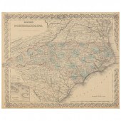
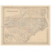
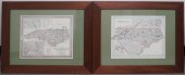
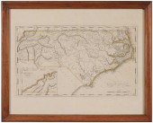 19th Century Map of North
 Carolina "North Carolina", by Samuel Lewis, from Carey's General Atlas…, probably second edition, published by Matthew Carey, Philadelphia, 1814, showing geographic features, town and county names, with inset of western portion of the state, some hand-coloring in outline, on wove paper, 12 x 19-1/4 in. (plate); modern wood frame,
19th Century Map of North
19th Century Map of North Carolina "North Carolina", by Samuel Lewis, from Carey's General Atlas…, probably second edition, published by Matthew Carey, Philadelphia, 1814, showing geographic features, town and county names, with inset of western portion of the state, some hand-coloring in outline, on wove paper, 12 x 19-1/4 in. (plate); modern wood frame, -
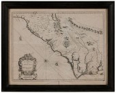
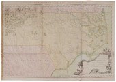 Important 18th Century North
 Carolina Map "A Compleat [sic] Map of North-Carolina from an actual Survey. By Captn. Collet, Governor of Fort Johnson-----engraved by I. Bayly", published by S. Hooper, No. 25 Ludgate Hill, London, 1770, showing North Carolina and adjacent portions of Virginia and South Carolina from the Atlantic coastline west to Table Mountain (probably Table Rock, near modern-day Morganton, North Carolina) in "the Blue Ridge or the Alagany [sic] mountains", named residences, mills, stores, towns and geographic features, coastline with depth soundings, elaborate baroque style cartouche lower right with dedication to King George III and depictions of the English royal crest, an American Indian, an alligator and a wildcat, hand-colored engraving on two joined sheets, laid paper with "J Whatman" watermark, unframed, 30-1/2 x 44-1/2 in. (plate),
Important 18th Century North
Important 18th Century North Carolina Map "A Compleat [sic] Map of North-Carolina from an actual Survey. By Captn. Collet, Governor of Fort Johnson-----engraved by I. Bayly", published by S. Hooper, No. 25 Ludgate Hill, London, 1770, showing North Carolina and adjacent portions of Virginia and South Carolina from the Atlantic coastline west to Table Mountain (probably Table Rock, near modern-day Morganton, North Carolina) in "the Blue Ridge or the Alagany [sic] mountains", named residences, mills, stores, towns and geographic features, coastline with depth soundings, elaborate baroque style cartouche lower right with dedication to King George III and depictions of the English royal crest, an American Indian, an alligator and a wildcat, hand-colored engraving on two joined sheets, laid paper with "J Whatman" watermark, unframed, 30-1/2 x 44-1/2 in. (plate), -
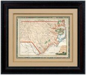 18th century map of North Carolina,
 "A New and Accurate Map of North Carolina in North America", by John Hinton, published in The Universal Magazine of Knowledge and Pleasure , London, October 1779, copper engraving on laid paper with two watermarks and later coloring, certificate of authenticity from Antiquities, Ltd. on backing, 10-1/2 x 14-1/4 in.; modern wood frame. Bright fresh colors, hinged with archival tape, 2-3/4 in. tear at right margin repaired with Scotch tape, approximately 8 x 1/2 in. section of right margin restored (area lacking plate mark, not affecting borders), glue residue, creases, minor separations, toning, foxing, fading, stains, later ink inscriptions and typewritten titles at top and bottom; frame with abrasions. Private Collection, Winston-Salem, North Carolina
18th century map of North Carolina,
18th century map of North Carolina, "A New and Accurate Map of North Carolina in North America", by John Hinton, published in The Universal Magazine of Knowledge and Pleasure , London, October 1779, copper engraving on laid paper with two watermarks and later coloring, certificate of authenticity from Antiquities, Ltd. on backing, 10-1/2 x 14-1/4 in.; modern wood frame. Bright fresh colors, hinged with archival tape, 2-3/4 in. tear at right margin repaired with Scotch tape, approximately 8 x 1/2 in. section of right margin restored (area lacking plate mark, not affecting borders), glue residue, creases, minor separations, toning, foxing, fading, stains, later ink inscriptions and typewritten titles at top and bottom; frame with abrasions. Private Collection, Winston-Salem, North Carolina -
 MAP, JOHNSON'S NORTH AND SOUTH
 CAROLINA (New York: Johnson & Ward, n.d.), steel engraving with color, 1860s, inset vignettes of "Chimney Rocks and French Broad River" plus "Table Mountain," professionally displayed.
MAP, JOHNSON'S NORTH AND SOUTH
MAP, JOHNSON'S NORTH AND SOUTH CAROLINA (New York: Johnson & Ward, n.d.), steel engraving with color, 1860s, inset vignettes of "Chimney Rocks and French Broad River" plus "Table Mountain," professionally displayed. -
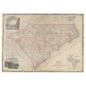
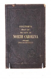
 ANTEBELLUM MAP OF NORTH CAROLINA
 Colton's Map of North Carolina (New York: G. W. and C. B. Colton & Co., 1855), steel engraving with color, behind mat in a modern gilt wooden frame.
ANTEBELLUM MAP OF NORTH CAROLINA
ANTEBELLUM MAP OF NORTH CAROLINA Colton's Map of North Carolina (New York: G. W. and C. B. Colton & Co., 1855), steel engraving with color, behind mat in a modern gilt wooden frame. -
 MAP, JOHNSON'S NORTH AND SOUTH
 CAROLINA New York: Johnson & Ward, n.d.), 1860s, steel engraving with color, inset vignettes of "Chimney Rocks and French Broad River" plus "Table Mountain"; presented in a custom painted wooden frame dated 2012.
MAP, JOHNSON'S NORTH AND SOUTH
MAP, JOHNSON'S NORTH AND SOUTH CAROLINA New York: Johnson & Ward, n.d.), 1860s, steel engraving with color, inset vignettes of "Chimney Rocks and French Broad River" plus "Table Mountain"; presented in a custom painted wooden frame dated 2012. -
 Colonial Map of North Carolina
 South Carolina and Georgia by Emmanuel Bowen Bowen Emmanuel. A NEW & ACCURATE MAP OF THE PROVINCE OF NORTH & SOUTH CAROLINA GEORGIA & C. London: circa 1747. map size: H13 1/2'' W17'' Literature: Cumming William P. THE SOUTHEAST IN EARLY MAPS. Chapel Hill: The University of North Carolina Press 1998 map number 263. Minor waterstaining at bottom margin; reinforced crease at back; toning to paper consistent with age.
Colonial Map of North Carolina
Colonial Map of North Carolina South Carolina and Georgia by Emmanuel Bowen Bowen Emmanuel. A NEW & ACCURATE MAP OF THE PROVINCE OF NORTH & SOUTH CAROLINA GEORGIA & C. London: circa 1747. map size: H13 1/2'' W17'' Literature: Cumming William P. THE SOUTHEAST IN EARLY MAPS. Chapel Hill: The University of North Carolina Press 1998 map number 263. Minor waterstaining at bottom margin; reinforced crease at back; toning to paper consistent with age. -
 Travel maps of North and South
 Carolina consisting of: COLTON'S MAP OF THE STATE OF NORTH CAROLINA WITH PORTIONS OF ADJOINING STATES 1866. Late 19th century in two parts folded and mounted within hardcover book; THE RAND-MCNALLY VEST POCKET MAP OF SOUTH CAROLINA 1913. New York: Rand McNally & Co. 1913. Folded and mounted within soft paper folded case. STANDARD ROAD MAP OF NORTH CAROLINA AND SOUTH CAROLINA. Published by the Standard Oil Company of New Jersey unframed. H17 1/2'' W23 5/8'' (3pcs) Provenance: Columbia South Carolina private collection. Colton’s: multiple tears and staining along creases. Rand-McNally: tears along creases; paper toned. Standard: good original condition with small tear at left margin.
Travel maps of North and South
Travel maps of North and South Carolina consisting of: COLTON'S MAP OF THE STATE OF NORTH CAROLINA WITH PORTIONS OF ADJOINING STATES 1866. Late 19th century in two parts folded and mounted within hardcover book; THE RAND-MCNALLY VEST POCKET MAP OF SOUTH CAROLINA 1913. New York: Rand McNally & Co. 1913. Folded and mounted within soft paper folded case. STANDARD ROAD MAP OF NORTH CAROLINA AND SOUTH CAROLINA. Published by the Standard Oil Company of New Jersey unframed. H17 1/2'' W23 5/8'' (3pcs) Provenance: Columbia South Carolina private collection. Colton’s: multiple tears and staining along creases. Rand-McNally: tears along creases; paper toned. Standard: good original condition with small tear at left margin. -
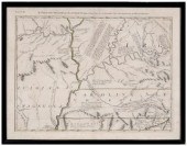
 Revolutionary War Map of North
 Carolina "Map showing the rout
Revolutionary War Map of North
Revolutionary War Map of North Carolina "Map showing the rout -
 Two frames of miscellaneous
 points one North Carolina the other Ohio 16" x 13". ?
Two frames of miscellaneous
Two frames of miscellaneous points one North Carolina the other Ohio 16" x 13". ? -
 ANTEBELLUM MAP, NORTH CAROLINA (New
 York: J. H. Colton & Co., 1855), steel engraving with color, inset plan showing the port of Beaufort; presented behind mat in wooden frame.
ANTEBELLUM MAP, NORTH CAROLINA (New
ANTEBELLUM MAP, NORTH CAROLINA (New York: J. H. Colton & Co., 1855), steel engraving with color, inset plan showing the port of Beaufort; presented behind mat in wooden frame. -
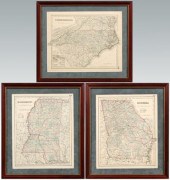 Three 1855 Southern maps: "North
 Carolina", "Georgia" and "Mississippi", published by J. H. Colton and Company, 1855, each hand colored, about 17 x 13-1/2 in.; separately mounted in modern wood frames. Fading to colors, light toning, minor edge losses, archival tape mounts at tops on reverses. Couey Collection.
Three 1855 Southern maps: "North
Three 1855 Southern maps: "North Carolina", "Georgia" and "Mississippi", published by J. H. Colton and Company, 1855, each hand colored, about 17 x 13-1/2 in.; separately mounted in modern wood frames. Fading to colors, light toning, minor edge losses, archival tape mounts at tops on reverses. Couey Collection. -
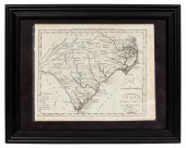 1796 MAP OF NORTH & SOUTH CAROLINA,
 DENISON, FRAME J. Denison (American, 18th century). "Map of North and South Carolina" -1796, from "Morse's Universal Geography", engraving. Framed. Provenance: From the Lifetime Collection of Billy S. Arant, Jr., Chattanooga, TN. Approx. 12" x 15" (frame), 8.25" x 10.25" (sheet)
1796 MAP OF NORTH & SOUTH CAROLINA,
1796 MAP OF NORTH & SOUTH CAROLINA, DENISON, FRAME J. Denison (American, 18th century). "Map of North and South Carolina" -1796, from "Morse's Universal Geography", engraving. Framed. Provenance: From the Lifetime Collection of Billy S. Arant, Jr., Chattanooga, TN. Approx. 12" x 15" (frame), 8.25" x 10.25" (sheet) -
 18th century map of North Carolina,
 "Il Paese de Cherachesi, con la Parte Occidental della Carolina Settentrionale, e Della Virginia", by Antonio Zatta, comprising a section of the Italian edition of Mitchell's 1773 map of North America, from Storia Dell'America Settentrionale… by Antonio Zatta, John Mitchell, G.T. Raynal, Venice, 1778, showing the southeastern region of the United States from the Appalachian mountains west to the Arkansas and Missouri rivers, hand-colored engraving on laid paper, 14-1/2 x 18-3/4 in. (sight); modern wood frame. Probably laid down on acidic card, toning, foxing, stains, fading, creases, not examined out of frame; frame with abrasions. Estate of the Late Nathan and Mary Anne McCarley, Asheville, North Carolina.
18th century map of North Carolina,
18th century map of North Carolina, "Il Paese de Cherachesi, con la Parte Occidental della Carolina Settentrionale, e Della Virginia", by Antonio Zatta, comprising a section of the Italian edition of Mitchell's 1773 map of North America, from Storia Dell'America Settentrionale… by Antonio Zatta, John Mitchell, G.T. Raynal, Venice, 1778, showing the southeastern region of the United States from the Appalachian mountains west to the Arkansas and Missouri rivers, hand-colored engraving on laid paper, 14-1/2 x 18-3/4 in. (sight); modern wood frame. Probably laid down on acidic card, toning, foxing, stains, fading, creases, not examined out of frame; frame with abrasions. Estate of the Late Nathan and Mary Anne McCarley, Asheville, North Carolina. -
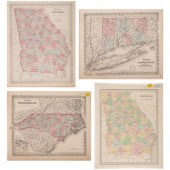 A Group of Three Maps of North
 Carolina, Connecticut and Georgia Published by J.H. Colton, 19th Century together with an additional map of Georgia published by T. G. Bradford; 4 items total. Height of each 16 7/8 x width 13 3/4 inches.
A Group of Three Maps of North
A Group of Three Maps of North Carolina, Connecticut and Georgia Published by J.H. Colton, 19th Century together with an additional map of Georgia published by T. G. Bradford; 4 items total. Height of each 16 7/8 x width 13 3/4 inches. -
 THREE 18TH CENTURY NORTH CAROLINA
 MAPSengravings on laid paper, all unframed, including: John Reid, The State of North Carolina From the Best Authorities , engraver Benjamin Tanner, New York, circa 1796, sheet 16-1/2 x 19 in.; Matthew Carey, North Carolina , engraver William Barker, from Carey's American Pocket Atlas , circa 1796-1801, 6-1/2 x 8-1/2 in.; North Carolina , marked "Lon. W. from Philadelphia", 6-3/4 x 8-1/4 in. Provenance: Humber Family, North Carolina Condition: all with some light toning, especially at edges, some light wear to edges; Reid formerly hinged in, remnants of tape at top
THREE 18TH CENTURY NORTH CAROLINA
THREE 18TH CENTURY NORTH CAROLINA MAPSengravings on laid paper, all unframed, including: John Reid, The State of North Carolina From the Best Authorities , engraver Benjamin Tanner, New York, circa 1796, sheet 16-1/2 x 19 in.; Matthew Carey, North Carolina , engraver William Barker, from Carey's American Pocket Atlas , circa 1796-1801, 6-1/2 x 8-1/2 in.; North Carolina , marked "Lon. W. from Philadelphia", 6-3/4 x 8-1/4 in. Provenance: Humber Family, North Carolina Condition: all with some light toning, especially at edges, some light wear to edges; Reid formerly hinged in, remnants of tape at top -
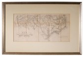
 TWO FRAMED HAND-COLORED PRINTED
 MAPS OF NORTH CAROLINA FRAME: 22 1/2 X 27 1/2 IN. (57.2 X 69.9 CM.)Two Framed Hand-Colored Printed Maps of North Carolina, Dimensions: Frame: 22 1/2 x 27 1/2 in. (57.2 x 69.9 cm.)
TWO FRAMED HAND-COLORED PRINTED
TWO FRAMED HAND-COLORED PRINTED MAPS OF NORTH CAROLINA FRAME: 22 1/2 X 27 1/2 IN. (57.2 X 69.9 CM.)Two Framed Hand-Colored Printed Maps of North Carolina, Dimensions: Frame: 22 1/2 x 27 1/2 in. (57.2 x 69.9 cm.) -
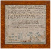 North Carolina sampler, stitched
 "This sampler was wrought in Columbus County by Letsy Ann Young 1842" below a four-line verse and six lines of letters and numbers, lower panel with house and yard with trees, pair of sheep with tails, reclining stag under magnolia tree, floral vine border, silk on linen, 16 x 16-3/4 in. (sight); bird's-eye maple frame. Fading, possible water damage to proper lower left, bleeding of colors especially near sheep and darker stains, losses to silk.
North Carolina sampler, stitched
North Carolina sampler, stitched "This sampler was wrought in Columbus County by Letsy Ann Young 1842" below a four-line verse and six lines of letters and numbers, lower panel with house and yard with trees, pair of sheep with tails, reclining stag under magnolia tree, floral vine border, silk on linen, 16 x 16-3/4 in. (sight); bird's-eye maple frame. Fading, possible water damage to proper lower left, bleeding of colors especially near sheep and darker stains, losses to silk. -
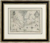
 17th Century Map of the Carolinas
 "A New Description of Carolina", by John Speed, London, 1676, published by Basset and Chiswell, showing the coastline and interior with towns, waterways, and natural landmarks, including several nonexistent geographical features, on laid paper with English text verso, 15 x 20 in. (plate), modern wood frame,
17th Century Map of the Carolinas
17th Century Map of the Carolinas "A New Description of Carolina", by John Speed, London, 1676, published by Basset and Chiswell, showing the coastline and interior with towns, waterways, and natural landmarks, including several nonexistent geographical features, on laid paper with English text verso, 15 x 20 in. (plate), modern wood frame, -
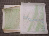 FORTY-FIVE US GEOLOGICAL SURVEY
 MAPS OF VIRGINIA AND NORTH CAROLINA, UNFRAMEDForty-Five US Geological Survey Maps of Virginia and North Carolina, Unframed
FORTY-FIVE US GEOLOGICAL SURVEY
FORTY-FIVE US GEOLOGICAL SURVEY MAPS OF VIRGINIA AND NORTH CAROLINA, UNFRAMEDForty-Five US Geological Survey Maps of Virginia and North Carolina, Unframed -
 RECONSTRUCTION ERA MAP, JOHNSON'S
 NORTH CAROLINA AND SOUTH CAROLINA (New York: Alvin J. Johnson & Co., 1865), steel engraving with subtle color to counties; inset map of Charleston harbor; presented under mat in wooden frame.
RECONSTRUCTION ERA MAP, JOHNSON'S
RECONSTRUCTION ERA MAP, JOHNSON'S NORTH CAROLINA AND SOUTH CAROLINA (New York: Alvin J. Johnson & Co., 1865), steel engraving with subtle color to counties; inset map of Charleston harbor; presented under mat in wooden frame. -
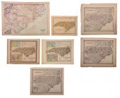 GROUP OF SEVEN 19TH CENTURY NORTH
 CAROLINA MAPSengravings on wove paper with colored highlights, all unframed, including: Asher and Adams, North Carolina and South Carolina , New York, circa 1874; three examples of Joseph Hutchins Colton, North Carolina , New York, circa 1855; Henry Schenck Tanner, A New Map of North Carolina... , Philadelphia, 1841; Thomas Cowperthwait, A New Map of North Carolina... , Philadelphia, 1850; Young and Delleker, North Carolina , published by A. Finley, Philadelphia, circa 1827; largest sheet 17-1/2 x 24-1/2 in. Provenance: Humber Family, North Carolina Condition: some toning, scattered areas of light staining throughout, some wear and small tears to edges; one example of Colton with water damage and tape reinforcement at one side
GROUP OF SEVEN 19TH CENTURY NORTH
GROUP OF SEVEN 19TH CENTURY NORTH CAROLINA MAPSengravings on wove paper with colored highlights, all unframed, including: Asher and Adams, North Carolina and South Carolina , New York, circa 1874; three examples of Joseph Hutchins Colton, North Carolina , New York, circa 1855; Henry Schenck Tanner, A New Map of North Carolina... , Philadelphia, 1841; Thomas Cowperthwait, A New Map of North Carolina... , Philadelphia, 1850; Young and Delleker, North Carolina , published by A. Finley, Philadelphia, circa 1827; largest sheet 17-1/2 x 24-1/2 in. Provenance: Humber Family, North Carolina Condition: some toning, scattered areas of light staining throughout, some wear and small tears to edges; one example of Colton with water damage and tape reinforcement at one side -
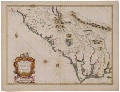 17th Century Map of the Carolinas
 "A New Description of Carolina", by John Speed, published by Basset and Chiswell, London, 1676, showing the coastline and interior with towns, waterways and other natural landmarks, including several nonexistent geographical features, hand-colored engraving on laid paper with fleur de lis watermark, English text verso, 14-13/16 x 19-13/16 in. (plate),
17th Century Map of the Carolinas
17th Century Map of the Carolinas "A New Description of Carolina", by John Speed, published by Basset and Chiswell, London, 1676, showing the coastline and interior with towns, waterways and other natural landmarks, including several nonexistent geographical features, hand-colored engraving on laid paper with fleur de lis watermark, English text verso, 14-13/16 x 19-13/16 in. (plate), -
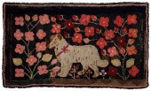 North Carolina hooked rug with dog,
 large white dog with brown markings and red bow collar against a profusion of vines with red, pink and maroon blossoms on a dark brown and green ground, wool on burlap, mounted to a fabric-covered stretcher, fabric backing, American, probably Southern, late 19th century, 45 x 74-1/2 in. Fading, loose and fraying wool, scattered repairs (not examined under backing). Sotheby's, January 23, 1992, lot 832; Nikki and Tom Deupree Antiques, Suffield, Connecticut, 1992
North Carolina hooked rug with dog,
North Carolina hooked rug with dog, large white dog with brown markings and red bow collar against a profusion of vines with red, pink and maroon blossoms on a dark brown and green ground, wool on burlap, mounted to a fabric-covered stretcher, fabric backing, American, probably Southern, late 19th century, 45 x 74-1/2 in. Fading, loose and fraying wool, scattered repairs (not examined under backing). Sotheby's, January 23, 1992, lot 832; Nikki and Tom Deupree Antiques, Suffield, Connecticut, 1992 -
 AN EARLY 19TH CENTURY ENGLISH MAP
 OF THE CAROLINAS (London: Baldwin & Cradock,1833), being North America Sheet XI Parts of North and South Carolina for the Society for the Diffusion of Useful Knowledge. Presented in a wooden frame.
AN EARLY 19TH CENTURY ENGLISH MAP
AN EARLY 19TH CENTURY ENGLISH MAP OF THE CAROLINAS (London: Baldwin & Cradock,1833), being North America Sheet XI Parts of North and South Carolina for the Society for the Diffusion of Useful Knowledge. Presented in a wooden frame. -
 JOHN SPEED - MAP OF THE
 CAROLINAS, 1676John Speed (1551/2-1629), A New Description of Carolina , London, 1676, text in English verso, in Speed's The Theatre of the Empire of Great Britain , engraving on laid paper with hand coloring, plate 15 x 20-1/8 in., sheet 16-3/4 x 21-1/4 in.; carved and gilt wood frame, 25-1/4 x 30-1/2 in. Note: Literature: Cumming, The Southeast in Early Maps , Chapel Hill: University of North Carolina Press, 1998, pg. 166, map 77 Condition: hinged in on mat with archival tape at top edge, some tape residue at sides, light staining, some foxing along lower edge, small tear at top edge near tape; frame with light wear
JOHN SPEED - MAP OF THE
JOHN SPEED - MAP OF THE CAROLINAS, 1676John Speed (1551/2-1629), A New Description of Carolina , London, 1676, text in English verso, in Speed's The Theatre of the Empire of Great Britain , engraving on laid paper with hand coloring, plate 15 x 20-1/8 in., sheet 16-3/4 x 21-1/4 in.; carved and gilt wood frame, 25-1/4 x 30-1/2 in. Note: Literature: Cumming, The Southeast in Early Maps , Chapel Hill: University of North Carolina Press, 1998, pg. 166, map 77 Condition: hinged in on mat with archival tape at top edge, some tape residue at sides, light staining, some foxing along lower edge, small tear at top edge near tape; frame with light wear -
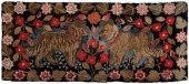 North Carolina hooked rug with
 dogs, two shaggy dogs wearing red collars and facing each other surrounded by a profusion of brightly colored flowers, wool on burlap, mounted to wood stretcher with cotton fabric backing, probably North Carolina, 19th century, 40 x 94 in. Wear, surface losses, areas with loose fabric, fading, some frayed edges, grime (not examined under backing). Sotheby's, January 23, 1992, lot 832; Nikki and Tom Deupree Antiques, Suffield, Connecticut, 1992
North Carolina hooked rug with
North Carolina hooked rug with dogs, two shaggy dogs wearing red collars and facing each other surrounded by a profusion of brightly colored flowers, wool on burlap, mounted to wood stretcher with cotton fabric backing, probably North Carolina, 19th century, 40 x 94 in. Wear, surface losses, areas with loose fabric, fading, some frayed edges, grime (not examined under backing). Sotheby's, January 23, 1992, lot 832; Nikki and Tom Deupree Antiques, Suffield, Connecticut, 1992 -
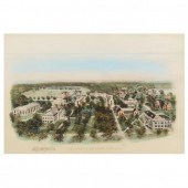 VINTAGE BIRD'S-EYE VIEW OF THE
 UNIVERSITY OF NORTH CAROLINA AT CHAPEL HILL Hand-colored print, early/mid-20th century, with printed details lower margin, matted and framed.
VINTAGE BIRD'S-EYE VIEW OF THE
VINTAGE BIRD'S-EYE VIEW OF THE UNIVERSITY OF NORTH CAROLINA AT CHAPEL HILL Hand-colored print, early/mid-20th century, with printed details lower margin, matted and framed. -
 John White's 16th century map of
 Virginia and North Carolina, "Americae pars, Nunc Virginia dicta, primum ab Anglis inuenta sumtibus Dn. Walteri Raleigh, Equestris ordinis viri Anno Dm. MDLXXXV regm vero Sereniss: nostrae Reginae Elisabethae XXVII. Hujus vero Historia peculiari Libro discripta est, additis etiam Indigenarum Iconibus" by John White, from A Briefe and True Report of the New Founde Land of Virginia , Part 1 of Great Voyages published by Theodore De Bry, Frankfurt, 1590, copper engraving on laid paper with undecipherable watermark, State 2 map with the initial letter "C" imposed onto the letter "E" in "Chesapiooc", plate 11-7/8 x 16-1/4 in., page 13 x 18 in.; modern wood frame. Hinged at top with archival tape and at bottom with Scotch tape, 1 in. strip of top margin restored including most of upper border, reinforced center crease, moderate soiling, fading, toning, creases, minor foxing; frame with abrasions and minor losses, Village Smith Galleries label on backing. Abraham Lincoln Bookstore, Chicago, 1982; Private Collection, Winston-Salem, North Carolina
John White's 16th century map of
John White's 16th century map of Virginia and North Carolina, "Americae pars, Nunc Virginia dicta, primum ab Anglis inuenta sumtibus Dn. Walteri Raleigh, Equestris ordinis viri Anno Dm. MDLXXXV regm vero Sereniss: nostrae Reginae Elisabethae XXVII. Hujus vero Historia peculiari Libro discripta est, additis etiam Indigenarum Iconibus" by John White, from A Briefe and True Report of the New Founde Land of Virginia , Part 1 of Great Voyages published by Theodore De Bry, Frankfurt, 1590, copper engraving on laid paper with undecipherable watermark, State 2 map with the initial letter "C" imposed onto the letter "E" in "Chesapiooc", plate 11-7/8 x 16-1/4 in., page 13 x 18 in.; modern wood frame. Hinged at top with archival tape and at bottom with Scotch tape, 1 in. strip of top margin restored including most of upper border, reinforced center crease, moderate soiling, fading, toning, creases, minor foxing; frame with abrasions and minor losses, Village Smith Galleries label on backing. Abraham Lincoln Bookstore, Chicago, 1982; Private Collection, Winston-Salem, North Carolina -
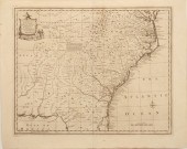
 Three Maps of the Southeastern
 United States American or British, 18th and 19th century: "A New Map of North & South Carolina, & Georgia", by Thomas Kitchin, from the London Magazine, April 1765, showing the Carolinas, Georgia, and portions of Virginia, Louisiana and Florida, on laid paper, 7 x 9-1/8 in. (plate), separated at center crease (in two pieces) with associated losses, text bleed; "North Carolina", by W. Barker, from Matthew Carey's American Pocket Atlas, Philadelphia, 1805, on wove paper, 7-5/8 x 5-3/4 in. (image), foxing; Noua Terrae-Mariae tabula, originally published 1671 by John Ogilby, lithograph reproduction by Weed, Parsons, and Co., Albany, New York, 1865, on onionskin paper, 13-1/2 x 17-1/4 in.; accompanied by atlas text on the region from Complete System of Geography, published by William Innys, et al., London, 1747, (pp. 637-656),
Three Maps of the Southeastern
Three Maps of the Southeastern United States American or British, 18th and 19th century: "A New Map of North & South Carolina, & Georgia", by Thomas Kitchin, from the London Magazine, April 1765, showing the Carolinas, Georgia, and portions of Virginia, Louisiana and Florida, on laid paper, 7 x 9-1/8 in. (plate), separated at center crease (in two pieces) with associated losses, text bleed; "North Carolina", by W. Barker, from Matthew Carey's American Pocket Atlas, Philadelphia, 1805, on wove paper, 7-5/8 x 5-3/4 in. (image), foxing; Noua Terrae-Mariae tabula, originally published 1671 by John Ogilby, lithograph reproduction by Weed, Parsons, and Co., Albany, New York, 1865, on onionskin paper, 13-1/2 x 17-1/4 in.; accompanied by atlas text on the region from Complete System of Geography, published by William Innys, et al., London, 1747, (pp. 637-656), -
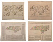 GROUP OF FOUR 19TH CENTURY NORTH
 CAROLINA MAPSfour maps, engravings on wove paper with hand colored highlights, including: Jean Alexandre Buchon, Carte Geographique, Statistique Et Historique De La Caroline Du Nord , Paris, 1825, unframed; Matthew Carey, North Carolina from the Latest Surveys by Samuel Lewis , Philadelphia, circa 1804-1815, unframed; Matthew Carey, North Carolina , Philadelphia, circa 1814, unframed; H.C. Carey and Isaac Lea, Geographical, Statistical, and Historical Map of North Carolina , Philadelphia, circa 1822, matted not framed; largest sheet 17-3/4 x 22 in. Provenance: Humber Family, North Carolina Condition: all with some toning and light staining throughout; H.C. Carey map with some light foxing, hinged in on mat
GROUP OF FOUR 19TH CENTURY NORTH
GROUP OF FOUR 19TH CENTURY NORTH CAROLINA MAPSfour maps, engravings on wove paper with hand colored highlights, including: Jean Alexandre Buchon, Carte Geographique, Statistique Et Historique De La Caroline Du Nord , Paris, 1825, unframed; Matthew Carey, North Carolina from the Latest Surveys by Samuel Lewis , Philadelphia, circa 1804-1815, unframed; Matthew Carey, North Carolina , Philadelphia, circa 1814, unframed; H.C. Carey and Isaac Lea, Geographical, Statistical, and Historical Map of North Carolina , Philadelphia, circa 1822, matted not framed; largest sheet 17-3/4 x 22 in. Provenance: Humber Family, North Carolina Condition: all with some toning and light staining throughout; H.C. Carey map with some light foxing, hinged in on mat -
 SIX 19TH CENTURY MAPS OF NORTH
 AND SOUTH CAROLINAsix maps, engravings on wove paper, some with hand colored highlights, all unframed, including: three examples of Frank Gray, Gray's New Map of North and South Carolina , Philadelphia, circa 1881; Johnson and Ward, Johnson's North and South Carolina , New York, circa 1862, from Johnson's New and Illustrated Family Atlas ; T.G. Bradford, North Carolina, South Carolina, and Georgia , Boston, circa 1835; map of North and South Carolina and several pages from View of the United States, Historical, Geographical, and Statistical... by William Darby, Philadelphia: H.S. Tanner, 1828; largest sheet 18 x 26-3/4 in. Provenance: Humber Family, North Carolina Condition: all with some toning, scattered wear and small tears to edges, some handling creases; one example of Gray's map separated and taped together along front of join line, several tears at edges; one example of Gray's map laid down on board; Bradford map with some foxing
SIX 19TH CENTURY MAPS OF NORTH
SIX 19TH CENTURY MAPS OF NORTH AND SOUTH CAROLINAsix maps, engravings on wove paper, some with hand colored highlights, all unframed, including: three examples of Frank Gray, Gray's New Map of North and South Carolina , Philadelphia, circa 1881; Johnson and Ward, Johnson's North and South Carolina , New York, circa 1862, from Johnson's New and Illustrated Family Atlas ; T.G. Bradford, North Carolina, South Carolina, and Georgia , Boston, circa 1835; map of North and South Carolina and several pages from View of the United States, Historical, Geographical, and Statistical... by William Darby, Philadelphia: H.S. Tanner, 1828; largest sheet 18 x 26-3/4 in. Provenance: Humber Family, North Carolina Condition: all with some toning, scattered wear and small tears to edges, some handling creases; one example of Gray's map separated and taped together along front of join line, several tears at edges; one example of Gray's map laid down on board; Bradford map with some foxing -
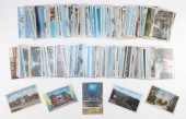 (VIEW) NORTH CAROLINA (90) AND
 SOUTH CAROLINA (65): 155 POSTCARDS MID- TO LATE 20TH CENTURY(VIEW) NORTH CAROLINA (90) AND SOUTH CAROLINA (65): 155 POSTCARDS, Mid- to Late 20th Century, North Carolina: Mile High and Swinging Bridge, panning for rubies, interior of a tobacco leaf warehouse, Hotel Charles (Selby), Women's College (U of NC) and more. South Carolina: The Ottarry Hotel, Furman University Building, Anderson College, Fort Sumter Hotel, Oregon Hotel and more.
(VIEW) NORTH CAROLINA (90) AND
(VIEW) NORTH CAROLINA (90) AND SOUTH CAROLINA (65): 155 POSTCARDS MID- TO LATE 20TH CENTURY(VIEW) NORTH CAROLINA (90) AND SOUTH CAROLINA (65): 155 POSTCARDS, Mid- to Late 20th Century, North Carolina: Mile High and Swinging Bridge, panning for rubies, interior of a tobacco leaf warehouse, Hotel Charles (Selby), Women's College (U of NC) and more. South Carolina: The Ottarry Hotel, Furman University Building, Anderson College, Fort Sumter Hotel, Oregon Hotel and more. -
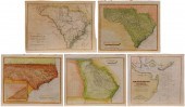 Five 19th Century Southeastern Maps
 American and German, three by Samuel Lewis: "North Carolina", engraved by Tanner, Boston, 1804, 8-3/4 x 10-3/8 in. (page); "Georgia", engraved by D. Fairman, Philadelphia, 1808, 8-3/4 x 10-3/8 in. (page); "South Carolina", engraved by D. Fairman, Philadelphia, 1812, 8-3/4 x 10-3/8 in. (page); "Sud Carolina, Nach des Gouverneurs von Carolina", after 1803 map by J. Drayton, Weimar, Germany, 1808, 9-1/2 x 11-7/8 in. (page); "Charleston Harbour", by E. Blunt, New York, 1833, 9-1/8 x 9-3/4 in. (page), all unframed, hand colored on laid or wove paper, (five pieces),
Five 19th Century Southeastern Maps
Five 19th Century Southeastern Maps American and German, three by Samuel Lewis: "North Carolina", engraved by Tanner, Boston, 1804, 8-3/4 x 10-3/8 in. (page); "Georgia", engraved by D. Fairman, Philadelphia, 1808, 8-3/4 x 10-3/8 in. (page); "South Carolina", engraved by D. Fairman, Philadelphia, 1812, 8-3/4 x 10-3/8 in. (page); "Sud Carolina, Nach des Gouverneurs von Carolina", after 1803 map by J. Drayton, Weimar, Germany, 1808, 9-1/2 x 11-7/8 in. (page); "Charleston Harbour", by E. Blunt, New York, 1833, 9-1/8 x 9-3/4 in. (page), all unframed, hand colored on laid or wove paper, (five pieces), -
 John Wilson's map of South Carolina
 Wilson John. A MAP OF SOUTH CAROLINA. Philadelphia: H. Tanner 1822. In four parts each hand-colored and matted all encased within custom clamshell box accompanied by an essay on its historical importance by John Long. Provenance: Columbia South Carolina private collection. From the University of South Carolina Libraries Special Collections Department sold to benefit the aquisitions fund. All sheets with various degrees of toning age discoloration foxing worn edges and small tears or losses along edges (with the upper left map providing the worst example); all with archival tape on verso top edges; bottom two maps with a few small professionally mended tears visible on verso.
John Wilson's map of South Carolina
John Wilson's map of South Carolina Wilson John. A MAP OF SOUTH CAROLINA. Philadelphia: H. Tanner 1822. In four parts each hand-colored and matted all encased within custom clamshell box accompanied by an essay on its historical importance by John Long. Provenance: Columbia South Carolina private collection. From the University of South Carolina Libraries Special Collections Department sold to benefit the aquisitions fund. All sheets with various degrees of toning age discoloration foxing worn edges and small tears or losses along edges (with the upper left map providing the worst example); all with archival tape on verso top edges; bottom two maps with a few small professionally mended tears visible on verso.
...many more examples with full details are available to our members - Learn more
Easy & Visual methods to Identify & Appraise Antiques & Collectibles
EASY. FAST. ACCURATE.
Research at its best
We are here to help!
Our research tools include:

Thousands of makers marks for PORCELAIN, POTTERY CHINAWARE, FIGURINES, VASES
see details...

Thousands of marks & hallmarks for SILVER & JEWELRY, PEWTER, PRECIOUS METALS, SILVERPLATE
see details...
