Pricing Guides & Dictionary of Makers Marks for Antiques & Collectibles
A few examples of appraisal values for
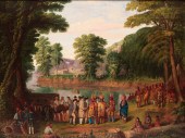
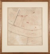
ORIGINAL LANDING AMERICAN FORCES
Search our price guide for your own treasures
-
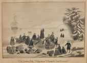 AMERICAN SCHOOL , THE LANDING OF
 THE PILGRIMSAmerican SchoolThe landing of the pilgrims on Plymouth Rockwatercolor on papersigned indistinctly lower right and dated Feb 1854 lower left9 1/2 x 13 1/4in (24 x 33.5cm) Provenance: Time: May 2024 Place: ANDREW JONES AUCTIONS, Los Angeles, CA, USA Sold for: $200 Imported successfully Replaced successfully Error: unknown error
AMERICAN SCHOOL , THE LANDING OF
AMERICAN SCHOOL , THE LANDING OF THE PILGRIMSAmerican SchoolThe landing of the pilgrims on Plymouth Rockwatercolor on papersigned indistinctly lower right and dated Feb 1854 lower left9 1/2 x 13 1/4in (24 x 33.5cm) Provenance: Time: May 2024 Place: ANDREW JONES AUCTIONS, Los Angeles, CA, USA Sold for: $200 Imported successfully Replaced successfully Error: unknown error -
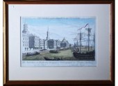 18th/19th century handcolored
 engraving by Francois Xavier, Germany, titled in German and French "Landing of British Troops at New York." Image 11.5” x 16.25” Custom frame 19” x 23.75” Condition: not examined out of frame, stains and toning to paper CT Transfer Fee $20
18th/19th century handcolored
18th/19th century handcolored engraving by Francois Xavier, Germany, titled in German and French "Landing of British Troops at New York." Image 11.5” x 16.25” Custom frame 19” x 23.75” Condition: not examined out of frame, stains and toning to paper CT Transfer Fee $20 -
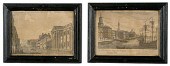 Early French-American Engravings
 French-American 18th century. ?A pair of early engravings first titled Bank of the United States with a View of Third Street in Philadelphia along lower margin and second titled Debarquement des Troupes engloises a nouvelle Yorck (roughly translates to "Landing of British Troops in New York"); 5.75 x 9 to 6 x 9.5 in. Condition: Toning and loss of paper.
Early French-American Engravings
Early French-American Engravings French-American 18th century. ?A pair of early engravings first titled Bank of the United States with a View of Third Street in Philadelphia along lower margin and second titled Debarquement des Troupes engloises a nouvelle Yorck (roughly translates to "Landing of British Troops in New York"); 5.75 x 9 to 6 x 9.5 in. Condition: Toning and loss of paper. -
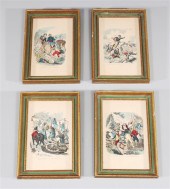 Group of four antique framed hand
 colored engravings of the American Revolution, including: Knocx Entering Camp with Artillery; Washington Endevouring to Rally the Fugitives; Countrymen Joing the Army Under Gates; Washington and Lee at Monmouth; overall good condtion, minor surface wear, minor age wear; including frame L 7" W 10 1/4" (Approx.)Provenance: Private Collection, Palos Verdes Estates, California
Group of four antique framed hand
Group of four antique framed hand colored engravings of the American Revolution, including: Knocx Entering Camp with Artillery; Washington Endevouring to Rally the Fugitives; Countrymen Joing the Army Under Gates; Washington and Lee at Monmouth; overall good condtion, minor surface wear, minor age wear; including frame L 7" W 10 1/4" (Approx.)Provenance: Private Collection, Palos Verdes Estates, California -
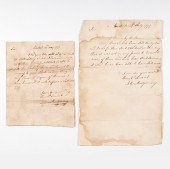
 1675 AMERICAN COLONIAL LAND
 GRANTDated 55 years after the Pilgrims landed. Handwritten, listing many early Pre Revolutionary War 17th C. Connecticut settlers. Document has been reinforced with two Connecticut Civil War Bonds, somewhat visible through the back of the document. Appr ox. 12-1/4" L x 15-3/8" H. Overall discoloration, tears, ECT. See images for more details on condition. This item can be shipped in-house.
1675 AMERICAN COLONIAL LAND
1675 AMERICAN COLONIAL LAND GRANTDated 55 years after the Pilgrims landed. Handwritten, listing many early Pre Revolutionary War 17th C. Connecticut settlers. Document has been reinforced with two Connecticut Civil War Bonds, somewhat visible through the back of the document. Appr ox. 12-1/4" L x 15-3/8" H. Overall discoloration, tears, ECT. See images for more details on condition. This item can be shipped in-house. -
 LANDING OF THE PIONEERS BY SALA
 BOSWORTH. Massachusetts/Ohio, 1808-1889. Oil on canvas, unsigned. The landing of the original forty eight settlers of Marietta led by Rufus Putnam on April 7, 1788. They are shown with local Native Americans on the east bank of the Muskingum River with Ft. Harmar in the background and the confluence of the Ohio River on the left. Pictured on the bank is the "Adventure Galley", one of two flatboats which brought the settlers. Areas of inpainting, primarily along lines of crazing and flaking along the sky and the trees on the right as well as some scattered areas along the river and the figures. Rebacked on canvas over board and varnished. Frame is most likely original with regilding. 23"h. 29"w., framed, 30"h. 37"w. Sala Bosworth moved with his family to Marietta, Ohio in 1818, afterwards becoming an artist, known primarily as a portrait painter. He and Charles Sullivan were commissioned to illustrate Dr. Samuel P. Hildreth's 1848 book "Pioneer History of the Ohio Valley". At that time Dr. Hildreth commissioned this painting from Bosworth. Since then it has descended in the Hildreth and Putnam families as follows: Commissioned by Dr. Samuel P. Hildreth (1783-1863), then to his daughter, Mary Ann Hildreth (1808-1842) who married Douglas Putnam (1806-1894), then to their son, Samuel Hildreth Putnam (1835-1911), then to his son, Benjamin Barnes Putnam (1871-1944), and to his son, Benjamin Hay Putnam (1896-1984), and then to Benjamin Hay Putnam, Jr. (1925-2007). One of Bosworth's murals remains in the Unitarian Church in Marietta, titled "Christ Weeping over Jerusalem".
LANDING OF THE PIONEERS BY SALA
LANDING OF THE PIONEERS BY SALA BOSWORTH. Massachusetts/Ohio, 1808-1889. Oil on canvas, unsigned. The landing of the original forty eight settlers of Marietta led by Rufus Putnam on April 7, 1788. They are shown with local Native Americans on the east bank of the Muskingum River with Ft. Harmar in the background and the confluence of the Ohio River on the left. Pictured on the bank is the "Adventure Galley", one of two flatboats which brought the settlers. Areas of inpainting, primarily along lines of crazing and flaking along the sky and the trees on the right as well as some scattered areas along the river and the figures. Rebacked on canvas over board and varnished. Frame is most likely original with regilding. 23"h. 29"w., framed, 30"h. 37"w. Sala Bosworth moved with his family to Marietta, Ohio in 1818, afterwards becoming an artist, known primarily as a portrait painter. He and Charles Sullivan were commissioned to illustrate Dr. Samuel P. Hildreth's 1848 book "Pioneer History of the Ohio Valley". At that time Dr. Hildreth commissioned this painting from Bosworth. Since then it has descended in the Hildreth and Putnam families as follows: Commissioned by Dr. Samuel P. Hildreth (1783-1863), then to his daughter, Mary Ann Hildreth (1808-1842) who married Douglas Putnam (1806-1894), then to their son, Samuel Hildreth Putnam (1835-1911), then to his son, Benjamin Barnes Putnam (1871-1944), and to his son, Benjamin Hay Putnam (1896-1984), and then to Benjamin Hay Putnam, Jr. (1925-2007). One of Bosworth's murals remains in the Unitarian Church in Marietta, titled "Christ Weeping over Jerusalem". -
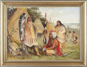 American School (19th c.) Plains
 Indian Groupoil on canvas (lined) unsigned depicting a chief with horned war bonnet addressing a woman and man before an encampment with decorated tipi presented in a later frame.SS 23 x 31.25 in.; DOA 29 x 37 in.Cut and laid down; several repaired tears; obscuring varnish.Private Collection
American School (19th c.) Plains
American School (19th c.) Plains Indian Groupoil on canvas (lined) unsigned depicting a chief with horned war bonnet addressing a woman and man before an encampment with decorated tipi presented in a later frame.SS 23 x 31.25 in.; DOA 29 x 37 in.Cut and laid down; several repaired tears; obscuring varnish.Private Collection -
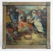
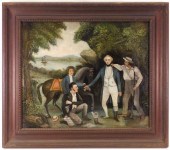 EARLY CAPTURE OF MAJOR ANDRE
 COLONIAL PAINTING United States,Circa 1800Early colonial historical depiction of the Capture of Major Andre, Andre is shown without a shoe surrounded by men in a forest. Major Andre was part of the British army and head of their Secret Service in America during the American Revolutionary War. He was later hung as a spy for assisting Benedict Arnold's attempted surrender of West Point.
EARLY CAPTURE OF MAJOR ANDRE
EARLY CAPTURE OF MAJOR ANDRE COLONIAL PAINTING United States,Circa 1800Early colonial historical depiction of the Capture of Major Andre, Andre is shown without a shoe surrounded by men in a forest. Major Andre was part of the British army and head of their Secret Service in America during the American Revolutionary War. He was later hung as a spy for assisting Benedict Arnold's attempted surrender of West Point. -
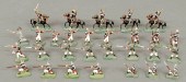 Twenty-nine painted cast lead
 miniature soldiers some in American Revolutionary attire.
Twenty-nine painted cast lead
Twenty-nine painted cast lead miniature soldiers some in American Revolutionary attire. -
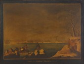
 American School, 19th century
 moonlit landing of two ships with figures, campfire and dog Unsigned, oil on board, framed. H: 18 in. W: 22 in. (overall) PROVENANCE: Mrs. Betty Anderson, Wenonah, New Jersey. ,000 grimey, stretcher nails scuffed painting at edge, board slightly warped
American School, 19th century
American School, 19th century moonlit landing of two ships with figures, campfire and dog Unsigned, oil on board, framed. H: 18 in. W: 22 in. (overall) PROVENANCE: Mrs. Betty Anderson, Wenonah, New Jersey. ,000 grimey, stretcher nails scuffed painting at edge, board slightly warped -
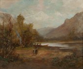 Native American river encampment
 oil on canvas. 22'' H x 26'' W.
Native American river encampment
Native American river encampment oil on canvas. 22'' H x 26'' W. -
 Early 20th c. oil on canvas
 pilgrims and native Americans gathering. Sight 25 3/4'' x 36''.
Early 20th c. oil on canvas
Early 20th c. oil on canvas pilgrims and native Americans gathering. Sight 25 3/4'' x 36''. -
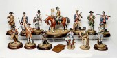 13 FIGURE ROYAL DOULTON SOLDIERS OF
 THE AMERICAN REVOLUTION: The first American soldiers from the original 13 states. Bicentennial Commemorative issue limited to 350 sets, and produced in association with the Colonial Williamsburg Foundation. Largest Approx. 16'' h. CONDITION: Chip to base of the private of the 4th Connecticut regiment. Wear consistent with age and use.
13 FIGURE ROYAL DOULTON SOLDIERS OF
13 FIGURE ROYAL DOULTON SOLDIERS OF THE AMERICAN REVOLUTION: The first American soldiers from the original 13 states. Bicentennial Commemorative issue limited to 350 sets, and produced in association with the Colonial Williamsburg Foundation. Largest Approx. 16'' h. CONDITION: Chip to base of the private of the 4th Connecticut regiment. Wear consistent with age and use. -
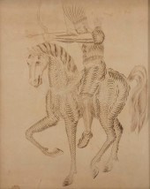 AMERICAN SCHOOL, NATIVE AMERICAN
 WARRIORAmerican School(18th century)Native American warrior on horsebackpen and ink on paper19 3/4 x 15 1/2in (50 x 39cm)
AMERICAN SCHOOL, NATIVE AMERICAN
AMERICAN SCHOOL, NATIVE AMERICAN WARRIORAmerican School(18th century)Native American warrior on horsebackpen and ink on paper19 3/4 x 15 1/2in (50 x 39cm) -
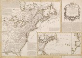 FIRST EDITION OF RARE REVOLUTIONARY
 WAR MAP"Carte Nouvelle des Possessions Angloises en Amérique dressée pour l'intellegence de la guerre, Paris 1777, Maurille Antoine Moithey, engineer". Translation: New map of the English possessions in America created for the war intelligence, Paris...". Detailed historical, topographical and military notes outlining the British Colonies and neighboring regions. The map includes a large inset map depicting the Pacific French trade routes to the new world from Europe. English Forts and settlements are detailed. Measuring, 19 1/4" x 27 1/4". In very good condition, archival framing. We can provide high resolution photos.
FIRST EDITION OF RARE REVOLUTIONARY
FIRST EDITION OF RARE REVOLUTIONARY WAR MAP"Carte Nouvelle des Possessions Angloises en Amérique dressée pour l'intellegence de la guerre, Paris 1777, Maurille Antoine Moithey, engineer". Translation: New map of the English possessions in America created for the war intelligence, Paris...". Detailed historical, topographical and military notes outlining the British Colonies and neighboring regions. The map includes a large inset map depicting the Pacific French trade routes to the new world from Europe. English Forts and settlements are detailed. Measuring, 19 1/4" x 27 1/4". In very good condition, archival framing. We can provide high resolution photos. -
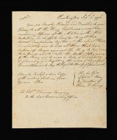
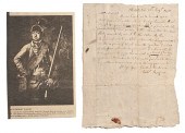 Robert Rogers Colonial Frontiersman
 ANS 1778 Robert Rogers (1731-1795). Colonial frontiersman and soldier who fought for the British in the French & Indian Wars and the American Revolution; founder and commander of Rogers' Rangers a highly effective militia in the French & Indian Wars which produced several important leaders in the Continental Army who fought against their former commander. ANS 1p on laid paper 8.25 x 6.5 in. August 20 1778 at Middleton addressed to William Arnold Inn Holder of Greenwich (RI) asking him to retrieve clothing and wafers from a box stored in the inn's cave and to forward the items to Mr. Gideon Mumford who will deliver them. Condition: Scattered stains and soiling with minor holes along the folds.
Robert Rogers Colonial Frontiersman
Robert Rogers Colonial Frontiersman ANS 1778 Robert Rogers (1731-1795). Colonial frontiersman and soldier who fought for the British in the French & Indian Wars and the American Revolution; founder and commander of Rogers' Rangers a highly effective militia in the French & Indian Wars which produced several important leaders in the Continental Army who fought against their former commander. ANS 1p on laid paper 8.25 x 6.5 in. August 20 1778 at Middleton addressed to William Arnold Inn Holder of Greenwich (RI) asking him to retrieve clothing and wafers from a box stored in the inn's cave and to forward the items to Mr. Gideon Mumford who will deliver them. Condition: Scattered stains and soiling with minor holes along the folds. -
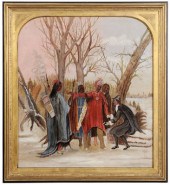
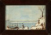 AMERICAN SCHOOL (19TH CENTURY,),
 PRIMITIVE SCENE WITH A NATIVE AMERICAN GREETING SETTLERS AS THEY LAND ON SHORE., WATERCOLOR, 9.5" X 15.25" SIGHT. FRAMED 13.25" X 19.25".AMERICAN SCHOOL, 19th Century, Primitive scene with a Native American greeting settlers as they land on shore. Unsigned. Dimensions: Watercolor, 9.5" x 15.25" sight. Framed 13.25" x 19.25".
AMERICAN SCHOOL (19TH CENTURY,),
AMERICAN SCHOOL (19TH CENTURY,), PRIMITIVE SCENE WITH A NATIVE AMERICAN GREETING SETTLERS AS THEY LAND ON SHORE., WATERCOLOR, 9.5" X 15.25" SIGHT. FRAMED 13.25" X 19.25".AMERICAN SCHOOL, 19th Century, Primitive scene with a Native American greeting settlers as they land on shore. Unsigned. Dimensions: Watercolor, 9.5" x 15.25" sight. Framed 13.25" x 19.25". -
 [BATTLE OF NEW ORLEANS
 MAP][Battle of New Orleans Map] , "Plan of an Attack made by the British Forces on the American Lines in Advance of Orleans on the 8th January 1815", engraved map, hand-colored in blue and red, ND but c. 1815, 15 1/2 in. x 14 1/4 in., matted and framed Provenance: Collection of Brooke and Maria Fox, Metairie, LA
[BATTLE OF NEW ORLEANS
[BATTLE OF NEW ORLEANS MAP][Battle of New Orleans Map] , "Plan of an Attack made by the British Forces on the American Lines in Advance of Orleans on the 8th January 1815", engraved map, hand-colored in blue and red, ND but c. 1815, 15 1/2 in. x 14 1/4 in., matted and framed Provenance: Collection of Brooke and Maria Fox, Metairie, LA -
 [Native Americans] Group of 14
 titles including: Eastman The Soul of the Indian; and Lois Lenski Indian Captive: The Story of Mary Jemison Estimate $ 100-150
[Native Americans] Group of 14
[Native Americans] Group of 14 titles including: Eastman The Soul of the Indian; and Lois Lenski Indian Captive: The Story of Mary Jemison Estimate $ 100-150 -
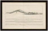 Revolutionary map, Sullivan's
 Island, "A N. bE. View of the Fort on the Western End of Sulivans [sic] Island with the Disposition of His Majesty's Fleet Commanded by Commodore Sir Peter Parker…during the Attack on the 28th of June 1776…" by William Faden (1750-1836), London, 1776, showing panoramic view of Sullivan's Island with fortifications and legend detailing various points of interest in the battle, copper engraving on laid paper with watermark, page 12-1/8 x 19-1/2 in.; modern wood frame. Loose, toning, minor foxing, fading, creases, stains, minor losses and tears in margins, repaired loss on left side affecting plate, center crease reinforced, archival tape verso, later pencil inscriptions; frame with abrasions. Deaccessioned from MESDA and Old Salem to benefit the Acquisition Fund.
Revolutionary map, Sullivan's
Revolutionary map, Sullivan's Island, "A N. bE. View of the Fort on the Western End of Sulivans [sic] Island with the Disposition of His Majesty's Fleet Commanded by Commodore Sir Peter Parker…during the Attack on the 28th of June 1776…" by William Faden (1750-1836), London, 1776, showing panoramic view of Sullivan's Island with fortifications and legend detailing various points of interest in the battle, copper engraving on laid paper with watermark, page 12-1/8 x 19-1/2 in.; modern wood frame. Loose, toning, minor foxing, fading, creases, stains, minor losses and tears in margins, repaired loss on left side affecting plate, center crease reinforced, archival tape verso, later pencil inscriptions; frame with abrasions. Deaccessioned from MESDA and Old Salem to benefit the Acquisition Fund. -
 AMERICAN PRE REVOLUTIONARY WAR LAND
 DEED United States,1773Land deed to a Mr. Stephen Burllingame from a Mr. Stephen Collins.
AMERICAN PRE REVOLUTIONARY WAR LAND
AMERICAN PRE REVOLUTIONARY WAR LAND DEED United States,1773Land deed to a Mr. Stephen Burllingame from a Mr. Stephen Collins. -
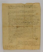
 1 piece. (American Revolution.)
 Manuscript Document. (Howe, General William.) Huntington [Long Island, New York], Sept. 2, 1776. 1 p., 4to; minor spotting. Contemporary true copy of General Howe's orders, just after The Battle of Long Island, to Colonel Phineas Fanning, signed & otherwise in the hand of Oliver D. Lancey, commander of a regiment of Loyalist New Yorkers in The Battle of Long Island. Howe orders Fanning to direct, "... all The King's Captains [etc.]... to call their several companies together... to order them that have taken arms against The King to lay down their arms and to take the Oath of Allegiance to The King and to... [reject] the orders of Congress...." ,000-6,000Unsold
1 piece. (American Revolution.)
1 piece. (American Revolution.) Manuscript Document. (Howe, General William.) Huntington [Long Island, New York], Sept. 2, 1776. 1 p., 4to; minor spotting. Contemporary true copy of General Howe's orders, just after The Battle of Long Island, to Colonel Phineas Fanning, signed & otherwise in the hand of Oliver D. Lancey, commander of a regiment of Loyalist New Yorkers in The Battle of Long Island. Howe orders Fanning to direct, "... all The King's Captains [etc.]... to call their several companies together... to order them that have taken arms against The King to lay down their arms and to take the Oath of Allegiance to The King and to... [reject] the orders of Congress...." ,000-6,000Unsold -
 American School (19th century),
 "Roger Williams Greeting the Indians at Narragansett Bay", unsigned, after A. H. Wray, oil on canvas, "1958.375" verso stretcher, 18-1/2 x 16-1/4 in., original gilt wood spandrel with black-painted lattice frame,
American School (19th century),
American School (19th century), "Roger Williams Greeting the Indians at Narragansett Bay", unsigned, after A. H. Wray, oil on canvas, "1958.375" verso stretcher, 18-1/2 x 16-1/4 in., original gilt wood spandrel with black-painted lattice frame, -
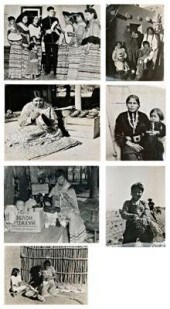 110 vintage photos, Native
 Americans: mostly southwestern tribes, some Seminole, including one of Howard Tiger, first Seminole Marine Corps volunteer, most identified, with imprints of Office of Indian Affairs, names of photographers verso, one by Rothstein (possibly Arthur Rothstein), most dated early 1940's, 50 are about 8 x 10 in., others range down to 3-1/4 x 4-1/4 in. Folds, creases, toning throughout. Private Collection, Salisbury, North Carolina
110 vintage photos, Native
110 vintage photos, Native Americans: mostly southwestern tribes, some Seminole, including one of Howard Tiger, first Seminole Marine Corps volunteer, most identified, with imprints of Office of Indian Affairs, names of photographers verso, one by Rothstein (possibly Arthur Rothstein), most dated early 1940's, 50 are about 8 x 10 in., others range down to 3-1/4 x 4-1/4 in. Folds, creases, toning throughout. Private Collection, Salisbury, North Carolina -
 Naive American Landscape Oil on
 Canvas Early 20th century. A naive American landscape with Indians in canoes unsigned; 8 x 10.5 in.
Naive American Landscape Oil on
Naive American Landscape Oil on Canvas Early 20th century. A naive American landscape with Indians in canoes unsigned; 8 x 10.5 in. -
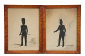 PAIR WAR OF 1812 MILITARY
 SILHOUETTES - Period Full-Length Silhouette Portraits of American and British Infantry Officers with watercolor backgrounds the American has a West Point building to the right in mitered birdseye maple frames under old glass
PAIR WAR OF 1812 MILITARY
PAIR WAR OF 1812 MILITARY SILHOUETTES - Period Full-Length Silhouette Portraits of American and British Infantry Officers with watercolor backgrounds the American has a West Point building to the right in mitered birdseye maple frames under old glass -
 John Montgomery Early American
 Soldier & Settler ANsS Lot of 2.John Montgomery (c.1750-1794).? American pioneer of the Cumberland Gap and Tennessee and Revolutionary War soldier.? Two ANsS dated May 14 1777 and July 27 1777 at Carlisle regarding distribution of lottery tickets. Condition: Water damage edge wear and partial separation at the folds.
John Montgomery Early American
John Montgomery Early American Soldier & Settler ANsS Lot of 2.John Montgomery (c.1750-1794).? American pioneer of the Cumberland Gap and Tennessee and Revolutionary War soldier.? Two ANsS dated May 14 1777 and July 27 1777 at Carlisle regarding distribution of lottery tickets. Condition: Water damage edge wear and partial separation at the folds. -
 * (AMERICANA MILITARY) A group of
 five works. Fighting the Flying Circus. By Capt. Edward V. Rickenbacker. New York: Frederick A. Stokes (1919). D-Day with the Screaming Eagles. By George E. Koskimaki. New York: Vantage Press (1970). Viet Journal. By James Jones. New York: Delacourte (1974). History of United States Naval Operations: Korea. By James A. Field. Washington: s.n. 1962. Yank: The Army Weekly Aug. 17 1945 Vol. 4 No. 9.
* (AMERICANA MILITARY) A group of
* (AMERICANA MILITARY) A group of five works. Fighting the Flying Circus. By Capt. Edward V. Rickenbacker. New York: Frederick A. Stokes (1919). D-Day with the Screaming Eagles. By George E. Koskimaki. New York: Vantage Press (1970). Viet Journal. By James Jones. New York: Delacourte (1974). History of United States Naval Operations: Korea. By James A. Field. Washington: s.n. 1962. Yank: The Army Weekly Aug. 17 1945 Vol. 4 No. 9. -
 MANNER OF MICHELE FELICE CORNE.
 Landing at Plymouth. Oil on canvas laid to board. Inscriptions to bottom of board read "Landing of our forefathers at Plymouth, December 22, 1620". Verso reads "F.C. HUNT". From a Norwalk, CT estate. Dimensions: 21" h x 23" w. Condition: Craquelure. Minor scuffs and scratches. Dark Varnish difficult to determine earlier restoration.
MANNER OF MICHELE FELICE CORNE.
MANNER OF MICHELE FELICE CORNE. Landing at Plymouth. Oil on canvas laid to board. Inscriptions to bottom of board read "Landing of our forefathers at Plymouth, December 22, 1620". Verso reads "F.C. HUNT". From a Norwalk, CT estate. Dimensions: 21" h x 23" w. Condition: Craquelure. Minor scuffs and scratches. Dark Varnish difficult to determine earlier restoration. -
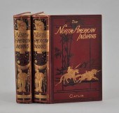 North American Indians Being
 Letters and Notes on Their Manners, Customs, and Conditions, Written During Eight Years' Travel Amongst the Wildest Tribes of Indians in North America, 1832-1839 Philadelphia: Leary, Stuart and Company, 1913. Two vol, cloth with embossed covers and printed in black and gold. 320 illustrations, carefully engraved from the author's original paintings. Fold out map. Deckled edges and GTE. 8 vo.
North American Indians Being
North American Indians Being Letters and Notes on Their Manners, Customs, and Conditions, Written During Eight Years' Travel Amongst the Wildest Tribes of Indians in North America, 1832-1839 Philadelphia: Leary, Stuart and Company, 1913. Two vol, cloth with embossed covers and printed in black and gold. 320 illustrations, carefully engraved from the author's original paintings. Fold out map. Deckled edges and GTE. 8 vo. -
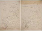 American Indian Wars Campaign
 Maps American, late 19th century, two copies of "Sioux Campaign, Winter 1890-91. Maj. Gen. Nelson A. Miles, U.S.A. Commanding. Map No. 1. To Illustrate the Recent Campaign against Hostile Sioux Indians of Dakota", probably published by the U.S. Army, circa 1891, showing Standing Rock, Cheyenne River, Rosebud and Pine Ridge Indian reservations, with U.S. Army troops and "Hostile Indians" positions noted, crossed swords icon labeled "Affair at Wounded Knee, Dec. 29, 1890" marks the location of the Wounded Knee Massacre, Indian agencies, transportation routes, waterways and topographical features also noted, with some hand color, 35-7/8 x 23-7/8 in. (page),
American Indian Wars Campaign
American Indian Wars Campaign Maps American, late 19th century, two copies of "Sioux Campaign, Winter 1890-91. Maj. Gen. Nelson A. Miles, U.S.A. Commanding. Map No. 1. To Illustrate the Recent Campaign against Hostile Sioux Indians of Dakota", probably published by the U.S. Army, circa 1891, showing Standing Rock, Cheyenne River, Rosebud and Pine Ridge Indian reservations, with U.S. Army troops and "Hostile Indians" positions noted, crossed swords icon labeled "Affair at Wounded Knee, Dec. 29, 1890" marks the location of the Wounded Knee Massacre, Indian agencies, transportation routes, waterways and topographical features also noted, with some hand color, 35-7/8 x 23-7/8 in. (page), -
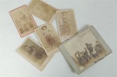 SIX PHOTOGRAPHS OF AMERICAN
 INDIANS. Includes a photograph of a dance identified on verso as the Fourth of July dance at the Fort Belknap Reservation. Together with five cartes de visite including a portrait of Scar-Faced Bear of the Warm Spring Tribe Ashland Kentucky 1886 a portrait of the son of Chief American-Horse Ashland a portrait of the 'half-breed gymnast' Red-Leaves also likely made in Ashland and two unidentified portraits.
SIX PHOTOGRAPHS OF AMERICAN
SIX PHOTOGRAPHS OF AMERICAN INDIANS. Includes a photograph of a dance identified on verso as the Fourth of July dance at the Fort Belknap Reservation. Together with five cartes de visite including a portrait of Scar-Faced Bear of the Warm Spring Tribe Ashland Kentucky 1886 a portrait of the son of Chief American-Horse Ashland a portrait of the 'half-breed gymnast' Red-Leaves also likely made in Ashland and two unidentified portraits. -
 REVOLUTIONARY WAR-ERA MAP OF
 AMERICA. Carte Nouvelle de l'Amerique Angloise. Augsbourg: Matthieu Albert Lotter 1776. Handcolored engraving on laid paper. Imperfections. 23 1/2''h. 19 1/4''w. (sight) matted and framed 28 1/2''h. 24 1/4''w. Some foxing and toning marginal damage/losses fold lines.
REVOLUTIONARY WAR-ERA MAP OF
REVOLUTIONARY WAR-ERA MAP OF AMERICA. Carte Nouvelle de l'Amerique Angloise. Augsbourg: Matthieu Albert Lotter 1776. Handcolored engraving on laid paper. Imperfections. 23 1/2''h. 19 1/4''w. (sight) matted and framed 28 1/2''h. 24 1/4''w. Some foxing and toning marginal damage/losses fold lines. -
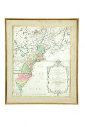
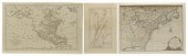 Three early U.S. maps: "A Plan of
 the Country from Frogs Point to Croton River Showing the Positions of the American and British Armies from the 12th of October 1776 Until the Engagement on the White Plains on the 28th", from The Life of George Washington: Maps and Subscribers Names , published circa 1807 by C.P. Wayne, map by Samuel Lewis, on laid paper, page 18 x 11-1/2 in., hinged at top with archival tape, center crease with sealed separations and losses, sealed separation at bottom margin, losses to page (not affecting map), stains ; "A New & Accurate Map of North America; Drawn from the most Authentic Modern Maps and Charts by Thos. Bowen", engraved for "Middleton's Complete System of Geography" by Charles Theodore Milton, published circa 1780, London, page 11-3/4 x 18-1/4 in., old folds and creases, pencil inscriptions upper right, water stain at right margin ; "A New Map of North America from the Latest Discoveries, 1761", by John Spilsbury, "Engraved for the Continuation of Dr. Smollett's History of England", page 11-3/4 x 15-3/4 in., later coloring, hinged at top, 3/4 in. taped tear at right margin, uneven margins, pencil inscriptions verso, loss to page at lower right (not affecting map), smudges . All with toning and foxing. The Estate of the Late Dr. Jeffrey Lieberman
Three early U.S. maps: "A Plan of
Three early U.S. maps: "A Plan of the Country from Frogs Point to Croton River Showing the Positions of the American and British Armies from the 12th of October 1776 Until the Engagement on the White Plains on the 28th", from The Life of George Washington: Maps and Subscribers Names , published circa 1807 by C.P. Wayne, map by Samuel Lewis, on laid paper, page 18 x 11-1/2 in., hinged at top with archival tape, center crease with sealed separations and losses, sealed separation at bottom margin, losses to page (not affecting map), stains ; "A New & Accurate Map of North America; Drawn from the most Authentic Modern Maps and Charts by Thos. Bowen", engraved for "Middleton's Complete System of Geography" by Charles Theodore Milton, published circa 1780, London, page 11-3/4 x 18-1/4 in., old folds and creases, pencil inscriptions upper right, water stain at right margin ; "A New Map of North America from the Latest Discoveries, 1761", by John Spilsbury, "Engraved for the Continuation of Dr. Smollett's History of England", page 11-3/4 x 15-3/4 in., later coloring, hinged at top, 3/4 in. taped tear at right margin, uneven margins, pencil inscriptions verso, loss to page at lower right (not affecting map), smudges . All with toning and foxing. The Estate of the Late Dr. Jeffrey Lieberman -
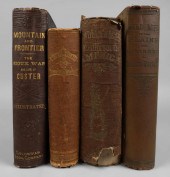 HISTORY OF NATIVE AMERICAN
 WARFARE AND AMERICAN ENCOUNTERSHISTORY OF NATIVE AMERICAN WARFARE AND AMERICAN ENCOUNTERS, [Native Americans and the West] 4 titles, all 8vo of varying sizes: W.L Holloway etc. Wild Life on the Plains and Horrors of Indian Warfare. St. Louis: The Excelsior Publishing Co; Frances Victor, Eleven Years in the Rocky Mountains and Life on the Frontier. Hartford: Columbian Book Company. 1879. Engravings and maps; George Belden. The White Chief; or, Twelve Years Among the Wild Indians of the Plains. Cincinnati/NY: C.F. Vent. 1871; Charles De Wolf Brownell. The Indian Races of North and South America... Hartford: American Publishing Company. 1865 (4)
HISTORY OF NATIVE AMERICAN
HISTORY OF NATIVE AMERICAN WARFARE AND AMERICAN ENCOUNTERSHISTORY OF NATIVE AMERICAN WARFARE AND AMERICAN ENCOUNTERS, [Native Americans and the West] 4 titles, all 8vo of varying sizes: W.L Holloway etc. Wild Life on the Plains and Horrors of Indian Warfare. St. Louis: The Excelsior Publishing Co; Frances Victor, Eleven Years in the Rocky Mountains and Life on the Frontier. Hartford: Columbian Book Company. 1879. Engravings and maps; George Belden. The White Chief; or, Twelve Years Among the Wild Indians of the Plains. Cincinnati/NY: C.F. Vent. 1871; Charles De Wolf Brownell. The Indian Races of North and South America... Hartford: American Publishing Company. 1865 (4) -
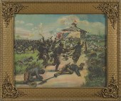 [Late Indian Wars] Charge of the
 Colored Troops Lithograph American titled Charge of the Colored Troops - San Juan in lower margin dated 1907 and published by James Lee Co. Chicago l.l.; 15.5 x 19.5 in. Condition: Toning.
[Late Indian Wars] Charge of the
[Late Indian Wars] Charge of the Colored Troops Lithograph American titled Charge of the Colored Troops - San Juan in lower margin dated 1907 and published by James Lee Co. Chicago l.l.; 15.5 x 19.5 in. Condition: Toning.
...many more examples with full details are available to our members - Learn more
Easy & Visual methods to Identify & Appraise Antiques & Collectibles
EASY. FAST. ACCURATE.
Research at its best
We are here to help!
Our research tools include:

Thousands of makers marks for PORCELAIN, POTTERY CHINAWARE, FIGURINES, VASES
see details...

Thousands of marks & hallmarks for SILVER & JEWELRY, PEWTER, PRECIOUS METALS, SILVERPLATE
see details...
