Pricing Guides & Dictionary of Makers Marks for Antiques & Collectibles
A few examples of appraisal values for
RAND MCNALLY
Search our price guide for your own treasures
-
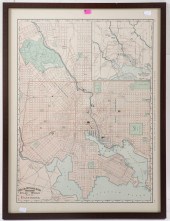
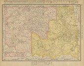
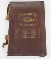 RAND MCNALLY & CO. ENLARGED
 BUSINESS ATLAS Illinois,1881"Rand McNally & Co.'s Enlarged Business Atlas and Shippers' Guide" published by Rand, McNally & Company 1881.
RAND MCNALLY & CO. ENLARGED
RAND MCNALLY & CO. ENLARGED BUSINESS ATLAS Illinois,1881"Rand McNally & Co.'s Enlarged Business Atlas and Shippers' Guide" published by Rand, McNally & Company 1881. -
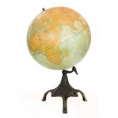
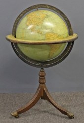
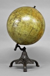
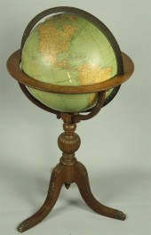
 RAND MCNALLY & CO. TERRESTRIAL
 GLOBE ON STAND Rand McNally & Co. (American, founded 1856), circa 1920. Terrestrial 18" globe on parcel ebonized walnut art deco stand. Note: This globe shows the name of St. Petersburg, Russia as Petrograd. The city held this name from September 1, 1914 until
RAND MCNALLY & CO. TERRESTRIAL
RAND MCNALLY & CO. TERRESTRIAL GLOBE ON STAND Rand McNally & Co. (American, founded 1856), circa 1920. Terrestrial 18" globe on parcel ebonized walnut art deco stand. Note: This globe shows the name of St. Petersburg, Russia as Petrograd. The city held this name from September 1, 1914 until -
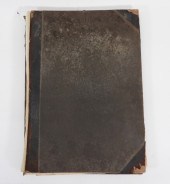 1894 RAND MCNALLY & CO ATLAS OF THE
 WORLD United States,1894"Rand, McNally & Co.'s Atlas of the World" published by Rand, McNally & Company in 1894.
1894 RAND MCNALLY & CO ATLAS OF THE
1894 RAND MCNALLY & CO ATLAS OF THE WORLD United States,1894"Rand, McNally & Co.'s Atlas of the World" published by Rand, McNally & Company in 1894. -
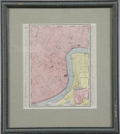 Rand, McNally and Company Colored
 Map, of "The Main Portion of New Orleans", 1895, sight 13" x 11". Glazed and presented in a pale sage green mat within a verdigris-finished reeded wooden frame.
Rand, McNally and Company Colored
Rand, McNally and Company Colored Map, of "The Main Portion of New Orleans", 1895, sight 13" x 11". Glazed and presented in a pale sage green mat within a verdigris-finished reeded wooden frame. -
 1891 RAND, MCNALLY & CO. MAP OF
 BALTIMORE 28 1/2 x 21 1/4 in., framed.
1891 RAND, MCNALLY & CO. MAP OF
1891 RAND, MCNALLY & CO. MAP OF BALTIMORE 28 1/2 x 21 1/4 in., framed. -
 4PC CRAM & RAND MCNALLY WORLD
 ATLASES ,1883-1900Includes "Cram's Unrivaled Family Atlas of the World" published by George F. Cram circa. 1900, "Cram's Unrivaled Family Atlas of the World" copyright 1883 by George F. Cram, "Cram's Unrivaled Atlas of the World" published by Henry S. Stebbins in 1888, and "The Rand- McNally Standard Atlas of the World" published by The Continental Publishing Co. in 1888.
4PC CRAM & RAND MCNALLY WORLD
4PC CRAM & RAND MCNALLY WORLD ATLASES ,1883-1900Includes "Cram's Unrivaled Family Atlas of the World" published by George F. Cram circa. 1900, "Cram's Unrivaled Family Atlas of the World" copyright 1883 by George F. Cram, "Cram's Unrivaled Atlas of the World" published by Henry S. Stebbins in 1888, and "The Rand- McNally Standard Atlas of the World" published by The Continental Publishing Co. in 1888. -
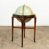
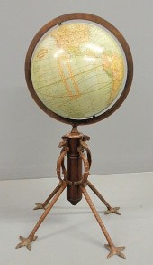
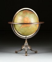
 A RAND MCNALLY AND COMPANY 18"
 TERRESTRIAL GLOBE A Rand McNally and Company 18" Terrestrial globe, the whole rising on a swivel and rotating patinated support, 28"h
A RAND MCNALLY AND COMPANY 18"
A RAND MCNALLY AND COMPANY 18" TERRESTRIAL GLOBE A Rand McNally and Company 18" Terrestrial globe, the whole rising on a swivel and rotating patinated support, 28"h -
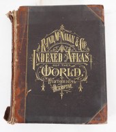 RAND MCNALLY & CO. INDEXED ATLAS OF
 THE WORLD Illinois,1881"Rand, McNally & Co.'s Indexed Atlas of the World Historical and Descriptive" by Rand, McNally & Co. in 1881.
RAND MCNALLY & CO. INDEXED ATLAS OF
RAND MCNALLY & CO. INDEXED ATLAS OF THE WORLD Illinois,1881"Rand, McNally & Co.'s Indexed Atlas of the World Historical and Descriptive" by Rand, McNally & Co. in 1881. -
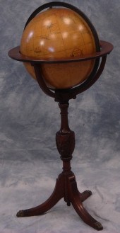
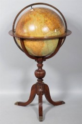
 Rand McNally & Co. Victorian
 globe with a brass ring and mahogany shaft the legs with griffin heads and claw feet. 31"h.
Rand McNally & Co. Victorian
Rand McNally & Co. Victorian globe with a brass ring and mahogany shaft the legs with griffin heads and claw feet. 31"h. -
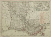 RAND, MCNALLY & CO ATLAS MAP
 LOUISIANA RAILROADSFramed engraving on paper, map of Louisiana railroads, from "New Business Atlas Map of Louisiana," published by Rand, McNally & Co., copyright 1898, railroad network overprinted in red, with inset vicinity of New Orleans, vertical fold crease, sight: 19.75"h, 26.75"w, overall: 28.25"h, 35.25"w, 10.25lbs
RAND, MCNALLY & CO ATLAS MAP
RAND, MCNALLY & CO ATLAS MAP LOUISIANA RAILROADSFramed engraving on paper, map of Louisiana railroads, from "New Business Atlas Map of Louisiana," published by Rand, McNally & Co., copyright 1898, railroad network overprinted in red, with inset vicinity of New Orleans, vertical fold crease, sight: 19.75"h, 26.75"w, overall: 28.25"h, 35.25"w, 10.25lbs -
 Rand McNally & Company
 terrestrial globe, 18", 40"h x 23"dia, as found CONDITION: railing broken in one spot (see photos), date unknown, legs in good condition
Rand McNally & Company
Rand McNally & Company terrestrial globe, 18", 40"h x 23"dia, as found CONDITION: railing broken in one spot (see photos), date unknown, legs in good condition -
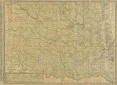
 AN ANTIQUE MAP, "RAND MCNALLY &
 CO.'S NEW BUSINESS ATLA...AN ANTIQUE MAP, "Rand McNally & Co.'s New Business Atlas Map of Indian Territory and Oklahoma," CIRCA 1903, color engraving on paper, showing chief cities, populations, and numbered railroad lines, pages 306 and 307 of original atlas. 19 3/4" x 26 3/4" Provenance: Property from a Fortune 500 Energy Company, Houston, Texas. Condition: A crease at center as issued, expected mild surface wear, but overall in very good condition, wear commensurate with age. Simpson Galleries strongly encourages in-person inspection of items by the bidder. Statements by Simpson Galleries regarding the condition of objects are for guidance only and should not be relied upon as statements of fact and do not constitute a representation, warranty, or assumption of liability by Simpson Galleries. All lots offered are sold "AS IS."
AN ANTIQUE MAP, "RAND MCNALLY &
AN ANTIQUE MAP, "RAND MCNALLY & CO.'S NEW BUSINESS ATLA...AN ANTIQUE MAP, "Rand McNally & Co.'s New Business Atlas Map of Indian Territory and Oklahoma," CIRCA 1903, color engraving on paper, showing chief cities, populations, and numbered railroad lines, pages 306 and 307 of original atlas. 19 3/4" x 26 3/4" Provenance: Property from a Fortune 500 Energy Company, Houston, Texas. Condition: A crease at center as issued, expected mild surface wear, but overall in very good condition, wear commensurate with age. Simpson Galleries strongly encourages in-person inspection of items by the bidder. Statements by Simpson Galleries regarding the condition of objects are for guidance only and should not be relied upon as statements of fact and do not constitute a representation, warranty, or assumption of liability by Simpson Galleries. All lots offered are sold "AS IS." -
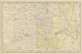
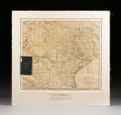
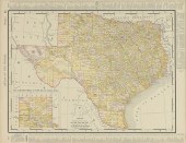
 AN ANTIQUE MAP, "RAND MCNALLY &
 CO.'S TEXAS," CHICAGO, ...AN ANTIQUE MAP, "Rand McNally & Co.'s Texas," CHICAGO, CIRCA 1892, color engraving on paper, a page fragment from Rand McNally's New Business Atlas, pages 254-255, showing approximately 40 railroad lines, major waterways, geological formations, counties, cities, and Indian territories. 20" x 26 1/2" Provenance: Property from a Fortune 500 Energy Company, Houston, Texas. Condition: Some yellowing at seam, joined papers, but overall in very good condition, wear commensurate with age. Simpson Galleries strongly encourages in-person inspection of items by the bidder. Statements by Simpson Galleries regarding the condition of objects are for guidance only and should not be relied upon as statements of fact and do not constitute a representation, warranty, or assumption of liability by Simpson Galleries. All lots offered are sold "AS IS."
AN ANTIQUE MAP, "RAND MCNALLY &
AN ANTIQUE MAP, "RAND MCNALLY & CO.'S TEXAS," CHICAGO, ...AN ANTIQUE MAP, "Rand McNally & Co.'s Texas," CHICAGO, CIRCA 1892, color engraving on paper, a page fragment from Rand McNally's New Business Atlas, pages 254-255, showing approximately 40 railroad lines, major waterways, geological formations, counties, cities, and Indian territories. 20" x 26 1/2" Provenance: Property from a Fortune 500 Energy Company, Houston, Texas. Condition: Some yellowing at seam, joined papers, but overall in very good condition, wear commensurate with age. Simpson Galleries strongly encourages in-person inspection of items by the bidder. Statements by Simpson Galleries regarding the condition of objects are for guidance only and should not be relied upon as statements of fact and do not constitute a representation, warranty, or assumption of liability by Simpson Galleries. All lots offered are sold "AS IS." -
 Early printed globe of the world on
 a cast iron stand signed 'Rand McNally Twelve Inch, Terrestrial Globe, Chicago' 20"H
Early printed globe of the world on
Early printed globe of the world on a cast iron stand signed 'Rand McNally Twelve Inch, Terrestrial Globe, Chicago' 20"H -
 THE RAND MCNALLY & CO.'S
 TERRESTRIAL GLOBE, 18", USA, 1...THE RAND McNALLY & CO.'S TERRESTRIAL GLOBE, 18", USA, 1916-1924, the plaster globe covered with twelve color lithographed paper gores and under the Aleutian Islands area an oval label titled "RAND McNALLY & CO'S. / NEW / EIGHTEEN INCH / TERRESTRIAL / GLOBE," and in South Pacific Ocean above Antarctic is printed "Rand, 'McNally & Co.' a New Eighteen Inch Terrestrial Globe. / Copyright, 1894, by Rand, 'McNally & Co. / 'Revised, 1916," with equatorial divided by degrees in both directions, meridian Greenwich details, an analemma (table of equation of time); oceans, seas, gulfs, bays, channels, canals, and major rivers, lakes, and contemporary ocean currents; land masses of continents, islands, etc, with demarcation lines of nations, republics, empires, territories, and colonial titled nations, British India, French Indochina, etc; with sub states, provinces, prefectures, and cities, towns, some lesser populated villages; geographical details including mountains, deserts, plains, rivers, lakes, coastlines, etc; with some man made entities including the Great Wall of China, or the submarine telegraph lines; with engraved brass meridian circle, printed paper covered wood horizon ring with compass directions, divided by houses of Zodiac with symbols, months, and respective number of days; mounted on a cast iron "C" form support with knob stem and raised on a copper plated cast iron tripod base modeled with scrolling leafy tendrils centering monogram cartouches of "RMcN&COs," alternating three foliate detailed monopodia topped by demi-globe cabochons with latitude/longitude lines and ending in bird talons clutching globe spheres with matching lines. Height: 33" Diameter: 26" Condition: Globe has small worn spots, dings, scratches, some gore edges slightly lifting, surface varnish has darkened, one hole towards bottom of globe; meridian brass circle has oxidized areas, buildup, and slight wear; horizon ring has wear, losses, old marks, scratches, and surface buildup in areas; cast iron support has light surface rust in areas; tripod base has small surface oxidized spots throughout and small scratches from use. Simpson Galleries strongly encourages in-person inspection of items by the bidder. Statements by Simpson Galleries regarding the condition of objects are for guidance only and should not be relied upon as statements of fact and do not constitute a representation, warranty, or assumption of liability by Simpson Galleries. All lots offered are sold "AS IS.”
THE RAND MCNALLY & CO.'S
THE RAND MCNALLY & CO.'S TERRESTRIAL GLOBE, 18", USA, 1...THE RAND McNALLY & CO.'S TERRESTRIAL GLOBE, 18", USA, 1916-1924, the plaster globe covered with twelve color lithographed paper gores and under the Aleutian Islands area an oval label titled "RAND McNALLY & CO'S. / NEW / EIGHTEEN INCH / TERRESTRIAL / GLOBE," and in South Pacific Ocean above Antarctic is printed "Rand, 'McNally & Co.' a New Eighteen Inch Terrestrial Globe. / Copyright, 1894, by Rand, 'McNally & Co. / 'Revised, 1916," with equatorial divided by degrees in both directions, meridian Greenwich details, an analemma (table of equation of time); oceans, seas, gulfs, bays, channels, canals, and major rivers, lakes, and contemporary ocean currents; land masses of continents, islands, etc, with demarcation lines of nations, republics, empires, territories, and colonial titled nations, British India, French Indochina, etc; with sub states, provinces, prefectures, and cities, towns, some lesser populated villages; geographical details including mountains, deserts, plains, rivers, lakes, coastlines, etc; with some man made entities including the Great Wall of China, or the submarine telegraph lines; with engraved brass meridian circle, printed paper covered wood horizon ring with compass directions, divided by houses of Zodiac with symbols, months, and respective number of days; mounted on a cast iron "C" form support with knob stem and raised on a copper plated cast iron tripod base modeled with scrolling leafy tendrils centering monogram cartouches of "RMcN&COs," alternating three foliate detailed monopodia topped by demi-globe cabochons with latitude/longitude lines and ending in bird talons clutching globe spheres with matching lines. Height: 33" Diameter: 26" Condition: Globe has small worn spots, dings, scratches, some gore edges slightly lifting, surface varnish has darkened, one hole towards bottom of globe; meridian brass circle has oxidized areas, buildup, and slight wear; horizon ring has wear, losses, old marks, scratches, and surface buildup in areas; cast iron support has light surface rust in areas; tripod base has small surface oxidized spots throughout and small scratches from use. Simpson Galleries strongly encourages in-person inspection of items by the bidder. Statements by Simpson Galleries regarding the condition of objects are for guidance only and should not be relied upon as statements of fact and do not constitute a representation, warranty, or assumption of liability by Simpson Galleries. All lots offered are sold "AS IS.” -
 AN ANTIQUE MAP, "RAND MCNALLY & CO.
 NEW BUSINESS ATLAS ...AN ANTIQUE MAP, "Rand McNally & Co. New Business Atlas Map of Indian Territory & Oklahoma," CHICAGO, CIRCA 1892, color engraving on paper, with view of Beaver County, a page fragment from Indexed Atlas of the World, page 411. 13 1/4" x 20" Provenance: Property from a Fortune 500 Energy Company, Houston, Texas. Condition: Mild fading and yellow tone, but overall in very good condition, wear commensurate with age. Simpson Galleries strongly encourages in-person inspection of items by the bidder. Statements by Simpson Galleries regarding the condition of objects are for guidance only and should not be relied upon as statements of fact and do not constitute a representation, warranty, or assumption of liability by Simpson Galleries. All lots offered are sold "AS IS."
AN ANTIQUE MAP, "RAND MCNALLY & CO.
AN ANTIQUE MAP, "RAND MCNALLY & CO. NEW BUSINESS ATLAS ...AN ANTIQUE MAP, "Rand McNally & Co. New Business Atlas Map of Indian Territory & Oklahoma," CHICAGO, CIRCA 1892, color engraving on paper, with view of Beaver County, a page fragment from Indexed Atlas of the World, page 411. 13 1/4" x 20" Provenance: Property from a Fortune 500 Energy Company, Houston, Texas. Condition: Mild fading and yellow tone, but overall in very good condition, wear commensurate with age. Simpson Galleries strongly encourages in-person inspection of items by the bidder. Statements by Simpson Galleries regarding the condition of objects are for guidance only and should not be relied upon as statements of fact and do not constitute a representation, warranty, or assumption of liability by Simpson Galleries. All lots offered are sold "AS IS." -
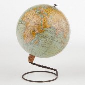
 Terrestrial globe on mahogany
 base by Rand McNally, mid-20th c Estimate $100-200
Terrestrial globe on mahogany
Terrestrial globe on mahogany base by Rand McNally, mid-20th c Estimate $100-200 -
 RAND MCNALLY'S 1892 1ST MARKETED
 SCHOOL EARTH GLOBERand McNally & Co., USA. The first 6-inch terrestial globe marketed by Rand McNally & Co. for schools in 1892. Marked under the South Pacific Ocean "Rand McNally & Co.'s New Six Inch Terrestial Globe," and "Copyright, 1892, by Rand McNally & Co." With base; height: 8 1/2 in x diameter: 6 in. Condition: Please contact us for a detailed condition report. Please note that the lack of a condition statement does not imply perfect condition. Email condition@revereauctions.com with any condition questions.
RAND MCNALLY'S 1892 1ST MARKETED
RAND MCNALLY'S 1892 1ST MARKETED SCHOOL EARTH GLOBERand McNally & Co., USA. The first 6-inch terrestial globe marketed by Rand McNally & Co. for schools in 1892. Marked under the South Pacific Ocean "Rand McNally & Co.'s New Six Inch Terrestial Globe," and "Copyright, 1892, by Rand McNally & Co." With base; height: 8 1/2 in x diameter: 6 in. Condition: Please contact us for a detailed condition report. Please note that the lack of a condition statement does not imply perfect condition. Email condition@revereauctions.com with any condition questions. -
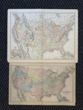 TWO UNFRAMED MAPS OF THE UNITED
 STATES, RAND MCNALLY AND J.H. COLSTON, LARGER: 21 3/4 X 28 IN. (55.25 X 71.12 CM.)Two Unframed Maps of the United States, Rand McNally and J.H. Colston,, Dimensions: Larger: 21 3/4 x 28 in. (55.25 x 71.12 cm.)
TWO UNFRAMED MAPS OF THE UNITED
TWO UNFRAMED MAPS OF THE UNITED STATES, RAND MCNALLY AND J.H. COLSTON, LARGER: 21 3/4 X 28 IN. (55.25 X 71.12 CM.)Two Unframed Maps of the United States, Rand McNally and J.H. Colston,, Dimensions: Larger: 21 3/4 x 28 in. (55.25 x 71.12 cm.) -
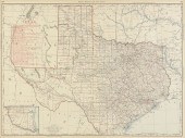
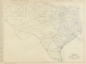
 AN ANTIQUE MAP, "RAND MCNALLY &
 CO.'S NEW ENLARGED SCAL...AN ANTIQUE MAP, "Rand McNally & Co.'s New Enlarged Scale Railroad and County Map of Texas, Showing Every Railroad Station and Post Office in the State," CHICAGO, CIRCA 1885, color cerography on paper, with hand painted and inscribed railroad chart, which is also color coded: Santa Fe Railroad, blue; H&TC (Houston & Texas Central Railroad), orange; Gould Railroad, blue; narrow gauge railroad, white; and South Pacific, green, "Copyright 1885 by Rand McNally and Co., Chicago, Ill.," an inset view of an untitled "El Paso," upper left, and in the lower left an inset view of the, "N.W. Corner and Panhandle," accompanied by a blue woven fabric covered and gilt embossed, "Rand McNally & Co's New Enlarged Scale Indexed Railroad and County Map of Texas," pocketbook, which appears to retain most original pages, now bound and mounted together with map in an excellently preserved historical presentation. 26 3/4" x 30 1/4" Provenance: Property from a Corporate Collection, Houston, Texas. Property from a Corporate Collection, Houston, Texas Condition: Some mild fading hand color, mostly white, creases as issued, also handling creases, some buckling, a tear upper left, mild yellowing. The pocket book has a tear at spine and an old paper label affixed. Overall in good to very condition, wear commensurate with age. Would benefit tremendously from remounting and stabilizing backing to preserve integrity of the entirety of the presentation. Simpson Galleries strongly encourages in-person inspection of items by the bidder. Statements by Simpson Galleries regarding the condition of objects are for guidance only and should not be relied upon as statements of fact and do not constitute a representation, warranty, or assumption of liability by Simpson Galleries. All lots offered are sold "AS IS.” NO REFUNDS will be issued based on condition.
AN ANTIQUE MAP, "RAND MCNALLY &
AN ANTIQUE MAP, "RAND MCNALLY & CO.'S NEW ENLARGED SCAL...AN ANTIQUE MAP, "Rand McNally & Co.'s New Enlarged Scale Railroad and County Map of Texas, Showing Every Railroad Station and Post Office in the State," CHICAGO, CIRCA 1885, color cerography on paper, with hand painted and inscribed railroad chart, which is also color coded: Santa Fe Railroad, blue; H&TC (Houston & Texas Central Railroad), orange; Gould Railroad, blue; narrow gauge railroad, white; and South Pacific, green, "Copyright 1885 by Rand McNally and Co., Chicago, Ill.," an inset view of an untitled "El Paso," upper left, and in the lower left an inset view of the, "N.W. Corner and Panhandle," accompanied by a blue woven fabric covered and gilt embossed, "Rand McNally & Co's New Enlarged Scale Indexed Railroad and County Map of Texas," pocketbook, which appears to retain most original pages, now bound and mounted together with map in an excellently preserved historical presentation. 26 3/4" x 30 1/4" Provenance: Property from a Corporate Collection, Houston, Texas. Property from a Corporate Collection, Houston, Texas Condition: Some mild fading hand color, mostly white, creases as issued, also handling creases, some buckling, a tear upper left, mild yellowing. The pocket book has a tear at spine and an old paper label affixed. Overall in good to very condition, wear commensurate with age. Would benefit tremendously from remounting and stabilizing backing to preserve integrity of the entirety of the presentation. Simpson Galleries strongly encourages in-person inspection of items by the bidder. Statements by Simpson Galleries regarding the condition of objects are for guidance only and should not be relied upon as statements of fact and do not constitute a representation, warranty, or assumption of liability by Simpson Galleries. All lots offered are sold "AS IS.” NO REFUNDS will be issued based on condition. -
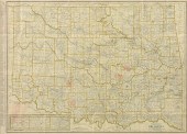
 AN ANTIQUE MAP, "RAND MCNALLY
 STANDARD MAP OF OKLAHOMA,...AN ANTIQUE MAP, "Rand McNally Standard Map of Oklahoma," CHICAGO, EARLY 20TH CENTURY, color engraving on paper, with view of "Western Portion of Oklahoma," showing principal cities and Oklahoma Railroads. 19 1/2" x 27" Provenance: Property from a Fortune 500 Energy Company, Houston, Texas. Condition: Some creases, a tear at lower left, but overall in good condition, wear commensurate with age. Simpson Galleries strongly encourages in-person inspection of items by the bidder. Statements by Simpson Galleries regarding the condition of objects are for guidance only and should not be relied upon as statements of fact and do not constitute a representation, warranty, or assumption of liability by Simpson Galleries. All lots offered are sold "AS IS."
AN ANTIQUE MAP, "RAND MCNALLY
AN ANTIQUE MAP, "RAND MCNALLY STANDARD MAP OF OKLAHOMA,...AN ANTIQUE MAP, "Rand McNally Standard Map of Oklahoma," CHICAGO, EARLY 20TH CENTURY, color engraving on paper, with view of "Western Portion of Oklahoma," showing principal cities and Oklahoma Railroads. 19 1/2" x 27" Provenance: Property from a Fortune 500 Energy Company, Houston, Texas. Condition: Some creases, a tear at lower left, but overall in good condition, wear commensurate with age. Simpson Galleries strongly encourages in-person inspection of items by the bidder. Statements by Simpson Galleries regarding the condition of objects are for guidance only and should not be relied upon as statements of fact and do not constitute a representation, warranty, or assumption of liability by Simpson Galleries. All lots offered are sold "AS IS." -
 AN ANTIQUE MAP, "RAND MCNALLY &
 CO.'S NEW 11" X 14" MAP...AN ANTIQUE MAP, "Rand McNally & Co.'s New 11" x 14" Map of Texas," CHICAGO, CIRCA 1895, color engraving on paper, with view of "The Panhandle of Texas, on same Scale," the border listing population, counties, chief cities, a page fragment from Atlas of the World. 11" x 14" Note: The map showing a divided Oklahoma and "Indian Territory," to the north, railroad lines, topography, cities and towns. Provenance: Property from a Fortune 500 Energy Company, Houston, Texas. Condition: Mild expected wear, but overall in very good condition, wear commensurate with age. Simpson Galleries strongly encourages in-person inspection of items by the bidder. Statements by Simpson Galleries regarding the condition of objects are for guidance only and should not be relied upon as statements of fact and do not constitute a representation, warranty, or assumption of liability by Simpson Galleries. All lots offered are sold "AS IS."
AN ANTIQUE MAP, "RAND MCNALLY &
AN ANTIQUE MAP, "RAND MCNALLY & CO.'S NEW 11" X 14" MAP...AN ANTIQUE MAP, "Rand McNally & Co.'s New 11" x 14" Map of Texas," CHICAGO, CIRCA 1895, color engraving on paper, with view of "The Panhandle of Texas, on same Scale," the border listing population, counties, chief cities, a page fragment from Atlas of the World. 11" x 14" Note: The map showing a divided Oklahoma and "Indian Territory," to the north, railroad lines, topography, cities and towns. Provenance: Property from a Fortune 500 Energy Company, Houston, Texas. Condition: Mild expected wear, but overall in very good condition, wear commensurate with age. Simpson Galleries strongly encourages in-person inspection of items by the bidder. Statements by Simpson Galleries regarding the condition of objects are for guidance only and should not be relied upon as statements of fact and do not constitute a representation, warranty, or assumption of liability by Simpson Galleries. All lots offered are sold "AS IS." -
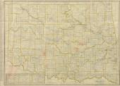
 AN ANTIQUE MAP, "RAND MCNALLY
 STANDARD MAP OF OKLAHOMA,...AN ANTIQUE MAP, "Rand McNally Standard Map of Oklahoma," color ink engraving on paper, with four unusual hand drawn concentric circles over remote areas including the Keechi Hills. 19 1/2" x 26 3/4" Note: A gold rush in the early 20th century enticed thousands of prospectors to enter into Native territories of Oklahoma. This lure of gold combined with a deep history of renegade bandit occupation of this area in the late 19th century by infamous criminals such as Jesse James, perpetuates the myth of buried treasure and unknown wealth hidden somewhere in Oklahoma. Purportedly stashed east of Cache Creek by Jesse James and his gang after an 1876 robbery; the treasure remains yet to be discovered well into the 21st century. The four areas circled by hand appear over the Keechi Hills, over Little Beaver Creek and Cow Creek, the areas between Wewoka Creek and Little River, and finally an over the Canadian River between Little Wewoka Creek and Alabama Creek. Provenance: Property from a Fortune 500 Energy Company, Houston, Texas. Condition: Some creases as issued, mild toning, added four red concentric circles appear in remote areas with no indication what their purpose is, expected toning and surface wear, but overall in very good condition, wear commensurate with age and use. Simpson Galleries strongly encourages in-person inspection of items by the bidder. Statements by Simpson Galleries regarding the condition of objects are for guidance only and should not be relied upon as statements of fact and do not constitute a representation, warranty, or assumption of liability by Simpson Galleries. All lots offered are sold "AS IS."
AN ANTIQUE MAP, "RAND MCNALLY
AN ANTIQUE MAP, "RAND MCNALLY STANDARD MAP OF OKLAHOMA,...AN ANTIQUE MAP, "Rand McNally Standard Map of Oklahoma," color ink engraving on paper, with four unusual hand drawn concentric circles over remote areas including the Keechi Hills. 19 1/2" x 26 3/4" Note: A gold rush in the early 20th century enticed thousands of prospectors to enter into Native territories of Oklahoma. This lure of gold combined with a deep history of renegade bandit occupation of this area in the late 19th century by infamous criminals such as Jesse James, perpetuates the myth of buried treasure and unknown wealth hidden somewhere in Oklahoma. Purportedly stashed east of Cache Creek by Jesse James and his gang after an 1876 robbery; the treasure remains yet to be discovered well into the 21st century. The four areas circled by hand appear over the Keechi Hills, over Little Beaver Creek and Cow Creek, the areas between Wewoka Creek and Little River, and finally an over the Canadian River between Little Wewoka Creek and Alabama Creek. Provenance: Property from a Fortune 500 Energy Company, Houston, Texas. Condition: Some creases as issued, mild toning, added four red concentric circles appear in remote areas with no indication what their purpose is, expected toning and surface wear, but overall in very good condition, wear commensurate with age and use. Simpson Galleries strongly encourages in-person inspection of items by the bidder. Statements by Simpson Galleries regarding the condition of objects are for guidance only and should not be relied upon as statements of fact and do not constitute a representation, warranty, or assumption of liability by Simpson Galleries. All lots offered are sold "AS IS." -
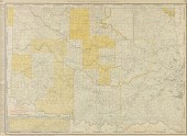
 AN ANTIQUE MAP, "RAND MCNALLY &
 CO.'S NEW 11" X 14" MAP...AN ANTIQUE MAP, "Rand McNally & Co.'s New 11" x 14" Map of Indian Territory and Oklahoma," CHICAGO, CIRCA 1895, color engraving on paper, showing the "Western portion of Oklahoma," the border listing population, counties, Nations and reservations, and chief cities for Oklahoma, opposed by population, nations and chief cities for the Indian Territory, a page fragment from Atlas of the World. 11" x 14" Provenance: Property from a Fortune 500 Energy Company, Houston, Texas. Condition: Some mild waving and toning of paper, but overall in good to very good condition, wear commensurate with age. Simpson Galleries strongly encourages in-person inspection of items by the bidder. Statements by Simpson Galleries regarding the condition of objects are for guidance only and should not be relied upon as statements of fact and do not constitute a representation, warranty, or assumption of liability by Simpson Galleries. All lots offered are sold "AS IS."
AN ANTIQUE MAP, "RAND MCNALLY &
AN ANTIQUE MAP, "RAND MCNALLY & CO.'S NEW 11" X 14" MAP...AN ANTIQUE MAP, "Rand McNally & Co.'s New 11" x 14" Map of Indian Territory and Oklahoma," CHICAGO, CIRCA 1895, color engraving on paper, showing the "Western portion of Oklahoma," the border listing population, counties, Nations and reservations, and chief cities for Oklahoma, opposed by population, nations and chief cities for the Indian Territory, a page fragment from Atlas of the World. 11" x 14" Provenance: Property from a Fortune 500 Energy Company, Houston, Texas. Condition: Some mild waving and toning of paper, but overall in good to very good condition, wear commensurate with age. Simpson Galleries strongly encourages in-person inspection of items by the bidder. Statements by Simpson Galleries regarding the condition of objects are for guidance only and should not be relied upon as statements of fact and do not constitute a representation, warranty, or assumption of liability by Simpson Galleries. All lots offered are sold "AS IS." -
 A VINTAGE MAP, "RAND MCNALLY
 STANDARD MAP OF TEXAS - WE...A VINTAGE MAP, "Rand McNally Standard Map of Texas - Western Section," 1924-1930, a color lithograph on paper, showing principal cities and Texas Railroads, with view of Panhandle and South Texas, fragment, pages 410-411. 27" x 19 1/2" Note: The Waco, Beaumont, Trinity & Sabine Rail Road was established April 8, 1924 and does not appear on earlier printings of this map. Provenance: Property from a Fortune 500 Energy Company, Houston, Texas. Condition: Some yellowing, joined pages as issued, but overall in very good condition, wear commensurate with age. Simpson Galleries strongly encourages in-person inspection of items by the bidder. Statements by Simpson Galleries regarding the condition of objects are for guidance only and should not be relied upon as statements of fact and do not constitute a representation, warranty, or assumption of liability by Simpson Galleries. All lots offered are sold "AS IS."
A VINTAGE MAP, "RAND MCNALLY
A VINTAGE MAP, "RAND MCNALLY STANDARD MAP OF TEXAS - WE...A VINTAGE MAP, "Rand McNally Standard Map of Texas - Western Section," 1924-1930, a color lithograph on paper, showing principal cities and Texas Railroads, with view of Panhandle and South Texas, fragment, pages 410-411. 27" x 19 1/2" Note: The Waco, Beaumont, Trinity & Sabine Rail Road was established April 8, 1924 and does not appear on earlier printings of this map. Provenance: Property from a Fortune 500 Energy Company, Houston, Texas. Condition: Some yellowing, joined pages as issued, but overall in very good condition, wear commensurate with age. Simpson Galleries strongly encourages in-person inspection of items by the bidder. Statements by Simpson Galleries regarding the condition of objects are for guidance only and should not be relied upon as statements of fact and do not constitute a representation, warranty, or assumption of liability by Simpson Galleries. All lots offered are sold "AS IS." -
 RAND MCNALLY & CO. WEST INDIES
 COLOR POCKET MAPRand McNally & Co. indexed atlas of the world color pocket map of the West Indies, copyright 1892. Folded in book dimensions are 6" x 3 5/8". Unfolded map measures approx. 21" x 14". Map does have some tears, see photos for more details on condition. shipping info This lot can be shipped in-house.
RAND MCNALLY & CO. WEST INDIES
RAND MCNALLY & CO. WEST INDIES COLOR POCKET MAPRand McNally & Co. indexed atlas of the world color pocket map of the West Indies, copyright 1892. Folded in book dimensions are 6" x 3 5/8". Unfolded map measures approx. 21" x 14". Map does have some tears, see photos for more details on condition. shipping info This lot can be shipped in-house. -
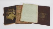
 (2 PC) PURVIS YOUNG X RAND
 MCNALLY COMMERCIAL ATLASDESCRIPTION: Two Rand McNally Commercial Atlas and Marketing Guides. Pg 358-359 has two drawings by American artist Purvis Young, depicting figures silhouettes. Signed. CIRCA: 20th Century ORIGIN: USA DIMENSIONS: (Pages) H. 20.5" x W. 14" CONDITION: Great condition. See lot description for details on item condition. More detailed condition requests can be obtained via email (info@akibaantiques.com) or SMS (305) 333-4134. Any condition statement given, as a courtesy to a client, is only an opinion and should not be treated as a statement of fact. Akiba Antiques shall have no responsibility for any error or omission.
(2 PC) PURVIS YOUNG X RAND
(2 PC) PURVIS YOUNG X RAND MCNALLY COMMERCIAL ATLASDESCRIPTION: Two Rand McNally Commercial Atlas and Marketing Guides. Pg 358-359 has two drawings by American artist Purvis Young, depicting figures silhouettes. Signed. CIRCA: 20th Century ORIGIN: USA DIMENSIONS: (Pages) H. 20.5" x W. 14" CONDITION: Great condition. See lot description for details on item condition. More detailed condition requests can be obtained via email (info@akibaantiques.com) or SMS (305) 333-4134. Any condition statement given, as a courtesy to a client, is only an opinion and should not be treated as a statement of fact. Akiba Antiques shall have no responsibility for any error or omission. -
 RAND MCNALLY TERRESTRIAL GLOBE ON
 MAHOGANY STAND, SECOND QUARTER 20TH CENTURYRAND MCNALLY TERRESTRIAL GLOBE ON MAHOGANY STAND, SECOND QUARTER 20TH CENTURY, globe diameter 18 in., resting on stand with bulbous standard raised on foliate carved excurvate legs ending in brass paw feet - h:41.75in. Provenance: Georgetown Estate Collection
RAND MCNALLY TERRESTRIAL GLOBE ON
RAND MCNALLY TERRESTRIAL GLOBE ON MAHOGANY STAND, SECOND QUARTER 20TH CENTURYRAND MCNALLY TERRESTRIAL GLOBE ON MAHOGANY STAND, SECOND QUARTER 20TH CENTURY, globe diameter 18 in., resting on stand with bulbous standard raised on foliate carved excurvate legs ending in brass paw feet - h:41.75in. Provenance: Georgetown Estate Collection -
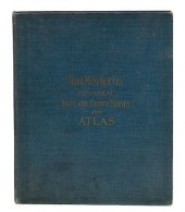 1911 RAND MCNALLY ATLASMeasures 14"
 tall, 11.5" wide. Good original condition. Please Email or call for a detailed condition report. The absence of a condition statement does not imply that the lot is in perfect condition or completely free from wear and tear, imperfections, repairs, restorations or the effects of aging. The majority of the items we sell are Antiques and will show the appropriate wear and Patina. Packaging, Insurance, Handling And Shipping Are Done In House or You Are Welcome To Pick Up In Person Or Make Your Own Shipping Arrangements. Condition: Measures 14" tall, 11.5" wide. Good original condition. Please Email or call for a detailed condition report. The absence of a condition statement does not imply that the lot is in perfect condition or completely free from wear and tear, imperfections, repairs, restorations or the effects of aging. The majority of the items we sell are Antiques and will show the appropriate wear and Patina. Packaging, Insurance, Handling And Shipping Are Done In House or You Are Welcome To Pick Up In Person Or Make Your Own Shipping Arrangements.
1911 RAND MCNALLY ATLASMeasures 14"
1911 RAND MCNALLY ATLASMeasures 14" tall, 11.5" wide. Good original condition. Please Email or call for a detailed condition report. The absence of a condition statement does not imply that the lot is in perfect condition or completely free from wear and tear, imperfections, repairs, restorations or the effects of aging. The majority of the items we sell are Antiques and will show the appropriate wear and Patina. Packaging, Insurance, Handling And Shipping Are Done In House or You Are Welcome To Pick Up In Person Or Make Your Own Shipping Arrangements. Condition: Measures 14" tall, 11.5" wide. Good original condition. Please Email or call for a detailed condition report. The absence of a condition statement does not imply that the lot is in perfect condition or completely free from wear and tear, imperfections, repairs, restorations or the effects of aging. The majority of the items we sell are Antiques and will show the appropriate wear and Patina. Packaging, Insurance, Handling And Shipping Are Done In House or You Are Welcome To Pick Up In Person Or Make Your Own Shipping Arrangements. -
 J. PAUL GOODE POLITICAL SIXTEEN
 INCH GLOBE ON WALNUT STAND Rand McNally & Company Chicago: circa 1929 the globe mounted on a Duncan Phyfe style tripod floor stand the reeded bulbous central standard on three acanthus-carved downswept legs ending in brass paw feet- h: 39 x d: 20.5 in. Provenance: Sykes Collection
J. PAUL GOODE POLITICAL SIXTEEN
J. PAUL GOODE POLITICAL SIXTEEN INCH GLOBE ON WALNUT STAND Rand McNally & Company Chicago: circa 1929 the globe mounted on a Duncan Phyfe style tripod floor stand the reeded bulbous central standard on three acanthus-carved downswept legs ending in brass paw feet- h: 39 x d: 20.5 in. Provenance: Sykes Collection -
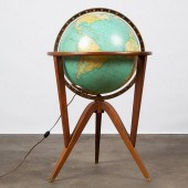 EDWARD WORMLEY FOR RAND MCNALLY
 'COSMOPOLITAN' GLOBEA modern Rand McNally Cosmopolitan?illuminated terrestrial globe on a wooden stand designed by Edward Wormley?for Dunbar. Circa 1960s. Approximately 35 x 21 inches. Condition One foot is missing a brass cap. Otherwise very good condition.
EDWARD WORMLEY FOR RAND MCNALLY
EDWARD WORMLEY FOR RAND MCNALLY 'COSMOPOLITAN' GLOBEA modern Rand McNally Cosmopolitan?illuminated terrestrial globe on a wooden stand designed by Edward Wormley?for Dunbar. Circa 1960s. Approximately 35 x 21 inches. Condition One foot is missing a brass cap. Otherwise very good condition. -
 RAND (AMERICAN, 20TH CENTURY),
 GALAXY ON WHITE Mixed media on board, mid-20th century, signed at lower right, title inscribed to verso and inscribed "67-2," with Georgia Railroad Bank and Trust Company label to verso, framed.
RAND (AMERICAN, 20TH CENTURY),
RAND (AMERICAN, 20TH CENTURY), GALAXY ON WHITE Mixed media on board, mid-20th century, signed at lower right, title inscribed to verso and inscribed "67-2," with Georgia Railroad Bank and Trust Company label to verso, framed. -
 AN VINTAGE MAP, "BLACK AND WHITE
 MILEAGE MAP OF TEXAS,"...AN VINTAGE MAP, "Black and White Mileage Map of Texas," CHICAGO, 1925-1950, ink engraving on paper, by Rand McNally & Company, showing mileage between towns of rail lines regardless of topography, mail routes, electric lines, cities notated by population, with an inset view of the Panhandle, bordered left by principle cities, plates 414 and 415 from original atlas. 20" x 26 1/2" Note: "Rand McNally produced the 1924 atlas automobile "trails" map just eight years after passage of the Federal Aid Road Act of 1916, which provided federal monetary assistance for roads to states with centralized control of highways. Texas created its highway department in 1917...now known as the Texas Department of Transportation. Many early highways simply followed the rights-of-ways of railroad and telegraph lines." Courtesy: David Rumsey Historical Map Collection and Cartography Associates Provenance: Property from a Fortune 500 Energy Company, Houston, Texas. Condition: Some creasing, some text bleed from verso, mild tone, but overall in very good condition, wear commensurate with age. Simpson Galleries strongly encourages in-person inspection of items by the bidder. Statements by Simpson Galleries regarding the condition of objects are for guidance only and should not be relied upon as statements of fact and do not constitute a representation, warranty, or assumption of liability by Simpson Galleries. All lots offered are sold "AS IS."
AN VINTAGE MAP, "BLACK AND WHITE
AN VINTAGE MAP, "BLACK AND WHITE MILEAGE MAP OF TEXAS,"...AN VINTAGE MAP, "Black and White Mileage Map of Texas," CHICAGO, 1925-1950, ink engraving on paper, by Rand McNally & Company, showing mileage between towns of rail lines regardless of topography, mail routes, electric lines, cities notated by population, with an inset view of the Panhandle, bordered left by principle cities, plates 414 and 415 from original atlas. 20" x 26 1/2" Note: "Rand McNally produced the 1924 atlas automobile "trails" map just eight years after passage of the Federal Aid Road Act of 1916, which provided federal monetary assistance for roads to states with centralized control of highways. Texas created its highway department in 1917...now known as the Texas Department of Transportation. Many early highways simply followed the rights-of-ways of railroad and telegraph lines." Courtesy: David Rumsey Historical Map Collection and Cartography Associates Provenance: Property from a Fortune 500 Energy Company, Houston, Texas. Condition: Some creasing, some text bleed from verso, mild tone, but overall in very good condition, wear commensurate with age. Simpson Galleries strongly encourages in-person inspection of items by the bidder. Statements by Simpson Galleries regarding the condition of objects are for guidance only and should not be relied upon as statements of fact and do not constitute a representation, warranty, or assumption of liability by Simpson Galleries. All lots offered are sold "AS IS." -
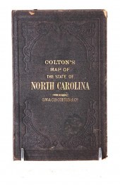 Travel maps of North and South
 Carolina consisting of: COLTON'S MAP OF THE STATE OF NORTH CAROLINA WITH PORTIONS OF ADJOINING STATES 1866. Late 19th century in two parts folded and mounted within hardcover book; THE RAND-MCNALLY VEST POCKET MAP OF SOUTH CAROLINA 1913. New York: Rand McNally & Co. 1913. Folded and mounted within soft paper folded case. STANDARD ROAD MAP OF NORTH CAROLINA AND SOUTH CAROLINA. Published by the Standard Oil Company of New Jersey unframed. H17 1/2'' W23 5/8'' (3pcs) Provenance: Columbia South Carolina private collection. Colton’s: multiple tears and staining along creases. Rand-McNally: tears along creases; paper toned. Standard: good original condition with small tear at left margin.
Travel maps of North and South
Travel maps of North and South Carolina consisting of: COLTON'S MAP OF THE STATE OF NORTH CAROLINA WITH PORTIONS OF ADJOINING STATES 1866. Late 19th century in two parts folded and mounted within hardcover book; THE RAND-MCNALLY VEST POCKET MAP OF SOUTH CAROLINA 1913. New York: Rand McNally & Co. 1913. Folded and mounted within soft paper folded case. STANDARD ROAD MAP OF NORTH CAROLINA AND SOUTH CAROLINA. Published by the Standard Oil Company of New Jersey unframed. H17 1/2'' W23 5/8'' (3pcs) Provenance: Columbia South Carolina private collection. Colton’s: multiple tears and staining along creases. Rand-McNally: tears along creases; paper toned. Standard: good original condition with small tear at left margin.
...many more examples with full details are available to our members - Learn more
Easy & Visual methods to Identify & Appraise Antiques & Collectibles
EASY. FAST. ACCURATE.
Research at its best
We are here to help!
Our research tools include:

Thousands of makers marks for PORCELAIN, POTTERY CHINAWARE, FIGURINES, VASES
see details...

Thousands of marks & hallmarks for SILVER & JEWELRY, PEWTER, PRECIOUS METALS, SILVERPLATE
see details...
