Pricing Guides & Dictionary of Makers Marks for Antiques & Collectibles
A few examples of appraisal values for
SOUTH CAROLINA
Search our price guide for your own treasures
-
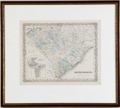
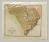
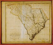
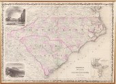
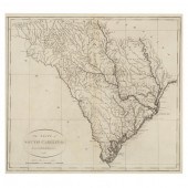
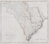
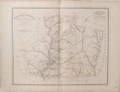
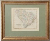 Map of South Carolina by Fielding
 Lucas Jr. (1781-1854) STH. CAROLINA. Baltimore: F. Lucas Jr. n.d. [19th century]. Handcolored framed. sight size: H11 1/2'' W13'' together with: COLTON'S MAP OF SOUTH CAROLINA. New York: Johnson & Browning 1855. Handcolored framed inset with PLAN OF CHARLESTON. sight size: H13'' W15 1/2'' (2pcs) Provenance: From the collection of a South Carolina scholar.
Map of South Carolina by Fielding
Map of South Carolina by Fielding Lucas Jr. (1781-1854) STH. CAROLINA. Baltimore: F. Lucas Jr. n.d. [19th century]. Handcolored framed. sight size: H11 1/2'' W13'' together with: COLTON'S MAP OF SOUTH CAROLINA. New York: Johnson & Browning 1855. Handcolored framed inset with PLAN OF CHARLESTON. sight size: H13'' W15 1/2'' (2pcs) Provenance: From the collection of a South Carolina scholar. -
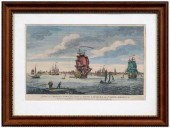 18th century Charleston
 engraving, South Carolina, "A View of Charles Town, the Capital of South Carolina, in North America", published by Carrington Bowles, London, circa 1772, after Thomas Mellis, hand colored, on laid paper, 7-3/4 x 11-1/8 in. (page); modern wood frame. Trimmed including plate mark at right margin, hinged with archival tape, cloth tape remnants, adhesive residue in top margin, toning, creases and folds, stains in margins, pencil inscriptions; frame with abrasions. John Bivins, Jr. Collection
18th century Charleston
18th century Charleston engraving, South Carolina, "A View of Charles Town, the Capital of South Carolina, in North America", published by Carrington Bowles, London, circa 1772, after Thomas Mellis, hand colored, on laid paper, 7-3/4 x 11-1/8 in. (page); modern wood frame. Trimmed including plate mark at right margin, hinged with archival tape, cloth tape remnants, adhesive residue in top margin, toning, creases and folds, stains in margins, pencil inscriptions; frame with abrasions. John Bivins, Jr. Collection -
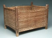 Low country South Carolina
 basket, mortised wooden frame, woven oak split sides and base, probably coastal South Carolina, 19th century, 17-1/2 x 25 x 19 in. Several minor breaks, some wooden elements split and/or warped.
Low country South Carolina
Low country South Carolina basket, mortised wooden frame, woven oak split sides and base, probably coastal South Carolina, 19th century, 17-1/2 x 25 x 19 in. Several minor breaks, some wooden elements split and/or warped. -
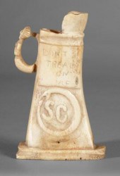 South Carolina carved bone flask,
 trapezoidal pitcher on conforming base carved from one piece of bone, applied figural handle with clasped hands, one side with carved palmetto tree on mound in relief, opposite with "SC" surrounded by snake biting its tail below shallow inscription "DON'T/TREAD/ON/ME", South Carolina, late 18th or 19th century, 4-3/4 in. Good condition, some surface grime. Sumpter Priddy III, Inc., Alexandria, Virginia, 1998.
South Carolina carved bone flask,
South Carolina carved bone flask, trapezoidal pitcher on conforming base carved from one piece of bone, applied figural handle with clasped hands, one side with carved palmetto tree on mound in relief, opposite with "SC" surrounded by snake biting its tail below shallow inscription "DON'T/TREAD/ON/ME", South Carolina, late 18th or 19th century, 4-3/4 in. Good condition, some surface grime. Sumpter Priddy III, Inc., Alexandria, Virginia, 1998. -
 19th century maps of South Carolina
 SOUTH CAROLINA inset with PLAN OF CHARLESTON. New York: J.H. Colton & Co. 1855. Handcolored matted and framed; sight size: H13 3/4'' W17''; A NEW MAP OF SOUTH CAROLINA. Philadelphia: Thomas Cowperthwait 1850. Also inset with plan of Charleston handcolored matted and framed; sight size; H12'' W14 3/4''; MAP OF THE STATE OF SOUTH CAROLINA ISSUED BY THE DEPARTMENT OF AGRICULTURE OF SOUTH CAROLINA 1883. New York: G.W. & C.B. Colton 1883. (3pcs) Provenance: Columbia South Carolina private collection.
19th century maps of South Carolina
19th century maps of South Carolina SOUTH CAROLINA inset with PLAN OF CHARLESTON. New York: J.H. Colton & Co. 1855. Handcolored matted and framed; sight size: H13 3/4'' W17''; A NEW MAP OF SOUTH CAROLINA. Philadelphia: Thomas Cowperthwait 1850. Also inset with plan of Charleston handcolored matted and framed; sight size; H12'' W14 3/4''; MAP OF THE STATE OF SOUTH CAROLINA ISSUED BY THE DEPARTMENT OF AGRICULTURE OF SOUTH CAROLINA 1883. New York: G.W. & C.B. Colton 1883. (3pcs) Provenance: Columbia South Carolina private collection. -
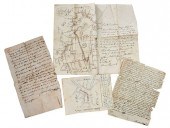 SOUTH CAROLINA
 DOCUMENTSapproximately 30 pieces, late 18th to late 19th century, numerous land deeds, many for Spartanburg and surrounding counties; hand drawn maps, one showing Cyprus Pond, thought to be near Orangeburg; notary appointment from 1894 signed by Governor Benjamin Tillman; reprint of The Carolina Spartan: Special Edition from April 30, 1865 telling of Stoneman's Raid; personal writings, marked "Novels and Romances"; various receipts and bills; bank letter with postally cancelled cover for Bank of Anderson, largest 14 x 17 in. Provenance: Private Collection Condition: considerable wear, foxing, stains (red dye in places), folds, tears, paper losses, separations
SOUTH CAROLINA
SOUTH CAROLINA DOCUMENTSapproximately 30 pieces, late 18th to late 19th century, numerous land deeds, many for Spartanburg and surrounding counties; hand drawn maps, one showing Cyprus Pond, thought to be near Orangeburg; notary appointment from 1894 signed by Governor Benjamin Tillman; reprint of The Carolina Spartan: Special Edition from April 30, 1865 telling of Stoneman's Raid; personal writings, marked "Novels and Romances"; various receipts and bills; bank letter with postally cancelled cover for Bank of Anderson, largest 14 x 17 in. Provenance: Private Collection Condition: considerable wear, foxing, stains (red dye in places), folds, tears, paper losses, separations -
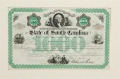 South Carolina Reconstruction-era
 bond State of South Carolina $1 000 Bond issued under act of March 23d 1869 signed by Governor Robert K. Scott. With vignettes of George Washington cotton field and ship matted. sight size: H8 1/2'' W13 1/2'' Provenance: Columbia South Carolina private collection.
South Carolina Reconstruction-era
South Carolina Reconstruction-era bond State of South Carolina $1 000 Bond issued under act of March 23d 1869 signed by Governor Robert K. Scott. With vignettes of George Washington cotton field and ship matted. sight size: H8 1/2'' W13 1/2'' Provenance: Columbia South Carolina private collection. -
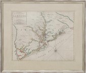
 John Wilson's map of South Carolina
 Wilson John. A MAP OF SOUTH CAROLINA. Philadelphia: H. Tanner 1822. In four parts each hand-colored and matted all encased within custom clamshell box accompanied by an essay on its historical importance by John Long. Provenance: Columbia South Carolina private collection. From the University of South Carolina Libraries Special Collections Department sold to benefit the aquisitions fund. All sheets with various degrees of toning age discoloration foxing worn edges and small tears or losses along edges (with the upper left map providing the worst example); all with archival tape on verso top edges; bottom two maps with a few small professionally mended tears visible on verso.
John Wilson's map of South Carolina
John Wilson's map of South Carolina Wilson John. A MAP OF SOUTH CAROLINA. Philadelphia: H. Tanner 1822. In four parts each hand-colored and matted all encased within custom clamshell box accompanied by an essay on its historical importance by John Long. Provenance: Columbia South Carolina private collection. From the University of South Carolina Libraries Special Collections Department sold to benefit the aquisitions fund. All sheets with various degrees of toning age discoloration foxing worn edges and small tears or losses along edges (with the upper left map providing the worst example); all with archival tape on verso top edges; bottom two maps with a few small professionally mended tears visible on verso. -
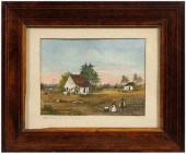
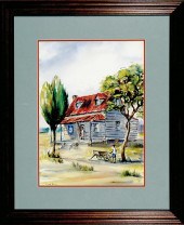
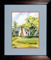
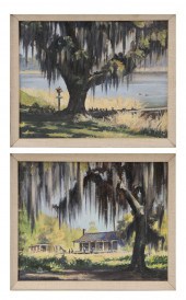 American School (20th century)
 Two South Carolina related scen
American School (20th century)
American School (20th century) Two South Carolina related scen -
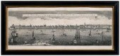 18th century Charleston
 engraving, South Carolina, "An Exact Prospect of Charlestown, the Metropolis of the Province of South Carolina", panoramic view by William Toms, after Bishop Roberts, second edition (1779), originally published in The London Magazine , June 1762, uncolored, on laid paper, 8 x 20-1/4 in. (sight); modern wood frame. Folds and creases, minor smudges, toning, areas of foxing, possible restorations, not examined out of frame; frame with abrasions. David Stockwell Antiques, Willmington, Delaware, 1972
18th century Charleston
18th century Charleston engraving, South Carolina, "An Exact Prospect of Charlestown, the Metropolis of the Province of South Carolina", panoramic view by William Toms, after Bishop Roberts, second edition (1779), originally published in The London Magazine , June 1762, uncolored, on laid paper, 8 x 20-1/4 in. (sight); modern wood frame. Folds and creases, minor smudges, toning, areas of foxing, possible restorations, not examined out of frame; frame with abrasions. David Stockwell Antiques, Willmington, Delaware, 1972 -
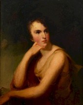 SOUTH CAROLINA PORTRAIT OF A
 LADYSouth Carolina school, manner of Thomas Sully, oil on panel half-length portrait of a woman with brown eyes and brown curls, depicted in a Romantic pose with her waist and head slightly turned and gazing to the left, resting her chin against her right hand, her right elbow atop her left wrist. Although wearing a gold dress, her arms are bare; a red drape sits across right arm and shoulder. The panel on which the image is painted appears to be mahogany and there is an unusual wooden grid brace across the back, presumably to allow for shrinkage and expansion and prevent warping. Antique, but not original, giltwood frame with Janneau's Art Store, Charleston, framing label en verso. 25-1/2" x 20" sight, 30-1/2" x 25-1/4" framed. Circa 1830. Provenance: the family of Dr. William Davis Melton, of Columbia, South Carolina, who was from 1922-1926 the president of South Carolina University (now called the University of South Carolina). The painting hung in the President's House on Pendleton Street until his death in 1926, and then descended to his daughter Henrietta Melton Durham; it was purchased from her estate by her niece Anne Ford Melton Kimzey of Signal Mountain, Tenn. and displayed there for several years before being acquired by the current consignor. It is thought to depict a family member, possibly Dr. Melton's grandmother, Cynthia Jane Miller (b. 1810). Condition: Extensive inpainting including facial area about 25%.
SOUTH CAROLINA PORTRAIT OF A
SOUTH CAROLINA PORTRAIT OF A LADYSouth Carolina school, manner of Thomas Sully, oil on panel half-length portrait of a woman with brown eyes and brown curls, depicted in a Romantic pose with her waist and head slightly turned and gazing to the left, resting her chin against her right hand, her right elbow atop her left wrist. Although wearing a gold dress, her arms are bare; a red drape sits across right arm and shoulder. The panel on which the image is painted appears to be mahogany and there is an unusual wooden grid brace across the back, presumably to allow for shrinkage and expansion and prevent warping. Antique, but not original, giltwood frame with Janneau's Art Store, Charleston, framing label en verso. 25-1/2" x 20" sight, 30-1/2" x 25-1/4" framed. Circa 1830. Provenance: the family of Dr. William Davis Melton, of Columbia, South Carolina, who was from 1922-1926 the president of South Carolina University (now called the University of South Carolina). The painting hung in the President's House on Pendleton Street until his death in 1926, and then descended to his daughter Henrietta Melton Durham; it was purchased from her estate by her niece Anne Ford Melton Kimzey of Signal Mountain, Tenn. and displayed there for several years before being acquired by the current consignor. It is thought to depict a family member, possibly Dr. Melton's grandmother, Cynthia Jane Miller (b. 1810). Condition: Extensive inpainting including facial area about 25%. -
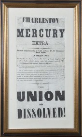 Rare Charleston Mercury South
 Carolina secession broadside dated 20 December 1860 detailing the unanimous vote of the delegates of the Secession Convention to repeal the 1778 ratification of the Constitution thereby declaring ''the union now subsisting between South Carolina and other States under the name of 'The United States of America' '' dissolved. Printed broadside mounted matted and framed. page size: H20'' W9 3/4'' overall: H27'' W16 1/2'' Provenance: South Carolina private collection. Other Notes: The ''extra'' announcing the passage of the Ordinance of Secession at 1:15 P.M. was printed within a few minutes of the actual vote and then distributed to the crowd that had assembled outside the newspaper office. This broadside was printed before the ordinance was signed on the evening of 20 December. Paper with creases tears and staining. Has been professionally stabilized between two pieces of membrane-thin conservation paper after damaged in house fire. Back   Inquiry    Previous Item  Next Item © Charlton Hall Auctions. Images descriptions and condition reports used on this site are original copyright material and are not to be reproduced without permission. For further information telephone 803.779.5678   © 2012 CHARLTON HALL GALLERIES INC.
Rare Charleston Mercury South
Rare Charleston Mercury South Carolina secession broadside dated 20 December 1860 detailing the unanimous vote of the delegates of the Secession Convention to repeal the 1778 ratification of the Constitution thereby declaring ''the union now subsisting between South Carolina and other States under the name of 'The United States of America' '' dissolved. Printed broadside mounted matted and framed. page size: H20'' W9 3/4'' overall: H27'' W16 1/2'' Provenance: South Carolina private collection. Other Notes: The ''extra'' announcing the passage of the Ordinance of Secession at 1:15 P.M. was printed within a few minutes of the actual vote and then distributed to the crowd that had assembled outside the newspaper office. This broadside was printed before the ordinance was signed on the evening of 20 December. Paper with creases tears and staining. Has been professionally stabilized between two pieces of membrane-thin conservation paper after damaged in house fire. Back   Inquiry    Previous Item  Next Item © Charlton Hall Auctions. Images descriptions and condition reports used on this site are original copyright material and are not to be reproduced without permission. For further information telephone 803.779.5678   © 2012 CHARLTON HALL GALLERIES INC. -
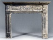 Very fine Federal Southern mantle
 surround, elaborate stepped cornice, quarter fan, leaf and anthemion appliqués over molded pilasters, attributed to North or South Carolina, early 19th century, 59 x 74 x 9-1/4 in. Surface burning and charring over much of mantle, extensive paint losses and other damages, lacking one side element. Salvaged from "Diamond in the Dust", early Flat Rock, North Carolina, home that burned in 1960s; The Estate of the Late Francis P. Fretwell, Spartanburg, South Carolina
Very fine Federal Southern mantle
Very fine Federal Southern mantle surround, elaborate stepped cornice, quarter fan, leaf and anthemion appliqués over molded pilasters, attributed to North or South Carolina, early 19th century, 59 x 74 x 9-1/4 in. Surface burning and charring over much of mantle, extensive paint losses and other damages, lacking one side element. Salvaged from "Diamond in the Dust", early Flat Rock, North Carolina, home that burned in 1960s; The Estate of the Late Francis P. Fretwell, Spartanburg, South Carolina -
 Southern watercolor, E. McIntire,
 Southern genre scene with black figures around cabins, in cotton field, titled on mat "Cotton Field in South Carolina", watercolor and gouache on paper, inscribed verso "Mrs. Francis McIntire/38 S. Battery/Charleston, S.C. 29401", American School, 20th century, 8-1/2 x 11-3/8 in.; early 20th century inlaid wood frame. Small hole at edge lower left; frame with loss to wood at sight edge, abrasions.
Southern watercolor, E. McIntire,
Southern watercolor, E. McIntire, Southern genre scene with black figures around cabins, in cotton field, titled on mat "Cotton Field in South Carolina", watercolor and gouache on paper, inscribed verso "Mrs. Francis McIntire/38 S. Battery/Charleston, S.C. 29401", American School, 20th century, 8-1/2 x 11-3/8 in.; early 20th century inlaid wood frame. Small hole at edge lower left; frame with loss to wood at sight edge, abrasions. -
 Charleston, South Carolina
 needlework, kneeling hunter with dog before a cross, stitched at bottom "Worked by Elizabeth Malone at the Academy of the Sisters of Our Lady of Mercy. Charleston S. Carolina", wool on canvas, circa 1860-1870, unframed, 17-1/2 x 20-3/4 in. Several horizontal splits in canvas, losses to wool, fading, grime. Private Collection, Charlotte, North Carolina.
Charleston, South Carolina
Charleston, South Carolina needlework, kneeling hunter with dog before a cross, stitched at bottom "Worked by Elizabeth Malone at the Academy of the Sisters of Our Lady of Mercy. Charleston S. Carolina", wool on canvas, circa 1860-1870, unframed, 17-1/2 x 20-3/4 in. Several horizontal splits in canvas, losses to wool, fading, grime. Private Collection, Charlotte, North Carolina. -
 1799 South Carolina map,
 imprinted "Engraved for New Encyclopaedia Published by I. Low, New York", Native American villages noted in west, hand colored, 8 x 10 in. Minor creases, light stains, minor edge chips lower margin. Collection of the Late John Bivins
1799 South Carolina map,
1799 South Carolina map, imprinted "Engraved for New Encyclopaedia Published by I. Low, New York", Native American villages noted in west, hand colored, 8 x 10 in. Minor creases, light stains, minor edge chips lower margin. Collection of the Late John Bivins -
 Mills's Atlas of South Carolina and
 Carolina Map by Carey and Lea Mills Robert. ATLAS OF THE STATE OF SOUTH CAROLINA. Columbia SC: Lucy Hampton Bostick and Fant. H. Thornley 1938. With 29 handcolored maps of South Carolina and its districts numbered 347 of 350; together with: Carez J. CARTE GEOGRAPHIQUE STATISTIQUE ET HISTORIQUE DE LA CAROLINE DU SUD. Paris: J. Carez 1825. map size: H17 3/4'' W24 1/8'' (2pcs)
Mills's Atlas of South Carolina and
Mills's Atlas of South Carolina and Carolina Map by Carey and Lea Mills Robert. ATLAS OF THE STATE OF SOUTH CAROLINA. Columbia SC: Lucy Hampton Bostick and Fant. H. Thornley 1938. With 29 handcolored maps of South Carolina and its districts numbered 347 of 350; together with: Carez J. CARTE GEOGRAPHIQUE STATISTIQUE ET HISTORIQUE DE LA CAROLINE DU SUD. Paris: J. Carez 1825. map size: H17 3/4'' W24 1/8'' (2pcs) -
 Two early South Carolina maps
 18th century CARTE DE LA PARTIE SUD DES ETATS UNIS DE L'AMERIQUE SEPTENTRIONALE by Rigobert Bonne circa 1780 THE STATE OF SOUTH CAROLINA: FROM THE BEST AUTHORITIES by Samuel Lewis circa 1795 colored engravings framed titled in plate sight size: H8 1/2'' W12 1/4'' and H16 1/2'' W19 1/2'' (2pcs) Provenance: Columbia South Carolina estate. Back   Inquiry    Previous Item  Next Item © Charlton Hall Auctions. Images descriptions and condition reports used on this site are original copyright material and are not to be reproduced without permission. For further information telephone 803.779.5678   © 2012 CHARLTON HALL GALLERIES INC.
Two early South Carolina maps
Two early South Carolina maps 18th century CARTE DE LA PARTIE SUD DES ETATS UNIS DE L'AMERIQUE SEPTENTRIONALE by Rigobert Bonne circa 1780 THE STATE OF SOUTH CAROLINA: FROM THE BEST AUTHORITIES by Samuel Lewis circa 1795 colored engravings framed titled in plate sight size: H8 1/2'' W12 1/4'' and H16 1/2'' W19 1/2'' (2pcs) Provenance: Columbia South Carolina estate. Back   Inquiry    Previous Item  Next Item © Charlton Hall Auctions. Images descriptions and condition reports used on this site are original copyright material and are not to be reproduced without permission. For further information telephone 803.779.5678   © 2012 CHARLTON HALL GALLERIES INC. -
 Rare early map of South Carolina by
 Pierre Mortier CARTE PARTICULIERE DE LA CAROLINE. Amsterdam: Pierre Mortier ca.1696. Handcolored framed one of the first maps of South Carolina produced. Features a Charleston street grid and the names of plantation owners throughout the lowcountry. H19'' W23 5/8'' Provenance: From the collection of a South Carolina scholar. Literature: Cumming William P. THE SOUTHEAST IN EARLY MAPS. Chapel Hill: The University of North Carolina Press 1998 map number 121. Good original condition. Paper lightly toned and had age discoloration; corners are intact.
Rare early map of South Carolina by
Rare early map of South Carolina by Pierre Mortier CARTE PARTICULIERE DE LA CAROLINE. Amsterdam: Pierre Mortier ca.1696. Handcolored framed one of the first maps of South Carolina produced. Features a Charleston street grid and the names of plantation owners throughout the lowcountry. H19'' W23 5/8'' Provenance: From the collection of a South Carolina scholar. Literature: Cumming William P. THE SOUTHEAST IN EARLY MAPS. Chapel Hill: The University of North Carolina Press 1998 map number 121. Good original condition. Paper lightly toned and had age discoloration; corners are intact. -
 Anne Ball South Carolina (mid
 20th Century) RURAL COASTAL CAROLINA SCENE WITH CABIN watercolor framed signed: lower left sight size: H19'' W14'' Provenance: Purchased from the artist in the 1960s. Moore South Carolina private collection. Back   Inquiry    Previous Item  Next Item © Charlton Hall Auctions. Images descriptions and condition reports used on this site are original copyright material and are not to be reproduced without permission. For further information telephone 803.779.5678   © 2012 CHARLTON HALL GALLERIES INC.
Anne Ball South Carolina (mid
Anne Ball South Carolina (mid 20th Century) RURAL COASTAL CAROLINA SCENE WITH CABIN watercolor framed signed: lower left sight size: H19'' W14'' Provenance: Purchased from the artist in the 1960s. Moore South Carolina private collection. Back   Inquiry    Previous Item  Next Item © Charlton Hall Auctions. Images descriptions and condition reports used on this site are original copyright material and are not to be reproduced without permission. For further information telephone 803.779.5678   © 2012 CHARLTON HALL GALLERIES INC. -
 Anne Ball South Carolina (mid
 20th Century) CHARLESTON LOWCOUNTRY CABIN watercolor framed signed: lower right sight size: H15'' W11 1/4'' Provenance: Purchased from the artist in the 1960s. Moore South Carolina private collection. Back   Inquiry    Previous Item  Next Item © Charlton Hall Auctions. Images descriptions and condition reports used on this site are original copyright material and are not to be reproduced without permission. For further information telephone 803.779.5678   © 2012 CHARLTON HALL GALLERIES INC.
Anne Ball South Carolina (mid
Anne Ball South Carolina (mid 20th Century) CHARLESTON LOWCOUNTRY CABIN watercolor framed signed: lower right sight size: H15'' W11 1/4'' Provenance: Purchased from the artist in the 1960s. Moore South Carolina private collection. Back   Inquiry    Previous Item  Next Item © Charlton Hall Auctions. Images descriptions and condition reports used on this site are original copyright material and are not to be reproduced without permission. For further information telephone 803.779.5678   © 2012 CHARLTON HALL GALLERIES INC. -
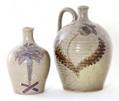 Michel Bayne stoneware jugs South
 Carolina ovoid forms with alkaline glaze and applied slip glaze one featuring palmetto scene from South Carolina state seal and the other with tulip motif one signed on bottom both stamped below handle. H9'' and H11 3/4'' (2pcs) Provenance: Collection of a Southern gentleman.
Michel Bayne stoneware jugs South
Michel Bayne stoneware jugs South Carolina ovoid forms with alkaline glaze and applied slip glaze one featuring palmetto scene from South Carolina state seal and the other with tulip motif one signed on bottom both stamped below handle. H9'' and H11 3/4'' (2pcs) Provenance: Collection of a Southern gentleman. -
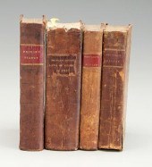
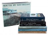 GROUP OF 27 SOUTH CAROLINA
 REFERENCE BOOKSHistorical Atlas of the Rice Plantations of Georgetown County and the Santee River by Suzanne Cameron Linder and Marta Leslie Thacker, Columbia: South Carolina Department of Archives and History, 2001; The Churches of Charleston and the Lowcountry by Mary Moore Jacoby, Columbia: University of South Carolina Press, 1994; Waccamaw Plantations by Julian Stevenson Bolick, Georgetown: Georgetown County Historical Society, 1998; Plantations of the Carolina Low Country by Samuel Stoney, Charleston: Carolina Art Association, 1964, signed by author with personalization; Charleston: Azaleas and Old Bricks by Samuel Stoney, photos by Bayard Wootten, Boston: Houghton Mifflin, 1939; other various titles Condition: most with light rub from normal usage, occasional fraying, foxing, or other incidental wear; Charleston: Azaleas and Old Bricks with original cover present but distressed
GROUP OF 27 SOUTH CAROLINA
GROUP OF 27 SOUTH CAROLINA REFERENCE BOOKSHistorical Atlas of the Rice Plantations of Georgetown County and the Santee River by Suzanne Cameron Linder and Marta Leslie Thacker, Columbia: South Carolina Department of Archives and History, 2001; The Churches of Charleston and the Lowcountry by Mary Moore Jacoby, Columbia: University of South Carolina Press, 1994; Waccamaw Plantations by Julian Stevenson Bolick, Georgetown: Georgetown County Historical Society, 1998; Plantations of the Carolina Low Country by Samuel Stoney, Charleston: Carolina Art Association, 1964, signed by author with personalization; Charleston: Azaleas and Old Bricks by Samuel Stoney, photos by Bayard Wootten, Boston: Houghton Mifflin, 1939; other various titles Condition: most with light rub from normal usage, occasional fraying, foxing, or other incidental wear; Charleston: Azaleas and Old Bricks with original cover present but distressed -
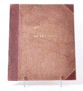
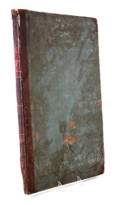 Rare book: Robert Mills' 1838 Atlas
 of South Carolina Mills Robert. ATLAS OF THE STATE OF SOUTH CAROLINA. Philadelphia: J. W. Kite Printer 1838. Contains twenty-eight handcolored district maps and state of South Carolina map title page; bound in cloth boards within custom clamshell box. Provenance: Columbia South Carolina private collection. Maps with varying degrees of small losses tears mends creases age discoloration staining worn edges. Repaired and stabilized. Abbeville map loose; York map with staining and small holes along top margin.
Rare book: Robert Mills' 1838 Atlas
Rare book: Robert Mills' 1838 Atlas of South Carolina Mills Robert. ATLAS OF THE STATE OF SOUTH CAROLINA. Philadelphia: J. W. Kite Printer 1838. Contains twenty-eight handcolored district maps and state of South Carolina map title page; bound in cloth boards within custom clamshell box. Provenance: Columbia South Carolina private collection. Maps with varying degrees of small losses tears mends creases age discoloration staining worn edges. Repaired and stabilized. Abbeville map loose; York map with staining and small holes along top margin. -
 Johnson's map of North and South
 Carolina Johnson A.J. JOHNSON'S NORTH AND SOUTH CAROLINA. New York: Johnson & Browning 1860s. Colored engraving with vignettes of Chimney Rock Table Mountain and a Plan of Charleston framed. sight size: H17 1/2'' W24'' Provenance: Mount Pleasant South Carolina private collection. Not examined out of frame; doesn’t appear to be laid down; some age discoloration and staining along edges consistent with age.
Johnson's map of North and South
Johnson's map of North and South Carolina Johnson A.J. JOHNSON'S NORTH AND SOUTH CAROLINA. New York: Johnson & Browning 1860s. Colored engraving with vignettes of Chimney Rock Table Mountain and a Plan of Charleston framed. sight size: H17 1/2'' W24'' Provenance: Mount Pleasant South Carolina private collection. Not examined out of frame; doesn’t appear to be laid down; some age discoloration and staining along edges consistent with age. -
 MAP, THE STATE OF SOUTH CAROLINA
 FROM THE BEST AUTHORITIES (John Reid: New York, 1796), copperplate engraving without added color, presented behind mat in wooden frame.
MAP, THE STATE OF SOUTH CAROLINA
MAP, THE STATE OF SOUTH CAROLINA FROM THE BEST AUTHORITIES (John Reid: New York, 1796), copperplate engraving without added color, presented behind mat in wooden frame. -
 South Carolina Stoneware Crock by
 Bodie lime glaze 16'' handled.
South Carolina Stoneware Crock by
South Carolina Stoneware Crock by Bodie lime glaze 16'' handled. -
 Early South Carolina map Lewis
 Samuel. THE STATE OF SOUTH CAROLINA: FROM THE BEFT [BEST] AUTHORITIES 1795; published by Mathew Carey c. 1811. map size: H15 1/4'' W17 1/2'' Provenance: California private collection.
Early South Carolina map Lewis
Early South Carolina map Lewis Samuel. THE STATE OF SOUTH CAROLINA: FROM THE BEFT [BEST] AUTHORITIES 1795; published by Mathew Carey c. 1811. map size: H15 1/4'' W17 1/2'' Provenance: California private collection. -
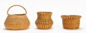 3 PCS, CHARLESTON SWEETGRASS
 BASKETS American/South Carolina, 20th/21st century. Group of three handmade woven baskets comprising handled basket, urn form and vase form woven of sweetgrass, pine needles, and palmetto. Apparently unsigned. Note: Sweetgrass baskets are a Charleston area tradition dating back to the beginning of rice cultivation in the South Carolina Lowcountry. Based in traditional African basketry, they were woven mostly by enslaved peoples as winnowing baskets to remove rice from it's chaff. The basket continues to be a cultural institution as Gullah descendents continue to harvest the materials, weave and sell the baskets in the Charleston City Market and along Highway 17 in Mt. Pleasant. Provenance: From the Lifetime Collection of Billy S. Arant, Jr., Chattanooga, TN. Approx. h. largest 9"
3 PCS, CHARLESTON SWEETGRASS
3 PCS, CHARLESTON SWEETGRASS BASKETS American/South Carolina, 20th/21st century. Group of three handmade woven baskets comprising handled basket, urn form and vase form woven of sweetgrass, pine needles, and palmetto. Apparently unsigned. Note: Sweetgrass baskets are a Charleston area tradition dating back to the beginning of rice cultivation in the South Carolina Lowcountry. Based in traditional African basketry, they were woven mostly by enslaved peoples as winnowing baskets to remove rice from it's chaff. The basket continues to be a cultural institution as Gullah descendents continue to harvest the materials, weave and sell the baskets in the Charleston City Market and along Highway 17 in Mt. Pleasant. Provenance: From the Lifetime Collection of Billy S. Arant, Jr., Chattanooga, TN. Approx. h. largest 9" -
 Maps from Robert Mills' 1825
 Atlas of South Carolina Mills Robert. ATLAS OF THE STATE OF SOUTH CAROLINA. Baltimore: John. D. Troy 1825. With 24 uncolored district maps and State of South Carolina map (title page); unbound. (25pcs) Provenance: Columbia South Carolina private collection. All maps with page creases; age discolorations (especially along creases); toning to paper; wear to edges; and slight tearing along creases; Sumter map being in the worst condition. Does not include Charleston Colleton or Beaufort maps.
Maps from Robert Mills' 1825
Maps from Robert Mills' 1825 Atlas of South Carolina Mills Robert. ATLAS OF THE STATE OF SOUTH CAROLINA. Baltimore: John. D. Troy 1825. With 24 uncolored district maps and State of South Carolina map (title page); unbound. (25pcs) Provenance: Columbia South Carolina private collection. All maps with page creases; age discolorations (especially along creases); toning to paper; wear to edges; and slight tearing along creases; Sumter map being in the worst condition. Does not include Charleston Colleton or Beaufort maps. -
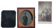 South Carolina Confederate
 portraits circa 1860 consisting of: cased ambrotype of soldier with rifle H3 1/2'' W3 1/8''; tintype of soldier with palmetto background H3 1/4'' W2 5/8'' CDV of soldier holding hat with palmetto background H4 1/8'' W2 1/2'' (3pcs) Provenance: South Carolina private collection. Ambrotype with deterioration to image at left edge; lacking cover. Tintype darkened with scuffing and losses. CDV with staining to top; age discoloration and worn corners.
South Carolina Confederate
South Carolina Confederate portraits circa 1860 consisting of: cased ambrotype of soldier with rifle H3 1/2'' W3 1/8''; tintype of soldier with palmetto background H3 1/4'' W2 5/8'' CDV of soldier holding hat with palmetto background H4 1/8'' W2 1/2'' (3pcs) Provenance: South Carolina private collection. Ambrotype with deterioration to image at left edge; lacking cover. Tintype darkened with scuffing and losses. CDV with staining to top; age discoloration and worn corners. -
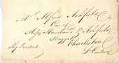 1827 LETTER TO SOUTH CAROLINA,
 VIA SHIPPersonal letter, pre-postage stamps, delivered to Charleston, S.C. Addressed to Alfred Ashfield, informing a delay in their arrival on the ship they're taking because of inclement weather. The second paragraph reads: "By the ship Saluda, you may expect to hear from us again and also to receive some newspapers." Archival tape repairs and unrepaired separations. Measures 9-1/2" x 16" open. Provenance: Obtained directly from a collection of historical paper items -- from the Ashfield, Skaats and McNeal families of New York -- none of which has ever been offered for sale. Several lots of these papers, including historically important pieces, are being offered in today's auction. The family, represented in several of the items in the collection, owned land directly adjacent to Wall Street, and some of the pieces refer to these parcels.
1827 LETTER TO SOUTH CAROLINA,
1827 LETTER TO SOUTH CAROLINA, VIA SHIPPersonal letter, pre-postage stamps, delivered to Charleston, S.C. Addressed to Alfred Ashfield, informing a delay in their arrival on the ship they're taking because of inclement weather. The second paragraph reads: "By the ship Saluda, you may expect to hear from us again and also to receive some newspapers." Archival tape repairs and unrepaired separations. Measures 9-1/2" x 16" open. Provenance: Obtained directly from a collection of historical paper items -- from the Ashfield, Skaats and McNeal families of New York -- none of which has ever been offered for sale. Several lots of these papers, including historically important pieces, are being offered in today's auction. The family, represented in several of the items in the collection, owned land directly adjacent to Wall Street, and some of the pieces refer to these parcels. -
 Views and accounts of the Civil War
 in Columbia South Carolina 19th century consisting of: THE DAILY SOUTHERN GUARDIAN. Columbia SC 13 August 1864. First two pages of scarce Columbia Confederate newspaper with account of ''The Mine at Petersburg '' including a letter from a ''Columbia soldier written in the reserve trenches [which] will be found highly interesting as the account of an eye-witness of competent intelligence and cool deliberate character.'' Obituaries of two Confederate soldiers killed in battle are also printed in this issue; HARPERS' PICTORIAL HISTORY OF THE CIVIL WAR. February 1865. Single sheet with ''Plan of Columbia South Carolina'' and image of Wade Hampton; HARPER'S WEEKLY. 20 February 1864. ''Scenes in and around Richland Jail Columbia South Carolina.'' Hand-colored; HARPER'S WEEKLY. 1 April 1865. Famous image of ''General Sherman's Entry into Columbia South Carolina February 17 1865'' on front page; HARPER'S WEEKLY. 1 April 1865. Double-page images of ''Scenes in Columbia South Carolina the morning after the fire.'' Hand-colored; FRANK LESLIE'S ILLUSTRATED NEWSPAPER. 8 April 1865. Single sheet with image ''Appearance of the Prison Pen at Columbia S. C. On the Arrival of Sherman's Army.'' Hand-colored; HARPER'S WEEKLY. 15 April 1865. Complete issue. Includes views of Hampton-Preston mansion and gardens and Sherman's army crossing the Broad and Saluda rivers on their way into Columbia; HARPER'S WEEKLY. 21 July 1866. ''The Ruins of Columbia South Carolina-Richardson Street Looking toward the capitol.'' Hand-colored. (8pcs) Provenance: From the library of a South Carolina scholar.
Views and accounts of the Civil War
Views and accounts of the Civil War in Columbia South Carolina 19th century consisting of: THE DAILY SOUTHERN GUARDIAN. Columbia SC 13 August 1864. First two pages of scarce Columbia Confederate newspaper with account of ''The Mine at Petersburg '' including a letter from a ''Columbia soldier written in the reserve trenches [which] will be found highly interesting as the account of an eye-witness of competent intelligence and cool deliberate character.'' Obituaries of two Confederate soldiers killed in battle are also printed in this issue; HARPERS' PICTORIAL HISTORY OF THE CIVIL WAR. February 1865. Single sheet with ''Plan of Columbia South Carolina'' and image of Wade Hampton; HARPER'S WEEKLY. 20 February 1864. ''Scenes in and around Richland Jail Columbia South Carolina.'' Hand-colored; HARPER'S WEEKLY. 1 April 1865. Famous image of ''General Sherman's Entry into Columbia South Carolina February 17 1865'' on front page; HARPER'S WEEKLY. 1 April 1865. Double-page images of ''Scenes in Columbia South Carolina the morning after the fire.'' Hand-colored; FRANK LESLIE'S ILLUSTRATED NEWSPAPER. 8 April 1865. Single sheet with image ''Appearance of the Prison Pen at Columbia S. C. On the Arrival of Sherman's Army.'' Hand-colored; HARPER'S WEEKLY. 15 April 1865. Complete issue. Includes views of Hampton-Preston mansion and gardens and Sherman's army crossing the Broad and Saluda rivers on their way into Columbia; HARPER'S WEEKLY. 21 July 1866. ''The Ruins of Columbia South Carolina-Richardson Street Looking toward the capitol.'' Hand-colored. (8pcs) Provenance: From the library of a South Carolina scholar. -
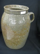
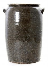 Southern stoneware storage jar
 Upcountry South Carolina circa 1890 alkaline glaze cylindrical body with tooled rim and applied tab handles and glaze rutile at all sides. H18'' W13 1/2'' Provenance: South Carolina private collection.
Southern stoneware storage jar
Southern stoneware storage jar Upcountry South Carolina circa 1890 alkaline glaze cylindrical body with tooled rim and applied tab handles and glaze rutile at all sides. H18'' W13 1/2'' Provenance: South Carolina private collection. -
 Southern law, four works:
 imprints from Milledgeville, Athens, Charleston, 1814-1837; detailed listing available.
Southern law, four works:
Southern law, four works: imprints from Milledgeville, Athens, Charleston, 1814-1837; detailed listing available. -
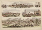
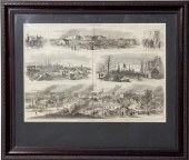 Harper's Weekly feature the Burning
 of Columbia South Carolina SCENES IN COLUMBIA SOUTH CAROLINA THE MORNING AFTER THE FIRE. Harper's Weekly February 1865. Including GENERAL SHERMAN RECEIVING 'THE MARCH TO THE SEA' INTERIOR OF OFFICER'S PRISON ESCAPED PRISONERS AIDING UNION CITIZENS RUINS OF COLUMBIA FROM THE CAPITOL LOOKING NORTH STATE CAPITOL FEB 18/65. Framed uncolored. sight size: H14 3/8'' W20 1/2'' Provenance: From the collection of a South Carolina scholar.
Harper's Weekly feature the Burning
Harper's Weekly feature the Burning of Columbia South Carolina SCENES IN COLUMBIA SOUTH CAROLINA THE MORNING AFTER THE FIRE. Harper's Weekly February 1865. Including GENERAL SHERMAN RECEIVING 'THE MARCH TO THE SEA' INTERIOR OF OFFICER'S PRISON ESCAPED PRISONERS AIDING UNION CITIZENS RUINS OF COLUMBIA FROM THE CAPITOL LOOKING NORTH STATE CAPITOL FEB 18/65. Framed uncolored. sight size: H14 3/8'' W20 1/2'' Provenance: From the collection of a South Carolina scholar.
...many more examples with full details are available to our members - Learn more
Easy & Visual methods to Identify & Appraise Antiques & Collectibles
EASY. FAST. ACCURATE.
Research at its best
We are here to help!
Our research tools include:

Thousands of makers marks for PORCELAIN, POTTERY CHINAWARE, FIGURINES, VASES
see details...

Thousands of marks & hallmarks for SILVER & JEWELRY, PEWTER, PRECIOUS METALS, SILVERPLATE
see details...
