Pricing Guides & Dictionary of Makers Marks for Antiques & Collectibles
A few examples of appraisal values for
STATE OF TEXAS
Search our price guide for your own treasures
-
 WINCHESTER TEXAS 1836/1986 RIFLE
 & CARBINE, SN 005Scarce Winchester Texas1986 Sesquicentennial commemorative rifle and carbine set #5, made in Hartford, Ct., consisting of: (1) Model 94 Saddle Ring Carbine, 38.55 caliber, lever action, 18.5" gold plated barrel bands, the gold plated receiver engraved with historic Texas scenes, the barrel with gold etched "1836-Texas-1986," presentation grade walnut stock; (1) Model 94 rifle, 38-55 caliber, lever action, 20" barrel, etched Texas history scenes on the receiver with a gold outline of the State of Texas at top, the barrel with "1836-Texas-1986" and Sesquicentennial, presentation grade stock; (1) bowie knife by Western Cutlery etched in gold with historic Texas scenes; (1) Texas Sesquicentennial medal, all housed in the Winchester mahogany lockable presentation case with inset gold plated Texas label, Serial Numbers: TEXM005, TSRM005, case: 3.5"h, 46.5"w, 13.5"d, *REQUIRES FFL TRANSFER* *Provenance: Winchester produced only 150 sets of this offering. The first 13 were presentation sets and Winchester did not offer them for sale. Set No. 1 was given to then U.S. President Ronald Regan, sets two and three were given to the governor of the State of Texas and to the Texas Speaker of the House, set five was given to Dallas Cowboy football legend Walt Garrison who had assisted Winchester. Our consignor operated a Texas firearm store in 1986 and purchased several of Winchester sets for resale. Among those sets was #32, also the uniform number of Walt Garrison. A trade was made. Lot photos include one of Garrison and our consignor. Our consignor states that the firearms have never been fired and the levers have not been cycled or racked.*
WINCHESTER TEXAS 1836/1986 RIFLE
WINCHESTER TEXAS 1836/1986 RIFLE & CARBINE, SN 005Scarce Winchester Texas1986 Sesquicentennial commemorative rifle and carbine set #5, made in Hartford, Ct., consisting of: (1) Model 94 Saddle Ring Carbine, 38.55 caliber, lever action, 18.5" gold plated barrel bands, the gold plated receiver engraved with historic Texas scenes, the barrel with gold etched "1836-Texas-1986," presentation grade walnut stock; (1) Model 94 rifle, 38-55 caliber, lever action, 20" barrel, etched Texas history scenes on the receiver with a gold outline of the State of Texas at top, the barrel with "1836-Texas-1986" and Sesquicentennial, presentation grade stock; (1) bowie knife by Western Cutlery etched in gold with historic Texas scenes; (1) Texas Sesquicentennial medal, all housed in the Winchester mahogany lockable presentation case with inset gold plated Texas label, Serial Numbers: TEXM005, TSRM005, case: 3.5"h, 46.5"w, 13.5"d, *REQUIRES FFL TRANSFER* *Provenance: Winchester produced only 150 sets of this offering. The first 13 were presentation sets and Winchester did not offer them for sale. Set No. 1 was given to then U.S. President Ronald Regan, sets two and three were given to the governor of the State of Texas and to the Texas Speaker of the House, set five was given to Dallas Cowboy football legend Walt Garrison who had assisted Winchester. Our consignor operated a Texas firearm store in 1986 and purchased several of Winchester sets for resale. Among those sets was #32, also the uniform number of Walt Garrison. A trade was made. Lot photos include one of Garrison and our consignor. Our consignor states that the firearms have never been fired and the levers have not been cycled or racked.* -
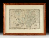
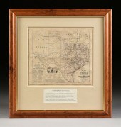
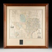
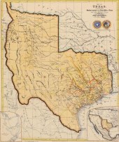 FRAMED MAP OF THE STATE OF
 TEXASFramed map of the state of Texas, compiled from Surveys recorded in the Land Office of Texas and other Official Surveys, with likely later partial hand-coloring, originally published by John Arrowsmith (United Kingdom, 1790-1873), mounted on board, no visible crease, sight: approx 24"h, 20.25"w, overall: approx 32.5"h, 28"w, 10lbs **Provenance: From the Estate of Huey Keeney of Tyler, Texas**
FRAMED MAP OF THE STATE OF
FRAMED MAP OF THE STATE OF TEXASFramed map of the state of Texas, compiled from Surveys recorded in the Land Office of Texas and other Official Surveys, with likely later partial hand-coloring, originally published by John Arrowsmith (United Kingdom, 1790-1873), mounted on board, no visible crease, sight: approx 24"h, 20.25"w, overall: approx 32.5"h, 28"w, 10lbs **Provenance: From the Estate of Huey Keeney of Tyler, Texas** -
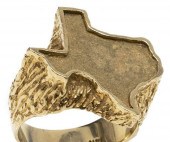 ESTATE GENTS 14KT YELLOW GOLD STATE
 OF TEXAS RINGEstate Gents 14kt yellow gold ring, in the form of the state of Texas, textured shoulder, stamped 14k, approx size 9.75-10,18 grams **Provenance: a Florida estate**
ESTATE GENTS 14KT YELLOW GOLD STATE
ESTATE GENTS 14KT YELLOW GOLD STATE OF TEXAS RINGEstate Gents 14kt yellow gold ring, in the form of the state of Texas, textured shoulder, stamped 14k, approx size 9.75-10,18 grams **Provenance: a Florida estate** -
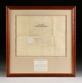
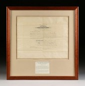
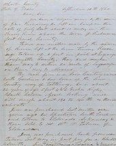 RARE "CATCH 'JIM RUNAWAY'"
 DOCUMENT, WHARTON COUNTY, STATE OF TEXAS, SEPTEMBER 10TH, 1860 9 ¾"x 7 ?" document, 15" x 12" overall framed Document to the Sheriff of the Hoeyer County, State of Texas, two sided letter with request to capture and return a fugitive slave, who can read and has a map of the United States and Mexico; dated September 10th, 1860. Framed between two glass panes in silver color frame. Offered with printed transcript of the letter. Provenance: private lifetime collection of John L. Ford, Curator and Historian of Soldiers & Sailors Memorial and Museum Hall, Pittsburgh, and Director of Ed. Devision at The Heinz Historical Center and Museum of Western Pennsylvania.
RARE "CATCH 'JIM RUNAWAY'"
RARE "CATCH 'JIM RUNAWAY'" DOCUMENT, WHARTON COUNTY, STATE OF TEXAS, SEPTEMBER 10TH, 1860 9 ¾"x 7 ?" document, 15" x 12" overall framed Document to the Sheriff of the Hoeyer County, State of Texas, two sided letter with request to capture and return a fugitive slave, who can read and has a map of the United States and Mexico; dated September 10th, 1860. Framed between two glass panes in silver color frame. Offered with printed transcript of the letter. Provenance: private lifetime collection of John L. Ford, Curator and Historian of Soldiers & Sailors Memorial and Museum Hall, Pittsburgh, and Director of Ed. Devision at The Heinz Historical Center and Museum of Western Pennsylvania. -
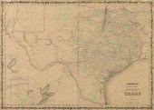 AN AMERICAN CIVIL WAR ERA ANTIQUE
 MAP, "JOHNSON'S NEW M...AN AMERICAN CIVIL WAR ERA ANTIQUE MAP, "Johnson's New Map of the State Of Texas," NEW YORK, 1860-1863, hand colored engraving on paper, by "Johnson & Browning" with "Plan of Sabine Lake," "Plan of Galveston Bay," and "Plan of the Northern Part of Texas," within a lappet scroll encrusted pole border. 17 1/2" x 24 1/4" Provenance: Property from a Fortune 500 Energy Company, Houston, Texas. Condition: Some fading of hand coloring, page fragment from larger Family Atlas, cracked crease at center, some occasional foxing and dark colored spots, mild surface soil/stains but overall in good to very good condition, wear commensurate with age. Simpson Galleries strongly encourages in-person inspection of items by the bidder. Statements by Simpson Galleries regarding the condition of objects are for guidance only and should not be relied upon as statements of fact and do not constitute a representation, warranty, or assumption of liability by Simpson Galleries. All lots offered are sold "AS IS."
AN AMERICAN CIVIL WAR ERA ANTIQUE
AN AMERICAN CIVIL WAR ERA ANTIQUE MAP, "JOHNSON'S NEW M...AN AMERICAN CIVIL WAR ERA ANTIQUE MAP, "Johnson's New Map of the State Of Texas," NEW YORK, 1860-1863, hand colored engraving on paper, by "Johnson & Browning" with "Plan of Sabine Lake," "Plan of Galveston Bay," and "Plan of the Northern Part of Texas," within a lappet scroll encrusted pole border. 17 1/2" x 24 1/4" Provenance: Property from a Fortune 500 Energy Company, Houston, Texas. Condition: Some fading of hand coloring, page fragment from larger Family Atlas, cracked crease at center, some occasional foxing and dark colored spots, mild surface soil/stains but overall in good to very good condition, wear commensurate with age. Simpson Galleries strongly encourages in-person inspection of items by the bidder. Statements by Simpson Galleries regarding the condition of objects are for guidance only and should not be relied upon as statements of fact and do not constitute a representation, warranty, or assumption of liability by Simpson Galleries. All lots offered are sold "AS IS." -
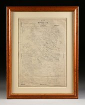
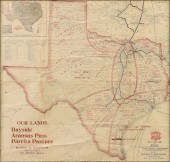 AN ANTIQUE MAP, "MK & T RAILWAY
 SECTIONAL MAP OF TEXAS,...AN ANTIQUE MAP, "MK & T Railway Sectional Map of Texas," 1909, engraving on paper, showing areas traversed by the Missouri, Kansas & Texas Railway, published by Burton & Danforth, Gibbs Building, San Antonio, Texas. 20 1/2" x 21 1/2" Note: This map shows the projected plans for farming productions which included crops of cotton, fruits, vegetables, also livestock, oil, timber and other big business commerce planning at the turn of the 20th Century proposed for the state of Texas. "In 1909, real estate developers E.O. Burton and A.H. Danforth embarked upon a land promotion scheme to take advantage of available land in Aransas Pass. They hired journalist W.H. Vernor to produce the "Aransas Pass Progress", which promoted Aransas Pass and the pending land sale across the country by U.S. Mail. Promoter A.D. Powers was hired to carefully handle the sale to avoid its being seen as a lottery by the postal department. Six thousand tickets, each representing a town lot, were sold for $100 each. Ticket holders were then to come to Aransas Pass to bid on lots; they were not to bid more than $100, and thus the tickets could be exchanged directly for lots. Nearly all 6,000 lots were sold during the auction sales in December 1909. All went well until postal inspectors who had secured tickets purposefully overbid, which muddled the sale and led to several legal battles. As a result of the great land lottery of 1909, Aransas Pass did see substantial growth. The money collected in overbids went into a trust that eventually served to fund public and school libraries." Courtesy The Texas Historical Commission: Texas Historic Sites, Historical Marker Number 2262, Atlas Great Land Lottery of Aransas Pass, Atlas Number 5409002262. Historical marker location: Aransas Pass Public Library at Lamont and Wheeler streets. Provenance: Property from a Fortune 500 Energy Company, Houston, Texas. Condition: Some creasing as issued, dimples and waves to paper, some losses, toning, but overall in good condition, wear commensurate with age. Simpson Galleries strongly encourages in-person inspection of items by the bidder. Statements by Simpson Galleries regarding the condition of objects are for guidance only and should not be relied upon as statements of fact and do not constitute a representation, warranty, or assumption of liability by Simpson Galleries. All lots offered are sold "AS IS."
AN ANTIQUE MAP, "MK & T RAILWAY
AN ANTIQUE MAP, "MK & T RAILWAY SECTIONAL MAP OF TEXAS,...AN ANTIQUE MAP, "MK & T Railway Sectional Map of Texas," 1909, engraving on paper, showing areas traversed by the Missouri, Kansas & Texas Railway, published by Burton & Danforth, Gibbs Building, San Antonio, Texas. 20 1/2" x 21 1/2" Note: This map shows the projected plans for farming productions which included crops of cotton, fruits, vegetables, also livestock, oil, timber and other big business commerce planning at the turn of the 20th Century proposed for the state of Texas. "In 1909, real estate developers E.O. Burton and A.H. Danforth embarked upon a land promotion scheme to take advantage of available land in Aransas Pass. They hired journalist W.H. Vernor to produce the "Aransas Pass Progress", which promoted Aransas Pass and the pending land sale across the country by U.S. Mail. Promoter A.D. Powers was hired to carefully handle the sale to avoid its being seen as a lottery by the postal department. Six thousand tickets, each representing a town lot, were sold for $100 each. Ticket holders were then to come to Aransas Pass to bid on lots; they were not to bid more than $100, and thus the tickets could be exchanged directly for lots. Nearly all 6,000 lots were sold during the auction sales in December 1909. All went well until postal inspectors who had secured tickets purposefully overbid, which muddled the sale and led to several legal battles. As a result of the great land lottery of 1909, Aransas Pass did see substantial growth. The money collected in overbids went into a trust that eventually served to fund public and school libraries." Courtesy The Texas Historical Commission: Texas Historic Sites, Historical Marker Number 2262, Atlas Great Land Lottery of Aransas Pass, Atlas Number 5409002262. Historical marker location: Aransas Pass Public Library at Lamont and Wheeler streets. Provenance: Property from a Fortune 500 Energy Company, Houston, Texas. Condition: Some creasing as issued, dimples and waves to paper, some losses, toning, but overall in good condition, wear commensurate with age. Simpson Galleries strongly encourages in-person inspection of items by the bidder. Statements by Simpson Galleries regarding the condition of objects are for guidance only and should not be relied upon as statements of fact and do not constitute a representation, warranty, or assumption of liability by Simpson Galleries. All lots offered are sold "AS IS." -
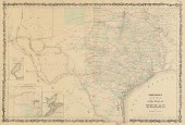
 A RARE ANTIQUE CIVIL WAR ERA MAP,
 "PRESSLER'S MAP OF TH...A RARE ANTIQUE CIVIL WAR ERA MAP, "Pressler's Map of the State of Texas," THE STRAND, GALVESTON, 1862, hand colored engraving on paper, "Compiled from the Records of the General Land Office...by Chas. M. Pressler, Principal draftsman...," published by Jones Root & Co., signed in plate by Commissioner of the General Land Office of the State of Texas, Stephen Crosby (1808-1869), also with two sub maps, "Map of Original Land Districts," and "Map of the Old Colonies," and a "Table of Counties," with vignette showing the original 1852-1853 "State Capitol at Austin," framed with original leather front board. 46 1/2" x 51" Note: The American and Texan landscape teemed with uncertain energy in 1862. The North and South were in the midst of the American Civil War, and in September of the same year President Abraham Lincoln issued the Emancipation Proclamation. Charles W. Pressler, immigrated to Texas in 1846, establishing himself as a surveyor first with Jacob De Cordova. Pressler lead surveying expeditions for the active surveyor; later establishing a career with the General Land Office of the State of Texas in 1850, serving as Principal Draftsman from 1858-1865. It is during this time that Pressler and colleagues were commissioned to produce the present map. Argued as "unquestionably the finest map of Texas of its period," this map improved the State of Texas and the United States' understanding of Texas' geography. Parts of West Texas were still uncharted at this time in history. The map shows the actual and proposed network of railroad lines throughout Texas, indicating population and inhabited areas of the largely undeveloped West Texas territory. The map also details post offices, trails, and roads giving the viewer insight into land travel throughout the State of Texas during the mid 19th century. Outside of man-made transportation routes, the single most detailed part of this map is the extensive system of waterways that surround and run through Texas. The information regarding early colonies, at once, gives the viewer a deep history of the overall cultivation of the State. Indigenous territories are found near the Red River, the map lacking Greer county, which appears in later editions. Finally, an engraving of the State Capitol at Austin is so unusual to see; very few renderings of this building remain. The current State Capitol, which was built in the late 19th century now rests over the foundation of the original 1850s structure. The map was so well informed and drafted that not only the State of Texas, but also the United States Federal government consulted this map and later editions when resolving land disputes in the 19th century. An incredibly rare printing, this map captures the unsettled Texas landscape during the upheaval of the American Civil War. Provenance: Property from a Fortune 500 Energy Company, Houston, Texas. Condition: Professional restoration and repairs including overlaid mesh support, various inpainting, losses, tears, creases, left side with notable yellow toning and foxing spots, waves, bubbling, but overall in good condition, wear commensurate with age and use. Simpson Galleries strongly encourages in-person inspection of items by the bidder. Statements by Simpson Galleries regarding the condition of objects are for guidance only and should not be relied upon as statements of fact and do not constitute a representation, warranty, or assumption of liability by Simpson Galleries. All lots offered are sold "AS IS."
A RARE ANTIQUE CIVIL WAR ERA MAP,
A RARE ANTIQUE CIVIL WAR ERA MAP, "PRESSLER'S MAP OF TH...A RARE ANTIQUE CIVIL WAR ERA MAP, "Pressler's Map of the State of Texas," THE STRAND, GALVESTON, 1862, hand colored engraving on paper, "Compiled from the Records of the General Land Office...by Chas. M. Pressler, Principal draftsman...," published by Jones Root & Co., signed in plate by Commissioner of the General Land Office of the State of Texas, Stephen Crosby (1808-1869), also with two sub maps, "Map of Original Land Districts," and "Map of the Old Colonies," and a "Table of Counties," with vignette showing the original 1852-1853 "State Capitol at Austin," framed with original leather front board. 46 1/2" x 51" Note: The American and Texan landscape teemed with uncertain energy in 1862. The North and South were in the midst of the American Civil War, and in September of the same year President Abraham Lincoln issued the Emancipation Proclamation. Charles W. Pressler, immigrated to Texas in 1846, establishing himself as a surveyor first with Jacob De Cordova. Pressler lead surveying expeditions for the active surveyor; later establishing a career with the General Land Office of the State of Texas in 1850, serving as Principal Draftsman from 1858-1865. It is during this time that Pressler and colleagues were commissioned to produce the present map. Argued as "unquestionably the finest map of Texas of its period," this map improved the State of Texas and the United States' understanding of Texas' geography. Parts of West Texas were still uncharted at this time in history. The map shows the actual and proposed network of railroad lines throughout Texas, indicating population and inhabited areas of the largely undeveloped West Texas territory. The map also details post offices, trails, and roads giving the viewer insight into land travel throughout the State of Texas during the mid 19th century. Outside of man-made transportation routes, the single most detailed part of this map is the extensive system of waterways that surround and run through Texas. The information regarding early colonies, at once, gives the viewer a deep history of the overall cultivation of the State. Indigenous territories are found near the Red River, the map lacking Greer county, which appears in later editions. Finally, an engraving of the State Capitol at Austin is so unusual to see; very few renderings of this building remain. The current State Capitol, which was built in the late 19th century now rests over the foundation of the original 1850s structure. The map was so well informed and drafted that not only the State of Texas, but also the United States Federal government consulted this map and later editions when resolving land disputes in the 19th century. An incredibly rare printing, this map captures the unsettled Texas landscape during the upheaval of the American Civil War. Provenance: Property from a Fortune 500 Energy Company, Houston, Texas. Condition: Professional restoration and repairs including overlaid mesh support, various inpainting, losses, tears, creases, left side with notable yellow toning and foxing spots, waves, bubbling, but overall in good condition, wear commensurate with age and use. Simpson Galleries strongly encourages in-person inspection of items by the bidder. Statements by Simpson Galleries regarding the condition of objects are for guidance only and should not be relied upon as statements of fact and do not constitute a representation, warranty, or assumption of liability by Simpson Galleries. All lots offered are sold "AS IS." -
 AN ANTIQUE POSTAL MAP, "POST
 ROUTE MAP OF THE STATE OF ...AN ANTIQUE POSTAL MAP, "Post Route Map of the State of Texas with adjacent parts of Louisiana, Arkansas, Indian Territory, and the Republic of Mexico," CIRCA 1878, hand colored lithograph on paper, "Designed and constructed under the order of Postmaster General D.M. Key by W.L. Nicholson, Topographer of Post Office Department. The first edition was issued in 1878," in L/R an "Explanation of Mail Service," and in U/L an inset map, "North-Western Portion of Texas," with a Post Office Department oval seal. 42" x 57 1/2" Provenance: Property from a Corporate Collection, Houston, Texas. Condition: Linen mounted and separated at as issued creases, red "X" marks throughout, stains, and overall wear expected and in good to very good condition, wear commensurate with age and use. Simpson Galleries strongly encourages in-person inspection of items by the bidder. Statements by Simpson Galleries regarding the condition of objects are for guidance only and should not be relied upon as statements of fact and do not constitute a representation, warranty, or assumption of liability by Simpson Galleries. All lots offered are sold "AS IS."
AN ANTIQUE POSTAL MAP, "POST
AN ANTIQUE POSTAL MAP, "POST ROUTE MAP OF THE STATE OF ...AN ANTIQUE POSTAL MAP, "Post Route Map of the State of Texas with adjacent parts of Louisiana, Arkansas, Indian Territory, and the Republic of Mexico," CIRCA 1878, hand colored lithograph on paper, "Designed and constructed under the order of Postmaster General D.M. Key by W.L. Nicholson, Topographer of Post Office Department. The first edition was issued in 1878," in L/R an "Explanation of Mail Service," and in U/L an inset map, "North-Western Portion of Texas," with a Post Office Department oval seal. 42" x 57 1/2" Provenance: Property from a Corporate Collection, Houston, Texas. Condition: Linen mounted and separated at as issued creases, red "X" marks throughout, stains, and overall wear expected and in good to very good condition, wear commensurate with age and use. Simpson Galleries strongly encourages in-person inspection of items by the bidder. Statements by Simpson Galleries regarding the condition of objects are for guidance only and should not be relied upon as statements of fact and do not constitute a representation, warranty, or assumption of liability by Simpson Galleries. All lots offered are sold "AS IS." -
 AN ANTEBELLUM MAP, "J. DE CORDOVA'S
 MAP OF THE STATE OF...AN ANTEBELLUM MAP, "J. De Cordova's Map of the State of Texas," NEW YORK, 1856, hand colored lithograph on paper, with hand inscribed pencil inscriptions, the campaign notes beginning near Brownsville, followed by raspberry red dots on important cities/locations/forts following a route traveling north to Cooke, Bosque and Denton Counties, which have triangular and square outlined areas, one reads, "Camp Cooper," a final dot within Indian Territory at Fort Washita; "Compiled from the records of the General Land Office of the State by Robert Creuzbaur, Revised and Corrected by Charles W. Pressler," J.H. Colton & Co, Publishers, J.M. Atwood, Engraver, "Entered according to Act of Congress in the year 1856 by J. De Cordova in the Clerk's Office of the United States District Court for the District of Texas," within a Gothic revival lozenge and quatrefoil chain border, all signatures in plate, with seal of The State of Texas and General Land Office, framed with the original gilt tooled brown leather book front and back cover boards. 36" x 33 1/2" Note: "The First Map of Texas Made by a Houstonian. Few can match the efforts of Jacob de Cordova in promoting land development in Texas...the de Cordova Map of Texas was one of the first examples of a map which relied on the records of the General Land Office. De Cordova was a land promoter from New Orleans, had been a printer in Philadelphia, settled in Houston and following a term in the State Legislature, remained there and established the Texas Herald." Furthermore, The Texas Handbook Online writes about Camp Cooper, "It was established by the Texas legislature in January 1856 and named for United States Army Adjutant General Samuel Cooper. Its mission was to protect the frontier and to monitor the nearby Comanche Indian reservation. The area had been a campsite for three companies of the Fifth Infantry in 1851... The post was founded by Col. Albert Sidney Johnston in January 1856 and became headquarters for four companies of the Second United States Cavalry under the command of Lt. Col. Robert E. Lee. This was Lee's first command of a fort. He remained in charge for fifteen months, from April 9, 1856, until July 22, 1857...Although the camp initially had adequate military stores, it was plagued by severe weather, insects, dust, and irregular supply trains. Rattlesnakes were constant visitors, and Lee kept one as a pet. When he left the camp in 1857 for San Antonio, Maj. George H. Thomas took over." Further research into the three areas drawn in pencil on this map is required to accurately identify what exactly these areas are and if they are any of the military encampments mentioned herein. The hand drawings and specific fort notation show a much needed organized supply route from the coast to these Texas frontier outposts. Provenance: Property from a Corporate Collection, Houston, Texas. Condition: Some creases as issued, bends and handling creases throughout, mild tears and losses, small rubbed holes, but overall expected tone and foxing, but overall in good to very good condition, wear commensurate with age and use. Simpson Galleries strongly encourages in-person inspection of items by the bidder. Statements by Simpson Galleries regarding the condition of objects are for guidance only and should not be relied upon as statements of fact and do not constitute a representation, warranty, or assumption of liability by Simpson Galleries. All lots offered are sold "AS IS."
AN ANTEBELLUM MAP, "J. DE CORDOVA'S
AN ANTEBELLUM MAP, "J. DE CORDOVA'S MAP OF THE STATE OF...AN ANTEBELLUM MAP, "J. De Cordova's Map of the State of Texas," NEW YORK, 1856, hand colored lithograph on paper, with hand inscribed pencil inscriptions, the campaign notes beginning near Brownsville, followed by raspberry red dots on important cities/locations/forts following a route traveling north to Cooke, Bosque and Denton Counties, which have triangular and square outlined areas, one reads, "Camp Cooper," a final dot within Indian Territory at Fort Washita; "Compiled from the records of the General Land Office of the State by Robert Creuzbaur, Revised and Corrected by Charles W. Pressler," J.H. Colton & Co, Publishers, J.M. Atwood, Engraver, "Entered according to Act of Congress in the year 1856 by J. De Cordova in the Clerk's Office of the United States District Court for the District of Texas," within a Gothic revival lozenge and quatrefoil chain border, all signatures in plate, with seal of The State of Texas and General Land Office, framed with the original gilt tooled brown leather book front and back cover boards. 36" x 33 1/2" Note: "The First Map of Texas Made by a Houstonian. Few can match the efforts of Jacob de Cordova in promoting land development in Texas...the de Cordova Map of Texas was one of the first examples of a map which relied on the records of the General Land Office. De Cordova was a land promoter from New Orleans, had been a printer in Philadelphia, settled in Houston and following a term in the State Legislature, remained there and established the Texas Herald." Furthermore, The Texas Handbook Online writes about Camp Cooper, "It was established by the Texas legislature in January 1856 and named for United States Army Adjutant General Samuel Cooper. Its mission was to protect the frontier and to monitor the nearby Comanche Indian reservation. The area had been a campsite for three companies of the Fifth Infantry in 1851... The post was founded by Col. Albert Sidney Johnston in January 1856 and became headquarters for four companies of the Second United States Cavalry under the command of Lt. Col. Robert E. Lee. This was Lee's first command of a fort. He remained in charge for fifteen months, from April 9, 1856, until July 22, 1857...Although the camp initially had adequate military stores, it was plagued by severe weather, insects, dust, and irregular supply trains. Rattlesnakes were constant visitors, and Lee kept one as a pet. When he left the camp in 1857 for San Antonio, Maj. George H. Thomas took over." Further research into the three areas drawn in pencil on this map is required to accurately identify what exactly these areas are and if they are any of the military encampments mentioned herein. The hand drawings and specific fort notation show a much needed organized supply route from the coast to these Texas frontier outposts. Provenance: Property from a Corporate Collection, Houston, Texas. Condition: Some creases as issued, bends and handling creases throughout, mild tears and losses, small rubbed holes, but overall expected tone and foxing, but overall in good to very good condition, wear commensurate with age and use. Simpson Galleries strongly encourages in-person inspection of items by the bidder. Statements by Simpson Galleries regarding the condition of objects are for guidance only and should not be relied upon as statements of fact and do not constitute a representation, warranty, or assumption of liability by Simpson Galleries. All lots offered are sold "AS IS." -
 AN ANTIQUE RECONSTRUCTION ERA
 MAP, "COUNTY MAP OF THE S...AN ANTIQUE RECONSTRUCTION ERA MAP, "County Map of the State of Texas, Also showing portions of adjoining States and Territories," PHILADELPHIA, 1873, hand colored engraving on paper, the map within a border of grape leaf and bunch vines, "Drawn and engraved by W.H. Gamble," and "Entered according to Act of Congress in the year 1873, by S. Augustus Mitchell..." 14 1/2" x 21 1/2" Provenance: Property from a Fortune 500 Energy Company, Houston, Texas. Condition: Yellowing, toned spots throughout, mild creasing, some fading of watercolor, but overall in good to very good condition, wear commensurate with age and use. Simpson Galleries strongly encourages in-person inspection of items by the bidder. Statements by Simpson Galleries regarding the condition of objects are for guidance only and should not be relied upon as statements of fact and do not constitute a representation, warranty, or assumption of liability by Simpson Galleries. All lots offered are sold "AS IS."
AN ANTIQUE RECONSTRUCTION ERA
AN ANTIQUE RECONSTRUCTION ERA MAP, "COUNTY MAP OF THE S...AN ANTIQUE RECONSTRUCTION ERA MAP, "County Map of the State of Texas, Also showing portions of adjoining States and Territories," PHILADELPHIA, 1873, hand colored engraving on paper, the map within a border of grape leaf and bunch vines, "Drawn and engraved by W.H. Gamble," and "Entered according to Act of Congress in the year 1873, by S. Augustus Mitchell..." 14 1/2" x 21 1/2" Provenance: Property from a Fortune 500 Energy Company, Houston, Texas. Condition: Yellowing, toned spots throughout, mild creasing, some fading of watercolor, but overall in good to very good condition, wear commensurate with age and use. Simpson Galleries strongly encourages in-person inspection of items by the bidder. Statements by Simpson Galleries regarding the condition of objects are for guidance only and should not be relied upon as statements of fact and do not constitute a representation, warranty, or assumption of liability by Simpson Galleries. All lots offered are sold "AS IS." -
 A GROUP OF TWO ANTIQUE MAPS OF
 THE STATE OF TEXAS, AMER...A GROUP OF TWO ANTIQUE MAPS OF THE STATE OF TEXAS, AMERICAN, EARLY 20TH CENTURY, "No. 13 Map of the State of Texas," Philadelphia, circa 1912, hand colored engraving on paper, a page fragment from Mitchell's School and Family Geography, publishing attributed to the son of Samuel Augustus Mitchell, showing the newly formed state of New Mexico, 11" x 8 1/2"; and "Southern States Western Section," New York, four color linotype print on paper, published by Mathews, Northup & Co., with view of New Orleans and Vicinity, a pedagogical map, the margins including notable geographic laying on the same latitudinal line, and times of day in Greenwich and Washington, the Gulf of Mexico depths expressed, 9" x 11". Provenance: Property from a Fortune 500 Energy Company, Houston, Texas. Condition: Mild yellowing, occasional stains, but overall in good to very good condition, wear commensurate with age. Simpson Galleries strongly encourages in-person inspection of items by the bidder. Statements by Simpson Galleries regarding the condition of objects are for guidance only and should not be relied upon as statements of fact and do not constitute a representation, warranty, or assumption of liability by Simpson Galleries. All lots offered are sold "AS IS."
A GROUP OF TWO ANTIQUE MAPS OF
A GROUP OF TWO ANTIQUE MAPS OF THE STATE OF TEXAS, AMER...A GROUP OF TWO ANTIQUE MAPS OF THE STATE OF TEXAS, AMERICAN, EARLY 20TH CENTURY, "No. 13 Map of the State of Texas," Philadelphia, circa 1912, hand colored engraving on paper, a page fragment from Mitchell's School and Family Geography, publishing attributed to the son of Samuel Augustus Mitchell, showing the newly formed state of New Mexico, 11" x 8 1/2"; and "Southern States Western Section," New York, four color linotype print on paper, published by Mathews, Northup & Co., with view of New Orleans and Vicinity, a pedagogical map, the margins including notable geographic laying on the same latitudinal line, and times of day in Greenwich and Washington, the Gulf of Mexico depths expressed, 9" x 11". Provenance: Property from a Fortune 500 Energy Company, Houston, Texas. Condition: Mild yellowing, occasional stains, but overall in good to very good condition, wear commensurate with age. Simpson Galleries strongly encourages in-person inspection of items by the bidder. Statements by Simpson Galleries regarding the condition of objects are for guidance only and should not be relied upon as statements of fact and do not constitute a representation, warranty, or assumption of liability by Simpson Galleries. All lots offered are sold "AS IS." -
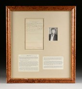
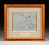
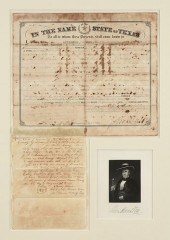 A STATE OF TEXAS LAND GRANT, SIGNED
 BY GOVERNOR SAM HOU...A STATE OF TEXAS LAND GRANT, SIGNED BY GOVERNOR SAM HOUSTON, AUSTIN, 1860, State of Texas printed and hand manuscript completed land grant, Austin, Texas, September 3, 1860, granting to Frederick Liebensan 320 acres in Jones County west side of ... (illegible), lower right Houston's bold signature, 14 3/4" x 11 1/2"; above a docket manuscript document written by Irving Moore, Clerk for the District Court, Brown County, Texas. Framed and matted, enclosing an engraved portrait of Houston with printed signature. Note: Sam Houston (1793-1863), a respected statesman, congressman, a politician trusted by many including some Native Americans, a soldier in the War of 1812 against Britain and a victorious General leading the Texians at the Battle of San Jacinto during the Texas Revolution, served two separate terms as President of the Republic of Texas, had been governor of Tennessee and was the last governor of the State of Texas and only United States southern governor before the Civil War began who opposed joining the Confederacy. Just over six months of signing this document on September 3rd 1860, Sam Houston was pushed out of the Texas governor's seat on March 16, 1861 for his steadfast refusal to swear a loyalty oath to the Confederate States of America. Provenance: Property from a Corporate Collection, Houston, Texas. Condition: Good condition for Texas documents of this age and use including but not limited to ink blooming and bleeding of written text, creases, folds, age darkening of paper, discolorations and some normal small tears along edges. Simpson Galleries strongly encourages in-person inspection of items by the bidder. Statements by Simpson Galleries regarding the condition of objects are for guidance only and should not be relied upon as statements of fact and do not constitute a representation, warranty, or assumption of liability by Simpson Galleries. All lots offered are sold "AS IS."
A STATE OF TEXAS LAND GRANT, SIGNED
A STATE OF TEXAS LAND GRANT, SIGNED BY GOVERNOR SAM HOU...A STATE OF TEXAS LAND GRANT, SIGNED BY GOVERNOR SAM HOUSTON, AUSTIN, 1860, State of Texas printed and hand manuscript completed land grant, Austin, Texas, September 3, 1860, granting to Frederick Liebensan 320 acres in Jones County west side of ... (illegible), lower right Houston's bold signature, 14 3/4" x 11 1/2"; above a docket manuscript document written by Irving Moore, Clerk for the District Court, Brown County, Texas. Framed and matted, enclosing an engraved portrait of Houston with printed signature. Note: Sam Houston (1793-1863), a respected statesman, congressman, a politician trusted by many including some Native Americans, a soldier in the War of 1812 against Britain and a victorious General leading the Texians at the Battle of San Jacinto during the Texas Revolution, served two separate terms as President of the Republic of Texas, had been governor of Tennessee and was the last governor of the State of Texas and only United States southern governor before the Civil War began who opposed joining the Confederacy. Just over six months of signing this document on September 3rd 1860, Sam Houston was pushed out of the Texas governor's seat on March 16, 1861 for his steadfast refusal to swear a loyalty oath to the Confederate States of America. Provenance: Property from a Corporate Collection, Houston, Texas. Condition: Good condition for Texas documents of this age and use including but not limited to ink blooming and bleeding of written text, creases, folds, age darkening of paper, discolorations and some normal small tears along edges. Simpson Galleries strongly encourages in-person inspection of items by the bidder. Statements by Simpson Galleries regarding the condition of objects are for guidance only and should not be relied upon as statements of fact and do not constitute a representation, warranty, or assumption of liability by Simpson Galleries. All lots offered are sold "AS IS." -
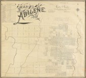 AN ANTIQUE MAP, "MAP OF ABILENE,"
 GALVESTON, 1881-1883,...AN ANTIQUE MAP, "Map of Abilene," GALVESTON, 1881-1883, lithograph on paper, drawn by A.H. Kirby, compiled by J. A. Thomas, printed by Clark & Courts, Galveston, Texas, and published for Carter & Carter: Land, Loans & Stock. 23 1/2" x 25 1/4" Note: "...When the Texas & Pacific Railway began to push westward in 1880, several ranchers and businessmen, including Claiborne W. Merchant, John Merchant, John N. Simpson, John T. Berry, and S. L. Chalk, met with H. C. Whithers, the Texas & Pacific track and townsite locator, and arranged to have the railroad bypass Buffalo Gap, the current County Seat. They agreed that the route would traverse lands which the group owned in the northern part of the county, and that a new town would be established between Cedar and Big Elm creeks east of Catclaw Creek. C. W. Merchant apparently suggested the name Abilene, after the Kansas cattle town....The Texas and Pacific arrived at the site in January 1881 the railroad promoted Abilene as the "Future Great City of West Texas." J. Stoddard Johnston and other railroad officials platted the townsite. Several hundred people arrived in Abilene before the sale of town lots and began to establish businesses and a church. The lots were auctioned on March 15, 1881; in two days buyers purchased more than 300 lots, and Abilene was officially established. On January 2, 1883, the residents voted to incorporate, and in an election held on October 23, 1883, Abilene became the county seat. ..The map was published by Clarke & Courts, on what is believed to be the oldest lithographic printing press in the State of Texas. Clarke and Courts traces its roots to M. Strickland and Company, organized at Galveston by Miles Strickland in 1857. Strickland moved his printing press to Houston, but subsequently returned to Galveston. Robert Clarke became a partner in the firm in 1870. In 1877, George M. Courts purchased Strickland's interest. In 1877, the two printers brought the first lithograph press in the state to Galveston..." Courtesy: Barry Lawrence Ruderman Antique Maps Inc. Provenance: Property from a Fortune 500 Energy Company, Houston, Texas. Condition: Some tears, creases throughout, apparent repairs, but overall in good to very good condition, wear commensurate with age and use. Simpson Galleries strongly encourages in-person inspection of items by the bidder. Statements by Simpson Galleries regarding the condition of objects are for guidance only and should not be relied upon as statements of fact and do not constitute a representation, warranty, or assumption of liability by Simpson Galleries. All lots offered are sold "AS IS."
AN ANTIQUE MAP, "MAP OF ABILENE,"
AN ANTIQUE MAP, "MAP OF ABILENE," GALVESTON, 1881-1883,...AN ANTIQUE MAP, "Map of Abilene," GALVESTON, 1881-1883, lithograph on paper, drawn by A.H. Kirby, compiled by J. A. Thomas, printed by Clark & Courts, Galveston, Texas, and published for Carter & Carter: Land, Loans & Stock. 23 1/2" x 25 1/4" Note: "...When the Texas & Pacific Railway began to push westward in 1880, several ranchers and businessmen, including Claiborne W. Merchant, John Merchant, John N. Simpson, John T. Berry, and S. L. Chalk, met with H. C. Whithers, the Texas & Pacific track and townsite locator, and arranged to have the railroad bypass Buffalo Gap, the current County Seat. They agreed that the route would traverse lands which the group owned in the northern part of the county, and that a new town would be established between Cedar and Big Elm creeks east of Catclaw Creek. C. W. Merchant apparently suggested the name Abilene, after the Kansas cattle town....The Texas and Pacific arrived at the site in January 1881 the railroad promoted Abilene as the "Future Great City of West Texas." J. Stoddard Johnston and other railroad officials platted the townsite. Several hundred people arrived in Abilene before the sale of town lots and began to establish businesses and a church. The lots were auctioned on March 15, 1881; in two days buyers purchased more than 300 lots, and Abilene was officially established. On January 2, 1883, the residents voted to incorporate, and in an election held on October 23, 1883, Abilene became the county seat. ..The map was published by Clarke & Courts, on what is believed to be the oldest lithographic printing press in the State of Texas. Clarke and Courts traces its roots to M. Strickland and Company, organized at Galveston by Miles Strickland in 1857. Strickland moved his printing press to Houston, but subsequently returned to Galveston. Robert Clarke became a partner in the firm in 1870. In 1877, George M. Courts purchased Strickland's interest. In 1877, the two printers brought the first lithograph press in the state to Galveston..." Courtesy: Barry Lawrence Ruderman Antique Maps Inc. Provenance: Property from a Fortune 500 Energy Company, Houston, Texas. Condition: Some tears, creases throughout, apparent repairs, but overall in good to very good condition, wear commensurate with age and use. Simpson Galleries strongly encourages in-person inspection of items by the bidder. Statements by Simpson Galleries regarding the condition of objects are for guidance only and should not be relied upon as statements of fact and do not constitute a representation, warranty, or assumption of liability by Simpson Galleries. All lots offered are sold "AS IS." -
 A CIVIL WAR ERA ANTIQUE MAP,
 "JOHNSON'S NEW MAP OF THE ...A CIVIL WAR ERA ANTIQUE MAP, "Johnson's New Map of the State Of Texas," NEW YORK, 1860-1863, hand colored engraving on paper, page fragments from an atlas, plates no. 43-44, with inset plans of "Sabine River," "Galveston Bay," and of the "Northern Part of Texas," the whole enclosed within a border of heraldic swag curled around banner poles, published by Johnson & Ward. 17" x 25 1/4" Provenance: Property from a Fortune 500 Energy Company, Houston, Texas. Condition: Toning, some foxing spots, fading of watercolor, some waving of paper, but overall in good to very good condition, wear commensurate with age and use. Simpson Galleries strongly encourages in-person inspection of items by the bidder. Statements by Simpson Galleries regarding the condition of objects are for guidance only and should not be relied upon as statements of fact and do not constitute a representation, warranty, or assumption of liability by Simpson Galleries. All lots offered are sold "AS IS."
A CIVIL WAR ERA ANTIQUE MAP,
A CIVIL WAR ERA ANTIQUE MAP, "JOHNSON'S NEW MAP OF THE ...A CIVIL WAR ERA ANTIQUE MAP, "Johnson's New Map of the State Of Texas," NEW YORK, 1860-1863, hand colored engraving on paper, page fragments from an atlas, plates no. 43-44, with inset plans of "Sabine River," "Galveston Bay," and of the "Northern Part of Texas," the whole enclosed within a border of heraldic swag curled around banner poles, published by Johnson & Ward. 17" x 25 1/4" Provenance: Property from a Fortune 500 Energy Company, Houston, Texas. Condition: Toning, some foxing spots, fading of watercolor, some waving of paper, but overall in good to very good condition, wear commensurate with age and use. Simpson Galleries strongly encourages in-person inspection of items by the bidder. Statements by Simpson Galleries regarding the condition of objects are for guidance only and should not be relied upon as statements of fact and do not constitute a representation, warranty, or assumption of liability by Simpson Galleries. All lots offered are sold "AS IS." -
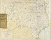 AN ANTIQUE MAP, "UNITED STATES
 (SOUTH CENTRAL)," LIVERP...AN ANTIQUE MAP, "United States (South Central)," LIVERPOOL, GREAT BRITAIN, 1891-1917, a color engraving on paper,"Philips' Authentic Imperial Maps for Tourists and Travelers," printed by George Philip & Son, The London Geographical Institute, contributor; a good map of the State of Texas with local special interest historic neighborhoods such as Houston Heights, Park Place, Harrisburg, Katy and others, showing principal railroad routes in red. 21" x 26" Provenance: Property from a Fortune 500 Energy Company, Houston, Texas. Condition: Some creases as issued, Northern Mexico and Baja California are concealed by original cover, some tears, but overall in very good condition, wear commensurate with age and use. Simpson Galleries strongly encourages in-person inspection of items by the bidder. Statements by Simpson Galleries regarding the condition of objects are for guidance only and should not be relied upon as statements of fact and do not constitute a representation, warranty, or assumption of liability by Simpson Galleries. All lots offered are sold "AS IS."
AN ANTIQUE MAP, "UNITED STATES
AN ANTIQUE MAP, "UNITED STATES (SOUTH CENTRAL)," LIVERP...AN ANTIQUE MAP, "United States (South Central)," LIVERPOOL, GREAT BRITAIN, 1891-1917, a color engraving on paper,"Philips' Authentic Imperial Maps for Tourists and Travelers," printed by George Philip & Son, The London Geographical Institute, contributor; a good map of the State of Texas with local special interest historic neighborhoods such as Houston Heights, Park Place, Harrisburg, Katy and others, showing principal railroad routes in red. 21" x 26" Provenance: Property from a Fortune 500 Energy Company, Houston, Texas. Condition: Some creases as issued, Northern Mexico and Baja California are concealed by original cover, some tears, but overall in very good condition, wear commensurate with age and use. Simpson Galleries strongly encourages in-person inspection of items by the bidder. Statements by Simpson Galleries regarding the condition of objects are for guidance only and should not be relied upon as statements of fact and do not constitute a representation, warranty, or assumption of liability by Simpson Galleries. All lots offered are sold "AS IS." -
 AN ANTIQUE COURT DOCUMENT,
 INDICTING SAM HOUSTON'S SON,...AN ANTIQUE COURT DOCUMENT, INDICTING SAM HOUSTON'S SON, TEMPLE HOUSTON, ARMSTRONG COUNTY, FEBRUARY 26TH 1894, hand inscribed ink and lithograph on paper, signed by W.M. Warren, Foreman of the Grand Jury, "...IN THE NAME AND BY THE AUTHORITY OF THE STATE OF TEXAS, The Grand Jurors...present that 'in a public place and not at a private residence did unlawfully bet at a game called poker dice played with dice named in the Statute." 13 3/4" x 8 1/4" Provenance: Property from a Corporate Collection, Houston, Texas. Property from a Corporate Collection, Houston, Texas Condition: Some creases as issued and some handling creases, toning, overall in good to very good condition, wear commensurate with age. Simpson Galleries strongly encourages in-person inspection of items by the bidder. Statements by Simpson Galleries regarding the condition of objects are for guidance only and should not be relied upon as statements of fact and do not constitute a representation, warranty, or assumption of liability by Simpson Galleries. All lots offered are sold "AS IS.” NO REFUNDS will be issued based on condition.
AN ANTIQUE COURT DOCUMENT,
AN ANTIQUE COURT DOCUMENT, INDICTING SAM HOUSTON'S SON,...AN ANTIQUE COURT DOCUMENT, INDICTING SAM HOUSTON'S SON, TEMPLE HOUSTON, ARMSTRONG COUNTY, FEBRUARY 26TH 1894, hand inscribed ink and lithograph on paper, signed by W.M. Warren, Foreman of the Grand Jury, "...IN THE NAME AND BY THE AUTHORITY OF THE STATE OF TEXAS, The Grand Jurors...present that 'in a public place and not at a private residence did unlawfully bet at a game called poker dice played with dice named in the Statute." 13 3/4" x 8 1/4" Provenance: Property from a Corporate Collection, Houston, Texas. Property from a Corporate Collection, Houston, Texas Condition: Some creases as issued and some handling creases, toning, overall in good to very good condition, wear commensurate with age. Simpson Galleries strongly encourages in-person inspection of items by the bidder. Statements by Simpson Galleries regarding the condition of objects are for guidance only and should not be relied upon as statements of fact and do not constitute a representation, warranty, or assumption of liability by Simpson Galleries. All lots offered are sold "AS IS.” NO REFUNDS will be issued based on condition. -
 AN ANTIQUE AMBASSADORIAL
 DOCUMENT, SIGNED BY PRESIDENT ...AN ANTIQUE AMBASSADORIAL DOCUMENT, SIGNED BY PRESIDENT CHESTER A. ARTHUR, RECOGNIZING WALTER TSCHUDI LYALL AS BRITISH CONSUL OF THE STATE OF TEXAS, WASHINGTON, D.C., JULY 11, 1884, hand inscribed lithograph on paper, signed L/R by the President, "Chester A. Arthur," and L/L signed by Secretary of State, "Fred K. T. Frelinghuysen," and with applied seal, recognizing British Consul to serve in Galveston, Texas. 18 3/4" x 22 3/4" Provenance: Property from a Corporate Collection, Houston, Texas. Property from a Corporate Collection, Houston, Texas Condition: Some foxing, yellowing, handling creases, a spot at lower right, creases as issued, some fading of ink, overall in good condition, wear commensurate with age. Simpson Galleries strongly encourages in-person inspection of items by the bidder. Statements by Simpson Galleries regarding the condition of objects are for guidance only and should not be relied upon as statements of fact and do not constitute a representation, warranty, or assumption of liability by Simpson Galleries. All lots offered are sold "AS IS.” NO REFUNDS will be issued based on condition.
AN ANTIQUE AMBASSADORIAL
AN ANTIQUE AMBASSADORIAL DOCUMENT, SIGNED BY PRESIDENT ...AN ANTIQUE AMBASSADORIAL DOCUMENT, SIGNED BY PRESIDENT CHESTER A. ARTHUR, RECOGNIZING WALTER TSCHUDI LYALL AS BRITISH CONSUL OF THE STATE OF TEXAS, WASHINGTON, D.C., JULY 11, 1884, hand inscribed lithograph on paper, signed L/R by the President, "Chester A. Arthur," and L/L signed by Secretary of State, "Fred K. T. Frelinghuysen," and with applied seal, recognizing British Consul to serve in Galveston, Texas. 18 3/4" x 22 3/4" Provenance: Property from a Corporate Collection, Houston, Texas. Property from a Corporate Collection, Houston, Texas Condition: Some foxing, yellowing, handling creases, a spot at lower right, creases as issued, some fading of ink, overall in good condition, wear commensurate with age. Simpson Galleries strongly encourages in-person inspection of items by the bidder. Statements by Simpson Galleries regarding the condition of objects are for guidance only and should not be relied upon as statements of fact and do not constitute a representation, warranty, or assumption of liability by Simpson Galleries. All lots offered are sold "AS IS.” NO REFUNDS will be issued based on condition. -
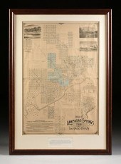 AN ANTIQUE MAP, "MAP OF LAMPASAS
 SPRINGS, TEXAS, LAMPAS...AN ANTIQUE MAP, "Map of Lampasas Springs, Texas, Lampasas County," DALLAS, CIRCA 1884, hand colored lithograph on paper with manuscript, published for Central Town Company, Dallas Lithograph Co., lithographers, Hannah Park, Spring and Pavilion plot ink inscribed, "Cost $14,000," showing planned and subdivided land plots, the Lampasas & LLano Railroad and the Gulf, Colorado & Santa Fe Railroads run through town, at top inset views of the Pool at Hanna Park, Park Hotel, and the Bathhouse at Hancock Springs; at lower right an inset "Map of the State of Texas," overlaid with concentric distance chart centering Lampasas, a promotional map inviting settlement, claiming, "Lampasas is destined to be the manufacturing city and distributing point of Central Texas," and that the city is also, "...free from malaria.," advertising natural springs, mineable minerals and natural resources such as marble to potential investors and residents. 42" x 28 1/2" Provenance: Property from a Corporate Collection, Houston, Texas. Property from a Corporate Collection, Houston, Texas Condition: Some creases as issued, handling creasing, small tears and damages, stains, fading of hand color, ink inscription, overall in good to very good condition, wear commensurate with age. Simpson Galleries strongly encourages in-person inspection of items by the bidder. Statements by Simpson Galleries regarding the condition of objects are for guidance only and should not be relied upon as statements of fact and do not constitute a representation, warranty, or assumption of liability by Simpson Galleries. All lots offered are sold "AS IS.” NO REFUNDS will be issued based on condition.
AN ANTIQUE MAP, "MAP OF LAMPASAS
AN ANTIQUE MAP, "MAP OF LAMPASAS SPRINGS, TEXAS, LAMPAS...AN ANTIQUE MAP, "Map of Lampasas Springs, Texas, Lampasas County," DALLAS, CIRCA 1884, hand colored lithograph on paper with manuscript, published for Central Town Company, Dallas Lithograph Co., lithographers, Hannah Park, Spring and Pavilion plot ink inscribed, "Cost $14,000," showing planned and subdivided land plots, the Lampasas & LLano Railroad and the Gulf, Colorado & Santa Fe Railroads run through town, at top inset views of the Pool at Hanna Park, Park Hotel, and the Bathhouse at Hancock Springs; at lower right an inset "Map of the State of Texas," overlaid with concentric distance chart centering Lampasas, a promotional map inviting settlement, claiming, "Lampasas is destined to be the manufacturing city and distributing point of Central Texas," and that the city is also, "...free from malaria.," advertising natural springs, mineable minerals and natural resources such as marble to potential investors and residents. 42" x 28 1/2" Provenance: Property from a Corporate Collection, Houston, Texas. Property from a Corporate Collection, Houston, Texas Condition: Some creases as issued, handling creasing, small tears and damages, stains, fading of hand color, ink inscription, overall in good to very good condition, wear commensurate with age. Simpson Galleries strongly encourages in-person inspection of items by the bidder. Statements by Simpson Galleries regarding the condition of objects are for guidance only and should not be relied upon as statements of fact and do not constitute a representation, warranty, or assumption of liability by Simpson Galleries. All lots offered are sold "AS IS.” NO REFUNDS will be issued based on condition. -
 AN ANTIQUE RECONSTRUCTION ERA
 MAP, "NEW MAP OF TEXAS PR...AN ANTIQUE RECONSTRUCTION ERA MAP, "New Map of Texas Prepared and Published for the Bureau of Immigration of the State of Texas," NEW YORK, 1875, color cerography on paper, "By A.R. Roessler, Civil and Mining Engineer, 52 Beekman Street, New York, 1875," with a chart lower left identifying railroad stations and their exact coordinates, a cartouche containing an architectural rendering of the second "State Capitol at Austin," above "Explanations," listing "Iron, Manganese, Copper, Silverlead, Gold, Bismuth, Molybdenite, Copperas, Sulphur, Salt, Gypsum, Coal, Lignite, Graphite, Kaolin, Potters clay, Steatite, Mica, Feldspar, Mineral asphalt and the Boundary of Timber and Prairie," above an explanation of Texan geology. 15" x 17" Note: "The lower and rolling lands are alluvial and tertiary. The hilly region is cretaceous. Primitive rocks appear in many places. The great Plains consist of stratified clay and cretaceous marks. On the verge of these plains are deposits of Gypsum extending over an area of thousands of square miles. Coal beds of carboniferous age exist in the North West. Iron Ores in inexhaustible quantities on LLano & Colorado Rivers and Tributaries of Red River; silverlead and copperlance in the North West; salt at Salt Springs and by natural evaporation on the lakes." Provenance: Property from a Corporate Collection, Houston, Texas. Property from a Corporate Collection, Houston, Texas Condition: Some losses, toning, repairs, losses at neatline, uneven edges, overall in good to very good condition, wear commensurate with age. Simpson Galleries strongly encourages in-person inspection of items by the bidder. Statements by Simpson Galleries regarding the condition of objects are for guidance only and should not be relied upon as statements of fact and do not constitute a representation, warranty, or assumption of liability by Simpson Galleries. All lots offered are sold "AS IS.” NO REFUNDS will be issued based on condition.
AN ANTIQUE RECONSTRUCTION ERA
AN ANTIQUE RECONSTRUCTION ERA MAP, "NEW MAP OF TEXAS PR...AN ANTIQUE RECONSTRUCTION ERA MAP, "New Map of Texas Prepared and Published for the Bureau of Immigration of the State of Texas," NEW YORK, 1875, color cerography on paper, "By A.R. Roessler, Civil and Mining Engineer, 52 Beekman Street, New York, 1875," with a chart lower left identifying railroad stations and their exact coordinates, a cartouche containing an architectural rendering of the second "State Capitol at Austin," above "Explanations," listing "Iron, Manganese, Copper, Silverlead, Gold, Bismuth, Molybdenite, Copperas, Sulphur, Salt, Gypsum, Coal, Lignite, Graphite, Kaolin, Potters clay, Steatite, Mica, Feldspar, Mineral asphalt and the Boundary of Timber and Prairie," above an explanation of Texan geology. 15" x 17" Note: "The lower and rolling lands are alluvial and tertiary. The hilly region is cretaceous. Primitive rocks appear in many places. The great Plains consist of stratified clay and cretaceous marks. On the verge of these plains are deposits of Gypsum extending over an area of thousands of square miles. Coal beds of carboniferous age exist in the North West. Iron Ores in inexhaustible quantities on LLano & Colorado Rivers and Tributaries of Red River; silverlead and copperlance in the North West; salt at Salt Springs and by natural evaporation on the lakes." Provenance: Property from a Corporate Collection, Houston, Texas. Property from a Corporate Collection, Houston, Texas Condition: Some losses, toning, repairs, losses at neatline, uneven edges, overall in good to very good condition, wear commensurate with age. Simpson Galleries strongly encourages in-person inspection of items by the bidder. Statements by Simpson Galleries regarding the condition of objects are for guidance only and should not be relied upon as statements of fact and do not constitute a representation, warranty, or assumption of liability by Simpson Galleries. All lots offered are sold "AS IS.” NO REFUNDS will be issued based on condition. -
 AN ANTIQUE MAP, "A.R. ROESSLER'S
 LATEST MAP OF THE STAT...AN ANTIQUE MAP, "A.R. Roessler's Latest Map of the State of Texas," NEW YORK, 1874, hand colored lithograph on paper, "Compiled and Drawn by M.V. Mittendorfer, C.E.," published by "ED. W. Welke & Bro.141 Fulton St. NY.," and "Entered according to Act of Congress in the year 1874 by A. R. Roessler in the Office of the Librarian of Congress at Washington.," the title with a lone star seal, an engraved view of the second State Capitol of Texas used 1853-1881, the Gulf of Mexico has a list of "Explanations," including State Capitol, Post Offices and routes with frequency of once, twice and three times a week, natural mineral deposits, various trees, swamps, and at left an, "Enumeration of the Principal Minerals, Rocks, Soils, and Timber Varieties known to exist in the State of Texas, Arranged According to Counties.," with an inset, "Map Showing Agricultural Districts and Varieties of Soils in the State of Texas," framed with a gilt embossed leather front board. 38" x 43" Note: The large format map is known to preserve the first geological and agricultural data recorded about Texas soil on the Shumard Survey, which would have been otherwise lost during the Civil War. Resource: Taliaferro, Cartographic Sources in the Rosenberg Library, 349. Provenance: Property from a Corporate Collection, Houston, Texas. Property from a Corporate Collection, Houston, Texas Condition: Some losses at creases, mostly in North Texas, some fading of hand color, stains, buckles, some backed and inpainted/drawn repairs, expected handling creases, overall in good to very good condition, wear commensurate with age. Simpson Galleries strongly encourages in-person inspection of items by the bidder. Statements by Simpson Galleries regarding the condition of objects are for guidance only and should not be relied upon as statements of fact and do not constitute a representation, warranty, or assumption of liability by Simpson Galleries. All lots offered are sold "AS IS.” NO REFUNDS will be issued based on condition.
AN ANTIQUE MAP, "A.R. ROESSLER'S
AN ANTIQUE MAP, "A.R. ROESSLER'S LATEST MAP OF THE STAT...AN ANTIQUE MAP, "A.R. Roessler's Latest Map of the State of Texas," NEW YORK, 1874, hand colored lithograph on paper, "Compiled and Drawn by M.V. Mittendorfer, C.E.," published by "ED. W. Welke & Bro.141 Fulton St. NY.," and "Entered according to Act of Congress in the year 1874 by A. R. Roessler in the Office of the Librarian of Congress at Washington.," the title with a lone star seal, an engraved view of the second State Capitol of Texas used 1853-1881, the Gulf of Mexico has a list of "Explanations," including State Capitol, Post Offices and routes with frequency of once, twice and three times a week, natural mineral deposits, various trees, swamps, and at left an, "Enumeration of the Principal Minerals, Rocks, Soils, and Timber Varieties known to exist in the State of Texas, Arranged According to Counties.," with an inset, "Map Showing Agricultural Districts and Varieties of Soils in the State of Texas," framed with a gilt embossed leather front board. 38" x 43" Note: The large format map is known to preserve the first geological and agricultural data recorded about Texas soil on the Shumard Survey, which would have been otherwise lost during the Civil War. Resource: Taliaferro, Cartographic Sources in the Rosenberg Library, 349. Provenance: Property from a Corporate Collection, Houston, Texas. Property from a Corporate Collection, Houston, Texas Condition: Some losses at creases, mostly in North Texas, some fading of hand color, stains, buckles, some backed and inpainted/drawn repairs, expected handling creases, overall in good to very good condition, wear commensurate with age. Simpson Galleries strongly encourages in-person inspection of items by the bidder. Statements by Simpson Galleries regarding the condition of objects are for guidance only and should not be relied upon as statements of fact and do not constitute a representation, warranty, or assumption of liability by Simpson Galleries. All lots offered are sold "AS IS.” NO REFUNDS will be issued based on condition. -
 AN ANTIQUE RECONSTRUCTION ERA
 MAP, "TRAVELLER'S MAP OF ...AN ANTIQUE RECONSTRUCTION ERA MAP, "Traveller's Map of the State of Texas," CHARLES M. PRESSLER, NEW YORK, CIRCA 1867, photolithograph with color on paper, "Compiled from the records of the General Land Office, the maps of the Coast Survey, the reports of the Boundary Commission and various other Military surveys and reconnoissances by Chas. M. Pressler," the map retailed by, "Levinson Perkins & Co., No. 80 Beaver Street, New York," in the lower right margin, "Entered According to the Act of Congress in the year 1868 by Chas. W. Pressler in the Clerk's Office of the District Court of the United States Court for the Southern District of New York.," in the central margin noted as published by the "American Photolithographic Company, New York (Osborne's Process)," with inset view, "Map of the Western Part of Texas," topographical elevation shown in hachures, showing the State Capitol, County Seats, villages, Post Offices, railroads, common roads, and bayous (incorrectly printed "Bayon"), lighthouses, trading posts, military forts, Indian territory, the "Immigrant's Road to California," noted with water sources for travelers, and occupied Comanche and Kiowa lands. 41 1/2" x 40" Note: This map is a second revision by Pressler of, "Map of the State of Texas," originally published by James Root & Company in 1858. Both an actual surveyor and compiler of maps and surveillance data, Charles W. Pressler's attention to detail and first-hand knowledge cultivated a tradition of accuracy and dependability unsurpassed by his cartographic colleagues. The data that was recorded and compiled before, during, and after the American Civil War is expertly present herein, authoritatively defining the mid 19th century Texas landscape during the Reconstruction era. Provenance: Property from a Corporate Collection, Houston, Texas. Property from a Corporate Collection, Houston, Texas Condition: Some toning, stains, mild foxing, losses mostly near creases and edges, with repairs and minimal inpainting/drawing, some buckling, and adhesive ghosting at neat line, backed, some fading of color, repairs are aging, overall in good condition, wear commensurate with age. Simpson Galleries strongly encourages in-person inspection of items by the bidder. Statements by Simpson Galleries regarding the condition of objects are for guidance only and should not be relied upon as statements of fact and do not constitute a representation, warranty, or assumption of liability by Simpson Galleries. All lots offered are sold "AS IS.” NO REFUNDS will be issued based on condition.
AN ANTIQUE RECONSTRUCTION ERA
AN ANTIQUE RECONSTRUCTION ERA MAP, "TRAVELLER'S MAP OF ...AN ANTIQUE RECONSTRUCTION ERA MAP, "Traveller's Map of the State of Texas," CHARLES M. PRESSLER, NEW YORK, CIRCA 1867, photolithograph with color on paper, "Compiled from the records of the General Land Office, the maps of the Coast Survey, the reports of the Boundary Commission and various other Military surveys and reconnoissances by Chas. M. Pressler," the map retailed by, "Levinson Perkins & Co., No. 80 Beaver Street, New York," in the lower right margin, "Entered According to the Act of Congress in the year 1868 by Chas. W. Pressler in the Clerk's Office of the District Court of the United States Court for the Southern District of New York.," in the central margin noted as published by the "American Photolithographic Company, New York (Osborne's Process)," with inset view, "Map of the Western Part of Texas," topographical elevation shown in hachures, showing the State Capitol, County Seats, villages, Post Offices, railroads, common roads, and bayous (incorrectly printed "Bayon"), lighthouses, trading posts, military forts, Indian territory, the "Immigrant's Road to California," noted with water sources for travelers, and occupied Comanche and Kiowa lands. 41 1/2" x 40" Note: This map is a second revision by Pressler of, "Map of the State of Texas," originally published by James Root & Company in 1858. Both an actual surveyor and compiler of maps and surveillance data, Charles W. Pressler's attention to detail and first-hand knowledge cultivated a tradition of accuracy and dependability unsurpassed by his cartographic colleagues. The data that was recorded and compiled before, during, and after the American Civil War is expertly present herein, authoritatively defining the mid 19th century Texas landscape during the Reconstruction era. Provenance: Property from a Corporate Collection, Houston, Texas. Property from a Corporate Collection, Houston, Texas Condition: Some toning, stains, mild foxing, losses mostly near creases and edges, with repairs and minimal inpainting/drawing, some buckling, and adhesive ghosting at neat line, backed, some fading of color, repairs are aging, overall in good condition, wear commensurate with age. Simpson Galleries strongly encourages in-person inspection of items by the bidder. Statements by Simpson Galleries regarding the condition of objects are for guidance only and should not be relied upon as statements of fact and do not constitute a representation, warranty, or assumption of liability by Simpson Galleries. All lots offered are sold "AS IS.” NO REFUNDS will be issued based on condition. -
 AN ANTIQUE AMBASSADORIAL
 DOCUMENT, SIGNED BY PRESIDENT ...AN ANTIQUE AMBASSADORIAL DOCUMENT, SIGNED BY PRESIDENT GROVER CLEVELAND RECOGNIZING WALTER TSCHUDI LYALL AS BRITISH CONSUL OF THE STATE OF TEXAS AND FOR THE TERRITORY OF NEW MEXICO, WASHINGTON, D.C., AUGUST 4, 1886, hand inscribed lithograph on paper, signed L/R by the President, "Grover Cleveland," and L/L Thomas F. Bayard, Secretary of State signs, "T. F Bayard," and a large embossed Presidential seal. 18 3/4" x 22 3/4" Provenance: Property from a Corporate Collection, Houston, Texas. Property from a Corporate Collection, Houston, Texas Condition: Some toning, handling creases, creases as issued, expected wear, overall in good to very good condition, wear commensurate with age and use. Simpson Galleries strongly encourages in-person inspection of items by the bidder. Statements by Simpson Galleries regarding the condition of objects are for guidance only and should not be relied upon as statements of fact and do not constitute a representation, warranty, or assumption of liability by Simpson Galleries. All lots offered are sold "AS IS.” NO REFUNDS will be issued based on condition.
AN ANTIQUE AMBASSADORIAL
AN ANTIQUE AMBASSADORIAL DOCUMENT, SIGNED BY PRESIDENT ...AN ANTIQUE AMBASSADORIAL DOCUMENT, SIGNED BY PRESIDENT GROVER CLEVELAND RECOGNIZING WALTER TSCHUDI LYALL AS BRITISH CONSUL OF THE STATE OF TEXAS AND FOR THE TERRITORY OF NEW MEXICO, WASHINGTON, D.C., AUGUST 4, 1886, hand inscribed lithograph on paper, signed L/R by the President, "Grover Cleveland," and L/L Thomas F. Bayard, Secretary of State signs, "T. F Bayard," and a large embossed Presidential seal. 18 3/4" x 22 3/4" Provenance: Property from a Corporate Collection, Houston, Texas. Property from a Corporate Collection, Houston, Texas Condition: Some toning, handling creases, creases as issued, expected wear, overall in good to very good condition, wear commensurate with age and use. Simpson Galleries strongly encourages in-person inspection of items by the bidder. Statements by Simpson Galleries regarding the condition of objects are for guidance only and should not be relied upon as statements of fact and do not constitute a representation, warranty, or assumption of liability by Simpson Galleries. All lots offered are sold "AS IS.” NO REFUNDS will be issued based on condition. -
 AN ANTIQUE CADASTRAL MAP,
 "MONTGOMERY COUNTY, " CIRCA 1...AN ANTIQUE CADASTRAL MAP, "Montgomery County, " CIRCA 1880, lithograph on paper, showing in the east Lake Creek, Mill Creek, Indian Creek, in the west the San Jacinto River, the Houston Great Northern Railroad travels north and south at center, in the south Spring Creek, bordered by Harriss, San Jacinto, Liberty and Grimes counties, "Copyright 1880 W.C. Walsh, Commissioner of the General Land Office of the State of Texas," lower right, "I, W.C. Walsh, Commissioner of the General Land Office, do hereby certify that this is a true and correct copy of the original map now in use in this office compiled from official data," signed in plate. 21 3/8" x 24 1/2" Provenance: Property from a Corporate Collection, Houston, Texas. Property from a Corporate Collection, Houston, Texas Condition: Mild tone, linen backed, handling and mild creases, some losses, overall in good to very good condition, wear commensurate with age. Simpson Galleries strongly encourages in-person inspection of items by the bidder. Statements by Simpson Galleries regarding the condition of objects are for guidance only and should not be relied upon as statements of fact and do not constitute a representation, warranty, or assumption of liability by Simpson Galleries. All lots offered are sold "AS IS.” NO REFUNDS will be issued based on condition.
AN ANTIQUE CADASTRAL MAP,
AN ANTIQUE CADASTRAL MAP, "MONTGOMERY COUNTY, " CIRCA 1...AN ANTIQUE CADASTRAL MAP, "Montgomery County, " CIRCA 1880, lithograph on paper, showing in the east Lake Creek, Mill Creek, Indian Creek, in the west the San Jacinto River, the Houston Great Northern Railroad travels north and south at center, in the south Spring Creek, bordered by Harriss, San Jacinto, Liberty and Grimes counties, "Copyright 1880 W.C. Walsh, Commissioner of the General Land Office of the State of Texas," lower right, "I, W.C. Walsh, Commissioner of the General Land Office, do hereby certify that this is a true and correct copy of the original map now in use in this office compiled from official data," signed in plate. 21 3/8" x 24 1/2" Provenance: Property from a Corporate Collection, Houston, Texas. Property from a Corporate Collection, Houston, Texas Condition: Mild tone, linen backed, handling and mild creases, some losses, overall in good to very good condition, wear commensurate with age. Simpson Galleries strongly encourages in-person inspection of items by the bidder. Statements by Simpson Galleries regarding the condition of objects are for guidance only and should not be relied upon as statements of fact and do not constitute a representation, warranty, or assumption of liability by Simpson Galleries. All lots offered are sold "AS IS.” NO REFUNDS will be issued based on condition. -
 A TEXAS COURT DOCUMENT, SIGNED BY
 SAM HOUSTON, "SAM HOU...A TEXAS COURT DOCUMENT, SIGNED BY SAM HOUSTON, "Sam Houston VS. James H. Starr," NACOGDOCHES, NOVEMBER 10, 1855, hand inscribed ink on blue paper, "The State of Texas, Nacogdoches County, District Fall Term 1855," signed by Sam Houston at back. 12" x 15 1/4" Provenance: Property from a Corporate Collection, Houston, Texas. Property from a Corporate Collection, Houston, Texas Condition: Some stains, transfer, tears at creases, dual view frame, overall in good condition, wear commensurate with age. Simpson Galleries strongly encourages in-person inspection of items by the bidder. Statements by Simpson Galleries regarding the condition of objects are for guidance only and should not be relied upon as statements of fact and do not constitute a representation, warranty, or assumption of liability by Simpson Galleries. All lots offered are sold "AS IS.” NO REFUNDS will be issued based on condition.
A TEXAS COURT DOCUMENT, SIGNED BY
A TEXAS COURT DOCUMENT, SIGNED BY SAM HOUSTON, "SAM HOU...A TEXAS COURT DOCUMENT, SIGNED BY SAM HOUSTON, "Sam Houston VS. James H. Starr," NACOGDOCHES, NOVEMBER 10, 1855, hand inscribed ink on blue paper, "The State of Texas, Nacogdoches County, District Fall Term 1855," signed by Sam Houston at back. 12" x 15 1/4" Provenance: Property from a Corporate Collection, Houston, Texas. Property from a Corporate Collection, Houston, Texas Condition: Some stains, transfer, tears at creases, dual view frame, overall in good condition, wear commensurate with age. Simpson Galleries strongly encourages in-person inspection of items by the bidder. Statements by Simpson Galleries regarding the condition of objects are for guidance only and should not be relied upon as statements of fact and do not constitute a representation, warranty, or assumption of liability by Simpson Galleries. All lots offered are sold "AS IS.” NO REFUNDS will be issued based on condition. -
 AN ANTIQUE CADASTRAL MAP, "MAP OF
 DUVAL CO., GENERAL LA...AN ANTIQUE CADASTRAL MAP, "Map of Duval Co., General Land Office, April 1880, " ST. LOUIS, LATE 19TH CENTURY, lithograph on paper after the original showing the selection of the county seat indicated by a large circle at center, upper right, "Copyright 1879 Wm. C. Walsh, Commissioner, General Land Office," upper left, "I, Wm. C. Walsh, Commissioner, General Land Office, State of Texas, certify this to be a true and correct copy of the map now in use in this office and compiled from official data, Austin, April 1880," and signed in plate, "Lithographed by August Gast & Co.'s New Process, St. Louis," lower right. 29 3/4" x 20 3/4" Note: "Although Duval County was created by the State Legislature in 1858, it was attached to Nueces County until 1876 when a group of citizens petitioned for an organizational election. On February 1, 1858 the legislature passed an act creating: The county of Duval, (named in honor of Captain Burr H. Duval, who fell in Fannin's Massacre), the county seat thereof shall bear the same name, and may be located by a majority vote anywhere within ten miles of its center. The act provided for the county to be organized by a petition of 75 citizens. It was not until 1876 that the petition would come forward." Special thanks to Duval County Texas for a thorough historical public record. Provenance: Property from a Corporate Collection, Houston, Texas. Property from a Corporate Collection, Houston, Texas Condition: Handling and creases, some tone throughout, surface stains, spray and foxing, repaired tears at margins, some abrasive losses, overall in good to very good condition, wear commensurate with age. Simpson Galleries strongly encourages in-person inspection of items by the bidder. Statements by Simpson Galleries regarding the condition of objects are for guidance only and should not be relied upon as statements of fact and do not constitute a representation, warranty, or assumption of liability by Simpson Galleries. All lots offered are sold "AS IS.” NO REFUNDS will be issued based on condition.
AN ANTIQUE CADASTRAL MAP, "MAP OF
AN ANTIQUE CADASTRAL MAP, "MAP OF DUVAL CO., GENERAL LA...AN ANTIQUE CADASTRAL MAP, "Map of Duval Co., General Land Office, April 1880, " ST. LOUIS, LATE 19TH CENTURY, lithograph on paper after the original showing the selection of the county seat indicated by a large circle at center, upper right, "Copyright 1879 Wm. C. Walsh, Commissioner, General Land Office," upper left, "I, Wm. C. Walsh, Commissioner, General Land Office, State of Texas, certify this to be a true and correct copy of the map now in use in this office and compiled from official data, Austin, April 1880," and signed in plate, "Lithographed by August Gast & Co.'s New Process, St. Louis," lower right. 29 3/4" x 20 3/4" Note: "Although Duval County was created by the State Legislature in 1858, it was attached to Nueces County until 1876 when a group of citizens petitioned for an organizational election. On February 1, 1858 the legislature passed an act creating: The county of Duval, (named in honor of Captain Burr H. Duval, who fell in Fannin's Massacre), the county seat thereof shall bear the same name, and may be located by a majority vote anywhere within ten miles of its center. The act provided for the county to be organized by a petition of 75 citizens. It was not until 1876 that the petition would come forward." Special thanks to Duval County Texas for a thorough historical public record. Provenance: Property from a Corporate Collection, Houston, Texas. Property from a Corporate Collection, Houston, Texas Condition: Handling and creases, some tone throughout, surface stains, spray and foxing, repaired tears at margins, some abrasive losses, overall in good to very good condition, wear commensurate with age. Simpson Galleries strongly encourages in-person inspection of items by the bidder. Statements by Simpson Galleries regarding the condition of objects are for guidance only and should not be relied upon as statements of fact and do not constitute a representation, warranty, or assumption of liability by Simpson Galleries. All lots offered are sold "AS IS.” NO REFUNDS will be issued based on condition. -
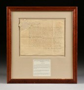 AN ANTIQUE AMBASSADORIAL
 DOCUMENT, SIGNED BY QUEEN VICT...AN ANTIQUE AMBASSADORIAL DOCUMENT, SIGNED BY QUEEN VICTORIA, COMMISION OF WALTER TSCHUDI LYALL CONSUL OF THE STATE OF TEXAS AND FOR THE TERRITORY OF NEW MEXICO, LONDON, JUNE 1, 1886, hand inscribed lithograph on paper, signed U/L "Victoria R.I.(Regina Imperatrix)," and with seal, appointing British Consul to serve in Galveston, Texas. 13" x 16 1/2" Provenance: Property from a Corporate Collection, Houston, Texas. Property from a Corporate Collection, Houston, Texas Condition: Some creasing, mild fading of ink, some ink transfer, toning, handling creases, a small buckle, overall in good to very good condition, wear commensurate with age. Simpson Galleries strongly encourages in-person inspection of items by the bidder. Statements by Simpson Galleries regarding the condition of objects are for guidance only and should not be relied upon as statements of fact and do not constitute a representation, warranty, or assumption of liability by Simpson Galleries. All lots offered are sold "AS IS.” NO REFUNDS will be issued based on condition.
AN ANTIQUE AMBASSADORIAL
AN ANTIQUE AMBASSADORIAL DOCUMENT, SIGNED BY QUEEN VICT...AN ANTIQUE AMBASSADORIAL DOCUMENT, SIGNED BY QUEEN VICTORIA, COMMISION OF WALTER TSCHUDI LYALL CONSUL OF THE STATE OF TEXAS AND FOR THE TERRITORY OF NEW MEXICO, LONDON, JUNE 1, 1886, hand inscribed lithograph on paper, signed U/L "Victoria R.I.(Regina Imperatrix)," and with seal, appointing British Consul to serve in Galveston, Texas. 13" x 16 1/2" Provenance: Property from a Corporate Collection, Houston, Texas. Property from a Corporate Collection, Houston, Texas Condition: Some creasing, mild fading of ink, some ink transfer, toning, handling creases, a small buckle, overall in good to very good condition, wear commensurate with age. Simpson Galleries strongly encourages in-person inspection of items by the bidder. Statements by Simpson Galleries regarding the condition of objects are for guidance only and should not be relied upon as statements of fact and do not constitute a representation, warranty, or assumption of liability by Simpson Galleries. All lots offered are sold "AS IS.” NO REFUNDS will be issued based on condition. -
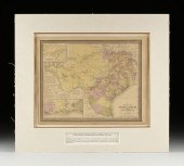 AN ANTIQUE ANTEBELLUM MAP, "MAP
 OF THE STATE OF TEXAS,"...AN ANTIQUE ANTEBELLUM MAP, "Map of the State of Texas," PHILADELPHIA, CIRCA 1852, hand colored lithograph on paper, a page fragment from an atlas, no. 25, by J.H. Young, published by Thomas Cowperthwait & Co., J.L. Hazzard, engraver, "Entered according to act of Congress in the year 1852 by Thomas, Cowperthwait & Co., in the Clerk's office of the District court of of the Eastern District of Pennsylvania," inset U/L, "Northern Texas," and L/L inset, "Map of the Vicinity of Galveston City," including a population chart organized by race and freed status. 13 5/8" x 17" Note: The map is a good example of Texas in early statehood, showing old indigenous roads, waterways, elevation by hachures, some lands identified by natural abundances and were yet undetermined territory. Short notes about water depths, "The Grand Indian Crossing is a shallow place in the Rio Grande 1,000 miles from its mouth with 4 feet water. Here the Apaches and Comanches cross in their annual predatory incursions into Mexico." Provenance: Property from a Corporate Collection, Houston, Texas. Property from a Corporate Collection, Houston, Texas Condition: Some foxing spots, toning of paper, some fading of hand color, tears and creases at edges, overall in good to very good condition, wear commensurate with age. Simpson Galleries strongly encourages in-person inspection of items by the bidder. Statements by Simpson Galleries regarding the condition of objects are for guidance only and should not be relied upon as statements of fact and do not constitute a representation, warranty, or assumption of liability by Simpson Galleries. All lots offered are sold "AS IS.” NO REFUNDS will be issued based on condition.
AN ANTIQUE ANTEBELLUM MAP, "MAP
AN ANTIQUE ANTEBELLUM MAP, "MAP OF THE STATE OF TEXAS,"...AN ANTIQUE ANTEBELLUM MAP, "Map of the State of Texas," PHILADELPHIA, CIRCA 1852, hand colored lithograph on paper, a page fragment from an atlas, no. 25, by J.H. Young, published by Thomas Cowperthwait & Co., J.L. Hazzard, engraver, "Entered according to act of Congress in the year 1852 by Thomas, Cowperthwait & Co., in the Clerk's office of the District court of of the Eastern District of Pennsylvania," inset U/L, "Northern Texas," and L/L inset, "Map of the Vicinity of Galveston City," including a population chart organized by race and freed status. 13 5/8" x 17" Note: The map is a good example of Texas in early statehood, showing old indigenous roads, waterways, elevation by hachures, some lands identified by natural abundances and were yet undetermined territory. Short notes about water depths, "The Grand Indian Crossing is a shallow place in the Rio Grande 1,000 miles from its mouth with 4 feet water. Here the Apaches and Comanches cross in their annual predatory incursions into Mexico." Provenance: Property from a Corporate Collection, Houston, Texas. Property from a Corporate Collection, Houston, Texas Condition: Some foxing spots, toning of paper, some fading of hand color, tears and creases at edges, overall in good to very good condition, wear commensurate with age. Simpson Galleries strongly encourages in-person inspection of items by the bidder. Statements by Simpson Galleries regarding the condition of objects are for guidance only and should not be relied upon as statements of fact and do not constitute a representation, warranty, or assumption of liability by Simpson Galleries. All lots offered are sold "AS IS.” NO REFUNDS will be issued based on condition. -
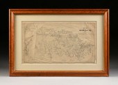 AN ANTIQUE CADASTRAL MAP, "MAP OF
 BANDERA COUNTY, TEXAS...AN ANTIQUE CADASTRAL MAP, "Map of Bandera County, Texas," ST. LOUIS, CIRCA 1880, lithograph on paper, showing boundaries of Bandera County delineated from portions of Bexar, Kendall, Uvalde, Kerr, Medina and Edwards counties, the Medina River, a major waterway cradles Bandera City, "Copyright 1879, W.C. Walsh, Commissioner of the Genl. Land Office of the State of Texas," "Lithographed by August Gast & Co.'s New Process," "I, W.C. Walsh, Commissioner of the General Land, do certify that the above Map of Bandera Co. is a true and correct copy of the map now in use in this office, compiled from official data," signed in plate. 16 1/2" x 29 1/2" Provenance: Property from a Corporate Collection, Houston, Texas. Property from a Corporate Collection, Houston, Texas Condition: Some losses, linen backed, creases, toning, stains, tears near margins, and expected wear, overall in good condition, wear commensurate with age. Simpson Galleries strongly encourages in-person inspection of items by the bidder. Statements by Simpson Galleries regarding the condition of objects are for guidance only and should not be relied upon as statements of fact and do not constitute a representation, warranty, or assumption of liability by Simpson Galleries. All lots offered are sold "AS IS.” NO REFUNDS will be issued based on condition.
AN ANTIQUE CADASTRAL MAP, "MAP OF
AN ANTIQUE CADASTRAL MAP, "MAP OF BANDERA COUNTY, TEXAS...AN ANTIQUE CADASTRAL MAP, "Map of Bandera County, Texas," ST. LOUIS, CIRCA 1880, lithograph on paper, showing boundaries of Bandera County delineated from portions of Bexar, Kendall, Uvalde, Kerr, Medina and Edwards counties, the Medina River, a major waterway cradles Bandera City, "Copyright 1879, W.C. Walsh, Commissioner of the Genl. Land Office of the State of Texas," "Lithographed by August Gast & Co.'s New Process," "I, W.C. Walsh, Commissioner of the General Land, do certify that the above Map of Bandera Co. is a true and correct copy of the map now in use in this office, compiled from official data," signed in plate. 16 1/2" x 29 1/2" Provenance: Property from a Corporate Collection, Houston, Texas. Property from a Corporate Collection, Houston, Texas Condition: Some losses, linen backed, creases, toning, stains, tears near margins, and expected wear, overall in good condition, wear commensurate with age. Simpson Galleries strongly encourages in-person inspection of items by the bidder. Statements by Simpson Galleries regarding the condition of objects are for guidance only and should not be relied upon as statements of fact and do not constitute a representation, warranty, or assumption of liability by Simpson Galleries. All lots offered are sold "AS IS.” NO REFUNDS will be issued based on condition. -
 ROBERT PUMMILL (AMERICAN/TEXAS B.
 1936) A PAINTING, "HI...ROBERT PUMMILL (American/Texas b. 1936) A PAINTING, "Hill Country Vista," JANUARY 1, 2011, oil on canvas, signed L/R, verso the artist's paper label. 16" x 24" Provenance: Estate of Texas Governor John B. Connally, Houston, Texas. Condition: In very good condition, wear commensurate with age. Simpson Galleries strongly encourages in-person inspection of items by the bidder. Statements by Simpson Galleries regarding the condition of objects are for guidance only and should not be relied upon as statements of fact and do not constitute a representation, warranty, or assumption of liability by Simpson Galleries. All lots offered are sold "AS IS." NO REFUNDS will be issued based on condition.
ROBERT PUMMILL (AMERICAN/TEXAS B.
ROBERT PUMMILL (AMERICAN/TEXAS B. 1936) A PAINTING, "HI...ROBERT PUMMILL (American/Texas b. 1936) A PAINTING, "Hill Country Vista," JANUARY 1, 2011, oil on canvas, signed L/R, verso the artist's paper label. 16" x 24" Provenance: Estate of Texas Governor John B. Connally, Houston, Texas. Condition: In very good condition, wear commensurate with age. Simpson Galleries strongly encourages in-person inspection of items by the bidder. Statements by Simpson Galleries regarding the condition of objects are for guidance only and should not be relied upon as statements of fact and do not constitute a representation, warranty, or assumption of liability by Simpson Galleries. All lots offered are sold "AS IS." NO REFUNDS will be issued based on condition. -
 PORFIRIO SALINAS (AMERICAN/TEXAS
 1910-1973) A PAINTING,...PORFIRIO SALINAS (American/Texas 1910-1973) A PAINTING, "Chickens Watering by the Coop," oil on canvas, signed L/L, "Porfirio Salinas," verso a paper gallery label. 25" x 30" Provenance: Country Store Gallery, Austin, Texas. Estate of Texas Governor John B. Connally, Houston, Texas. Condition: Stretcher marks, some craquelure, and cracks, mild wear expected, overall in good to very good condition, wear commensurate with age. Simpson Galleries strongly encourages in-person inspection of items by the bidder. Statements by Simpson Galleries regarding the condition of objects are for guidance only and should not be relied upon as statements of fact and do not constitute a representation, warranty, or assumption of liability by Simpson Galleries. All lots offered are sold "AS IS." NO REFUNDS will be issued based on condition.
PORFIRIO SALINAS (AMERICAN/TEXAS
PORFIRIO SALINAS (AMERICAN/TEXAS 1910-1973) A PAINTING,...PORFIRIO SALINAS (American/Texas 1910-1973) A PAINTING, "Chickens Watering by the Coop," oil on canvas, signed L/L, "Porfirio Salinas," verso a paper gallery label. 25" x 30" Provenance: Country Store Gallery, Austin, Texas. Estate of Texas Governor John B. Connally, Houston, Texas. Condition: Stretcher marks, some craquelure, and cracks, mild wear expected, overall in good to very good condition, wear commensurate with age. Simpson Galleries strongly encourages in-person inspection of items by the bidder. Statements by Simpson Galleries regarding the condition of objects are for guidance only and should not be relied upon as statements of fact and do not constitute a representation, warranty, or assumption of liability by Simpson Galleries. All lots offered are sold "AS IS." NO REFUNDS will be issued based on condition. -
 PORFIRIO SALINAS (AMERICAN/TEXAS
 1910-1973) A PAINTING,...PORFIRIO SALINAS (American/Texas 1910-1973) A PAINTING, "Blooming Cacti by the Road," oil on canvas, signed L/L. 15 1/2" x 19 1/2" Provenance: Estate of Texas Governor John B. Connally, Houston, Texas. Condition: In very good condition, wear commensurate with age. Simpson Galleries strongly encourages in-person inspection of items by the bidder. Statements by Simpson Galleries regarding the condition of objects are for guidance only and should not be relied upon as statements of fact and do not constitute a representation, warranty, or assumption of liability by Simpson Galleries. All lots offered are sold "AS IS." NO REFUNDS will be issued based on condition.
PORFIRIO SALINAS (AMERICAN/TEXAS
PORFIRIO SALINAS (AMERICAN/TEXAS 1910-1973) A PAINTING,...PORFIRIO SALINAS (American/Texas 1910-1973) A PAINTING, "Blooming Cacti by the Road," oil on canvas, signed L/L. 15 1/2" x 19 1/2" Provenance: Estate of Texas Governor John B. Connally, Houston, Texas. Condition: In very good condition, wear commensurate with age. Simpson Galleries strongly encourages in-person inspection of items by the bidder. Statements by Simpson Galleries regarding the condition of objects are for guidance only and should not be relied upon as statements of fact and do not constitute a representation, warranty, or assumption of liability by Simpson Galleries. All lots offered are sold "AS IS." NO REFUNDS will be issued based on condition. -
 A ROCOCO REVIVAL STYLE SILVERPLATED
 AND LIDDED PUNCH UR...A ROCOCO REVIVAL STYLE SILVERPLATED AND LIDDED PUNCH URN, 20TH CENTURY, of bombé vasiform with a circular twist gadrooned lid surmounted by a bacchanalian maiden's bust finial, above a detachable rim cast as a pierced band of stylized rocaille interspersed with "C" scrolled cartouches within similar side cartouches topped by open trellis panels and suspending blossoming branches, over the removable bombé vessel with sides centering engraved curling leafy details enclosing trellis reserves and floral stems, encased by a conforming reticulated shell of swirling acanthine foliage and flowering clusters centering seated cherub figures clutching blank armorial oval shields, flanked by pierced auricular handles supporting a seated figure of Bacchus wearing a grape leaf-and-cluster diadem and spotted leopard's skin pelt while holding his thyrsus and toasting aloft with his wine cup, opposite a matching handle with a seated figure of the muse Terpsichore wearing billowing robes and playing her lyre, raised on a stepped circular base modeled with twist gadrooned decoration enclosed by undulating foliage over rocaille ending on scrolling feet. Height: 24 1/2" Width: 16" Depth: 13" Provenance: Estate of Texas Governor John B. Connally, Houston, Texas. Condition: Nicely cast with appropriate details and in good condition with some normal light surface scratches from use and polish residue in crevices, otherwise good shape. The lid and rim are removable so as to be able to remove the bombe urn. Terpsichore's lyre is lacking the strings. Simpson Galleries strongly encourages in-person inspection of items by the bidder. Statements by Simpson Galleries regarding the condition of objects are for guidance only and should not be relied upon as statements of fact and do not constitute a representation, warranty, or assumption of liability by Simpson Galleries. All lots offered are sold "AS IS." NO REFUNDS will be issued based on condition.
A ROCOCO REVIVAL STYLE SILVERPLATED
A ROCOCO REVIVAL STYLE SILVERPLATED AND LIDDED PUNCH UR...A ROCOCO REVIVAL STYLE SILVERPLATED AND LIDDED PUNCH URN, 20TH CENTURY, of bombé vasiform with a circular twist gadrooned lid surmounted by a bacchanalian maiden's bust finial, above a detachable rim cast as a pierced band of stylized rocaille interspersed with "C" scrolled cartouches within similar side cartouches topped by open trellis panels and suspending blossoming branches, over the removable bombé vessel with sides centering engraved curling leafy details enclosing trellis reserves and floral stems, encased by a conforming reticulated shell of swirling acanthine foliage and flowering clusters centering seated cherub figures clutching blank armorial oval shields, flanked by pierced auricular handles supporting a seated figure of Bacchus wearing a grape leaf-and-cluster diadem and spotted leopard's skin pelt while holding his thyrsus and toasting aloft with his wine cup, opposite a matching handle with a seated figure of the muse Terpsichore wearing billowing robes and playing her lyre, raised on a stepped circular base modeled with twist gadrooned decoration enclosed by undulating foliage over rocaille ending on scrolling feet. Height: 24 1/2" Width: 16" Depth: 13" Provenance: Estate of Texas Governor John B. Connally, Houston, Texas. Condition: Nicely cast with appropriate details and in good condition with some normal light surface scratches from use and polish residue in crevices, otherwise good shape. The lid and rim are removable so as to be able to remove the bombe urn. Terpsichore's lyre is lacking the strings. Simpson Galleries strongly encourages in-person inspection of items by the bidder. Statements by Simpson Galleries regarding the condition of objects are for guidance only and should not be relied upon as statements of fact and do not constitute a representation, warranty, or assumption of liability by Simpson Galleries. All lots offered are sold "AS IS." NO REFUNDS will be issued based on condition. -
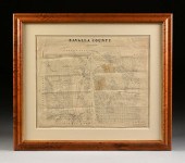 AN ANTIQUE CADASTRAL MAP, "ZAVALA
 COUNTY, " ST. LOUIS, ...AN ANTIQUE CADASTRAL MAP, "Zavala County, " ST. LOUIS, CIRCA 1880, lithograph on paper with hand color and pencil inscriptions regarding the location of, "La Pryor," as well as hand drawn routes north to Uvalde, west to Eagle Pass, and south to Crystal City, "Lithographed by August Gast & Co.'s New Process, St. Louis," upper right, "Copyright 1879, W.C. Walsh Commissioner of the General Land Office of the State of Texas," upper left, "I, W.C. Walsh, Commissioner of the General Land, do hereby certify that this Map of Zavala County is [a] true and correct of the original map now in use in this office from official data," signed in plate. 20 1/2" x 25 1/2" Provenance: Property from a Corporate Collection, Houston, Texas. Condition: Some smudging, losses, backed, creases, toning, stains, fading of hand color and pencil, overall in good condition, wear commensurate with age. Simpson Galleries strongly encourages in-person inspection of items by the bidder. Statements by Simpson Galleries regarding the condition of objects are for guidance only and should not be relied upon as statements of fact and do not constitute a representation, warranty, or assumption of liability by Simpson Galleries. All lots offered are sold "AS IS." NO REFUNDS will be issued based on condition.
AN ANTIQUE CADASTRAL MAP, "ZAVALA
AN ANTIQUE CADASTRAL MAP, "ZAVALA COUNTY, " ST. LOUIS, ...AN ANTIQUE CADASTRAL MAP, "Zavala County, " ST. LOUIS, CIRCA 1880, lithograph on paper with hand color and pencil inscriptions regarding the location of, "La Pryor," as well as hand drawn routes north to Uvalde, west to Eagle Pass, and south to Crystal City, "Lithographed by August Gast & Co.'s New Process, St. Louis," upper right, "Copyright 1879, W.C. Walsh Commissioner of the General Land Office of the State of Texas," upper left, "I, W.C. Walsh, Commissioner of the General Land, do hereby certify that this Map of Zavala County is [a] true and correct of the original map now in use in this office from official data," signed in plate. 20 1/2" x 25 1/2" Provenance: Property from a Corporate Collection, Houston, Texas. Condition: Some smudging, losses, backed, creases, toning, stains, fading of hand color and pencil, overall in good condition, wear commensurate with age. Simpson Galleries strongly encourages in-person inspection of items by the bidder. Statements by Simpson Galleries regarding the condition of objects are for guidance only and should not be relied upon as statements of fact and do not constitute a representation, warranty, or assumption of liability by Simpson Galleries. All lots offered are sold "AS IS." NO REFUNDS will be issued based on condition. -
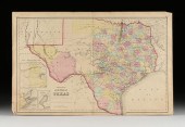 J.H. COLTON (1800-1893) A MAP, "NEW
 MAP OF THE STATE OF...J.H. COLTON (1800-1893) A MAP, "New Map of the State of Texas," NEW YORK, CIRCA 1855, hand-colored lithograph on paper, "Compiled from J. de Cordova's large Map," and, "Published by J.H. Colton & Co., No 172 William St., New York.," plates no. 37 and no. 38 joined, the map with three inset views lower left, "Plan of the northern part of Texas," "Plan of Galveston Bay from the U.S. Coast Survey," and, "Plan of Sabine Lake," sheet: 17" x 26 1/2". Condition: Some tears at ends, small surface stains, overall in good condition. Unframed. Simpson Galleries strongly encourages in-person inspection of items by the bidder. Statements by Simpson Galleries regarding the condition of objects are for guidance only and should not be relied upon as statements of fact and do not constitute a representation, warranty, or assumption of liability by Simpson Galleries. All lots offered are sold "AS IS."
J.H. COLTON (1800-1893) A MAP, "NEW
J.H. COLTON (1800-1893) A MAP, "NEW MAP OF THE STATE OF...J.H. COLTON (1800-1893) A MAP, "New Map of the State of Texas," NEW YORK, CIRCA 1855, hand-colored lithograph on paper, "Compiled from J. de Cordova's large Map," and, "Published by J.H. Colton & Co., No 172 William St., New York.," plates no. 37 and no. 38 joined, the map with three inset views lower left, "Plan of the northern part of Texas," "Plan of Galveston Bay from the U.S. Coast Survey," and, "Plan of Sabine Lake," sheet: 17" x 26 1/2". Condition: Some tears at ends, small surface stains, overall in good condition. Unframed. Simpson Galleries strongly encourages in-person inspection of items by the bidder. Statements by Simpson Galleries regarding the condition of objects are for guidance only and should not be relied upon as statements of fact and do not constitute a representation, warranty, or assumption of liability by Simpson Galleries. All lots offered are sold "AS IS." -
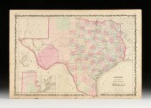 A.J. JOHNSON (1827-1884) AN
 AMERICAN CIVIL WAR MAP, "JO...A.J. JOHNSON (1827-1884) AN AMERICAN CIVIL WAR MAP, "Johnson's New Map of the State of Texas," NEW YORK, CIRCA 1863, hand-colored lithograph on wove paper, plates 43. and 44. joined, published by Johnson and Ward, from Family Atlas, with three inset sub-maps, "Plan of Galveston Bay," "Plan of the Northern part of Texas," and "Plan of Sabine Lake," with ornate heraldic leafy scroll border. 18" x 26 1/2" Condition: Unframed, some tears at edges, smudges, some tone, foxing, crumpled and creased areas. Unframed. Simpson Galleries strongly encourages in-person inspection of items by the bidder. Statements by Simpson Galleries regarding the condition of objects are for guidance only and should not be relied upon as statements of fact and do not constitute a representation, warranty, or assumption of liability by Simpson Galleries. All lots offered are sold "AS IS.”
A.J. JOHNSON (1827-1884) AN
A.J. JOHNSON (1827-1884) AN AMERICAN CIVIL WAR MAP, "JO...A.J. JOHNSON (1827-1884) AN AMERICAN CIVIL WAR MAP, "Johnson's New Map of the State of Texas," NEW YORK, CIRCA 1863, hand-colored lithograph on wove paper, plates 43. and 44. joined, published by Johnson and Ward, from Family Atlas, with three inset sub-maps, "Plan of Galveston Bay," "Plan of the Northern part of Texas," and "Plan of Sabine Lake," with ornate heraldic leafy scroll border. 18" x 26 1/2" Condition: Unframed, some tears at edges, smudges, some tone, foxing, crumpled and creased areas. Unframed. Simpson Galleries strongly encourages in-person inspection of items by the bidder. Statements by Simpson Galleries regarding the condition of objects are for guidance only and should not be relied upon as statements of fact and do not constitute a representation, warranty, or assumption of liability by Simpson Galleries. All lots offered are sold "AS IS.” -
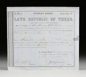 A PUBLIC DEBT OF THE LATE
 REPUBLIC OF TEXAS, FOR 1842 S...A PUBLIC DEBT OF THE LATE REPUBLIC OF TEXAS, FOR 1842 SOMERVILLE CAMPAIGN, SECOND CLASS "B," AUSTIN, JULY 31, 1855, lithograph and manuscript ink on blue tinted wove paper, No. 6434, "This is to Certify that Henry Steel, atty. of J.H. Hobbs has under the provisions of an Act of the Legislature of the State of Texas, entitled An Act to extend the provisions of 'An Act to provide for ascertaining the Debt of the late Republic of Texas,' approve February 7, 1853, filed with the Auditor and Comptroller, A claim for Services on the Somerville Campaign 1842, accounting to Forty-five Dollars...," verso endorsed, "Received Payment July 31, 1865, Henry Steel," and in margin repeating the document No. 6434 and 2nd Class. 10" x 11 1/4" Provenance: Condition: Unframed, cancellation marks, repair with gum stain, creases, ink bleed, one corner torn; otherwise no visible damage or sign of repair. Simpson Galleries strongly encourages in-person inspection of items by the bidder. Statements by Simpson Galleries regarding the condition of objects are for guidance only and should not be relied upon as statements of fact and do not constitute a representation, warranty, or assumption of liability by Simpson Galleries. All lots offered are sold "AS IS.”
A PUBLIC DEBT OF THE LATE
A PUBLIC DEBT OF THE LATE REPUBLIC OF TEXAS, FOR 1842 S...A PUBLIC DEBT OF THE LATE REPUBLIC OF TEXAS, FOR 1842 SOMERVILLE CAMPAIGN, SECOND CLASS "B," AUSTIN, JULY 31, 1855, lithograph and manuscript ink on blue tinted wove paper, No. 6434, "This is to Certify that Henry Steel, atty. of J.H. Hobbs has under the provisions of an Act of the Legislature of the State of Texas, entitled An Act to extend the provisions of 'An Act to provide for ascertaining the Debt of the late Republic of Texas,' approve February 7, 1853, filed with the Auditor and Comptroller, A claim for Services on the Somerville Campaign 1842, accounting to Forty-five Dollars...," verso endorsed, "Received Payment July 31, 1865, Henry Steel," and in margin repeating the document No. 6434 and 2nd Class. 10" x 11 1/4" Provenance: Condition: Unframed, cancellation marks, repair with gum stain, creases, ink bleed, one corner torn; otherwise no visible damage or sign of repair. Simpson Galleries strongly encourages in-person inspection of items by the bidder. Statements by Simpson Galleries regarding the condition of objects are for guidance only and should not be relied upon as statements of fact and do not constitute a representation, warranty, or assumption of liability by Simpson Galleries. All lots offered are sold "AS IS.”
...many more examples with full details are available to our members - Learn more
Easy & Visual methods to Identify & Appraise Antiques & Collectibles
EASY. FAST. ACCURATE.
Research at its best
We are here to help!
Our research tools include:

Thousands of makers marks for PORCELAIN, POTTERY CHINAWARE, FIGURINES, VASES
see details...

Thousands of marks & hallmarks for SILVER & JEWELRY, PEWTER, PRECIOUS METALS, SILVERPLATE
see details...
