Pricing Guides & Dictionary of Makers Marks for Antiques & Collectibles
A few examples of appraisal values for
TENNESSEE
Search our price guide for your own treasures
-
 Tenn
Tenn
Tenn
Tenn -
 Kentucky/Tenn
Kentucky/Tenn
Kentucky/Tenn -
 Tenn
Tenn
Tenn
Tenn -
 Virginia/Tenn
Virginia/Tenn
Virginia/Tenn -
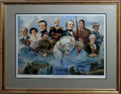 TENNESSEE PRINT"The Pride of
 Tennessee" pencil signed and numbered by "Michael Sloan, 2232/3000" depicts the state capital and most all of important Tennesseans, 20th century print and frame, 33"x27"
TENNESSEE PRINT"The Pride of
TENNESSEE PRINT"The Pride of Tennessee" pencil signed and numbered by "Michael Sloan, 2232/3000" depicts the state capital and most all of important Tennesseans, 20th century print and frame, 33"x27" -
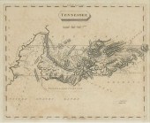
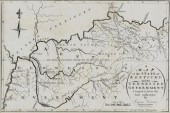
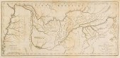 1799 TENNESSEE MAPA MAP OF THE
 TENNASSEE GOVERNMENT FROM THE LATEST SURVEYS, 1799, Engraved for Payne's Geography. This early map of Tennessee depicts Knoxville, Nashville, and "Clerksville" (Clarksville); Memphis, which had not been founded yet, is in an area noted as "Light soil, long grass, little timber". Native American sites and villages such as Creeks Crossing Place and Cherokee are listed, along with Grandfather's Mountain, Great Iron Mountain, various rivers, and other geographical landmarks. 16-1/4" x 8-1/4", unframed. New mat included, 19-3/4" x 11-3/4". This map appeared in Volume IV of John Payne's New and Complete Universal Geography, published in New York in 1799, three years after Tennessee was founded. Condition: Margins trimmed with losses to right side not affecting image (left margin intact), folds with one 1/2" tear at one fold, not affecting image, light toning and some scattered tiny stains to margin.
1799 TENNESSEE MAPA MAP OF THE
1799 TENNESSEE MAPA MAP OF THE TENNASSEE GOVERNMENT FROM THE LATEST SURVEYS, 1799, Engraved for Payne's Geography. This early map of Tennessee depicts Knoxville, Nashville, and "Clerksville" (Clarksville); Memphis, which had not been founded yet, is in an area noted as "Light soil, long grass, little timber". Native American sites and villages such as Creeks Crossing Place and Cherokee are listed, along with Grandfather's Mountain, Great Iron Mountain, various rivers, and other geographical landmarks. 16-1/4" x 8-1/4", unframed. New mat included, 19-3/4" x 11-3/4". This map appeared in Volume IV of John Payne's New and Complete Universal Geography, published in New York in 1799, three years after Tennessee was founded. Condition: Margins trimmed with losses to right side not affecting image (left margin intact), folds with one 1/2" tear at one fold, not affecting image, light toning and some scattered tiny stains to margin. -
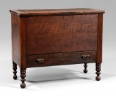
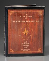
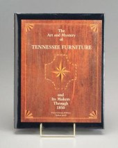 Tennessee furniture book, Dorita
 Coleman Williams and Nathan Harsh, The Art and Mystery of Tennessee Furniture, Tennessee Historical Society, Nashville, 1988, 11-1/4 x 9 in. Unopened in original plastic cover.
Tennessee furniture book, Dorita
Tennessee furniture book, Dorita Coleman Williams and Nathan Harsh, The Art and Mystery of Tennessee Furniture, Tennessee Historical Society, Nashville, 1988, 11-1/4 x 9 in. Unopened in original plastic cover. -
 TWO HISTORIES OF TENNESSEE As
 follows: History of Tennessee (Nashville: The Godspeed Publishing Co., 1887), no author cited, 4to (10 in.), three-quarter leather with gilt, 971 pp. with fold-out "Aboriginal" map showing the state's development during the early part of the 19th century (spine and top board disbound; map present, but in two sections; fair condition); plus, Hamer, Philip M. Tennessee, A History, 1673-1932 (New York: The American Historical Society, Inc., 1933), 4 vols., large 4to (10-3/4 in.), blue cloth with gilt spine (binding solid; sunning and damp stains to boards; good, reading condition).
TWO HISTORIES OF TENNESSEE As
TWO HISTORIES OF TENNESSEE As follows: History of Tennessee (Nashville: The Godspeed Publishing Co., 1887), no author cited, 4to (10 in.), three-quarter leather with gilt, 971 pp. with fold-out "Aboriginal" map showing the state's development during the early part of the 19th century (spine and top board disbound; map present, but in two sections; fair condition); plus, Hamer, Philip M. Tennessee, A History, 1673-1932 (New York: The American Historical Society, Inc., 1933), 4 vols., large 4to (10-3/4 in.), blue cloth with gilt spine (binding solid; sunning and damp stains to boards; good, reading condition). -
 TENNESSEE PORTRAIT OF A LADY19th
 century Tennessee oil on canvas portrait of a female, attributed to Middle TN, depicting an attractive female with dark hair attired in a satin dress with gold bow, detailed lace collar and lace hat. Unframed. 30 1/2" H x 25" W. 2nd Quarter 19th century. Note: Portrait found in a Middle Tennessee estate. Condition: Unframed. Significant losses/flaking around an oval perimeter, folding of canvas and paint loss around the square stretchers and perimeter of painting, especially lower left shoulder area.
TENNESSEE PORTRAIT OF A LADY19th
TENNESSEE PORTRAIT OF A LADY19th century Tennessee oil on canvas portrait of a female, attributed to Middle TN, depicting an attractive female with dark hair attired in a satin dress with gold bow, detailed lace collar and lace hat. Unframed. 30 1/2" H x 25" W. 2nd Quarter 19th century. Note: Portrait found in a Middle Tennessee estate. Condition: Unframed. Significant losses/flaking around an oval perimeter, folding of canvas and paint loss around the square stretchers and perimeter of painting, especially lower left shoulder area. -
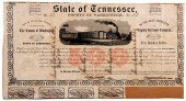 TENNESSEE RAILROAD BONDSSTATE OF
 TENNESSEE, COUNTY OF WASHINGTON, $500, "TO THE EAST TENNESSEE AND VIRGINIA RAILROAD COMPANY" BEARER BOND, DATED JANUARY 1853, JONESBOROUGH, TN, FOUR COUPONS ARE STILL ATTACHED TO THE BOND, 19" X 10"
TENNESSEE RAILROAD BONDSSTATE OF
TENNESSEE RAILROAD BONDSSTATE OF TENNESSEE, COUNTY OF WASHINGTON, $500, "TO THE EAST TENNESSEE AND VIRGINIA RAILROAD COMPANY" BEARER BOND, DATED JANUARY 1853, JONESBOROUGH, TN, FOUR COUPONS ARE STILL ATTACHED TO THE BOND, 19" X 10" -
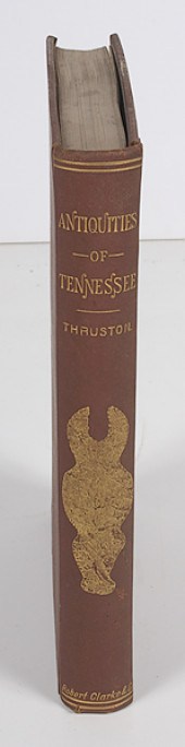 Antiquities of Tennessee and the
 Adjacent States by Thruston Thruston Gates P.? The Antiquities of the Tennessee and the Adjacent States and the State of Aborignal Society in the Scale of Civilization Represented by Them.? Cincinnati; Robert Clarke & Co. 1890.? 8vo gilt imprinted red buckram boards 369pp. Condition: Shelfwear else very good.
Antiquities of Tennessee and the
Antiquities of Tennessee and the Adjacent States by Thruston Thruston Gates P.? The Antiquities of the Tennessee and the Adjacent States and the State of Aborignal Society in the Scale of Civilization Represented by Them.? Cincinnati; Robert Clarke & Co. 1890.? 8vo gilt imprinted red buckram boards 369pp. Condition: Shelfwear else very good. -
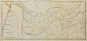 A MAP OF THE TENNASSEE [SIC]
 GOVERNMENT FROM THE LATEST..."A Map of the Tennassee [sic] Government from the latest Surveys 1810" by John Payne for his New and Complete Universal Geography, Volume 4, America, published by E. Low, New York. Uncolored map of early Tennessee featuring early towns and roads, including Knoxville, Nashville, and "Clerksville" (Clarksville), Native American towns and roads, boundary lines, rivers, mountain ranges, and remarks about the land including the inscription "Light Soil Long Grass. Little Timber. Broken Ground. on the Heads of these Rivers." vertical across the area of Western Tennessee. Title cartouche, lower right, references legend, lower left, scale of miles, lower left. "Engd. for the New Encyclopaedia Published by E. Low N. York" centered above map, "Long. W. from Philada." top right. Map surrounded by scale notations and black line border. Plate - 7 1/2" H x 16" W. Sheet - 9 3/4" H x 16 7/8" L. (Higher-resolution photos are available at www.caseantiques.com) Condition: Overall toning spots. Paper damaged around left and top right edges.
A MAP OF THE TENNASSEE [SIC]
A MAP OF THE TENNASSEE [SIC] GOVERNMENT FROM THE LATEST..."A Map of the Tennassee [sic] Government from the latest Surveys 1810" by John Payne for his New and Complete Universal Geography, Volume 4, America, published by E. Low, New York. Uncolored map of early Tennessee featuring early towns and roads, including Knoxville, Nashville, and "Clerksville" (Clarksville), Native American towns and roads, boundary lines, rivers, mountain ranges, and remarks about the land including the inscription "Light Soil Long Grass. Little Timber. Broken Ground. on the Heads of these Rivers." vertical across the area of Western Tennessee. Title cartouche, lower right, references legend, lower left, scale of miles, lower left. "Engd. for the New Encyclopaedia Published by E. Low N. York" centered above map, "Long. W. from Philada." top right. Map surrounded by scale notations and black line border. Plate - 7 1/2" H x 16" W. Sheet - 9 3/4" H x 16 7/8" L. (Higher-resolution photos are available at www.caseantiques.com) Condition: Overall toning spots. Paper damaged around left and top right edges. -
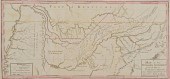 TENNESSEE MAP CIRCA 1795"Map of the
 Tennassee government, formerly part of North Carolina, taken chiefly from surveys by Gen. D. Smith and others." Engraving by Joseph T. Scott for Careys American Edition of Guthrie's Geography Improved. Hand colored borders. Ink script '39' en verso in upper right corner, first state. Sheet 10"H x 21 3/4", 9 1/8" x 19 3/4". Circa 1795. Note: This is the first map of Tennessee after statehood and the first map of Tennessee to be based on actual surveys, mostly the work of General Daniel Smith, a member of the 1779-80 Virginia-North Carolina border commission. The map shows some of the white settlements in the territory as well as towns and lands of the American Indians. Nashville and Clarksville are shown above the "S. Bound. of the military Reservation" in Middle Tennessee. Condition: Top sheet margin with lettering "Engraved for Careys American Edition of Guthrie's Geography improved." trimmed and only the lower edge of letters visible. Tear to lower right margin edge of sheet and does not appear to extend into map border. A couple of light toning spots.
TENNESSEE MAP CIRCA 1795"Map of the
TENNESSEE MAP CIRCA 1795"Map of the Tennassee government, formerly part of North Carolina, taken chiefly from surveys by Gen. D. Smith and others." Engraving by Joseph T. Scott for Careys American Edition of Guthrie's Geography Improved. Hand colored borders. Ink script '39' en verso in upper right corner, first state. Sheet 10"H x 21 3/4", 9 1/8" x 19 3/4". Circa 1795. Note: This is the first map of Tennessee after statehood and the first map of Tennessee to be based on actual surveys, mostly the work of General Daniel Smith, a member of the 1779-80 Virginia-North Carolina border commission. The map shows some of the white settlements in the territory as well as towns and lands of the American Indians. Nashville and Clarksville are shown above the "S. Bound. of the military Reservation" in Middle Tennessee. Condition: Top sheet margin with lettering "Engraved for Careys American Edition of Guthrie's Geography improved." trimmed and only the lower edge of letters visible. Tear to lower right margin edge of sheet and does not appear to extend into map border. A couple of light toning spots. -
 Williams, Harsh Tennessee
 Furniture, The Art and Mystery of Tennessee Furniture , Tennessee Historical Society, 1988, 11-1/4 x 9 in. Dust jacket with small corner tears, front paper with small whited-out area (owner inscription).
Williams, Harsh Tennessee
Williams, Harsh Tennessee Furniture, The Art and Mystery of Tennessee Furniture , Tennessee Historical Society, 1988, 11-1/4 x 9 in. Dust jacket with small corner tears, front paper with small whited-out area (owner inscription). -
 Harsh, Williams, Tenn
Harsh, Williams, Tenn
Harsh, Williams, Tenn -
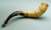 Tennessee presentation horn, "To CE
 Griffin, Alderman 1895-1910, Mayor 1910-1915, of Jackson, Tennessee, Member of B.P.O.E. F&AM, K of P, WOW, LO of M, AOUW, JOUAM, FOE, MW of A, IO of RM, WMA, Elder in CP Church", hunting scenes, trees with owls, animals, flag "Freedom For All Men", 19-1/2 in. Pest damage, normal discoloration and separation, some chips at large end.
Tennessee presentation horn, "To CE
Tennessee presentation horn, "To CE Griffin, Alderman 1895-1910, Mayor 1910-1915, of Jackson, Tennessee, Member of B.P.O.E. F&AM, K of P, WOW, LO of M, AOUW, JOUAM, FOE, MW of A, IO of RM, WMA, Elder in CP Church", hunting scenes, trees with owls, animals, flag "Freedom For All Men", 19-1/2 in. Pest damage, normal discoloration and separation, some chips at large end. -
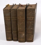 TENNESSEE HISTORY BY HAMMERA four
 volume set with a 1933 copy right, of Tennessee History from 1673-1932, nice condition with good bindings
TENNESSEE HISTORY BY HAMMERA four
TENNESSEE HISTORY BY HAMMERA four volume set with a 1933 copy right, of Tennessee History from 1673-1932, nice condition with good bindings -
 Antique map of Tennessee,
 beautifully matted and framed. Image 20.5 x 9.5 Overall framed 32.25 x 21.5 Condition: center crease, foxing CT Transfer Fee $20
Antique map of Tennessee,
Antique map of Tennessee, beautifully matted and framed. Image 20.5 x 9.5 Overall framed 32.25 x 21.5 Condition: center crease, foxing CT Transfer Fee $20 -
 TENN. MAP 1811, PAYNE/LOW"A Map
 of the Tennassee [sic] Government from the latest Surveys 1810", by John Payne, published by E. Low, New York, 1811. From "A New and Complete Universal Geography", Vol. IV, by John Payne. Copper plate engraving of early Tennessee depicting early towns and roads, including Knoxville, Nashville, and "Clerksville" (Clarksville), Native American towns and roads, boundary lines, rivers, mountain ranges, and remarks about the land including the inscription "Light Soil Long Grass. Little Timber. Broken Ground. on the Heads of these Rivers." vertical across the area of Western Tennessee. Title, lower right, references and scale of miles, lower left. "Long. W. from Philada." top right above map. Map surrounded by scale notations and line border. Image - 6 7/8" H x 15" W. Sheet - 10" H x 16" W. Early 19th century. Provenance: Collection of Charles and Ann Wells, Nashville, Tennessee. (Higher-resolution photos are available at www.caseantiques.com) Condition: Areas of toning, largest 4" top left, on surface of sheet. Toning impression of text page visible on left side of sheet. Black scuffs, top left corner of plate impression. Tears, largest 1/4", lower right edge of sheet. Areas of toning, toning impression of text page, visible en verso.
TENN. MAP 1811, PAYNE/LOW"A Map
TENN. MAP 1811, PAYNE/LOW"A Map of the Tennassee [sic] Government from the latest Surveys 1810", by John Payne, published by E. Low, New York, 1811. From "A New and Complete Universal Geography", Vol. IV, by John Payne. Copper plate engraving of early Tennessee depicting early towns and roads, including Knoxville, Nashville, and "Clerksville" (Clarksville), Native American towns and roads, boundary lines, rivers, mountain ranges, and remarks about the land including the inscription "Light Soil Long Grass. Little Timber. Broken Ground. on the Heads of these Rivers." vertical across the area of Western Tennessee. Title, lower right, references and scale of miles, lower left. "Long. W. from Philada." top right above map. Map surrounded by scale notations and line border. Image - 6 7/8" H x 15" W. Sheet - 10" H x 16" W. Early 19th century. Provenance: Collection of Charles and Ann Wells, Nashville, Tennessee. (Higher-resolution photos are available at www.caseantiques.com) Condition: Areas of toning, largest 4" top left, on surface of sheet. Toning impression of text page visible on left side of sheet. Black scuffs, top left corner of plate impression. Tears, largest 1/4", lower right edge of sheet. Areas of toning, toning impression of text page, visible en verso. -
 TENNESSEE POTTERIES, POTS AND
 POTTERS, VOLS. I & IITwo (2) volumes of "Tennessee Potteries, Pots, and Potters - 1790s to 1950", by Samuel D. Smith and Stephen Rogers. Published in 2011 by Tennessee Department of Environment and Conservation Division of Archaeology. This two volume set with over 1,000 pages was the result of 35 years of work on the subject by Smith and Rogers. Limited number published. Set includes CD. Condition: Mint condition.
TENNESSEE POTTERIES, POTS AND
TENNESSEE POTTERIES, POTS AND POTTERS, VOLS. I & IITwo (2) volumes of "Tennessee Potteries, Pots, and Potters - 1790s to 1950", by Samuel D. Smith and Stephen Rogers. Published in 2011 by Tennessee Department of Environment and Conservation Division of Archaeology. This two volume set with over 1,000 pages was the result of 35 years of work on the subject by Smith and Rogers. Limited number published. Set includes CD. Condition: Mint condition. -
 NASHVILLE BATTLEFIELDS AND TN
 MAPTwo Tennessee related maps. 1st item: A NEW MAP OF TENNESSEE WITH ITS ROADS AND DISTANCES FROM PLACE TO PLACE ALONG THE STAGE AND STEAM BOAT ROUTES by H.P. Tanner, dated 1841, showing counties, canals, railroads and leading roads, along with a table of steamboat routes. Environs of Nashville and Knoxville in upper corners. Image 10 3/4" by 14 3/4". In plain wood frame, overall: 13 1/2' x 17 1/2". 2nd item: BATTLEFIELDS IN FRONT OF NASHVILLE WHERE THE UNITED STATES FORCES COMMANDED BY MAJOR GENERAL GEO. H. THOMAS DEFEATED AND ROUTED THE REBEL ARMY UNDER GENERAL HOOD DECEMBER 15TH AND 16TH 1864; 39th Cong. 1st Session Report of the Chief Engineer USA, Surveyed and drawn under the direction of Gen. Tower by M. Peseux. Legend with text detailing battle upper left. Lithographed map, late 19th century. Sight - 13" x 15 3/4", Overall - 13 3/4" x 17 3/8" in plain wood frame. Margins likely trimmed. Provenance: Collection of James and Marlin Phythyon (Sanders), Nashville, Tennessee. (Higher-resolution photos are available at www.caseantiques.com) Condition: Not examined out of frame. Tanner map has overall toning, 2 spot of foxing at border area, 1/2" margin tear at left margin. Left and right margins possibly trimmed. Civil War map has light stain upper center and small spot of light foxing upper left, legend area, margins likely trimmed.
NASHVILLE BATTLEFIELDS AND TN
NASHVILLE BATTLEFIELDS AND TN MAPTwo Tennessee related maps. 1st item: A NEW MAP OF TENNESSEE WITH ITS ROADS AND DISTANCES FROM PLACE TO PLACE ALONG THE STAGE AND STEAM BOAT ROUTES by H.P. Tanner, dated 1841, showing counties, canals, railroads and leading roads, along with a table of steamboat routes. Environs of Nashville and Knoxville in upper corners. Image 10 3/4" by 14 3/4". In plain wood frame, overall: 13 1/2' x 17 1/2". 2nd item: BATTLEFIELDS IN FRONT OF NASHVILLE WHERE THE UNITED STATES FORCES COMMANDED BY MAJOR GENERAL GEO. H. THOMAS DEFEATED AND ROUTED THE REBEL ARMY UNDER GENERAL HOOD DECEMBER 15TH AND 16TH 1864; 39th Cong. 1st Session Report of the Chief Engineer USA, Surveyed and drawn under the direction of Gen. Tower by M. Peseux. Legend with text detailing battle upper left. Lithographed map, late 19th century. Sight - 13" x 15 3/4", Overall - 13 3/4" x 17 3/8" in plain wood frame. Margins likely trimmed. Provenance: Collection of James and Marlin Phythyon (Sanders), Nashville, Tennessee. (Higher-resolution photos are available at www.caseantiques.com) Condition: Not examined out of frame. Tanner map has overall toning, 2 spot of foxing at border area, 1/2" margin tear at left margin. Left and right margins possibly trimmed. Civil War map has light stain upper center and small spot of light foxing upper left, legend area, margins likely trimmed. -
 Tennessee Williams painting
 (Tennessee [Thomas Lanier] Williams, American, 1911-1983), "She Sang Beyond the Genius of the Sea", 1975, signed lower right "T.W.", mixed media on canvas, inscribed verso "Oil - Tennessee Williams 1975", unframed, 30 x 23-7/8 in. Original stretcher and tacking edge, lacking applied letters H, B, T, E, light grime. Private Collection.
Tennessee Williams painting
Tennessee Williams painting (Tennessee [Thomas Lanier] Williams, American, 1911-1983), "She Sang Beyond the Genius of the Sea", 1975, signed lower right "T.W.", mixed media on canvas, inscribed verso "Oil - Tennessee Williams 1975", unframed, 30 x 23-7/8 in. Original stretcher and tacking edge, lacking applied letters H, B, T, E, light grime. Private Collection. -
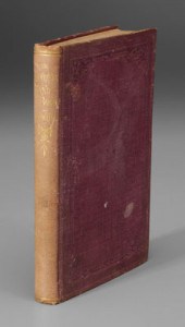
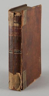 JOHN OVERTON TENNESSEE REPORTS
 NASHVILLE VOL 2 1817Overton, John. Tennessee reports, or Cases Ruled and Adjudged in the Superior Courts of Law & Equity, Federal Courts & Supreme Courts of Errors & Appeals for the State of Tennessee. Vol II. Copy Right Secured. Printed for the Proprietor by T. G. Bradford (Nashville). 1817. Viii, 436pp., [22pp. Index]. 8 1/2" H x 5 1/2" W x 1 5/8" D. Provenance: The living estate of Dr. and Mrs. Benjamin H. Caldwell, Nashville, TN. (Higher-resolution photos are available at www.caseantiques.com) Condition: Leather binding with cracked spine and a previous owner_s label partially attached. Spine has been glued to Text block and formally detached boards have been reattached with binders tape. Text is square and complete with some toning, foxing and varying degrees of offsetting. A very few margin check marks. A different previous owner has signed page 25.
JOHN OVERTON TENNESSEE REPORTS
JOHN OVERTON TENNESSEE REPORTS NASHVILLE VOL 2 1817Overton, John. Tennessee reports, or Cases Ruled and Adjudged in the Superior Courts of Law & Equity, Federal Courts & Supreme Courts of Errors & Appeals for the State of Tennessee. Vol II. Copy Right Secured. Printed for the Proprietor by T. G. Bradford (Nashville). 1817. Viii, 436pp., [22pp. Index]. 8 1/2" H x 5 1/2" W x 1 5/8" D. Provenance: The living estate of Dr. and Mrs. Benjamin H. Caldwell, Nashville, TN. (Higher-resolution photos are available at www.caseantiques.com) Condition: Leather binding with cracked spine and a previous owner_s label partially attached. Spine has been glued to Text block and formally detached boards have been reattached with binders tape. Text is square and complete with some toning, foxing and varying degrees of offsetting. A very few margin check marks. A different previous owner has signed page 25. -
 TENNESSEE POTTERIES, POTS AND
 POTTERS, VOLS. I & IITwo (2) volumes of the book "Tennessee Potteries, Pots, and Potters - 1790s to 1950", by Samuel D. Smith and Stephen Rogers. Published in 2011 by Tennessee Department of Environment and Conservation Division of Archaeology. This two volume set with over 1,000 pages was the result of 35 years of work on the subject by Smith and Rogers. Limited number published. (Higher-resolution photos are available at www.caseantiques.com) Condition: Overall excellent condition.
TENNESSEE POTTERIES, POTS AND
TENNESSEE POTTERIES, POTS AND POTTERS, VOLS. I & IITwo (2) volumes of the book "Tennessee Potteries, Pots, and Potters - 1790s to 1950", by Samuel D. Smith and Stephen Rogers. Published in 2011 by Tennessee Department of Environment and Conservation Division of Archaeology. This two volume set with over 1,000 pages was the result of 35 years of work on the subject by Smith and Rogers. Limited number published. (Higher-resolution photos are available at www.caseantiques.com) Condition: Overall excellent condition. -
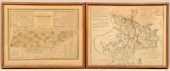
 TENNESSEE MAP, SAMUEL LEWIS &
 ALEXANDER LAWSON, 1804"Tennessee" Map, drawn by Samuel Lewis, engraved by Alexander Lawson, published by John Conrad & Co., Philadelphia, 1804. From "A New And Elegant General Atlas: Comprising All the New Discoveries, to the Present Time: Containing Sixty-Five Maps" by Aaron Arrowsmith and Samuel Lewis. Uncolored map of early Tennessee featuring early towns and roads, including Knoxville and Clarksville, county lines and Native American lines, names of counties, rivers, mountains, and remarks about the land including the inscription "Low Broken Ground" vertical across the area of Western Tennessee. Title cartouche, top center, scale of miles, top center, legend, lower right. "Longitude W. from Philada." centered above map, "Long. W. from London" centered below map. Map surrounded by scale notations and double line border. Housed in wooden frame with grey matte. Sight - 8 3/8" H x 10 3/8" W. Framed - 13 1/4" H x 15 1/4" L. (Higher-resolution photos are available at www.caseantiques.com) Condition: Overall foxing spots and water damage, top and lower left. Tape to upper margin edges when examined out of the frame.
TENNESSEE MAP, SAMUEL LEWIS &
TENNESSEE MAP, SAMUEL LEWIS & ALEXANDER LAWSON, 1804"Tennessee" Map, drawn by Samuel Lewis, engraved by Alexander Lawson, published by John Conrad & Co., Philadelphia, 1804. From "A New And Elegant General Atlas: Comprising All the New Discoveries, to the Present Time: Containing Sixty-Five Maps" by Aaron Arrowsmith and Samuel Lewis. Uncolored map of early Tennessee featuring early towns and roads, including Knoxville and Clarksville, county lines and Native American lines, names of counties, rivers, mountains, and remarks about the land including the inscription "Low Broken Ground" vertical across the area of Western Tennessee. Title cartouche, top center, scale of miles, top center, legend, lower right. "Longitude W. from Philada." centered above map, "Long. W. from London" centered below map. Map surrounded by scale notations and double line border. Housed in wooden frame with grey matte. Sight - 8 3/8" H x 10 3/8" W. Framed - 13 1/4" H x 15 1/4" L. (Higher-resolution photos are available at www.caseantiques.com) Condition: Overall foxing spots and water damage, top and lower left. Tape to upper margin edges when examined out of the frame. -
 1800 Kentucky and Tennessee map,
 "The State of Kentucky with the adjoining Territories…1800", including portions of North Western and South Western ("Tennessee Government") Territories, shows land "Reserved For The North Carolina Troops", engraved for New Encyclopaedia, I. Low, New York, hand colored, 8 x 10 in. Fine condition, minor edge toning. Collection of the Late John Bivins
1800 Kentucky and Tennessee map,
1800 Kentucky and Tennessee map, "The State of Kentucky with the adjoining Territories…1800", including portions of North Western and South Western ("Tennessee Government") Territories, shows land "Reserved For The North Carolina Troops", engraved for New Encyclopaedia, I. Low, New York, hand colored, 8 x 10 in. Fine condition, minor edge toning. Collection of the Late John Bivins -
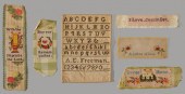
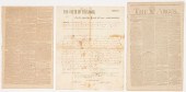 2 EARLY TENNESSEE RELATED NEWSPAPER
 ARTICLES PLUS 1 MAU...1st item: December 29, 1790 issue of the Gazette of the United States, Philadelphia, including article written by John Sevier (1745-1815), announcing the separation of what would become Tennessee from North Carolina and introducing the territorial Governor, William Blount. 15 3/4" H x 10" W. 2nd item: Mid 19th century copy of a John Sevier land grant dated December 31, 1808. The document grants five thousand acres to John Brown and his heirs. The land is located in the second district on the north side of Duck River and Knob Creek. Maury County was officially created Nov. 16, 1807 out of parts of Williamson and Davidson Counties. 16" H x 12 7/8" W. 3rd item: 1792 reprint of an original article featured in The Argus, discussing the newly formed town of Knoxville. It reads in part, "The ground where the treaty was so happily concluded, on the second day of July last, between the United States and the Cherokees, is now laid out into a town, and honoured with this name after major-general KNOX, secretary of war, and is the seat of government in the territory south of the Ohio". 17" H x 10 3/4" W. Condition: 1st item: Overall toning, fold lines, spotting, with some losses and separations at fold lines. 2nd & 3rd items: Both with overall toning and scattered spotting, the third page with minor chipping to perimeter.
2 EARLY TENNESSEE RELATED NEWSPAPER
2 EARLY TENNESSEE RELATED NEWSPAPER ARTICLES PLUS 1 MAU...1st item: December 29, 1790 issue of the Gazette of the United States, Philadelphia, including article written by John Sevier (1745-1815), announcing the separation of what would become Tennessee from North Carolina and introducing the territorial Governor, William Blount. 15 3/4" H x 10" W. 2nd item: Mid 19th century copy of a John Sevier land grant dated December 31, 1808. The document grants five thousand acres to John Brown and his heirs. The land is located in the second district on the north side of Duck River and Knob Creek. Maury County was officially created Nov. 16, 1807 out of parts of Williamson and Davidson Counties. 16" H x 12 7/8" W. 3rd item: 1792 reprint of an original article featured in The Argus, discussing the newly formed town of Knoxville. It reads in part, "The ground where the treaty was so happily concluded, on the second day of July last, between the United States and the Cherokees, is now laid out into a town, and honoured with this name after major-general KNOX, secretary of war, and is the seat of government in the territory south of the Ohio". 17" H x 10 3/4" W. Condition: 1st item: Overall toning, fold lines, spotting, with some losses and separations at fold lines. 2nd & 3rd items: Both with overall toning and scattered spotting, the third page with minor chipping to perimeter. -
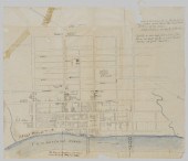 Civil War Manuscript Map of
 Nashville, Tenn
Civil War Manuscript Map of
Civil War Manuscript Map of Nashville, Tenn -
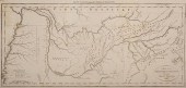
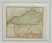
 KENTUCKY AND TENNESSEE MAP, 1796
 HARRISCyrus Harris, "A Map of the State of Kentucky and the Tennessee Government Compiled from the Best Authorities," from Jedidiah Morse's The American Universal Geography. Boston: Thomas and Andrews, 1796. Engraving by Amos Doolittle. 7 5/8" x 11 1/2" sight; 14 1/2" x 18 1/2" matted and framed in giltwood frame. Indian boundaries and the Southern boundary of the military reservation set aside for veterans of the North Carolina troops are shown. Roads shown include the "New and Short Road to Virginia." Many forts are indicated including Fort Washington, Fort Massac and Fort Jefferson. (Higher-resolution photos are available at www.caseantiques.com) Condition: Light toning and foxing, fold lines (as issued), note on back from previous seller indicates full margins. Hinge mounted. Conservation framing.
KENTUCKY AND TENNESSEE MAP, 1796
KENTUCKY AND TENNESSEE MAP, 1796 HARRISCyrus Harris, "A Map of the State of Kentucky and the Tennessee Government Compiled from the Best Authorities," from Jedidiah Morse's The American Universal Geography. Boston: Thomas and Andrews, 1796. Engraving by Amos Doolittle. 7 5/8" x 11 1/2" sight; 14 1/2" x 18 1/2" matted and framed in giltwood frame. Indian boundaries and the Southern boundary of the military reservation set aside for veterans of the North Carolina troops are shown. Roads shown include the "New and Short Road to Virginia." Many forts are indicated including Fort Washington, Fort Massac and Fort Jefferson. (Higher-resolution photos are available at www.caseantiques.com) Condition: Light toning and foxing, fold lines (as issued), note on back from previous seller indicates full margins. Hinge mounted. Conservation framing. -
 William Alan Youngblood (Tenn
William Alan Youngblood (Tenn
William Alan Youngblood (Tenn -
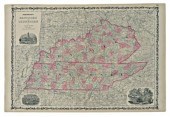 Two Kentucky and Tennessee maps:
 from A.J. Johnson's New Illustrated Family Atlas, New York, 1864, vignettes of the Nashville State House, Memphis Navy Yard, and Mammoth Cave, both hand colored, 18 x 26-1/2 in. Both slightly browned, colors faded, minor margin tears and creases. Private Collection
Two Kentucky and Tennessee maps:
Two Kentucky and Tennessee maps: from A.J. Johnson's New Illustrated Family Atlas, New York, 1864, vignettes of the Nashville State House, Memphis Navy Yard, and Mammoth Cave, both hand colored, 18 x 26-1/2 in. Both slightly browned, colors faded, minor margin tears and creases. Private Collection -
 TENNESSEE WILLIAMS. 'THE GLASS
 MENAGERIE'TENNESSEE WILLIAMS. 'THE GLASS MENAGERIE', Williams, Tennessee 'The Glass Menagerie'. New York: Random House, [1945] 8vo, publisher's rust cloth, spine lettered in gilt. First edition. Provenance: Robert McNamara Estate and Diana Byfield McNamara Book Collection
TENNESSEE WILLIAMS. 'THE GLASS
TENNESSEE WILLIAMS. 'THE GLASS MENAGERIE'TENNESSEE WILLIAMS. 'THE GLASS MENAGERIE', Williams, Tennessee 'The Glass Menagerie'. New York: Random House, [1945] 8vo, publisher's rust cloth, spine lettered in gilt. First edition. Provenance: Robert McNamara Estate and Diana Byfield McNamara Book Collection -
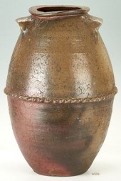 EXHIBITED WEST TENNESSEE 10
 GALLON POTTERY JAR, ATTRIB....Exhibited West Tennessee (Henderson County) ten-gallon stoneware pottery jar attributed to Tinsley W. Craven. Oval-shaped with ear handles and a crimped or raised band encircling the middle with wave design, joining both halves of the jar. Incised "10" below the rim denoting capacity. 21" H. Note: This jar was exhibited in the MADE IN TENNESSEE exhibition at the Tennessee Fine Art Center at Cheekwood, Nashville, 1971. It is featured on page 44 of the exhibition catalog as Figure 123. Biographical note: The Cravens were important potters in the Piedmont area of NC and are best known for their salt-glazed stoneware (See Smith and Rogers' Survey of Historic Pottery Making in Tennessee and Turners and Burners by Charles Zug). Around 1829, Thomas Craven (b. 1775, NC) and his family moved out of North Carolina. He and three of his sons, Balaam, John M., and Solomon moved to Clarke Co. GA. His other two sons, William R. and Tinsley W., along with his brother-in-law, John Fesmire, moved to Tennessee. They can be found in the 1830 Henderson Co. census. Tinsley W. Craven died in Henderson Co. in 1860. Research courtesy of Carole Wahler. The collection of Richard H. and Kathleen L. Hulan. Condition: Overall very good condition. Old tight spider beneath one handle, approximately 3". Some scattered firing flaws and salt glaze runs.
EXHIBITED WEST TENNESSEE 10
EXHIBITED WEST TENNESSEE 10 GALLON POTTERY JAR, ATTRIB....Exhibited West Tennessee (Henderson County) ten-gallon stoneware pottery jar attributed to Tinsley W. Craven. Oval-shaped with ear handles and a crimped or raised band encircling the middle with wave design, joining both halves of the jar. Incised "10" below the rim denoting capacity. 21" H. Note: This jar was exhibited in the MADE IN TENNESSEE exhibition at the Tennessee Fine Art Center at Cheekwood, Nashville, 1971. It is featured on page 44 of the exhibition catalog as Figure 123. Biographical note: The Cravens were important potters in the Piedmont area of NC and are best known for their salt-glazed stoneware (See Smith and Rogers' Survey of Historic Pottery Making in Tennessee and Turners and Burners by Charles Zug). Around 1829, Thomas Craven (b. 1775, NC) and his family moved out of North Carolina. He and three of his sons, Balaam, John M., and Solomon moved to Clarke Co. GA. His other two sons, William R. and Tinsley W., along with his brother-in-law, John Fesmire, moved to Tennessee. They can be found in the 1830 Henderson Co. census. Tinsley W. Craven died in Henderson Co. in 1860. Research courtesy of Carole Wahler. The collection of Richard H. and Kathleen L. Hulan. Condition: Overall very good condition. Old tight spider beneath one handle, approximately 3". Some scattered firing flaws and salt glaze runs. -
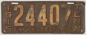 EARLY 1915 TENNESSEE LICENSE
 PLATEAn early metal State of Tennessee issued license plate reading "1915/24407/TENN/EXPIRES DEC. 31, 1915". 5 7/8" H X 15" W. Note: 1915 was the first year Tennessee issued a state license plate. Tennessee was one of the first states to issue regulated plates. (Higher-resolution photos are available at www.caseantiques.com) Condition: Overall rust and loss to paint due to exposure and age. Tear lower right margin, approx. 1", some bending to upper right corner. License plate is in original condition. Remaining paint is original.
EARLY 1915 TENNESSEE LICENSE
EARLY 1915 TENNESSEE LICENSE PLATEAn early metal State of Tennessee issued license plate reading "1915/24407/TENN/EXPIRES DEC. 31, 1915". 5 7/8" H X 15" W. Note: 1915 was the first year Tennessee issued a state license plate. Tennessee was one of the first states to issue regulated plates. (Higher-resolution photos are available at www.caseantiques.com) Condition: Overall rust and loss to paint due to exposure and age. Tear lower right margin, approx. 1", some bending to upper right corner. License plate is in original condition. Remaining paint is original. -
 LOUIS EDWARD JONES
 (AMERICAN/TENNESSEE)Louis Edward Jones (American/Tennessee, 1878-1958), "Among the Hills, Gatlinburg, Tenn.", 1938, oil on board, signed and dated lower left, signed, titled and dated en verso, 11 3/4 in. x 15 7/8 in., framed, overall 15 1/4 in. x 19 1/4 in. x 1 in.
LOUIS EDWARD JONES
LOUIS EDWARD JONES (AMERICAN/TENNESSEE)Louis Edward Jones (American/Tennessee, 1878-1958), "Among the Hills, Gatlinburg, Tenn.", 1938, oil on board, signed and dated lower left, signed, titled and dated en verso, 11 3/4 in. x 15 7/8 in., framed, overall 15 1/4 in. x 19 1/4 in. x 1 in. -
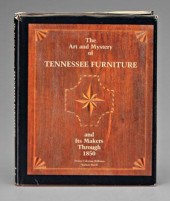
 BOOK: THE ART AND MYSTERY OF TN
 FURNITURETHE ART AND MYSTERY OF TENNESSEE FURNITURE AND ITS MAKERS THROUGH 1850, by Nathan Harsh and Derita Coleman Williams, published by the Tennessee Historical Society, Nashville, 1988. 11-1/4" x 8-3/4". Condition: Retains original dust jacket with some wear and chipping to edges and couple of light stains to back.
BOOK: THE ART AND MYSTERY OF TN
BOOK: THE ART AND MYSTERY OF TN FURNITURETHE ART AND MYSTERY OF TENNESSEE FURNITURE AND ITS MAKERS THROUGH 1850, by Nathan Harsh and Derita Coleman Williams, published by the Tennessee Historical Society, Nashville, 1988. 11-1/4" x 8-3/4". Condition: Retains original dust jacket with some wear and chipping to edges and couple of light stains to back.
...many more examples with full details are available to our members - Learn more
Easy & Visual methods to Identify & Appraise Antiques & Collectibles
EASY. FAST. ACCURATE.
Research at its best
We are here to help!
Our research tools include:

Thousands of makers marks for PORCELAIN, POTTERY CHINAWARE, FIGURINES, VASES
see details...

Thousands of marks & hallmarks for SILVER & JEWELRY, PEWTER, PRECIOUS METALS, SILVERPLATE
see details...
