Pricing Guides & Dictionary of Makers Marks for Antiques & Collectibles

Appraise and find values for
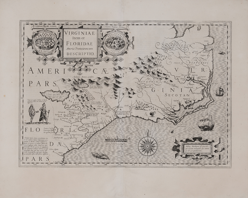
Map of the Southeast After John...
From
marks4antiques.com
- The most updated price guide and makers' marks research online
As a member, you have access to a team of experts
and assistance is always available to you for free
An example from the millions of items in our Price Guide:

Map of the Southeast After John White 17th century, "Viriginiae Item et Floridae Americae Provinciarum, Nove Descriptio," by Jodocus Hondius, after maps by...
This is an example from our
values4antiques price guide
We do not buy or sell any items
See more price guides
Check our other research services:
IDENTIFY WORLDWIDE MAKERS' MARKS & HALLMARKS
marks4ceramics:
Porcelain, Pottery, Chinaware, Figurines, Dolls, Vases...
marks4silver
:
Silver, Jewelry, Pewter, Silverplate, Copper & Bronze...
Explore other items from our
Antiques & Collectibles Price Guide
-
 BRITANNIA, VOL. I & II CAMDEN 1722Camden
[more like this]
-
 A COMPLETE SYSTEM OF GEOGRAPHY, VOL. I B
[more like this]
-
 IMPORTANT ANTIQUE ATLAS DU VOYAGE DE LA
[more like this]
-
 5 KENTUCKY AND TENNESSEE MAPS1st item: "
[more like this]
-
 A RARE ANTIQUE CIVIL WAR ERA MAP, "PRESS
[more like this]
-
 3 KY & TN MAPS: VANCE, TANNER, JOHNSON1s
[more like this]
-
 Letters Between the Sturges Brothers Mos
[more like this]
-
 4 TN & KY MAPS, 3 FRAMED1st item: "Tenne
[more like this]
-
 8 TENNESSEE MILITARY & SURVEY MAPSAssort
[more like this]
-
 A Very Large Collection of Maps, 19th/e
[more like this]
-
 16TH / 18TH C. EUROPEAN MAPS OF NEW SPAI
[more like this]
-
 A LATE MEXICAN-AMERICAN WAR ERA MAP, "MA
[more like this]
-
 A TOPOGRAPHICAL MAP OF THE ENVIRONS OF L
[more like this]
-
 11 PC. MAP COLLECTION: Comprising; 1- La
[more like this]
-
 AN IMPORTANT REPUBLIC OF TEXAS MAP, "MAP
[more like this]
-
 3 19TH CENT. AL, KY, & TN MAPS1st item:
[more like this]
-
 MAP AND ATLAS LOT, 3 PCS INCL. MELISH DI
[more like this]
-
 AN ANTIQUE RECONSTRUCTION ERA MAP, "KOSS
[more like this]
-
 FIVE 18TH CENTURY NC/TN LAND GRANTSGroup
[more like this]
-
 Archive of Documents Associated with the
[more like this]
-
 5 CIVIL WAR MAPSLot of five Civil War ma
[more like this]
-
 NATIVE AMERICAN/WESTERN U.S. EXPEDITION
[more like this]
-
 AN ANTIQUE REPUBLIC OF TEXAS MAP, "MAP O
[more like this]
-
 AN ANTIQUE REPUBLIC OF TEXAS MAP, "MAP O
[more like this]
-
 KENTUCKY MAP, 1800 PAYNE"The State of Ke
[more like this]
-
 RARE 1865 MONTANA TERRITORY MAP BY W.W.
[more like this]
-
 CIVIL WAR ARCHIVE, INCL. GEN. BATE ON DE
[more like this]
-
 2 MAPS, LA/FL AND US, LATE 18TH AND EARL
[more like this]
-
 J. SPEED 1626 MAP OF ITALY PLUS SWISS MA
[more like this]
-
 AN ANTIQUE RECONSTRUCTION ERA MAP, "TRAV
[more like this]
-
 HENRY MOUZON - MAP OF NORTH AND SOUTH CA
[more like this]
-
 A RENAISSANCE MAP, "PTOLEMY MAP OF THE W
[more like this]
-
 AN ANTIQUE POCKET MAP, "MAP OF MEXICO AN
[more like this]
-
 AN ANTEBELLUM MAP, "J. DE CORDOVA'S MAP
[more like this]
-
 4 EARLY AMERICAN MAPS: OVERTON, THIERRY,
[more like this]
-
 A LOUIS XIV MAP, "L'AMERIQUE SEPTENTRION
[more like this]
This list is limited to only a few results.
Many more items are available to our members in our
Price Guide!


