Pricing Guides & Dictionary of Makers Marks for Antiques & Collectibles
Appraise and find values for
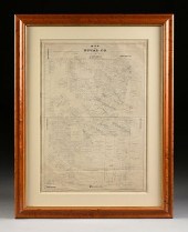
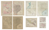
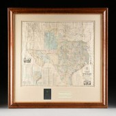
COUNTY MAP OF TEXAS, BRADLEY...
From
marks4antiques.com
- The most updated price guide and makers' marks research online
As a member, you have access to a team of experts
and assistance is always available to you for free
An example from the millions of items in our Price Guide:
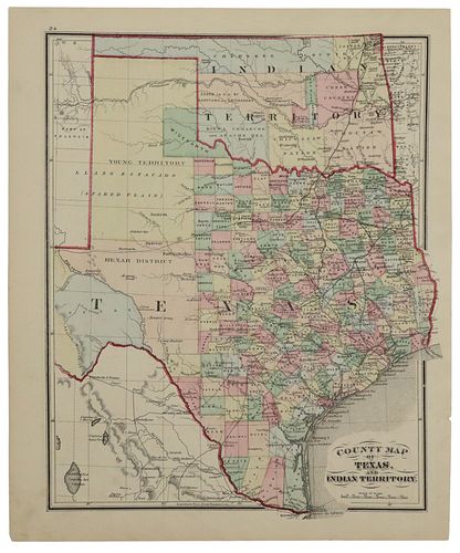
COUNTY MAP OF TEXAS, BRADLEY (ATTRIB), C. 1860"County Map of Texas and Indian Territory", attributed to Bradley & Co. consignor states c....
This is an example from our
values4antiques price guide
We do not buy or sell any items
See more price guides
Check our other research services:
IDENTIFY WORLDWIDE MAKERS' MARKS & HALLMARKS
marks4ceramics:
Porcelain, Pottery, Chinaware, Figurines, Dolls, Vases...
marks4silver
:
Silver, Jewelry, Pewter, Silverplate, Copper & Bronze...
Explore other items from our
Antiques & Collectibles Price Guide
-
 BRITANNIA, VOL. I & II CAMDEN 1722Camden
[more like this]
BRITANNIA, VOL. I & II CAMDEN 1722Camden
[more like this]
-
 A COMPLETE SYSTEM OF GEOGRAPHY, VOL. I B
[more like this]
A COMPLETE SYSTEM OF GEOGRAPHY, VOL. I B
[more like this]
-
 IMPORTANT ANTIQUE ATLAS DU VOYAGE DE LA
[more like this]
IMPORTANT ANTIQUE ATLAS DU VOYAGE DE LA
[more like this]
-
 5 KENTUCKY AND TENNESSEE MAPS1st item: "
[more like this]
5 KENTUCKY AND TENNESSEE MAPS1st item: "
[more like this]
-
 A RARE ANTIQUE CIVIL WAR ERA MAP, "PRESS
[more like this]
A RARE ANTIQUE CIVIL WAR ERA MAP, "PRESS
[more like this]
-
 3 KY & TN MAPS: VANCE, TANNER, JOHNSON1s
[more like this]
3 KY & TN MAPS: VANCE, TANNER, JOHNSON1s
[more like this]
-
 4 TN & KY MAPS, 3 FRAMED1st item: "Tenne
[more like this]
4 TN & KY MAPS, 3 FRAMED1st item: "Tenne
[more like this]
-
 AN ANTEBELLUM MAP, "J. DE CORDOVA'S MAP
[more like this]
AN ANTEBELLUM MAP, "J. DE CORDOVA'S MAP
[more like this]
-
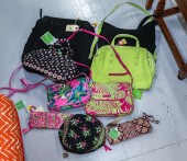 NINE VERA BRADLEY BAGS Includes a black
[more like this]
NINE VERA BRADLEY BAGS Includes a black
[more like this]
-
 8 TENNESSEE MILITARY & SURVEY MAPSAssort
[more like this]
8 TENNESSEE MILITARY & SURVEY MAPSAssort
[more like this]
-
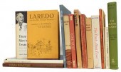 (15) TEXAS HISTORICAL REFERENCE BOOKS, L
[more like this]
(15) TEXAS HISTORICAL REFERENCE BOOKS, L
[more like this]
-
 (42) TEXANA RELATED BOOKS & PAMPHLETS(lo
[more like this]
(42) TEXANA RELATED BOOKS & PAMPHLETS(lo
[more like this]
-
 3 19TH CENT. AL, KY, & TN MAPS1st item:
[more like this]
3 19TH CENT. AL, KY, & TN MAPS1st item:
[more like this]
-
 MAP AND ATLAS LOT, 3 PCS INCL. MELISH DI
[more like this]
MAP AND ATLAS LOT, 3 PCS INCL. MELISH DI
[more like this]
-
 A Very Large Collection of Maps, 19th/e
[more like this]
A Very Large Collection of Maps, 19th/e
[more like this]
-
 AN ANTIQUE CADASTRAL MAP, "MAP OF DUVAL
[more like this]
AN ANTIQUE CADASTRAL MAP, "MAP OF DUVAL
[more like this]
-
 AN ANTIQUE RECONSTRUCTION ERA MAP, "TRAV
[more like this]
AN ANTIQUE RECONSTRUCTION ERA MAP, "TRAV
[more like this]
-
 AN ANTIQUE REPUBLIC OF TEXAS MAP, "MAP O
[more like this]
AN ANTIQUE REPUBLIC OF TEXAS MAP, "MAP O
[more like this]
-
 16TH / 18TH C. EUROPEAN MAPS OF NEW SPAI
[more like this]
16TH / 18TH C. EUROPEAN MAPS OF NEW SPAI
[more like this]
-
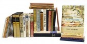
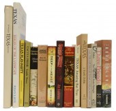 (15) BOOKS: TEXAS FICTION, HISTORY, PHOT
[more like this]
(15) BOOKS: TEXAS FICTION, HISTORY, PHOT
[more like this]
-
 TWO ANTIQUE ANTEBELLUM MAPS, "MAP OF TEX
[more like this]
TWO ANTIQUE ANTEBELLUM MAPS, "MAP OF TEX
[more like this]
-
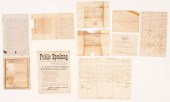 10 PCS 19TH C. TN EPHEMERA, INCL. GOVERN
[more like this]
10 PCS 19TH C. TN EPHEMERA, INCL. GOVERN
[more like this]
-
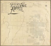 AN ANTIQUE MAP, "MAP OF ABILENE," GALVES
[more like this]
AN ANTIQUE MAP, "MAP OF ABILENE," GALVES
[more like this]
-
 A TOPOGRAPHICAL MAP OF THE ENVIRONS OF L
[more like this]
A TOPOGRAPHICAL MAP OF THE ENVIRONS OF L
[more like this]
-
 11 PC. MAP COLLECTION: Comprising; 1- La
[more like this]
11 PC. MAP COLLECTION: Comprising; 1- La
[more like this]
-
 (6) ANTIQUE TEXAS MAPS<br>(lot of 6)&nbs
[more like this]
(6) ANTIQUE TEXAS MAPS<br>(lot of 6)&nbs
[more like this]
-
 Autographs of WWII Generals Four 4-Star
[more like this]
Autographs of WWII Generals Four 4-Star
[more like this]
-
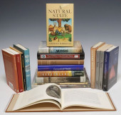 (19) BOOKS, TEXAS SUBJECTS & MORE, M
[more like this]
(19) BOOKS, TEXAS SUBJECTS & MORE, M
[more like this]
-
 AN ANTIQUE MAP, "A.R. ROESSLER'S LATEST
[more like this]
AN ANTIQUE MAP, "A.R. ROESSLER'S LATEST
[more like this]
-
 GROUP OF MIDDLE TN EPHEMERA INC. SLAVE S
[more like this]
GROUP OF MIDDLE TN EPHEMERA INC. SLAVE S
[more like this]
-
 FIVE 18TH CENTURY NC/TN LAND GRANTSGroup
[more like this]
FIVE 18TH CENTURY NC/TN LAND GRANTSGroup
[more like this]
-
 A LATE MEXICAN-AMERICAN WAR ERA MAP, "MA
[more like this]
A LATE MEXICAN-AMERICAN WAR ERA MAP, "MA
[more like this]
-
 AN IMPORTANT REPUBLIC OF TEXAS MAP, "MAP
[more like this]
AN IMPORTANT REPUBLIC OF TEXAS MAP, "MAP
[more like this]
-
 AN ANTIQUE RECONSTRUCTION ERA MAP, "KOSS
[more like this]
AN ANTIQUE RECONSTRUCTION ERA MAP, "KOSS
[more like this]
-
 5 CIVIL WAR MAPSLot of five Civil War ma
[more like this]
5 CIVIL WAR MAPSLot of five Civil War ma
[more like this]
-
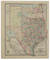 COUNTY MAP OF TEXAS, BRADLEY (ATTRIB), C
[more like this]
COUNTY MAP OF TEXAS, BRADLEY (ATTRIB), C
[more like this]
This list is limited to only a few results.
Many more items are available to our members in our
Price Guide!
Ideal research tools for Collectors, Personal Property Appraisers, Antiques & Collectibles
Dealers, Auction Houses, Museums, eBayers or
other online
sellers (Rubylane, Etsy etc) and curious minds interested in appraising & identifying collectibles

EASY. FAST. ACCURATE.
Research at its best

Our research tools include:


