Pricing Guides & Dictionary of Makers Marks for Antiques & Collectibles
Appraise and find values for
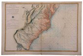
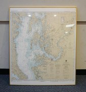
DE SARTINE'S MAP OF CHESAPEAKE BAY,...
From
marks4antiques.com
- The most updated price guide and makers' marks research online
As a member, you have access to a team of experts
and assistance is always available to you for free
An example from the millions of items in our Price Guide:
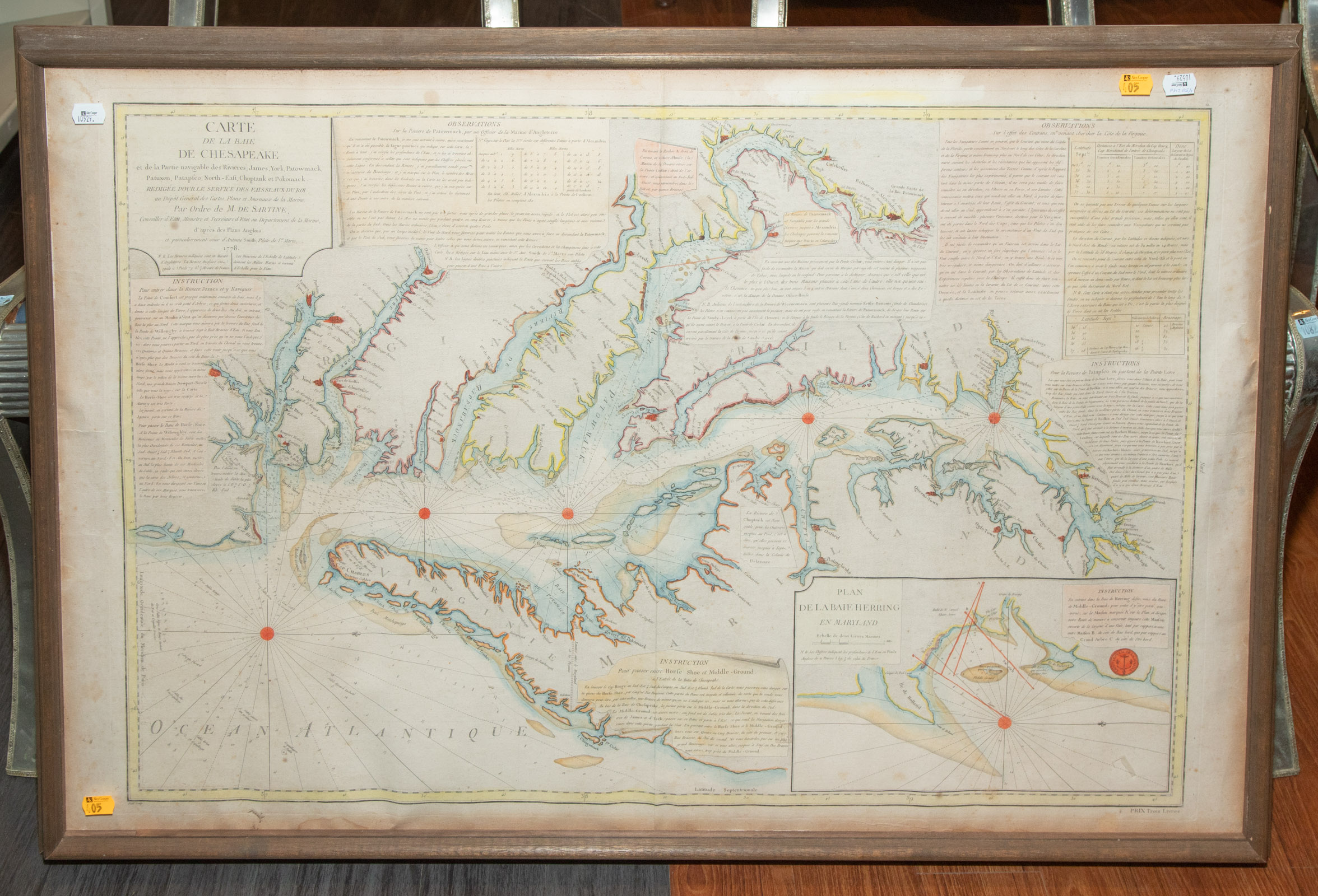
DE SARTINE'S MAP OF CHESAPEAKE BAY, 1778 Antoine De Sartine; "Carte de la Baie de Chesapeake et de la partie navigable des rivieres, James, York,...
This is an example from our
values4antiques price guide
We do not buy or sell any items
See more price guides
Check our other research services:
IDENTIFY WORLDWIDE MAKERS' MARKS & HALLMARKS
marks4ceramics:
Porcelain, Pottery, Chinaware, Figurines, Dolls, Vases...
marks4silver
:
Silver, Jewelry, Pewter, Silverplate, Copper & Bronze...
Explore other items from our
Antiques & Collectibles Price Guide
-
 BRITANNIA, VOL. I & II CAMDEN 1722Camden
[more like this]
BRITANNIA, VOL. I & II CAMDEN 1722Camden
[more like this]
-
 IMPORTANT ANTIQUE ATLAS DU VOYAGE DE LA
[more like this]
IMPORTANT ANTIQUE ATLAS DU VOYAGE DE LA
[more like this]
-
 A COMPLETE SYSTEM OF GEOGRAPHY, VOL. I B
[more like this]
A COMPLETE SYSTEM OF GEOGRAPHY, VOL. I B
[more like this]
-
 5 KENTUCKY AND TENNESSEE MAPS1st item: "
[more like this]
5 KENTUCKY AND TENNESSEE MAPS1st item: "
[more like this]
-
 A RARE ANTIQUE CIVIL WAR ERA MAP, "PRESS
[more like this]
A RARE ANTIQUE CIVIL WAR ERA MAP, "PRESS
[more like this]
-
 3 KY & TN MAPS: VANCE, TANNER, JOHNSON1s
[more like this]
3 KY & TN MAPS: VANCE, TANNER, JOHNSON1s
[more like this]
-
 DE SARTINE'S MAP OF CHESAPEAKE BAY, 1778
[more like this]
DE SARTINE'S MAP OF CHESAPEAKE BAY, 1778
[more like this]
-
 A Very Large Collection of Maps, 19th/e
[more like this]
A Very Large Collection of Maps, 19th/e
[more like this]
-
 4 TN & KY MAPS, 3 FRAMED1st item: "Tenne
[more like this]
4 TN & KY MAPS, 3 FRAMED1st item: "Tenne
[more like this]
-
 16TH / 18TH C. EUROPEAN MAPS OF NEW SPAI
[more like this]
16TH / 18TH C. EUROPEAN MAPS OF NEW SPAI
[more like this]
-
 8 TENNESSEE MILITARY & SURVEY MAPSAssort
[more like this]
8 TENNESSEE MILITARY & SURVEY MAPSAssort
[more like this]
-
 A LATE MEXICAN-AMERICAN WAR ERA MAP, "MA
[more like this]
A LATE MEXICAN-AMERICAN WAR ERA MAP, "MA
[more like this]
-
 A TOPOGRAPHICAL MAP OF THE ENVIRONS OF L
[more like this]
A TOPOGRAPHICAL MAP OF THE ENVIRONS OF L
[more like this]
-
 11 PC. MAP COLLECTION: Comprising; 1- La
[more like this]
11 PC. MAP COLLECTION: Comprising; 1- La
[more like this]
-
 Rare Topographic Civil War Map Birds Eye
[more like this]
Rare Topographic Civil War Map Birds Eye
[more like this]
-
 AN IMPORTANT REPUBLIC OF TEXAS MAP, "MAP
[more like this]
AN IMPORTANT REPUBLIC OF TEXAS MAP, "MAP
[more like this]
-
 AN ANTIQUE RECONSTRUCTION ERA MAP, "KOSS
[more like this]
AN ANTIQUE RECONSTRUCTION ERA MAP, "KOSS
[more like this]
-
 3 19TH CENT. AL, KY, & TN MAPS1st item:
[more like this]
3 19TH CENT. AL, KY, & TN MAPS1st item:
[more like this]
-
 MAP AND ATLAS LOT, 3 PCS INCL. MELISH DI
[more like this]
MAP AND ATLAS LOT, 3 PCS INCL. MELISH DI
[more like this]
-
 5 CIVIL WAR MAPSLot of five Civil War ma
[more like this]
5 CIVIL WAR MAPSLot of five Civil War ma
[more like this]
-
 NATIVE AMERICAN/WESTERN U.S. EXPEDITION
[more like this]
NATIVE AMERICAN/WESTERN U.S. EXPEDITION
[more like this]
-
 EMANUEL BOWEN MAP NORTH & SOUTH CAROLINA
[more like this]
EMANUEL BOWEN MAP NORTH & SOUTH CAROLINA
[more like this]
-
 SARTINE - MAP OF THE ATLANTIC COAST, 177
[more like this]
SARTINE - MAP OF THE ATLANTIC COAST, 177
[more like this]
-
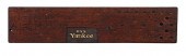 USS Yankee Naval Cruiser on the Cuban Bl
[more like this]
USS Yankee Naval Cruiser on the Cuban Bl
[more like this]
-
 AN ANTIQUE REPUBLIC OF TEXAS MAP, "MAP O
[more like this]
AN ANTIQUE REPUBLIC OF TEXAS MAP, "MAP O
[more like this]
-
 AN ANTIQUE REPUBLIC OF TEXAS MAP, "MAP O
[more like this]
AN ANTIQUE REPUBLIC OF TEXAS MAP, "MAP O
[more like this]
-
 RARE 1865 MONTANA TERRITORY MAP BY W.W.
[more like this]
RARE 1865 MONTANA TERRITORY MAP BY W.W.
[more like this]
-
 J. EUGENE GARDNER (AMERICAN 1904-1999) P
[more like this]
J. EUGENE GARDNER (AMERICAN 1904-1999) P
[more like this]
-
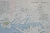 ENGLAND IN AMERICA: THE CHESAPEAKE BAY F
[more like this]
ENGLAND IN AMERICA: THE CHESAPEAKE BAY F
[more like this]
-
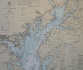 CHESAPEAKE BAY, SANDY POINT TO SUSQUEHAN
[more like this]
CHESAPEAKE BAY, SANDY POINT TO SUSQUEHAN
[more like this]
-
 CHESAPEAKE BAY, COVE POINT TO SANDY POIN
[more like this]
CHESAPEAKE BAY, COVE POINT TO SANDY POIN
[more like this]
-
 After J. C. Schetky and R. Paton (Britis
[more like this]
After J. C. Schetky and R. Paton (Britis
[more like this]
-
 LOT OF 5 WALTHERS READY TO RUN PASSENGER
[more like this]
LOT OF 5 WALTHERS READY TO RUN PASSENGER
[more like this]
-
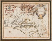 JOHN SPEED 1676 MAP OF VIRGINIA, MARYLAN
[more like this]
JOHN SPEED 1676 MAP OF VIRGINIA, MARYLAN
[more like this]
-
 AN ANTIQUE RECONSTRUCTION ERA MAP, "TRAV
[more like this]
AN ANTIQUE RECONSTRUCTION ERA MAP, "TRAV
[more like this]
-
 A RENAISSANCE MAP, "PTOLEMY MAP OF THE W
[more like this]
A RENAISSANCE MAP, "PTOLEMY MAP OF THE W
[more like this]
This list is limited to only a few results.
Many more items are available to our members in our
Price Guide!
Ideal research tools for Collectors, Personal Property Appraisers, Antiques & Collectibles
Dealers, Auction Houses, Museums, eBayers or
other online
sellers (Rubylane, Etsy etc) and curious minds interested in appraising & identifying collectibles

EASY. FAST. ACCURATE.
Research at its best

Our research tools include:


