Pricing Guides & Dictionary of Makers Marks for Antiques & Collectibles
Appraise and find values for
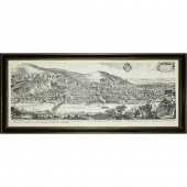
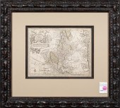
MATTHAUS MERIAN, CHINA MAP,...
From
marks4antiques.com
- The most updated price guide and makers' marks research online
As a member, you have access to a team of experts
and assistance is always available to you for free
An example from the millions of items in our Price Guide:
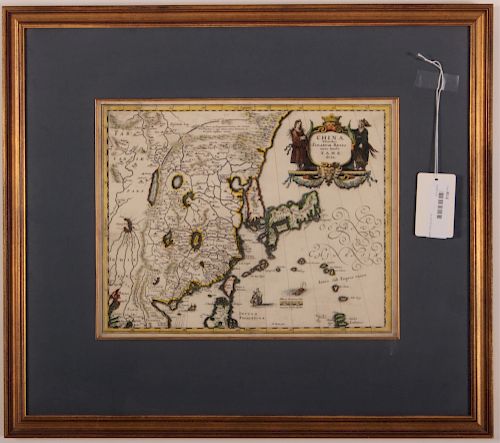
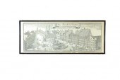
MATTHAUS MERIAN, CHINA MAP, C.1649Matthaus Merian, Swiss, 1593-1650, c.1649, China Veteribus Sinarum Regio nunc Incolis Tame dicta , map of China and Japan...
This is an example from our
values4antiques price guide
We do not buy or sell any items
See more price guides
Check our other research services:
IDENTIFY WORLDWIDE MAKERS' MARKS & HALLMARKS
marks4ceramics:
Porcelain, Pottery, Chinaware, Figurines, Dolls, Vases...
marks4silver
:
Silver, Jewelry, Pewter, Silverplate, Copper & Bronze...
Explore other items from our
Antiques & Collectibles Price Guide
-
 BRITANNIA, VOL. I & II CAMDEN 1722Camden
[more like this]
BRITANNIA, VOL. I & II CAMDEN 1722Camden
[more like this]
-
 A COMPLETE SYSTEM OF GEOGRAPHY, VOL. I B
[more like this]
A COMPLETE SYSTEM OF GEOGRAPHY, VOL. I B
[more like this]
-
 IMPORTANT ANTIQUE ATLAS DU VOYAGE DE LA
[more like this]
IMPORTANT ANTIQUE ATLAS DU VOYAGE DE LA
[more like this]
-
 5 KENTUCKY AND TENNESSEE MAPS1st item: "
[more like this]
5 KENTUCKY AND TENNESSEE MAPS1st item: "
[more like this]
-
 MATTHAUS MERIAN, CHINA MAP, C.1649Mattha
[more like this]
MATTHAUS MERIAN, CHINA MAP, C.1649Mattha
[more like this]
-
 A RARE ANTIQUE CIVIL WAR ERA MAP, "PRESS
[more like this]
A RARE ANTIQUE CIVIL WAR ERA MAP, "PRESS
[more like this]
-
 3 KY & TN MAPS: VANCE, TANNER, JOHNSON1s
[more like this]
3 KY & TN MAPS: VANCE, TANNER, JOHNSON1s
[more like this]
-
 MATTHAUS MERIAN THE ELDER (SWISS, 1593 -
[more like this]
MATTHAUS MERIAN THE ELDER (SWISS, 1593 -
[more like this]
-
 4 TN & KY MAPS, 3 FRAMED1st item: "Tenne
[more like this]
4 TN & KY MAPS, 3 FRAMED1st item: "Tenne
[more like this]
-
 A Very Large Collection of Maps, 19th/e
[more like this]
A Very Large Collection of Maps, 19th/e
[more like this]
-
 8 TENNESSEE MILITARY & SURVEY MAPSAssort
[more like this]
8 TENNESSEE MILITARY & SURVEY MAPSAssort
[more like this]
-
 MATTHAUS MERIAN,C.1638, INDIA ORIENTALIS
[more like this]
MATTHAUS MERIAN,C.1638, INDIA ORIENTALIS
[more like this]
-
 11 PC. MAP COLLECTION: Comprising; 1- La
[more like this]
11 PC. MAP COLLECTION: Comprising; 1- La
[more like this]
-
 PRINT, AFTER MATTHAUS MERIAN After Matth
[more like this]
PRINT, AFTER MATTHAUS MERIAN After Matth
[more like this]
-
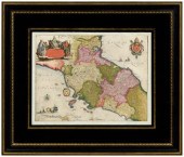 17th century map of Italy, Stato Della C
[more like this]
17th century map of Italy, Stato Della C
[more like this]
-
 A TOPOGRAPHICAL MAP OF THE ENVIRONS OF L
[more like this]
A TOPOGRAPHICAL MAP OF THE ENVIRONS OF L
[more like this]
-
 16TH / 18TH C. EUROPEAN MAPS OF NEW SPAI
[more like this]
16TH / 18TH C. EUROPEAN MAPS OF NEW SPAI
[more like this]
-
 A LATE MEXICAN-AMERICAN WAR ERA MAP, "MA
[more like this]
A LATE MEXICAN-AMERICAN WAR ERA MAP, "MA
[more like this]
-
 AN IMPORTANT REPUBLIC OF TEXAS MAP, "MAP
[more like this]
AN IMPORTANT REPUBLIC OF TEXAS MAP, "MAP
[more like this]
-
 AN ANTIQUE RECONSTRUCTION ERA MAP, "KOSS
[more like this]
AN ANTIQUE RECONSTRUCTION ERA MAP, "KOSS
[more like this]
-
 3 19TH CENT. AL, KY, & TN MAPS1st item:
[more like this]
3 19TH CENT. AL, KY, & TN MAPS1st item:
[more like this]
-
 MAP AND ATLAS LOT, 3 PCS INCL. MELISH DI
[more like this]
MAP AND ATLAS LOT, 3 PCS INCL. MELISH DI
[more like this]
-
 5 CIVIL WAR MAPSLot of five Civil War ma
[more like this]
5 CIVIL WAR MAPSLot of five Civil War ma
[more like this]
-
 MAP: GEORG MATTHäUS SEUTTER (GERMAN, 167
[more like this]
MAP: GEORG MATTHäUS SEUTTER (GERMAN, 167
[more like this]
-
 NATIVE AMERICAN/WESTERN U.S. EXPEDITION
[more like this]
NATIVE AMERICAN/WESTERN U.S. EXPEDITION
[more like this]
-
 MAP: GEORG MATTHäUS SEUTTER (GERMAN, 167
[more like this]
MAP: GEORG MATTHäUS SEUTTER (GERMAN, 167
[more like this]
-
 [A PRIVATE SCOTTISH COLLECTION, EDINBURG
[more like this]
[A PRIVATE SCOTTISH COLLECTION, EDINBURG
[more like this]
-
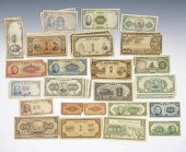 LOT OF CHINESE PAPER CURRENCY, 1935 - 19
[more like this]
LOT OF CHINESE PAPER CURRENCY, 1935 - 19
[more like this]
-
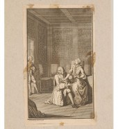 Four 17th and 18th century European engr
[more like this]
Four 17th and 18th century European engr
[more like this]
-
 DER MARCKT ZU MUNCHEN AFTER MATTHAUS MER
[more like this]
DER MARCKT ZU MUNCHEN AFTER MATTHAUS MER
[more like this]
-
 RARE 1865 MONTANA TERRITORY MAP BY W.W.
[more like this]
RARE 1865 MONTANA TERRITORY MAP BY W.W.
[more like this]
-
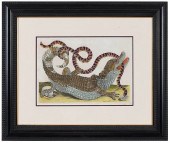 MARIA SIBYLLA MERIAN(German, 1647?1717)
[more like this]
MARIA SIBYLLA MERIAN(German, 1647?1717)
[more like this]
-
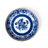 GILT-DECORATED BLUE AND WHITE 'MERIA SYB
[more like this]
GILT-DECORATED BLUE AND WHITE 'MERIA SYB
[more like this]
-
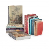
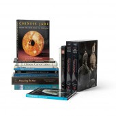 COLLECTION OF ART REFERENCE BOOKS
ON ASI
[more like this]
COLLECTION OF ART REFERENCE BOOKS
ON ASI
[more like this]
-
 MAP, GEORG MATTHAUS SEUTTER Georg Mattha
[more like this]
MAP, GEORG MATTHAUS SEUTTER Georg Mattha
[more like this]
-
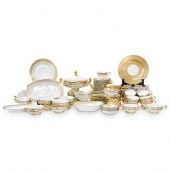 (115 PC) HUTSCHENREUTHER SELB BAVARIA PO
[more like this]
(115 PC) HUTSCHENREUTHER SELB BAVARIA PO
[more like this]
This list is limited to only a few results.
Many more items are available to our members in our
Price Guide!
Ideal research tools for Collectors, Personal Property Appraisers, Antiques & Collectibles
Dealers, Auction Houses, Museums, eBayers or
other online
sellers (Rubylane, Etsy etc) and curious minds interested in appraising & identifying collectibles

EASY. FAST. ACCURATE.
Research at its best

Our research tools include:


