Pricing Guides & Dictionary of Makers Marks for Antiques & Collectibles
Appraise and find values for
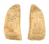
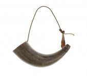
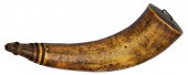
NEW YORK SCRIMSHAW MAP POWDER HORN,...
From
marks4antiques.com
- The most updated price guide and makers' marks research online
As a member, you have access to a team of experts
and assistance is always available to you for free
An example from the millions of items in our Price Guide:
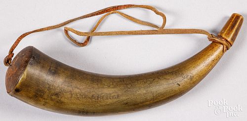
NEW YORK SCRIMSHAW MAP POWDER HORN, DATED 1768New York scrimshaw map powder horn, dated 1768, with various locations identified as Fort George, Lake...
This is an example from our
values4antiques price guide
We do not buy or sell any items
See more price guides
Check our other research services:
IDENTIFY WORLDWIDE MAKERS' MARKS & HALLMARKS
marks4ceramics:
Porcelain, Pottery, Chinaware, Figurines, Dolls, Vases...
marks4silver
:
Silver, Jewelry, Pewter, Silverplate, Copper & Bronze...
Explore other items from our
Antiques & Collectibles Price Guide
-
 BRITANNIA, VOL. I & II CAMDEN 1722Camden
[more like this]
BRITANNIA, VOL. I & II CAMDEN 1722Camden
[more like this]
-
 A COMPLETE SYSTEM OF GEOGRAPHY, VOL. I B
[more like this]
A COMPLETE SYSTEM OF GEOGRAPHY, VOL. I B
[more like this]
-
 IMPORTANT ANTIQUE ATLAS DU VOYAGE DE LA
[more like this]
IMPORTANT ANTIQUE ATLAS DU VOYAGE DE LA
[more like this]
-
 5 KENTUCKY AND TENNESSEE MAPS1st item: "
[more like this]
5 KENTUCKY AND TENNESSEE MAPS1st item: "
[more like this]
-
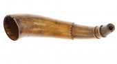
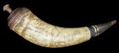
 (17) ANTIQUE AMERICAN AND ENGLISH POWDER
[more like this]
(17) ANTIQUE AMERICAN AND ENGLISH POWDER
[more like this]
-
 1775 SCRIMSHAW & CARVED STEER HORN POWDE
[more like this]
1775 SCRIMSHAW & CARVED STEER HORN POWDE
[more like this]
-
 3 KY & TN MAPS: VANCE, TANNER, JOHNSON1s
[more like this]
3 KY & TN MAPS: VANCE, TANNER, JOHNSON1s
[more like this]
-
 PAIR OF EXCEPTIONALLY RARE AND HISTORICA
[more like this]
PAIR OF EXCEPTIONALLY RARE AND HISTORICA
[more like this]
-
 LRG GRP: BOOKS ON AFRICA AND AFRICAN ART
[more like this]
LRG GRP: BOOKS ON AFRICA AND AFRICAN ART
[more like this]
-
 4 TN & KY MAPS, 3 FRAMED1st item: "Tenne
[more like this]
4 TN & KY MAPS, 3 FRAMED1st item: "Tenne
[more like this]
-
 A RARE ANTIQUE CIVIL WAR ERA MAP, "PRESS
[more like this]
A RARE ANTIQUE CIVIL WAR ERA MAP, "PRESS
[more like this]
-
 A LATE MEXICAN-AMERICAN WAR ERA MAP, "MA
[more like this]
A LATE MEXICAN-AMERICAN WAR ERA MAP, "MA
[more like this]
-
 8 TENNESSEE MILITARY & SURVEY MAPSAssort
[more like this]
8 TENNESSEE MILITARY & SURVEY MAPSAssort
[more like this]
-
 A Very Large Collection of Maps, 19th/e
[more like this]
A Very Large Collection of Maps, 19th/e
[more like this]
-
 LATE 1800S BUFFALO POWDER HORN W/ SHOULD
[more like this]
LATE 1800S BUFFALO POWDER HORN W/ SHOULD
[more like this]
-
 16TH / 18TH C. EUROPEAN MAPS OF NEW SPAI
[more like this]
16TH / 18TH C. EUROPEAN MAPS OF NEW SPAI
[more like this]
-
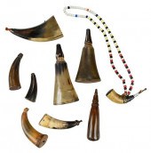 NINE SMALL POWDER HORNS AND FLASKS19th c
[more like this]
NINE SMALL POWDER HORNS AND FLASKS19th c
[more like this]
-
 AN IMPORTANT REPUBLIC OF TEXAS MAP, "MAP
[more like this]
AN IMPORTANT REPUBLIC OF TEXAS MAP, "MAP
[more like this]
-
 THOMAS KOETHER (NY, FL B. 1940) "RED PRO
[more like this]
THOMAS KOETHER (NY, FL B. 1940) "RED PRO
[more like this]
-
 THOMAS KOETHER (NY, FL B. 1940) "CREVICE
[more like this]
THOMAS KOETHER (NY, FL B. 1940) "CREVICE
[more like this]
-
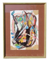 THOMAS KOETHER (NY B 1940) "SOMETHING FE
[more like this]
THOMAS KOETHER (NY B 1940) "SOMETHING FE
[more like this]
-
 NATIVE AMERICAN/WESTERN U.S. EXPEDITION
[more like this]
NATIVE AMERICAN/WESTERN U.S. EXPEDITION
[more like this]
-
 A TOPOGRAPHICAL MAP OF THE ENVIRONS OF L
[more like this]
A TOPOGRAPHICAL MAP OF THE ENVIRONS OF L
[more like this]
-
 11 PC. MAP COLLECTION: Comprising; 1- La
[more like this]
11 PC. MAP COLLECTION: Comprising; 1- La
[more like this]
-
 3 19TH CENT. AL, KY, & TN MAPS1st item:
[more like this]
3 19TH CENT. AL, KY, & TN MAPS1st item:
[more like this]
-
 AN ANTIQUE RECONSTRUCTION ERA MAP, "KOSS
[more like this]
AN ANTIQUE RECONSTRUCTION ERA MAP, "KOSS
[more like this]
-
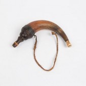
 French and Indian War Map Horn--Forbes T
[more like this]
French and Indian War Map Horn--Forbes T
[more like this]
-
 MAP AND ATLAS LOT, 3 PCS INCL. MELISH DI
[more like this]
MAP AND ATLAS LOT, 3 PCS INCL. MELISH DI
[more like this]
-
 5 CIVIL WAR MAPSLot of five Civil War ma
[more like this]
5 CIVIL WAR MAPSLot of five Civil War ma
[more like this]
-
 SCRIMSHAW DECORATED POWDER HORN, AMERICA
[more like this]
SCRIMSHAW DECORATED POWDER HORN, AMERICA
[more like this]
-
 LARGE ANTIQUE POWDER HORN WITH BONE TIPA
[more like this]
LARGE ANTIQUE POWDER HORN WITH BONE TIPA
[more like this]
-
 4 EARLY AMERICAN MAPS: OVERTON, THIERRY,
[more like this]
4 EARLY AMERICAN MAPS: OVERTON, THIERRY,
[more like this]
-
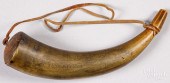 NEW YORK SCRIMSHAW MAP POWDER HORN, DATE
[more like this]
NEW YORK SCRIMSHAW MAP POWDER HORN, DATE
[more like this]
-
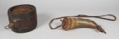 POWDER KEG AND POWDER HORNPowder keg and
[more like this]
POWDER KEG AND POWDER HORNPowder keg and
[more like this]
-
 AN ANTIQUE RECONSTRUCTION ERA MAP, "TRAV
[more like this]
AN ANTIQUE RECONSTRUCTION ERA MAP, "TRAV
[more like this]
-
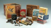 Assorted shotgun shells and equipment: b
[more like this]
Assorted shotgun shells and equipment: b
[more like this]
This list is limited to only a few results.
Many more items are available to our members in our
Price Guide!
Ideal research tools for Collectors, Personal Property Appraisers, Antiques & Collectibles
Dealers, Auction Houses, Museums, eBayers or
other online
sellers (Rubylane, Etsy etc) and curious minds interested in appraising & identifying collectibles

EASY. FAST. ACCURATE.
Research at its best

Our research tools include:


