Pricing Guides & Dictionary of Makers Marks for Antiques & Collectibles
A few examples of appraisal values for
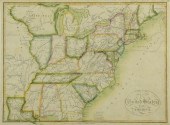
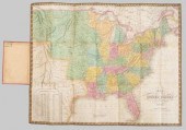
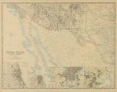
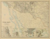
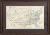
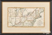
1853 MAP OF UNITED STATES
Search our price guide for your own treasures
-
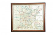
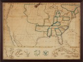
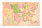 1847 MAP OF UNITED STATES.
 Published New York, 1847, by Pratt, Woodford & Co., hand colored engraved map on paper. "Olney's Outline Map for Common Schools and General Use" showing the United States and Territories with corresponding populations. Folded with hanging tabs, backed on linen. Stains and edge wear. 28.75"h. 44"w.
1847 MAP OF UNITED STATES.
1847 MAP OF UNITED STATES. Published New York, 1847, by Pratt, Woodford & Co., hand colored engraved map on paper. "Olney's Outline Map for Common Schools and General Use" showing the United States and Territories with corresponding populations. Folded with hanging tabs, backed on linen. Stains and edge wear. 28.75"h. 44"w. -
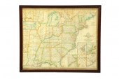
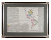
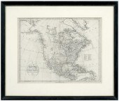
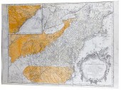
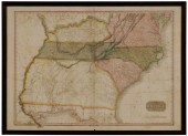 19th Century Map of the
 Southeastern United States "United States of America, Southern Part", drawn by L. Hebert under the direction of John Pinkerton, Philadelphia, 1818, published by Thomas Dobson in the first American edition of Pinkerton's Modern Atlas, showing states and territories in the Southeastern United States, excluding southern Florida, hand-colored, 21-3/4 x 30-1/4 in. (sight), modern wood frame
19th Century Map of the
19th Century Map of the Southeastern United States "United States of America, Southern Part", drawn by L. Hebert under the direction of John Pinkerton, Philadelphia, 1818, published by Thomas Dobson in the first American edition of Pinkerton's Modern Atlas, showing states and territories in the Southeastern United States, excluding southern Florida, hand-colored, 21-3/4 x 30-1/4 in. (sight), modern wood frame -
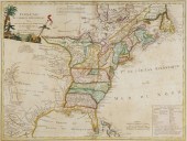
 "A MAP OF THE UNITED STATES OF
 AMERICA AS SETTLED BY THE PEACE OF 1783" 1785 ENGRAVING, 9.25" X 11.25". UNFRAMED."A MAP OF THE UNITED STATES OF AMERICA AS SETTLED BY THE PEACE OF 1783", 1785, Published by John Fielding, London. A fairly detailed rendering of the newly minted United States of America, showing North Carolina, South Carolina, Georgia and Virginia extending west to the Mississippi. Dimensions: Engraving, 9.25" x 11.25". Unframed.
"A MAP OF THE UNITED STATES OF
"A MAP OF THE UNITED STATES OF AMERICA AS SETTLED BY THE PEACE OF 1783" 1785 ENGRAVING, 9.25" X 11.25". UNFRAMED."A MAP OF THE UNITED STATES OF AMERICA AS SETTLED BY THE PEACE OF 1783", 1785, Published by John Fielding, London. A fairly detailed rendering of the newly minted United States of America, showing North Carolina, South Carolina, Georgia and Virginia extending west to the Mississippi. Dimensions: Engraving, 9.25" x 11.25". Unframed. -
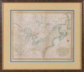
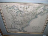
 1815 MAP OF THE UNITED STATES,
 INCLUDINGLouisiana. Published by Riley, New York. Black and white. Shows fading and discoloration, some creasing. Modern frame, UV glass. Sight size 16 1/2" x 18 1/2", overall 24" x 27 1/2".
1815 MAP OF THE UNITED STATES,
1815 MAP OF THE UNITED STATES, INCLUDINGLouisiana. Published by Riley, New York. Black and white. Shows fading and discoloration, some creasing. Modern frame, UV glass. Sight size 16 1/2" x 18 1/2", overall 24" x 27 1/2". -
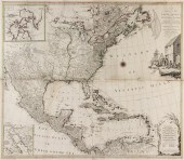
 JOHN MELISH 1815 UNITED STATES OF
 AMERICA MAP"Map of the United States of America", by John Melish, 1815. From "The Traveller_s Directory through the United States" by John Melish. Copper plate engraving with hand colored outlines of the United States extending from the lower territories of Canada, including Quebec, top right, to the northern areas of Florida, including St. Augustine, lower center, depicting towns, roads, territory lines, names of territories, forts, rivers, bodies of water, and mountains. "Unexplored Country" notation, top left of Missouri Territory. Title, explanations, and scale of miles, lower right. Map surrounded by scale notations and triple line border. Image - 13 1/2" H x 17 1/2" W. Framed - 18 1/2" H x 23 1/4" W. Early 19th century. Provenance: Collection of Charles and Ann Wells, Nashville, Tennessee. (Higher-resolution photos are available at www.caseantiques.com) Condition: Areas of toning, largest 1", top left of sheet. Minute foxing spots, on surface of sheet. Not examined out of frame.
JOHN MELISH 1815 UNITED STATES OF
JOHN MELISH 1815 UNITED STATES OF AMERICA MAP"Map of the United States of America", by John Melish, 1815. From "The Traveller_s Directory through the United States" by John Melish. Copper plate engraving with hand colored outlines of the United States extending from the lower territories of Canada, including Quebec, top right, to the northern areas of Florida, including St. Augustine, lower center, depicting towns, roads, territory lines, names of territories, forts, rivers, bodies of water, and mountains. "Unexplored Country" notation, top left of Missouri Territory. Title, explanations, and scale of miles, lower right. Map surrounded by scale notations and triple line border. Image - 13 1/2" H x 17 1/2" W. Framed - 18 1/2" H x 23 1/4" W. Early 19th century. Provenance: Collection of Charles and Ann Wells, Nashville, Tennessee. (Higher-resolution photos are available at www.caseantiques.com) Condition: Areas of toning, largest 1", top left of sheet. Minute foxing spots, on surface of sheet. Not examined out of frame. -
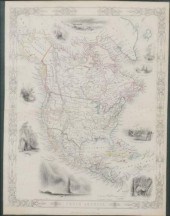
 A NEW MAP OF THE UNITED STATES UPON
 WHICH ARE DELINEATED ITS VAST WORKS OF INTERNAL COMMUNICATION ROUTES ACROSS THE CONTINENT. By Wellington Williams. Philadelphia: Lippincott Grambo and Company 1854 lithograph with original outline color. Includes inset maps of Niagara Falls Cuba and the western U.S. 25 1/4''h. 30 1/4''w. (sight) in a wooden frame 29''h. 34''w. Even toning fold lines (some with minor separation) chips and tears at the margins.
A NEW MAP OF THE UNITED STATES UPON
A NEW MAP OF THE UNITED STATES UPON WHICH ARE DELINEATED ITS VAST WORKS OF INTERNAL COMMUNICATION ROUTES ACROSS THE CONTINENT. By Wellington Williams. Philadelphia: Lippincott Grambo and Company 1854 lithograph with original outline color. Includes inset maps of Niagara Falls Cuba and the western U.S. 25 1/4''h. 30 1/4''w. (sight) in a wooden frame 29''h. 34''w. Even toning fold lines (some with minor separation) chips and tears at the margins. -
 MITCHELL'S NEW NATIONAL MAP, UNITED
 STATES, NORTH AMERICAN BRITISH PROVINCES Sandwich Islands, Mexico and Central America, Cuba, West Indies, Philadelphia, published by S. Augustus Mitchell. 1856
MITCHELL'S NEW NATIONAL MAP, UNITED
MITCHELL'S NEW NATIONAL MAP, UNITED STATES, NORTH AMERICAN BRITISH PROVINCES Sandwich Islands, Mexico and Central America, Cuba, West Indies, Philadelphia, published by S. Augustus Mitchell. 1856 -
 Mitchell's pocket map, United
 States, "Map of the United States, constructed from the latest authorities", by S.A. Mitchell, Philadelphia, 1831, folding map with original cover, showing boundaries of eastern states, western territories, and parts of Canada and Mexico, includes town names, Indian tribes, a statistical table, hand-colored engraving on wove paper, page 17-1/16 x 21-5/16 in. Unmounted, toning, fading, folds with some separations, text bleed, soiling, smudges.
Mitchell's pocket map, United
Mitchell's pocket map, United States, "Map of the United States, constructed from the latest authorities", by S.A. Mitchell, Philadelphia, 1831, folding map with original cover, showing boundaries of eastern states, western territories, and parts of Canada and Mexico, includes town names, Indian tribes, a statistical table, hand-colored engraving on wove paper, page 17-1/16 x 21-5/16 in. Unmounted, toning, fading, folds with some separations, text bleed, soiling, smudges. -
 AN ANTIQUE MAP, "UNITED STATES OF
 NORTH AMERICA, SOUTHW...AN ANTIQUE MAP, "United States of North America, Southwest Sheet," 1893-1912, color engraving on paper, engraved, printed and published by W. & A.K. Johnston, Edinburgh and London, showing parts Baja California, Arizona, New Mexico, Texas, and Northern Mexico with lower detail views of Chicago, San Francisco, Philadelphia, and Boston, no. 52 from original atlas. 18 1/4" x 23 1/2" Provenance: Property from a Fortune 500 Energy Company, Houston, Texas. Condition: A crease at center as issued, mild toning and expected surface wear, but overall in good to very good condition, wear commensurate with age. Simpson Galleries strongly encourages in-person inspection of items by the bidder. Statements by Simpson Galleries regarding the condition of objects are for guidance only and should not be relied upon as statements of fact and do not constitute a representation, warranty, or assumption of liability by Simpson Galleries. All lots offered are sold "AS IS."
AN ANTIQUE MAP, "UNITED STATES OF
AN ANTIQUE MAP, "UNITED STATES OF NORTH AMERICA, SOUTHW...AN ANTIQUE MAP, "United States of North America, Southwest Sheet," 1893-1912, color engraving on paper, engraved, printed and published by W. & A.K. Johnston, Edinburgh and London, showing parts Baja California, Arizona, New Mexico, Texas, and Northern Mexico with lower detail views of Chicago, San Francisco, Philadelphia, and Boston, no. 52 from original atlas. 18 1/4" x 23 1/2" Provenance: Property from a Fortune 500 Energy Company, Houston, Texas. Condition: A crease at center as issued, mild toning and expected surface wear, but overall in good to very good condition, wear commensurate with age. Simpson Galleries strongly encourages in-person inspection of items by the bidder. Statements by Simpson Galleries regarding the condition of objects are for guidance only and should not be relied upon as statements of fact and do not constitute a representation, warranty, or assumption of liability by Simpson Galleries. All lots offered are sold "AS IS." -
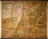
 MAP OF UNITED STATES BY P. A.
 EARLL, ATTICA, NY, CIRCA 1845 Attica, N.Y., circa 1845. Hand-drawn and colored map. Includes British Virgin Islands (lower right) with a vicinity of New York and Boston cartouche.
MAP OF UNITED STATES BY P. A.
MAP OF UNITED STATES BY P. A. EARLL, ATTICA, NY, CIRCA 1845 Attica, N.Y., circa 1845. Hand-drawn and colored map. Includes British Virgin Islands (lower right) with a vicinity of New York and Boston cartouche. -
 AN ANTIQUE MAP, "UNITED STATES OF
 NORTH AMERICA, SOUTHW...AN ANTIQUE MAP, "United States of North America, Southwest Sheet," 1893-1912, color engraving on paper, engraved, printed and published by W. & A.K. Johnston, Edinburgh and London, showing parts Baja California, Arizona, New Mexico, Texas, and Northern Mexico with lower detail views of Chicago, San Francisco, Philadelphia, and Boston, no. 52 from original atlas. 18 1/4" x 23 1/2" Provenance: Property from a Fortune 500 Energy Company, Houston, Texas. Condition: A crease at center as issued, mild toning and expected surface wear, but overall in good to very good condition, wear commensurate with age. Simpson Galleries strongly encourages in-person inspection of items by the bidder. Statements by Simpson Galleries regarding the condition of objects are for guidance only and should not be relied upon as statements of fact and do not constitute a representation, warranty, or assumption of liability by Simpson Galleries. All lots offered are sold "AS IS."
AN ANTIQUE MAP, "UNITED STATES OF
AN ANTIQUE MAP, "UNITED STATES OF NORTH AMERICA, SOUTHW...AN ANTIQUE MAP, "United States of North America, Southwest Sheet," 1893-1912, color engraving on paper, engraved, printed and published by W. & A.K. Johnston, Edinburgh and London, showing parts Baja California, Arizona, New Mexico, Texas, and Northern Mexico with lower detail views of Chicago, San Francisco, Philadelphia, and Boston, no. 52 from original atlas. 18 1/4" x 23 1/2" Provenance: Property from a Fortune 500 Energy Company, Houston, Texas. Condition: A crease at center as issued, mild toning and expected surface wear, but overall in good to very good condition, wear commensurate with age. Simpson Galleries strongly encourages in-person inspection of items by the bidder. Statements by Simpson Galleries regarding the condition of objects are for guidance only and should not be relied upon as statements of fact and do not constitute a representation, warranty, or assumption of liability by Simpson Galleries. All lots offered are sold "AS IS." -
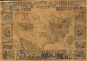
 1854 WALL MAP OF THE UNITED
 STATESca. mid 19th century; published by Ensign, Bridgman and Fanning and printed on canvas with various patriotic scenes around a central map of the U.S., 47" wide; Condition: as found, major areas of loss, especially at bottom and edges
1854 WALL MAP OF THE UNITED
1854 WALL MAP OF THE UNITED STATESca. mid 19th century; published by Ensign, Bridgman and Fanning and printed on canvas with various patriotic scenes around a central map of the U.S., 47" wide; Condition: as found, major areas of loss, especially at bottom and edges -
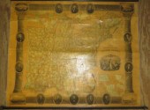
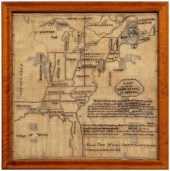 1825 map sampler, United States,
 territories and Eastern Canada outlined over an 11-line verse "When I view the chart of that world which God has produced from chaos let it teach me early that the pleasant scene will soon be dissolved so that my youthful soul may be abstracted from the world mount up to heaven rejoice in the divine approbation that the journey of life may be devoted to communion with my father and my God", stitched bottom proper left "Sarah Jane Warden Aged 10 years 6 months/compleated [sic] May 30 1825", "A map of the UNITED STATES of AMERICA" within cartouche, silk and wool on linen, American, possibly New York, circa 1825, 22-1/2 x 22-1/4 in. (sight); later wood frame. Scattered repairs, holes, losses to thread, fading. Joe Kindig, Jr. Antiques
1825 map sampler, United States,
1825 map sampler, United States, territories and Eastern Canada outlined over an 11-line verse "When I view the chart of that world which God has produced from chaos let it teach me early that the pleasant scene will soon be dissolved so that my youthful soul may be abstracted from the world mount up to heaven rejoice in the divine approbation that the journey of life may be devoted to communion with my father and my God", stitched bottom proper left "Sarah Jane Warden Aged 10 years 6 months/compleated [sic] May 30 1825", "A map of the UNITED STATES of AMERICA" within cartouche, silk and wool on linen, American, possibly New York, circa 1825, 22-1/2 x 22-1/4 in. (sight); later wood frame. Scattered repairs, holes, losses to thread, fading. Joe Kindig, Jr. Antiques -
 U.S. Civil War map, "Map of the
 United States of American showing the boundaries of the Union and Confederate Geographical Divisions and Departments, June 30, 1863", also marked "Atlas to accompany the official records of the Union and Confederate Armies", published by Julius Bien & Company, image 16-1/2 x 27-1/2 in., page 18-1/2 x 29-1/4 in.; faux burlwood frame with modern French mat. Slight browning. Couey Collection.
U.S. Civil War map, "Map of the
U.S. Civil War map, "Map of the United States of American showing the boundaries of the Union and Confederate Geographical Divisions and Departments, June 30, 1863", also marked "Atlas to accompany the official records of the Union and Confederate Armies", published by Julius Bien & Company, image 16-1/2 x 27-1/2 in., page 18-1/2 x 29-1/4 in.; faux burlwood frame with modern French mat. Slight browning. Couey Collection. -
 MITCHELL MAP OF THE UNITED STATES.
 Mitchell's Traveller's Guide Through the United States. A Map of the Roads Distances Steam Boat and Canal Routes &c. by J.B. Young. Philadelphia: S. Augustus Mitchell 1834. Engraving on wove paper with handcolored outlining. Minor imperfections. 17 1/2''h. 21 1/2''w. in a molded frame 19''h. 22 3/4''w. Even toning fold lines a few minor stains.
MITCHELL MAP OF THE UNITED STATES.
MITCHELL MAP OF THE UNITED STATES. Mitchell's Traveller's Guide Through the United States. A Map of the Roads Distances Steam Boat and Canal Routes &c. by J.B. Young. Philadelphia: S. Augustus Mitchell 1834. Engraving on wove paper with handcolored outlining. Minor imperfections. 17 1/2''h. 21 1/2''w. in a molded frame 19''h. 22 3/4''w. Even toning fold lines a few minor stains. -
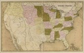
 A Large Collection of Maps of
 Various Regions of America, 19th/20th centuries, including the South Atlantic and the South Central States, the New England States, the Middle States, North and South Dakota, Nebraska, Kansas, Ohio and Indiana, etc., featuring a hand-colored map of the Middle States and part of the Southern by cartographer Samuel Augustus Mitchell, ca. 1839; also featuring maps of North America, Canada, the Pacific States, and maps of Illinois farms and residences, county maps that include a French geological graph, ca. 1837, by Thierry and a lithograph from the U.S. Pacific Railroad Expeditions & Surveys War Department of a geological section from the Mississippi River to the Pacific Ocean by William P. Blake, published by A. Hoen & Co., Baltimore, ca. 1853-54; together with a map of the rainfall in the United States and part of Canada, 1883, and a chart of the world showing the principal Industrial pursuits of the different countries, of varying sizes from 5" x 8" to 17" x 22".
A Large Collection of Maps of
A Large Collection of Maps of Various Regions of America, 19th/20th centuries, including the South Atlantic and the South Central States, the New England States, the Middle States, North and South Dakota, Nebraska, Kansas, Ohio and Indiana, etc., featuring a hand-colored map of the Middle States and part of the Southern by cartographer Samuel Augustus Mitchell, ca. 1839; also featuring maps of North America, Canada, the Pacific States, and maps of Illinois farms and residences, county maps that include a French geological graph, ca. 1837, by Thierry and a lithograph from the U.S. Pacific Railroad Expeditions & Surveys War Department of a geological section from the Mississippi River to the Pacific Ocean by William P. Blake, published by A. Hoen & Co., Baltimore, ca. 1853-54; together with a map of the rainfall in the United States and part of Canada, 1883, and a chart of the world showing the principal Industrial pursuits of the different countries, of varying sizes from 5" x 8" to 17" x 22". -
 JOHN ATWOOD PICTORIAL MAP OF THE
 UNITED STATES 1857 32" x 49" Issued by Ensign, Bridgman & Fanning, this map was drawn and engraved by J.M. Atwood and covers the entire United States from Atlantic to Pacific and from Canada to the Gulf of Mexico. Cartographically, the map illustrates an ephemeral period in the development of the American west. Issued in five different editions from 1847 to 1858, this map and the other four editions exhibit significant changes to the country.
JOHN ATWOOD PICTORIAL MAP OF THE
JOHN ATWOOD PICTORIAL MAP OF THE UNITED STATES 1857 32" x 49" Issued by Ensign, Bridgman & Fanning, this map was drawn and engraved by J.M. Atwood and covers the entire United States from Atlantic to Pacific and from Canada to the Gulf of Mexico. Cartographically, the map illustrates an ephemeral period in the development of the American west. Issued in five different editions from 1847 to 1858, this map and the other four editions exhibit significant changes to the country. -
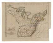
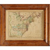
 MAP OF THE NORTHERN AND
 MID-ATLANTIC STATESMAP OF THE NORTHERN AND MID-ATLANTIC STATES, "A Map of the Northern and Middle States: Comprehending the Western Territory and the British Dominions in North America from the best Authorities", G. Allen Sadlers for Morse's Geography. Published by J. Stockdale, London, 1792. Provenance: Showing land grants of the Western Territory including Ohio, Tennessee and the Old Northwest Territory. The grants include Illinois Company, Army Lands, Wagbash Company, New Jersey Company, Ohio Company, and the 7 Ranges, along with the Donation Lands from the Commonwealth of Virginia and General Clark's Grant 1500 acres.
MAP OF THE NORTHERN AND
MAP OF THE NORTHERN AND MID-ATLANTIC STATESMAP OF THE NORTHERN AND MID-ATLANTIC STATES, "A Map of the Northern and Middle States: Comprehending the Western Territory and the British Dominions in North America from the best Authorities", G. Allen Sadlers for Morse's Geography. Published by J. Stockdale, London, 1792. Provenance: Showing land grants of the Western Territory including Ohio, Tennessee and the Old Northwest Territory. The grants include Illinois Company, Army Lands, Wagbash Company, New Jersey Company, Ohio Company, and the 7 Ranges, along with the Donation Lands from the Commonwealth of Virginia and General Clark's Grant 1500 acres. -
 AN ANTIQUE MAP, "UNITED STATES,"
 BOSTON, CIRCA 1838,AN ANTIQUE MAP, "United States," BOSTON, CIRCA 1838, hand colored engraving on paper, showing Texas as an independent nation, a page fragment from an atlas, Thomas Gamaliel Bradford (1802-1887) cartographer. 15" x 23 1/2" Note: The present map is a good example of early American state formation and attributed as a page fragment from An Illustrated Atlas Geographical, Statistical and Historical of the United States and Adjacent Countries published by T.G. Bradford in 1838. T.G. Bradford is among the first cartographers to record Texas as an independent nation. The Republic of Texas existed from 1836-1846. Provenance: Property from a Fortune 500 Energy Company, Houston, Texas. Condition: Some fading of hand coloring, some acid bleed of text, some foxing spots, apparent tears, mostly at crease, but overall in good to very good condition, wear commensurate with age and use. Simpson Galleries strongly encourages in-person inspection of items by the bidder. Statements by Simpson Galleries regarding the condition of objects are for guidance only and should not be relied upon as statements of fact and do not constitute a representation, warranty, or assumption of liability by Simpson Galleries. All lots offered are sold "AS IS."
AN ANTIQUE MAP, "UNITED STATES,"
AN ANTIQUE MAP, "UNITED STATES," BOSTON, CIRCA 1838,AN ANTIQUE MAP, "United States," BOSTON, CIRCA 1838, hand colored engraving on paper, showing Texas as an independent nation, a page fragment from an atlas, Thomas Gamaliel Bradford (1802-1887) cartographer. 15" x 23 1/2" Note: The present map is a good example of early American state formation and attributed as a page fragment from An Illustrated Atlas Geographical, Statistical and Historical of the United States and Adjacent Countries published by T.G. Bradford in 1838. T.G. Bradford is among the first cartographers to record Texas as an independent nation. The Republic of Texas existed from 1836-1846. Provenance: Property from a Fortune 500 Energy Company, Houston, Texas. Condition: Some fading of hand coloring, some acid bleed of text, some foxing spots, apparent tears, mostly at crease, but overall in good to very good condition, wear commensurate with age and use. Simpson Galleries strongly encourages in-person inspection of items by the bidder. Statements by Simpson Galleries regarding the condition of objects are for guidance only and should not be relied upon as statements of fact and do not constitute a representation, warranty, or assumption of liability by Simpson Galleries. All lots offered are sold "AS IS." -
 HAND-COLORED MAP OF THE UNITED
 STATES, 1791 ...with Part of the Adjoining Provinces, published by Robert Wilkinson, London, engraved by Thomas Conder, matted and framed under glass, 8.75"h x 11.25"w (sight), 13.5"h x 16"w (frame)
HAND-COLORED MAP OF THE UNITED
HAND-COLORED MAP OF THE UNITED STATES, 1791 ...with Part of the Adjoining Provinces, published by Robert Wilkinson, London, engraved by Thomas Conder, matted and framed under glass, 8.75"h x 11.25"w (sight), 13.5"h x 16"w (frame) -
 ABRAHAM BRADLEY JR. MAPAbraham
 Bradley Jr. map of the Northern Parts of the United States of America, ca. 1798 , from Jedidiah Morse's American Gazetteer , shows five proposed states including Ohio, with the northeast portion identified as "New Connecticut.", 8 3/4" x 15 3/4". Provenance: A Chester County, Pennsylvania collection. Competitive in-house shipping is available for this lot. Condition: Some splits at folds which have been backed, light stains, not examined out of frame.
ABRAHAM BRADLEY JR. MAPAbraham
ABRAHAM BRADLEY JR. MAPAbraham Bradley Jr. map of the Northern Parts of the United States of America, ca. 1798 , from Jedidiah Morse's American Gazetteer , shows five proposed states including Ohio, with the northeast portion identified as "New Connecticut.", 8 3/4" x 15 3/4". Provenance: A Chester County, Pennsylvania collection. Competitive in-house shipping is available for this lot. Condition: Some splits at folds which have been backed, light stains, not examined out of frame. -
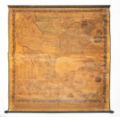
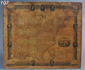
 ROLLED WALL CHART MAP OF UNITED
 STATES & WESTERN Pca. 1853; Chapin's steel plate engraved map on recanvased display published by Horace Thayer & Co., New York having a pillar and scroll embellished border with presidents and corner vignettes of Baltimore, Philadelphia, Boston & New York, 60"; Condition: older fabric remounted, some paper loss but overall good, some separation of paper from fabric, probably needs restoration again
ROLLED WALL CHART MAP OF UNITED
ROLLED WALL CHART MAP OF UNITED STATES & WESTERN Pca. 1853; Chapin's steel plate engraved map on recanvased display published by Horace Thayer & Co., New York having a pillar and scroll embellished border with presidents and corner vignettes of Baltimore, Philadelphia, Boston & New York, 60"; Condition: older fabric remounted, some paper loss but overall good, some separation of paper from fabric, probably needs restoration again -
 R. JUIGNE, GEOGRAPHICAL MAP OF
 AMERICA NO. XIIIContinuation of the United States or American Confederation, printed by R. Juigne, London, Circa early 19th Century. Very nicely hand colored engraving annotated with context and statistics printed in the surround. Overall framed size is 27" x 35". Excellent condition. shipping info This item will need to be shipped by a packing company of your choice. We maintain a list of reliable shippers, or you may choose your own.
R. JUIGNE, GEOGRAPHICAL MAP OF
R. JUIGNE, GEOGRAPHICAL MAP OF AMERICA NO. XIIIContinuation of the United States or American Confederation, printed by R. Juigne, London, Circa early 19th Century. Very nicely hand colored engraving annotated with context and statistics printed in the surround. Overall framed size is 27" x 35". Excellent condition. shipping info This item will need to be shipped by a packing company of your choice. We maintain a list of reliable shippers, or you may choose your own. -
 A rare map of the United States,
 made by Lewis Robinson of Reading, VT 1835. 42”H x 52”W Condition: estate as found, staining and repair to upper left edge, other edge repairs, some loss and a tear in upper middle, discoloration throughout CT Transfer Fee $20
A rare map of the United States,
A rare map of the United States, made by Lewis Robinson of Reading, VT 1835. 42”H x 52”W Condition: estate as found, staining and repair to upper left edge, other edge repairs, some loss and a tear in upper middle, discoloration throughout CT Transfer Fee $20 -
 Chapin's Ornamental Map of The
 United States 51 1/2'' x 60'' published 1841
Chapin's Ornamental Map of The
Chapin's Ornamental Map of The United States 51 1/2'' x 60'' published 1841 -
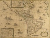
 * (MAP) LOTTER M. A. & G. F. A
 New and Correct Map of North America with the West India Islands ... According to the last Treaty of Peace Concluded at Paris the 20th of Jan. 1783. [London 1784]. Engraved map on four sheets joined hand-colored in outline. The map shows the area of the former British colonies the Eastern seaboard the Mississippi basin with New Mexico the Caribbean islands the South American coast and Central America with inset maps of Baffin and Hudson's Bay and part of California and an engraved cartouche depicting British merchants at port with a ship in the background being loaded with cargo by black slaves. Framed and matted. 51 x 56 inches.
* (MAP) LOTTER M. A. & G. F. A
* (MAP) LOTTER M. A. & G. F. A New and Correct Map of North America with the West India Islands ... According to the last Treaty of Peace Concluded at Paris the 20th of Jan. 1783. [London 1784]. Engraved map on four sheets joined hand-colored in outline. The map shows the area of the former British colonies the Eastern seaboard the Mississippi basin with New Mexico the Caribbean islands the South American coast and Central America with inset maps of Baffin and Hudson's Bay and part of California and an engraved cartouche depicting British merchants at port with a ship in the background being loaded with cargo by black slaves. Framed and matted. 51 x 56 inches. -
 'MAP OF NORTH AMERICA' C.1850,
 GEORGE VIRTUEFramed "Map of North America", c. 1850, published by G. Virtue (George Virtue (London, 1794-1868), showing Canada, the United States, Mexico and Central America hand color and outlines, embellished with depictions of Native Americans, Niagara Falls, White Bears (Polar) and others, hand color outlines, map approx. 13.25"h, 10"w, overall: 16"h, 13"w, 2.25lbs **Provenance: A prominent Dallas, Texas estate**
'MAP OF NORTH AMERICA' C.1850,
'MAP OF NORTH AMERICA' C.1850, GEORGE VIRTUEFramed "Map of North America", c. 1850, published by G. Virtue (George Virtue (London, 1794-1868), showing Canada, the United States, Mexico and Central America hand color and outlines, embellished with depictions of Native Americans, Niagara Falls, White Bears (Polar) and others, hand color outlines, map approx. 13.25"h, 10"w, overall: 16"h, 13"w, 2.25lbs **Provenance: A prominent Dallas, Texas estate** -
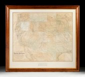 AN ANTIQUE MAP, "NATIONAL MAP OF
 THE TERRITORY OF THE U...AN ANTIQUE MAP, "National Map of the Territory of the United States from the Mississippi River to the Pacific Ocean," 1867, hand colored lithograph on paper, by J. Keeler, Civil Engineer, in collaboration with N. Du Bois, draughtsman, J.F. Gedney, Lithographer & Engraver, "Made by the authority of the Hon. O.H. Browning, Secretary of the Interior, in the Office of the Indian Bureau, Chiefly for Government purposes under the direction of the Hon. N.G. Taylor, commissioner of Indian Affairs and Hon. Chas. E. Mix, Chief Clerk of the Indian Bureau, compiled from authorized explorations of Pacific Railroad Routes, Public Surveys...Departments of Government at Washington D.C." 47" x 57" Provenance: Property from a Fortune 500 Energy Company, Houston, Texas. Condition: Apparent losses throughout, creasing, toning, fading of original color, hand colored dots notated throughout map, now preservation mounted, some toning, but overall in good condition, wear commensurate with age. Simpson Galleries strongly encourages in-person inspection of items by the bidder. Statements by Simpson Galleries regarding the condition of objects are for guidance only and should not be relied upon as statements of fact and do not constitute a representation, warranty, or assumption of liability by Simpson Galleries. All lots offered are sold "AS IS."
AN ANTIQUE MAP, "NATIONAL MAP OF
AN ANTIQUE MAP, "NATIONAL MAP OF THE TERRITORY OF THE U...AN ANTIQUE MAP, "National Map of the Territory of the United States from the Mississippi River to the Pacific Ocean," 1867, hand colored lithograph on paper, by J. Keeler, Civil Engineer, in collaboration with N. Du Bois, draughtsman, J.F. Gedney, Lithographer & Engraver, "Made by the authority of the Hon. O.H. Browning, Secretary of the Interior, in the Office of the Indian Bureau, Chiefly for Government purposes under the direction of the Hon. N.G. Taylor, commissioner of Indian Affairs and Hon. Chas. E. Mix, Chief Clerk of the Indian Bureau, compiled from authorized explorations of Pacific Railroad Routes, Public Surveys...Departments of Government at Washington D.C." 47" x 57" Provenance: Property from a Fortune 500 Energy Company, Houston, Texas. Condition: Apparent losses throughout, creasing, toning, fading of original color, hand colored dots notated throughout map, now preservation mounted, some toning, but overall in good condition, wear commensurate with age. Simpson Galleries strongly encourages in-person inspection of items by the bidder. Statements by Simpson Galleries regarding the condition of objects are for guidance only and should not be relied upon as statements of fact and do not constitute a representation, warranty, or assumption of liability by Simpson Galleries. All lots offered are sold "AS IS." -
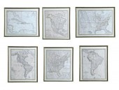 SIX SCARCE MAPS OF THE AMERICAS.
 Weimar Germany: C.F. Weiland. Handcolored engravings on paper. Includes the United States (1844) the eastern United States (1837) North America (1841) North and South America (1839) South America (1842) and the West Indies (1837). All approximately 18 1/2'' by 25'' in matching frames 22 1/2'' by 28 3/4''. All trimmed to the decorative borders the coloring has faded and there is some light toning.
SIX SCARCE MAPS OF THE AMERICAS.
SIX SCARCE MAPS OF THE AMERICAS. Weimar Germany: C.F. Weiland. Handcolored engravings on paper. Includes the United States (1844) the eastern United States (1837) North America (1841) North and South America (1839) South America (1842) and the West Indies (1837). All approximately 18 1/2'' by 25'' in matching frames 22 1/2'' by 28 3/4''. All trimmed to the decorative borders the coloring has faded and there is some light toning. -
 1631 HONDIO AMERICA NOVITER
 DELINEATA MAP: Features North & South America, coast of Europe and Africa, Atlantic and Pacific Oceans. This is a later state map, after the vignettes had been removed. Sight size 15'' x 20'', framed 22'' x 26 1/4''.CONDITION: Note fold line, traces of color, overall toning of paper. Map has been laid down
1631 HONDIO AMERICA NOVITER
1631 HONDIO AMERICA NOVITER DELINEATA MAP: Features North & South America, coast of Europe and Africa, Atlantic and Pacific Oceans. This is a later state map, after the vignettes had been removed. Sight size 15'' x 20'', framed 22'' x 26 1/4''.CONDITION: Note fold line, traces of color, overall toning of paper. Map has been laid down -
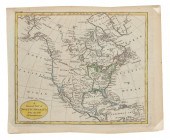
 18th century map of North
 America, "A General Map of North America Drawn from the Best Surveys", from American Atlas , published by John Reid, 1796, engraving on laid paper, page 16-1/2 x 19-3/8 in.; modern wood frame. Toning, minor foxing, tacked with glue to mat at upper margin, pencil inscriptions lower margin, scattered light pen marks, small tear lower left outside margin, crease down center with 3/4 in. separation at top and 1-1/2 in. separation at bottom; frame with abrasions.
18th century map of North
18th century map of North America, "A General Map of North America Drawn from the Best Surveys", from American Atlas , published by John Reid, 1796, engraving on laid paper, page 16-1/2 x 19-3/8 in.; modern wood frame. Toning, minor foxing, tacked with glue to mat at upper margin, pencil inscriptions lower margin, scattered light pen marks, small tear lower left outside margin, crease down center with 3/4 in. separation at top and 1-1/2 in. separation at bottom; frame with abrasions. -
 ROBERT DE VAUGONDY, MAP OF THE
 UNITED STATES, 1785Etats-Unis de L'Amerique Septentrionale map supplement to the atlas of Vaugondy, printed by Boudet, Paris, 1785. First reference to the existence of Michigan. Hand colored. Good condition and nicely framed with some wear including foxing and discolorations. Overall framed size is 30 1/2" x 36". shipping info This item will need to be shipped by a packing company of your choice. We maintain a list of reliable shippers, or you may choose your own.
ROBERT DE VAUGONDY, MAP OF THE
ROBERT DE VAUGONDY, MAP OF THE UNITED STATES, 1785Etats-Unis de L'Amerique Septentrionale map supplement to the atlas of Vaugondy, printed by Boudet, Paris, 1785. First reference to the existence of Michigan. Hand colored. Good condition and nicely framed with some wear including foxing and discolorations. Overall framed size is 30 1/2" x 36". shipping info This item will need to be shipped by a packing company of your choice. We maintain a list of reliable shippers, or you may choose your own. -
 Early map of the eastern United
 States Paris circa 1755 PARTIE DE L'AMERIQUE SEPTENTRIONALE QUI COMPREND LECOURS DE L'OHIO LA NLLE ANGLETERRE LA NLLE YORK LE NEW JERSEY LA PENSYLVANIE LE MARYLAND LA VIRGINIE LA CAROLINE by Didier Robert de Baugondy. Unframed with portions hand colored. H20'' W27 1/2'' Provenance: South Carolina private collection. Encapsulated between thin conservation paper; with losses mended tears and creases throughout. Back   Inquiry    Previous Item  Next Item © Charlton Hall Auctions. Images descriptions and condition reports used on this site are original copyright material and are not to be reproduced without permission. For further information telephone 803.779.5678   © 2012 CHARLTON HALL GALLERIES INC.
Early map of the eastern United
Early map of the eastern United States Paris circa 1755 PARTIE DE L'AMERIQUE SEPTENTRIONALE QUI COMPREND LECOURS DE L'OHIO LA NLLE ANGLETERRE LA NLLE YORK LE NEW JERSEY LA PENSYLVANIE LE MARYLAND LA VIRGINIE LA CAROLINE by Didier Robert de Baugondy. Unframed with portions hand colored. H20'' W27 1/2'' Provenance: South Carolina private collection. Encapsulated between thin conservation paper; with losses mended tears and creases throughout. Back   Inquiry    Previous Item  Next Item © Charlton Hall Auctions. Images descriptions and condition reports used on this site are original copyright material and are not to be reproduced without permission. For further information telephone 803.779.5678   © 2012 CHARLTON HALL GALLERIES INC. -
 John Cary, London, Hand-Colored
 Engraved Map of the United States, 1806, handsomely presented in a gilt-edged gold leaf and watercolor-banded pale blue French mat within a narrow giltwood frame in the neoclassical style and glazed, fully signed in the plate, sight h. 18-1/4", w. 20-3/4".
John Cary, London, Hand-Colored
John Cary, London, Hand-Colored Engraved Map of the United States, 1806, handsomely presented in a gilt-edged gold leaf and watercolor-banded pale blue French mat within a narrow giltwood frame in the neoclassical style and glazed, fully signed in the plate, sight h. 18-1/4", w. 20-3/4". -
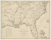 19th century map of the
 Southeast, "Southern Section of the United States including Florida & C.", based on 1816 map by John Melish, showing from the eastern seaboard into Missouri Territory, from Atlas til Friherre Klinckowstromo Bref om de Forente Staterne, by A.L. Klinckowstrom, Sweden, 1824, copper engraving on laid paper with watermarks, 17 x 20-1/2 in. (page). Loose, trimmed including some plate marks, toning, soiling, stains, creases, minor tears and losses at margins, pencil inscriptions lower left, cellophane tape verso.
19th century map of the
19th century map of the Southeast, "Southern Section of the United States including Florida & C.", based on 1816 map by John Melish, showing from the eastern seaboard into Missouri Territory, from Atlas til Friherre Klinckowstromo Bref om de Forente Staterne, by A.L. Klinckowstrom, Sweden, 1824, copper engraving on laid paper with watermarks, 17 x 20-1/2 in. (page). Loose, trimmed including some plate marks, toning, soiling, stains, creases, minor tears and losses at margins, pencil inscriptions lower left, cellophane tape verso. -
 "A GENERAL MAP OF NORTH AMERICA
 FROM THE BEST AUTHORITIES" 1794 ENGRAVING WITH HAND-COLORING, 8.5" X 10.25". UNFRAMED."A GENERAL MAP OF NORTH AMERICA FROM THE BEST AUTHORITIES", 1794, Engraved by Russell. From William Guthrie's Geography. The United States is named, as is Texas, Quivira, Taguayo, and New Albion., Dimensions: Engraving with hand-coloring, 8.5" x 10.25". Unframed.
"A GENERAL MAP OF NORTH AMERICA
"A GENERAL MAP OF NORTH AMERICA FROM THE BEST AUTHORITIES" 1794 ENGRAVING WITH HAND-COLORING, 8.5" X 10.25". UNFRAMED."A GENERAL MAP OF NORTH AMERICA FROM THE BEST AUTHORITIES", 1794, Engraved by Russell. From William Guthrie's Geography. The United States is named, as is Texas, Quivira, Taguayo, and New Albion., Dimensions: Engraving with hand-coloring, 8.5" x 10.25". Unframed.
...many more examples with full details are available to our members - Learn more
Easy & Visual methods to Identify & Appraise Antiques & Collectibles
EASY. FAST. ACCURATE.
Research at its best
We are here to help!
Our research tools include:

Thousands of makers marks for PORCELAIN, POTTERY CHINAWARE, FIGURINES, VASES
see details...

Thousands of marks & hallmarks for SILVER & JEWELRY, PEWTER, PRECIOUS METALS, SILVERPLATE
see details...
