Pricing Guides & Dictionary of Makers Marks for Antiques & Collectibles
A few examples of appraisal values for
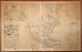
DISCOVERY OF AMERICA
Search our price guide for your own treasures
-
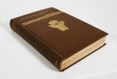
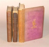 3 vols. Discovery & Exploration of
 America: Smith, Joshua Toulmin. The Discovery of America by The Northmen in The Tenth Century. London: Charles Tilt, 1839. 1st ed. 8vo, orig. brown cloth, gilt-lettered spine; some edge wear. With 2 fold. maps, plate, table. Scattered light foxing. Howes S-633. * Another copy of the preceding, orig. cloth, rebacked, 2 fold. maps (1 creased), plate, table. Occasional moderate foxing & toning. * Parkman, Francis. The Discovery of The Great West. London: J. Murray, 1869. 1st English ed. 8vo, orig. gilt-pictorial purple cloth; spine faded, some edge wear. Frontis. map. 32 pp. pub. cat., dated Sept. 1868 at back. Frontis. & title page sprung.
3 vols. Discovery & Exploration of
3 vols. Discovery & Exploration of America: Smith, Joshua Toulmin. The Discovery of America by The Northmen in The Tenth Century. London: Charles Tilt, 1839. 1st ed. 8vo, orig. brown cloth, gilt-lettered spine; some edge wear. With 2 fold. maps, plate, table. Scattered light foxing. Howes S-633. * Another copy of the preceding, orig. cloth, rebacked, 2 fold. maps (1 creased), plate, table. Occasional moderate foxing & toning. * Parkman, Francis. The Discovery of The Great West. London: J. Murray, 1869. 1st English ed. 8vo, orig. gilt-pictorial purple cloth; spine faded, some edge wear. Frontis. map. 32 pp. pub. cat., dated Sept. 1868 at back. Frontis. & title page sprung. -
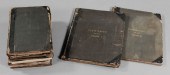
 (7) Antique Books Discovery of
 America1809 leather bound seven volumes by various authors who traveled to America during the 18th century one book featuring pull out maps and sketches of foreign nobleman and Chinese palaces.Volumes included are: 14 15 16 17 20 25 and 28.Overall good condition some warping to covers.
(7) Antique Books Discovery of
(7) Antique Books Discovery of America1809 leather bound seven volumes by various authors who traveled to America during the 18th century one book featuring pull out maps and sketches of foreign nobleman and Chinese palaces.Volumes included are: 14 15 16 17 20 25 and 28.Overall good condition some warping to covers. -
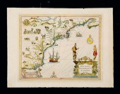
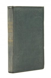 BEAMISH NORTH LUDLOW The
 Discovery of America by the Northmen in the Tenth Century with Notices of the Early Settlements of the Irish in the Western Hemisphere. London: T. and W. Boone 1841. 8vo blind-stamped green cloth title in gilt to spine. With 20 pp. publisher's advertisements at rear two fold-out maps and two fold-out plates. First edition. Inscribed ''With the author's compliments'' on the f.f.e.p. Wear and fading to boards; ends bumped; scattered light foxing.
BEAMISH NORTH LUDLOW The
BEAMISH NORTH LUDLOW The Discovery of America by the Northmen in the Tenth Century with Notices of the Early Settlements of the Irish in the Western Hemisphere. London: T. and W. Boone 1841. 8vo blind-stamped green cloth title in gilt to spine. With 20 pp. publisher's advertisements at rear two fold-out maps and two fold-out plates. First edition. Inscribed ''With the author's compliments'' on the f.f.e.p. Wear and fading to boards; ends bumped; scattered light foxing. -
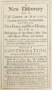 HENNEPIN "A NEW DISCOVERY OF A VAST
 COUNTRY IN AMERICA"...Father Louis Hennepin (1626 - 1704), "A New Discovery of a Vast Country in America, Extending above Four Thousand Miles, between New France and New Mexico, with a Description of the Great Lakes, Cataracts, Rivers, Plants, and Animals," London, 1698. Lacking original map but supplied with a facsimile. Condition: Please contact us for a detailed condition report. Please note that the lack of a condition statement does not imply perfect condition. Email condition@revereauctions.com with any condition questions.
HENNEPIN "A NEW DISCOVERY OF A VAST
HENNEPIN "A NEW DISCOVERY OF A VAST COUNTRY IN AMERICA"...Father Louis Hennepin (1626 - 1704), "A New Discovery of a Vast Country in America, Extending above Four Thousand Miles, between New France and New Mexico, with a Description of the Great Lakes, Cataracts, Rivers, Plants, and Animals," London, 1698. Lacking original map but supplied with a facsimile. Condition: Please contact us for a detailed condition report. Please note that the lack of a condition statement does not imply perfect condition. Email condition@revereauctions.com with any condition questions. -
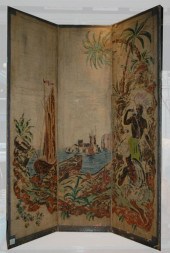 Polychrome Painted Canvas
 Three-Panel Screen Depicting the discovery of America. Estimate: $300 - $400
Polychrome Painted Canvas
Polychrome Painted Canvas Three-Panel Screen Depicting the discovery of America. Estimate: $300 - $400 -
 1895 PREHISTORIC AMERICA, GREAT
 ILLUSTRATIONS
1895 PREHISTORIC AMERICA, GREAT
1895 PREHISTORIC AMERICA, GREAT ILLUSTRATIONS -
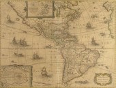
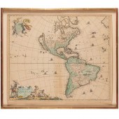 FREDERICK DE WIT, TOTIUS AMERICAE
 DESCRIPTIO, 1680 Frederick De Wit (Dutch, 1629-1706), "Novissima et Accuratissima totius Americae Descriptio", hand-colored map engraving of North and South America with California depicted as an island, decorated with images of Native Americans and indigenous flora and fauna, framed under glass, 19.5"h x 23"l (sheet), 22.5"h x 26"w (frame)
FREDERICK DE WIT, TOTIUS AMERICAE
FREDERICK DE WIT, TOTIUS AMERICAE DESCRIPTIO, 1680 Frederick De Wit (Dutch, 1629-1706), "Novissima et Accuratissima totius Americae Descriptio", hand-colored map engraving of North and South America with California depicted as an island, decorated with images of Native Americans and indigenous flora and fauna, framed under glass, 19.5"h x 23"l (sheet), 22.5"h x 26"w (frame) -
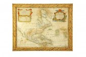
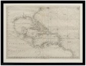
 COLLECTIBLE MAP: DISCOVERIES OF
 JAMES COOK'S THIRCOLLECTIBLE MAP: Discoveries of James Cook's Third Voyage titled "Chart of the NW Coast of America and NE Coast of Asia..." by Thomas Harman, published 1784. Opening measures 16.75" x 27.5". In a wood frame; 21.75" x 32" overall.
COLLECTIBLE MAP: DISCOVERIES OF
COLLECTIBLE MAP: DISCOVERIES OF JAMES COOK'S THIRCOLLECTIBLE MAP: Discoveries of James Cook's Third Voyage titled "Chart of the NW Coast of America and NE Coast of Asia..." by Thomas Harman, published 1784. Opening measures 16.75" x 27.5". In a wood frame; 21.75" x 32" overall. -
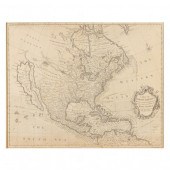 SEALE, ROBERT. A MAP OF NORTH
 AMERICA WITH THE EUROPEAN SETTLEMENTS... ...& whatever else is remarkable in ye West Indies from the latest and best Observations (London, circa 1745), a remarkably detailed map which includes the names and locations of many Indian tribes; California is still depicted as an island while the northwest's interior is honestly labeled "Parts Unknown"; presented behind mat in painted wooden frame (overall 25 x 21-1/2 in.).
SEALE, ROBERT. A MAP OF NORTH
SEALE, ROBERT. A MAP OF NORTH AMERICA WITH THE EUROPEAN SETTLEMENTS... ...& whatever else is remarkable in ye West Indies from the latest and best Observations (London, circa 1745), a remarkably detailed map which includes the names and locations of many Indian tribes; California is still depicted as an island while the northwest's interior is honestly labeled "Parts Unknown"; presented behind mat in painted wooden frame (overall 25 x 21-1/2 in.). -
 Herman Moll (Dutch/English
 1654-1732) "...Map of North America According to ye Newest and most Exact Observations..." c. 1719 London engraved copperplate map on two joined sheets in hand-colored outline showing California as an island large pictorial cartouche with American Indians and Eskimos ten inset maps showing harbors of New York Boston Havana etc. and a large vignette of "A View of a Stage & also of ye manner of Fishing for Curing & Drying Cod at New Foundland" 25 in. x 40 1/2 in.
Herman Moll (Dutch/English
Herman Moll (Dutch/English 1654-1732) "...Map of North America According to ye Newest and most Exact Observations..." c. 1719 London engraved copperplate map on two joined sheets in hand-colored outline showing California as an island large pictorial cartouche with American Indians and Eskimos ten inset maps showing harbors of New York Boston Havana etc. and a large vignette of "A View of a Stage & also of ye manner of Fishing for Curing & Drying Cod at New Foundland" 25 in. x 40 1/2 in. -
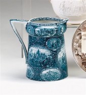 Green-blue transferware
 commemorative pitcher the rowland marsellus & co., staffordshire Of tapering form with bulbous neck, shaped handle inscribed "1492 Discovery of America," decorated with oval reserves depicting many firsts in American history, including William Penn's Treaty with the Indians, Landing of Columbus, Landing of Roger WilliamsDeSotots Discovery of the Mississippi, Daniel Boone's First View Of Kentucky, etc., within an oak leaf ground,. H: 7 1/4 in. good condition
Green-blue transferware
Green-blue transferware commemorative pitcher the rowland marsellus & co., staffordshire Of tapering form with bulbous neck, shaped handle inscribed "1492 Discovery of America," decorated with oval reserves depicting many firsts in American history, including William Penn's Treaty with the Indians, Landing of Columbus, Landing of Roger WilliamsDeSotots Discovery of the Mississippi, Daniel Boone's First View Of Kentucky, etc., within an oak leaf ground,. H: 7 1/4 in. good condition -
 KILLISTINS AND CHRISTINAUX (18TH
 CENTURY) A NEW MAP OF NORTH AMERICA FROM THE LATEST DISCOVERIES 1761 Engraving: 11 1/2 x 15 1/4 in. (sheet size) Framed
KILLISTINS AND CHRISTINAUX (18TH
KILLISTINS AND CHRISTINAUX (18TH CENTURY) A NEW MAP OF NORTH AMERICA FROM THE LATEST DISCOVERIES 1761 Engraving: 11 1/2 x 15 1/4 in. (sheet size) Framed -
 1631 HONDIO AMERICA NOVITER
 DELINEATA MAP: Features North & South America, coast of Europe and Africa, Atlantic and Pacific Oceans. This is a later state map, after the vignettes had been removed. Sight size 15'' x 20'', framed 22'' x 26 1/4''.CONDITION: Note fold line, traces of color, overall toning of paper. Map has been laid down
1631 HONDIO AMERICA NOVITER
1631 HONDIO AMERICA NOVITER DELINEATA MAP: Features North & South America, coast of Europe and Africa, Atlantic and Pacific Oceans. This is a later state map, after the vignettes had been removed. Sight size 15'' x 20'', framed 22'' x 26 1/4''.CONDITION: Note fold line, traces of color, overall toning of paper. Map has been laid down -
 EARLY MAP OF NORTH AMERICA.
 America Septentrionalis Augsburg: Guillaume de L'isle ca.1733. Engraving on laid paper with handcoloring. Imperfections. 19''h. 24 3/4''w. in a decorated frame 22 1/4''h. 28''w. Heavily toned moderately foxed and stained some scattered minor losses backed on coarsely woven fabric some of the color appears later.
EARLY MAP OF NORTH AMERICA.
EARLY MAP OF NORTH AMERICA. America Septentrionalis Augsburg: Guillaume de L'isle ca.1733. Engraving on laid paper with handcoloring. Imperfections. 19''h. 24 3/4''w. in a decorated frame 22 1/4''h. 28''w. Heavily toned moderately foxed and stained some scattered minor losses backed on coarsely woven fabric some of the color appears later. -
 18TH CENTURY HAND COLORED MAP OF
 THE AMERICAS,DATED 1746. TITLED "AMERICAE" OR "THE AMERICAS". INTERESTING DEPICTION OF NATIVES IN THE LOWER LEFT. SHOWS SOME CREASING AND FOLDING LINES. MINOR STAINING. NICE MODERN FRAME AND MATTING. SIGHT SIZE 19 1/2" X 22 1/4", OVERALL 25" X 30 1/2" .
18TH CENTURY HAND COLORED MAP OF
18TH CENTURY HAND COLORED MAP OF THE AMERICAS,DATED 1746. TITLED "AMERICAE" OR "THE AMERICAS". INTERESTING DEPICTION OF NATIVES IN THE LOWER LEFT. SHOWS SOME CREASING AND FOLDING LINES. MINOR STAINING. NICE MODERN FRAME AND MATTING. SIGHT SIZE 19 1/2" X 22 1/4", OVERALL 25" X 30 1/2" . -
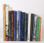 Twenty-three books and pamphlets
 mainly on history and art history, including Columbus and the Age of Discovery, Theodore Roosevelt: Icon of the American History, Williamsburg Before and After, and American Printmaking: The First 150 Years.
Twenty-three books and pamphlets
Twenty-three books and pamphlets mainly on history and art history, including Columbus and the Age of Discovery, Theodore Roosevelt: Icon of the American History, Williamsburg Before and After, and American Printmaking: The First 150 Years. -
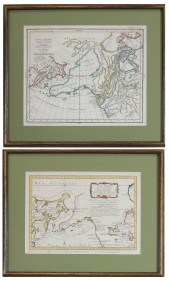 TWO COLLECTIBLE MAPS: DISCOVERIES
 OF RUSSIAN, ASITWO COLLECTIBLE MAPS: Discoveries of Russian, Asia, and North America by Jacques N. Bellin, titled "Carte Reduite Des Decouvertes Des Russes, Entre l'Asie et l'Amerique..." published in Paris, circa 1764, image measures 7.75" x 11.25"; Discoveries of the mythical de Fonte, showing the Northwest Passage, titled "Carte Generale des Decouvertes de l'Amiral de Fonte..." by Robert De Vaugondy, published Paris, circa 1772, image measures 11.5" x 14". Both engraved maps with hand-coloring. In wood frames.
TWO COLLECTIBLE MAPS: DISCOVERIES
TWO COLLECTIBLE MAPS: DISCOVERIES OF RUSSIAN, ASITWO COLLECTIBLE MAPS: Discoveries of Russian, Asia, and North America by Jacques N. Bellin, titled "Carte Reduite Des Decouvertes Des Russes, Entre l'Asie et l'Amerique..." published in Paris, circa 1764, image measures 7.75" x 11.25"; Discoveries of the mythical de Fonte, showing the Northwest Passage, titled "Carte Generale des Decouvertes de l'Amiral de Fonte..." by Robert De Vaugondy, published Paris, circa 1772, image measures 11.5" x 14". Both engraved maps with hand-coloring. In wood frames. -
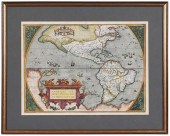
 Abraham Ortelius 16th Cent.
 ''Americae Siv Novi Orbis Nova Descriptio'' Map Engraving. Hand tinted Western Hemisphere map of America circa 1570-73, printed in Antwerp. Gallery framed with glass on both sides. Not inspected outside of the framing. 15''x20'' sight size, overall framed measurements of 21.5''x27''. Visibly in excellent condition with strong colors; some light toning.
Abraham Ortelius 16th Cent.
Abraham Ortelius 16th Cent. ''Americae Siv Novi Orbis Nova Descriptio'' Map Engraving. Hand tinted Western Hemisphere map of America circa 1570-73, printed in Antwerp. Gallery framed with glass on both sides. Not inspected outside of the framing. 15''x20'' sight size, overall framed measurements of 21.5''x27''. Visibly in excellent condition with strong colors; some light toning. -
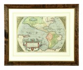
 A RENAISSANCE MAP, "AMERICæ SIVE
 NOVI ORBIS, NOVA DESCR...A RENAISSANCE MAP, "Americæ sive Novi Orbis, Nova Descriptio," ANTWERP, 1573-1587, a hand colored copperplate engraving on paper, a fragment from the atlas Theatrum Orbis Terrarum, compiled and published by cartographer Abraham Ortelius (Barbantian 1527-1598), showing North America, the northwest corner called Anian, refers to a "northern passage," below Apelchen, a body of water labeled Wingan and Dekoa, known today as Chesapeake Bay appears for the first time, the seas dotted with islands, Spanish and Portuguese ships, a distressed ship flys a maritime flag and a smaller boat provides help, the lower title cartouche with winged recumbent lions, fruiting quince saplings, and garlands heavy with melons, grapes, citrus, and squash, within dramatic masks, overlaid with latitudinal and longitudinal lines, within four grotesque mask and flowering scroll corners. Sheet: 18 5/8" x 23 3/8", Plate: 14" x 19 1/4" Provenance: Property from a Corporate Collection, Houston, Texas. Property from a Corporate Collection, Houston, Texas Condition: Some spots, minor losses, backed repairs, mild fading of color, overall in good to very good condition, wear commensurate with age. Simpson Galleries strongly encourages in-person inspection of items by the bidder. Statements by Simpson Galleries regarding the condition of objects are for guidance only and should not be relied upon as statements of fact and do not constitute a representation, warranty, or assumption of liability by Simpson Galleries. All lots offered are sold "AS IS.” NO REFUNDS will be issued based on condition.
A RENAISSANCE MAP, "AMERICæ SIVE
A RENAISSANCE MAP, "AMERICæ SIVE NOVI ORBIS, NOVA DESCR...A RENAISSANCE MAP, "Americæ sive Novi Orbis, Nova Descriptio," ANTWERP, 1573-1587, a hand colored copperplate engraving on paper, a fragment from the atlas Theatrum Orbis Terrarum, compiled and published by cartographer Abraham Ortelius (Barbantian 1527-1598), showing North America, the northwest corner called Anian, refers to a "northern passage," below Apelchen, a body of water labeled Wingan and Dekoa, known today as Chesapeake Bay appears for the first time, the seas dotted with islands, Spanish and Portuguese ships, a distressed ship flys a maritime flag and a smaller boat provides help, the lower title cartouche with winged recumbent lions, fruiting quince saplings, and garlands heavy with melons, grapes, citrus, and squash, within dramatic masks, overlaid with latitudinal and longitudinal lines, within four grotesque mask and flowering scroll corners. Sheet: 18 5/8" x 23 3/8", Plate: 14" x 19 1/4" Provenance: Property from a Corporate Collection, Houston, Texas. Property from a Corporate Collection, Houston, Texas Condition: Some spots, minor losses, backed repairs, mild fading of color, overall in good to very good condition, wear commensurate with age. Simpson Galleries strongly encourages in-person inspection of items by the bidder. Statements by Simpson Galleries regarding the condition of objects are for guidance only and should not be relied upon as statements of fact and do not constitute a representation, warranty, or assumption of liability by Simpson Galleries. All lots offered are sold "AS IS.” NO REFUNDS will be issued based on condition. -
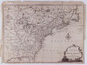
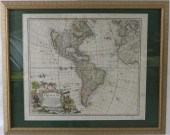
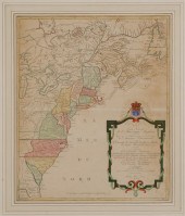 Map of Colonial America Carte
 Nouvelle de L'Amerique Angloise… by Matthieu Albert Lotter, Augsburg, circa 1776, from Lotter's Atlas Geographique, showing the Atlantic seaboard from Canada to Florida with the 13 original colonies filled in and outlined in hand color, on wove paper, 23-3/4 x 19-1/4 in. (sight), modern wood frame,
Map of Colonial America Carte
Map of Colonial America Carte Nouvelle de L'Amerique Angloise… by Matthieu Albert Lotter, Augsburg, circa 1776, from Lotter's Atlas Geographique, showing the Atlantic seaboard from Canada to Florida with the 13 original colonies filled in and outlined in hand color, on wove paper, 23-3/4 x 19-1/4 in. (sight), modern wood frame, -
 D'ANVILLE AND DE VAUGONDY, A NEW
 MAP OF NORTH AMERICA... ...with the British, French, Spanish, Dutch & Danish Dominions on that great Continent; and the West India Islands, According to the Definitive Treaty, concluded at Paris 10th February 1763. (London: Robert Sayer, n.d.), circa 1763, copperplate engraving with hand color, two insets below the cartouche variously show the political divisions of North America and maps of ten ports stretching from Nova Scotia to Cartagena. Presented in 20th century gilt wooden frame with brass title plate reading "Sayer 1763."
D'ANVILLE AND DE VAUGONDY, A NEW
D'ANVILLE AND DE VAUGONDY, A NEW MAP OF NORTH AMERICA... ...with the British, French, Spanish, Dutch & Danish Dominions on that great Continent; and the West India Islands, According to the Definitive Treaty, concluded at Paris 10th February 1763. (London: Robert Sayer, n.d.), circa 1763, copperplate engraving with hand color, two insets below the cartouche variously show the political divisions of North America and maps of ten ports stretching from Nova Scotia to Cartagena. Presented in 20th century gilt wooden frame with brass title plate reading "Sayer 1763." -
 Map of America after Joannis
 Janssonius Amsterdam circa 1630 NOVA ANGLIA NOVVM BELGIUM ET VIRGINIA (Nova Scotia to Virginia) colored engraving framed paper size: H18'' W24'' Back   Inquiry    Previous Item  Next Item © Charlton Hall Auctions. Images descriptions and condition reports used on this site are original copyright material and are not to be reproduced without permission. For further information telephone 803.779.5678   © 2012 CHARLTON HALL GALLERIES INC.
Map of America after Joannis
Map of America after Joannis Janssonius Amsterdam circa 1630 NOVA ANGLIA NOVVM BELGIUM ET VIRGINIA (Nova Scotia to Virginia) colored engraving framed paper size: H18'' W24'' Back   Inquiry    Previous Item  Next Item © Charlton Hall Auctions. Images descriptions and condition reports used on this site are original copyright material and are not to be reproduced without permission. For further information telephone 803.779.5678   © 2012 CHARLTON HALL GALLERIES INC. -
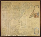 Emanuel Bowen and John Gibson "An
 Accurate Map of North America Describing and Distinquishing the British and Spanish Dominions According to The Definitive Treaty Concluded at Paris 10th Feby. 1763" published by Robert Sayer 1775 London fourth state four sheets joined as one copperplate engraving with original hand-coloring featuring a large decorative cartouche detailed information of towns Indian tribes forts villages roads trading paths portages mines mountains lakes and rivers an inset map shows Baffin & Hudson Bay another shows the famous Kino map which proved California not to be an island 42 in. x 47 1/2 in. framed.
Emanuel Bowen and John Gibson "An
Emanuel Bowen and John Gibson "An Accurate Map of North America Describing and Distinquishing the British and Spanish Dominions According to The Definitive Treaty Concluded at Paris 10th Feby. 1763" published by Robert Sayer 1775 London fourth state four sheets joined as one copperplate engraving with original hand-coloring featuring a large decorative cartouche detailed information of towns Indian tribes forts villages roads trading paths portages mines mountains lakes and rivers an inset map shows Baffin & Hudson Bay another shows the famous Kino map which proved California not to be an island 42 in. x 47 1/2 in. framed. -
 GIOVANNI BOTERO ENGRAVED MAP
 'AMERICA", CA. 1618 Giovanni Botero (Italian 1500-1566), 'America,' circa 1618, map depicting the Western Hemisphere, first state published 1598, this piece is a second state hand colored engraving by Girolamo Porro, with his name added in the lower left corner, in protective sleeve. Provenance: From the Estate of C.T. and William Biggers, Atlanta, Georgia. Approximate dimensions: paper h. 9.75", w. 10.5".
GIOVANNI BOTERO ENGRAVED MAP
GIOVANNI BOTERO ENGRAVED MAP 'AMERICA", CA. 1618 Giovanni Botero (Italian 1500-1566), 'America,' circa 1618, map depicting the Western Hemisphere, first state published 1598, this piece is a second state hand colored engraving by Girolamo Porro, with his name added in the lower left corner, in protective sleeve. Provenance: From the Estate of C.T. and William Biggers, Atlanta, Georgia. Approximate dimensions: paper h. 9.75", w. 10.5". -
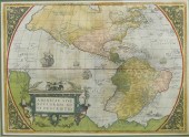
 EARLY MAP OF THE AMERICAS. Abraham
 Ortelius Americae sive Novi Orbis Nova Descriptio Antwerp dated 1587 (probably the 1595 impression). Handcolored engraving. Matted and framed 23.5''h. 28.5''w. Overall very good condition. Center seam at bottom of map has separated. Foxing at margins. Few watermarks at margins. Handcolored. * Probably early 20th century color. Top margin: 1'' Bottom margin: 1.5'' Left margin: .75'' Right margin: .75'' Text on reverse in Latin the introduction to the map of the Novus Orbis.
EARLY MAP OF THE AMERICAS. Abraham
EARLY MAP OF THE AMERICAS. Abraham Ortelius Americae sive Novi Orbis Nova Descriptio Antwerp dated 1587 (probably the 1595 impression). Handcolored engraving. Matted and framed 23.5''h. 28.5''w. Overall very good condition. Center seam at bottom of map has separated. Foxing at margins. Few watermarks at margins. Handcolored. * Probably early 20th century color. Top margin: 1'' Bottom margin: 1.5'' Left margin: .75'' Right margin: .75'' Text on reverse in Latin the introduction to the map of the Novus Orbis. -
 18th century map of the Americas,
 Plate 3 of "Ocean Atlantique et Mers Adjacentes en Quatre Feuilles…" by Robert Sayer, showing southeastern North America, the Gulf of Mexico, the Caribbean Islands, and northern South America, published in Pilote Americain by George Louis Le Rouge, France, 1778, copper engraving on laid paper with watermarks, page 21 x 28-1/2 in.; modern wood frame. Archival tape, earlier paper hinges still attached, toning, foxing, fading, soiling, stains, pest damage, reinforced center crease, tears and losses in margins, numerous fills and repaired tears, "56" in ink verso (probably period); frame with abrasions. Deaccessioned from MESDA and Old Salem to benefit the Acquisition Fund.
18th century map of the Americas,
18th century map of the Americas, Plate 3 of "Ocean Atlantique et Mers Adjacentes en Quatre Feuilles…" by Robert Sayer, showing southeastern North America, the Gulf of Mexico, the Caribbean Islands, and northern South America, published in Pilote Americain by George Louis Le Rouge, France, 1778, copper engraving on laid paper with watermarks, page 21 x 28-1/2 in.; modern wood frame. Archival tape, earlier paper hinges still attached, toning, foxing, fading, soiling, stains, pest damage, reinforced center crease, tears and losses in margins, numerous fills and repaired tears, "56" in ink verso (probably period); frame with abrasions. Deaccessioned from MESDA and Old Salem to benefit the Acquisition Fund. -
 19th Century United States
 Exploring Expedition Atlases United States Exploring Expedition. During the Years 1838, 1839, 1840, 1841, 1842, under the Command of Charles Wilkes, U.S.N. (American naval officer and explorer, 1798-1877), nine folio volumes of engraved plates to accompany the published scientific reports from the expedition, including works by noted scientists James D. Dana and Asa Gray, bound in green or black cloth, many engravings with bright hand color, 22 x 15 in. to 27 x 22 in.; detailed listing available,
19th Century United States
19th Century United States Exploring Expedition Atlases United States Exploring Expedition. During the Years 1838, 1839, 1840, 1841, 1842, under the Command of Charles Wilkes, U.S.N. (American naval officer and explorer, 1798-1877), nine folio volumes of engraved plates to accompany the published scientific reports from the expedition, including works by noted scientists James D. Dana and Asa Gray, bound in green or black cloth, many engravings with bright hand color, 22 x 15 in. to 27 x 22 in.; detailed listing available, -
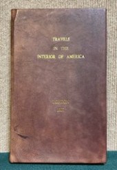 First British edition of the
 Presidential notice of discoveries made by Lewis and Clark, first presented in 1806 to the Senate and House of Representatives. Titled “Travels in the Interior Parts of America, Communicating Discoveries Made in Exploring the Missouri, Red River and Washita, by Captains Lewis and Clark, Doctor Sibley, and Mr. Dunbar; With a Statistical Account of the Countries Adjacent.” Printed for Richard Phillips, London, 1807. Condition: rebound in brown leather with Florentine paper end pages and gilt lettering, minor toning to edges of pages. CT Transfer Fee $10
First British edition of the
First British edition of the Presidential notice of discoveries made by Lewis and Clark, first presented in 1806 to the Senate and House of Representatives. Titled “Travels in the Interior Parts of America, Communicating Discoveries Made in Exploring the Missouri, Red River and Washita, by Captains Lewis and Clark, Doctor Sibley, and Mr. Dunbar; With a Statistical Account of the Countries Adjacent.” Printed for Richard Phillips, London, 1807. Condition: rebound in brown leather with Florentine paper end pages and gilt lettering, minor toning to edges of pages. CT Transfer Fee $10 -
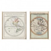 TWO SMALL EARLY MAPS SHOWING
 CALIFORNIA AS AN ISLAND Presented in the same frame, as follows: Mallet, Alain Manesson. Nouveau Continent ou Amerique (Paris, 1684); plus, Bodenahr, Gabriel. Der Neuen West Begrift...Nord America und Sud America (Augsburg, circa 1700); both maps being copperplate engravings with outline color and presented together behind a mat in a gilt wooden frame (12 x 17 in.).
TWO SMALL EARLY MAPS SHOWING
TWO SMALL EARLY MAPS SHOWING CALIFORNIA AS AN ISLAND Presented in the same frame, as follows: Mallet, Alain Manesson. Nouveau Continent ou Amerique (Paris, 1684); plus, Bodenahr, Gabriel. Der Neuen West Begrift...Nord America und Sud America (Augsburg, circa 1700); both maps being copperplate engravings with outline color and presented together behind a mat in a gilt wooden frame (12 x 17 in.). -
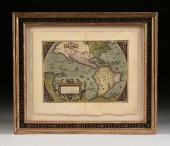
 ABRAHAM ORTELIUS - MAP OF THE
 AMERICASAbraham Ortelius (1527-1598), Americae Sive Novi Orbis Nova Descriptio , Antwerp, circa 1587, text in French verso, third edition (first state), engraving on laid paper with hand color, sheet 15-3/4 x 22-1/4 in.; gilt wood frame, 20-3/4 x 26 in. Condition: taped in on mat at upper and lower edge, light toning and scattered foxing at edges, reinforced along join line; frame with light wear and abrasions
ABRAHAM ORTELIUS - MAP OF THE
ABRAHAM ORTELIUS - MAP OF THE AMERICASAbraham Ortelius (1527-1598), Americae Sive Novi Orbis Nova Descriptio , Antwerp, circa 1587, text in French verso, third edition (first state), engraving on laid paper with hand color, sheet 15-3/4 x 22-1/4 in.; gilt wood frame, 20-3/4 x 26 in. Condition: taped in on mat at upper and lower edge, light toning and scattered foxing at edges, reinforced along join line; frame with light wear and abrasions -
 Pike's Travels Through America
 first English edition of Exploratory Travels through the Western Territories of North America: Comprising a Voyage from St. Louis, on the Mississippi, to the Source of that River, and a Journey through the Interior of Louisiana, and the North-eastern Provinces of New Spain, by Zebulon Montgomery Pike, printed for Longman, et al., London, 1811, with two maps (one folding), three-quarter morocco covers with raised bands and marbled boards, pages uncut, wove paper, 11-3/8 x 9-1/8 in.,
Pike's Travels Through America
Pike's Travels Through America first English edition of Exploratory Travels through the Western Territories of North America: Comprising a Voyage from St. Louis, on the Mississippi, to the Source of that River, and a Journey through the Interior of Louisiana, and the North-eastern Provinces of New Spain, by Zebulon Montgomery Pike, printed for Longman, et al., London, 1811, with two maps (one folding), three-quarter morocco covers with raised bands and marbled boards, pages uncut, wove paper, 11-3/8 x 9-1/8 in., -
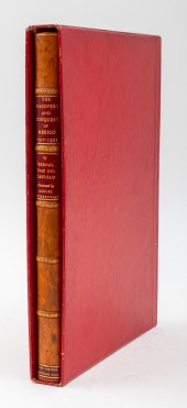 BERNAL DIAZ DEL CASTILLO'S
 "DISCOVERY..." 1942 Bernal Diaz Del Castillo (Spanish, d. 1584) leather-bound "The Discovery and Conquest of Mexico 1517-1521, edited by Genaro Garcia, translated by A.P. Maudslay, illustrated by Miguel Covarrubias, and printed in Mexica by Rafael Loera Y Chavez for the Limited Editions Club in 1942, together with original slipcase box. 13.25" H x 9.25" W x 1.5" D.
BERNAL DIAZ DEL CASTILLO'S
BERNAL DIAZ DEL CASTILLO'S "DISCOVERY..." 1942 Bernal Diaz Del Castillo (Spanish, d. 1584) leather-bound "The Discovery and Conquest of Mexico 1517-1521, edited by Genaro Garcia, translated by A.P. Maudslay, illustrated by Miguel Covarrubias, and printed in Mexica by Rafael Loera Y Chavez for the Limited Editions Club in 1942, together with original slipcase box. 13.25" H x 9.25" W x 1.5" D. -
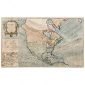
 18th century map, North America,
 Mexico, "A Map of Mexico or New Spain Florida now called Louisiana and Part of California & c." by Herman Moll, from Atlas Geographus: or; A Compleat System of Geography, (Ancient and Modern) For America , published by John Nicholson, circa 1720, hand colored copper engraving on laid paper, 8 x 9 in. (page); modern wood frame. Laid down on acidic card, toning, minor foxing, tape residue, creases, pencil inscription "1715" lower right. Private Collection, Cashiers, North Carolina
18th century map, North America,
18th century map, North America, Mexico, "A Map of Mexico or New Spain Florida now called Louisiana and Part of California & c." by Herman Moll, from Atlas Geographus: or; A Compleat System of Geography, (Ancient and Modern) For America , published by John Nicholson, circa 1720, hand colored copper engraving on laid paper, 8 x 9 in. (page); modern wood frame. Laid down on acidic card, toning, minor foxing, tape residue, creases, pencil inscription "1715" lower right. Private Collection, Cashiers, North Carolina -
 JEAN BELLERE - MAP OF THE AMERICAS,
 CA. 1554Jean Bellere (c. 1526-1595), Brevis Exactaq Totius Novi Orbis Eiusq Insularum Descriptio Recens A Ioan Belllro Edita , Antwerp, circa 1554, from Lopez de Gomara's La Historia de las Indias , based on the travels of Ayllon, Gomes and Fagundes, engraving on laid paper with hand coloring, sheet 6-7/8 x 5-3/4 in.; carved gilt wood frame, 12 x 10-3/4 in. Condition: apparently tacked down on mat, likely trimmed, not examined out of frame; frame with light wear
JEAN BELLERE - MAP OF THE AMERICAS,
JEAN BELLERE - MAP OF THE AMERICAS, CA. 1554Jean Bellere (c. 1526-1595), Brevis Exactaq Totius Novi Orbis Eiusq Insularum Descriptio Recens A Ioan Belllro Edita , Antwerp, circa 1554, from Lopez de Gomara's La Historia de las Indias , based on the travels of Ayllon, Gomes and Fagundes, engraving on laid paper with hand coloring, sheet 6-7/8 x 5-3/4 in.; carved gilt wood frame, 12 x 10-3/4 in. Condition: apparently tacked down on mat, likely trimmed, not examined out of frame; frame with light wear -
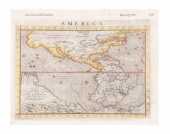
 AFTER JAMES WYLD SR, "MAP OF
 AMERICA", 1845 After James Wyld Sr. (British 1790-1836), "Map of America", 1845, colored copper engraving on paper, terrestrial map depicting North, Central, and South America, framed. Provenance: From the Estate of C.T. and William Biggers, Atlanta, Georgia. Approximate dimensions: Plate. h. 21", w. 23"; Sight 22", d. 24"; Overall h. 34.25", w. 35.75", d. 1.25"
AFTER JAMES WYLD SR, "MAP OF
AFTER JAMES WYLD SR, "MAP OF AMERICA", 1845 After James Wyld Sr. (British 1790-1836), "Map of America", 1845, colored copper engraving on paper, terrestrial map depicting North, Central, and South America, framed. Provenance: From the Estate of C.T. and William Biggers, Atlanta, Georgia. Approximate dimensions: Plate. h. 21", w. 23"; Sight 22", d. 24"; Overall h. 34.25", w. 35.75", d. 1.25" -
 DANCKERTS, JUSTUS. NOVA TOTIUS
 TERRARUM ORBIS (Amsterdam, circa 1680), copperplate engraving with hand color, depicts the two hemispheres and poles with a background given to lively allegorical scenes; California is depicted as an island, while northwestern North America is altogether unknown. Presented in painted and gilt wooden frame (overall 31-1/8 x 29 in.)
DANCKERTS, JUSTUS. NOVA TOTIUS
DANCKERTS, JUSTUS. NOVA TOTIUS TERRARUM ORBIS (Amsterdam, circa 1680), copperplate engraving with hand color, depicts the two hemispheres and poles with a background given to lively allegorical scenes; California is depicted as an island, while northwestern North America is altogether unknown. Presented in painted and gilt wooden frame (overall 31-1/8 x 29 in.)
...many more examples with full details are available to our members - Learn more
Easy & Visual methods to Identify & Appraise Antiques & Collectibles
EASY. FAST. ACCURATE.
Research at its best
We are here to help!
Our research tools include:

Thousands of makers marks for PORCELAIN, POTTERY CHINAWARE, FIGURINES, VASES
see details...

Thousands of marks & hallmarks for SILVER & JEWELRY, PEWTER, PRECIOUS METALS, SILVERPLATE
see details...
