Pricing Guides & Dictionary of Makers Marks for Antiques & Collectibles
A few examples of appraisal values for
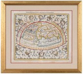
SEPTENTRIONALIS
Search our price guide for your own treasures
-
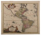
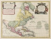
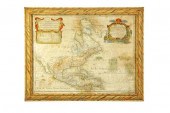
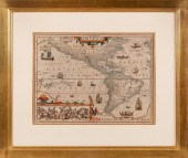
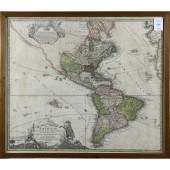
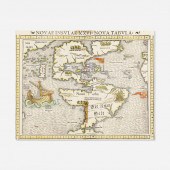
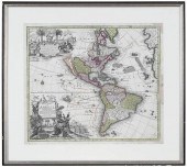 SEUTTER - MAP OF THE WESTERN
 HEMISPHEREMatthaus Seutter, Novus Orbis Sive America Meridionalis et Septentrionalis... , Augsburg, circa 1730, engraving on laid paper with hand colored highlights, sheet 21-1/4 x 24 in.; wood frame, 27-3/4 x 30-3/4 in. Provenance: W. Graham Arader III Gallery (label verso); Private Collection, Philadelphia Area Condition: hinged in on mat, scattered areas of staining throughout and some toning at margins, restorations to top right corner and right edge, some tears with reinforcements verso, small tears and creasing at edges; frame with light wear and abrasions
SEUTTER - MAP OF THE WESTERN
SEUTTER - MAP OF THE WESTERN HEMISPHEREMatthaus Seutter, Novus Orbis Sive America Meridionalis et Septentrionalis... , Augsburg, circa 1730, engraving on laid paper with hand colored highlights, sheet 21-1/4 x 24 in.; wood frame, 27-3/4 x 30-3/4 in. Provenance: W. Graham Arader III Gallery (label verso); Private Collection, Philadelphia Area Condition: hinged in on mat, scattered areas of staining throughout and some toning at margins, restorations to top right corner and right edge, some tears with reinforcements verso, small tears and creasing at edges; frame with light wear and abrasions -
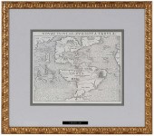
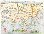
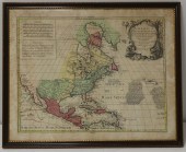 EARLY MAP AMERICA SEPTENTRIONALIS
 BY LOTTER Hand colored map, "America Septentrionalis", "Lotter" after De L'Isle, hand colored, foxing. From a Pound Ridge, NY estate. Dimensions: Sight: 20.5" h x 25.5" w. Condition: With foxing.
EARLY MAP AMERICA SEPTENTRIONALIS
EARLY MAP AMERICA SEPTENTRIONALIS BY LOTTER Hand colored map, "America Septentrionalis", "Lotter" after De L'Isle, hand colored, foxing. From a Pound Ridge, NY estate. Dimensions: Sight: 20.5" h x 25.5" w. Condition: With foxing. -
 AN ANTIQUE MAP, "AMERICA
 SEPTENTRIONALIS," NUREMBERG, 1...AN ANTIQUE MAP, "America Septentrionalis," NUREMBERG, 1756, hand color engraving on paper, Homann Heirs under direction of Johann Christoph (1703-1730), publishers, a mossy grotto form title cartouche reads, "a Domino d'Anville in Galliis edita nunc in Anglia, Coloniis in interiorem Virginiam deductis nec non fluvii ohio cursi acta notis geographicis et historias illustrata sumptibus homannionarum heredum, Noriberge, a. 1756," a lower paragraph gives a brief history in German about the English discovery and establishment of colonies from approximately 1497-1729, listing major native indigenous nations, while an upper paragraph details interventions and occupations of the French in the new world, showing the territories colored in yellow, red and green by Spanish, English and French occupation, overlaid with longitudinal and latitudinal lines and with one compass rose, plate: 18 3/4" x 20 3/4". Condition: Some handling creases, tears at joined center(as issued), but overall in good to very good condition, wear commensurate with age. Simpson Galleries strongly encourages in-person inspection of items by the bidder. Statements by Simpson Galleries regarding the condition of objects are for guidance only and should not be relied upon as statements of fact and do not constitute a representation, warranty, or assumption of liability by Simpson Galleries. All lots offered are sold "AS IS."
AN ANTIQUE MAP, "AMERICA
AN ANTIQUE MAP, "AMERICA SEPTENTRIONALIS," NUREMBERG, 1...AN ANTIQUE MAP, "America Septentrionalis," NUREMBERG, 1756, hand color engraving on paper, Homann Heirs under direction of Johann Christoph (1703-1730), publishers, a mossy grotto form title cartouche reads, "a Domino d'Anville in Galliis edita nunc in Anglia, Coloniis in interiorem Virginiam deductis nec non fluvii ohio cursi acta notis geographicis et historias illustrata sumptibus homannionarum heredum, Noriberge, a. 1756," a lower paragraph gives a brief history in German about the English discovery and establishment of colonies from approximately 1497-1729, listing major native indigenous nations, while an upper paragraph details interventions and occupations of the French in the new world, showing the territories colored in yellow, red and green by Spanish, English and French occupation, overlaid with longitudinal and latitudinal lines and with one compass rose, plate: 18 3/4" x 20 3/4". Condition: Some handling creases, tears at joined center(as issued), but overall in good to very good condition, wear commensurate with age. Simpson Galleries strongly encourages in-person inspection of items by the bidder. Statements by Simpson Galleries regarding the condition of objects are for guidance only and should not be relied upon as statements of fact and do not constitute a representation, warranty, or assumption of liability by Simpson Galleries. All lots offered are sold "AS IS." -
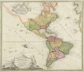
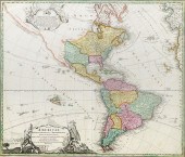
 HOMANN - TOTIUS AMERICAE
 SEPTENTRIONALIS ET..., MAPJohann Baptist Homann (1663-1724), Totius Americae Septentrionalis et Meridionalis Novissima Representatio... , Nuremberg, circa 1720, second state, in two sheets, engraving on laid paper with hand colored highlights, plate 19-3/8 x 22-7/8 in., sheet 21-1/4 x 24-1/2 in., unframed Provenance: Humber Family, North Carolina Condition: scattered light staining, formerly hinged in (tape remnants at top verso)
HOMANN - TOTIUS AMERICAE
HOMANN - TOTIUS AMERICAE SEPTENTRIONALIS ET..., MAPJohann Baptist Homann (1663-1724), Totius Americae Septentrionalis et Meridionalis Novissima Representatio... , Nuremberg, circa 1720, second state, in two sheets, engraving on laid paper with hand colored highlights, plate 19-3/8 x 22-7/8 in., sheet 21-1/4 x 24-1/2 in., unframed Provenance: Humber Family, North Carolina Condition: scattered light staining, formerly hinged in (tape remnants at top verso) -
 AN ANTIQUE MAP, "AMERICA
 SEPTENTRIONALIS," AUGSBURG, 17...AN ANTIQUE MAP, "America Septentrionalis," AUGSBURG, 1790, hand colored engraving on paper, after Tobias Conrad Lotter (1717-1777), showing the North American Hemisphere, including early 16th and 17th century routes in the Pacific Ocean, and a title cartouche with figures of Oceanus and Potamoi, plate: 18 1/4" x 24 1/4". Condition: Hand numbering in upper left margin, some faint pencil inscriptions also in margins, some staining mostly at edges, minor losses, expected creases and wear, but overall in very good condition, wear commensurate with age and use. Simpson Galleries strongly encourages in-person inspection of items by the bidder. Statements by Simpson Galleries regarding the condition of objects are for guidance only and should not be relied upon as statements of fact and do not constitute a representation, warranty, or assumption of liability by Simpson Galleries. All lots offered are sold "AS IS."
AN ANTIQUE MAP, "AMERICA
AN ANTIQUE MAP, "AMERICA SEPTENTRIONALIS," AUGSBURG, 17...AN ANTIQUE MAP, "America Septentrionalis," AUGSBURG, 1790, hand colored engraving on paper, after Tobias Conrad Lotter (1717-1777), showing the North American Hemisphere, including early 16th and 17th century routes in the Pacific Ocean, and a title cartouche with figures of Oceanus and Potamoi, plate: 18 1/4" x 24 1/4". Condition: Hand numbering in upper left margin, some faint pencil inscriptions also in margins, some staining mostly at edges, minor losses, expected creases and wear, but overall in very good condition, wear commensurate with age and use. Simpson Galleries strongly encourages in-person inspection of items by the bidder. Statements by Simpson Galleries regarding the condition of objects are for guidance only and should not be relied upon as statements of fact and do not constitute a representation, warranty, or assumption of liability by Simpson Galleries. All lots offered are sold "AS IS." -
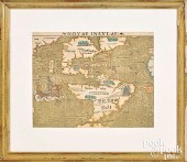
 (MAP) SEUTTER MATTHAEUS A group
 of two hand-colored engraved maps. Augsburg: [c. 1740 or later.] America Meridionalis per sua Renga Province. Hand-colored engraved map of South America. Nova Orbis sive America Septentrionis. Hand-colored engraved map of North America. Size of each 8 x 10 1/4 inches.
(MAP) SEUTTER MATTHAEUS A group
(MAP) SEUTTER MATTHAEUS A group of two hand-colored engraved maps. Augsburg: [c. 1740 or later.] America Meridionalis per sua Renga Province. Hand-colored engraved map of South America. Nova Orbis sive America Septentrionis. Hand-colored engraved map of North America. Size of each 8 x 10 1/4 inches. -
 BLAEU - INSULAE AMERICANAE IN
 OCEANO SEPTENTRIONALI, MA...Willem Janszoon Blaeu (1571-1638), Insulae Americanae in Oceano Septentrionali cum Terris adiacentibus , circa 1640-1660, in two sheets, text in French verso, engraving on laid paper with hand colored highlights, with decorative title cartouches, sailing ships, and compass rose, plate 15-1/4 x 20-3/4 in., sheet 16-1/2 x 21-7/8 in., unframed Provenance: Humber Family, North Carolina Condition: scattered light staining, formerly hinged in (tape remnants at top verso)
BLAEU - INSULAE AMERICANAE IN
BLAEU - INSULAE AMERICANAE IN OCEANO SEPTENTRIONALI, MA...Willem Janszoon Blaeu (1571-1638), Insulae Americanae in Oceano Septentrionali cum Terris adiacentibus , circa 1640-1660, in two sheets, text in French verso, engraving on laid paper with hand colored highlights, with decorative title cartouches, sailing ships, and compass rose, plate 15-1/4 x 20-3/4 in., sheet 16-1/2 x 21-7/8 in., unframed Provenance: Humber Family, North Carolina Condition: scattered light staining, formerly hinged in (tape remnants at top verso) -
 AN ANTIQUE MAP, "TOTIUS AMERICAE
 SEPTENTRIONALIS ET MER...AN ANTIQUE MAP, "Totius Americae Septentrionalis et Meridionalis," NUREMBERG, EARLY 18TH CENTURY, hand colored engraving on paper, published by Johann Baptist Homann (1664-1724), the figural title cartouche showing a North American Indian with Dutch windmills and settled farmland at his back and at left a South American Indian, and at center a scene of Trade between Indigenous and Explorers, duly noted are the personal weapons of war, and two types of armadillos. 20" x 23" Note: Johann Baptist Homann (March 20, 1664 - July 1, 1724) was the most prominent and prolific map publisher of the 18th century. Homann was born in Oberkammlach, a small town near Kammlach, Bavaria, Germany. As a young man Homann studied in a Jesuit school and nursed ambitions of becoming a Dominican priest before converting to Protestantism in 1687. Following his conversion, Homann moved to Nuremberg and found employment as a notary. Around 1693 Homan briefly relocated to Vienna, where he lived and studied printing and copper plate engraving until 1695. Afterwards he returned to Nuremberg where, in 1702, he founded the commercial publishing firm that would bear his name. In the next five years Homann produced hundreds of maps and developed a distinctive style characterized by heavy detailed engraving, elaborate allegorical cartouche work, and vivid hand color. The Homann firm, due to the lower cost of printing in Germany, was able to undercut the dominant French and Dutch publishing houses while matching the diversity and quality of their output. By 1715 Homann's rising star caught the attention of the Holy Roman Emperor Charles the VI, who appointed him Imperial Cartographer. In the same year he was also appointed a member of the Royal Academy of Sciences in Berlin. Homann's prestigious title came with a number of important advantages including access to the most up to date cartographic information as well as the "Privilege." The Privilege was a type of early copyright offered to a few individuals by the Holy Roman Emperor. Though not as sophisticated as modern copyright legislation, the Privilege did offer a kind of limited protection for several years. Most all J. B. Homann maps printed between 1715 and 1730 bear the inscription "Cum Priviligio" or some variation. Following Homann's death in 1726, the management of the firm passed to his son Johann Christoph Homann. The present map shows settlements, physical features, political divisions in North and South America and the West Indies; a portion of the coasts of Europe and Africa; islands in the Atlantic and Pacific Oceans, and settlements. Includes notes, dates of discovery, and illustrations. Condition: Mild expected wear, but overall in very good condition, wear commensurate with age. Simpson Galleries strongly encourages in-person inspection of items by the bidder. Statements by Simpson Galleries regarding the condition of objects are for guidance only and should not be relied upon as statements of fact and do not constitute a representation, warranty, or assumption of liability by Simpson Galleries. All lots offered are sold "AS IS."
AN ANTIQUE MAP, "TOTIUS AMERICAE
AN ANTIQUE MAP, "TOTIUS AMERICAE SEPTENTRIONALIS ET MER...AN ANTIQUE MAP, "Totius Americae Septentrionalis et Meridionalis," NUREMBERG, EARLY 18TH CENTURY, hand colored engraving on paper, published by Johann Baptist Homann (1664-1724), the figural title cartouche showing a North American Indian with Dutch windmills and settled farmland at his back and at left a South American Indian, and at center a scene of Trade between Indigenous and Explorers, duly noted are the personal weapons of war, and two types of armadillos. 20" x 23" Note: Johann Baptist Homann (March 20, 1664 - July 1, 1724) was the most prominent and prolific map publisher of the 18th century. Homann was born in Oberkammlach, a small town near Kammlach, Bavaria, Germany. As a young man Homann studied in a Jesuit school and nursed ambitions of becoming a Dominican priest before converting to Protestantism in 1687. Following his conversion, Homann moved to Nuremberg and found employment as a notary. Around 1693 Homan briefly relocated to Vienna, where he lived and studied printing and copper plate engraving until 1695. Afterwards he returned to Nuremberg where, in 1702, he founded the commercial publishing firm that would bear his name. In the next five years Homann produced hundreds of maps and developed a distinctive style characterized by heavy detailed engraving, elaborate allegorical cartouche work, and vivid hand color. The Homann firm, due to the lower cost of printing in Germany, was able to undercut the dominant French and Dutch publishing houses while matching the diversity and quality of their output. By 1715 Homann's rising star caught the attention of the Holy Roman Emperor Charles the VI, who appointed him Imperial Cartographer. In the same year he was also appointed a member of the Royal Academy of Sciences in Berlin. Homann's prestigious title came with a number of important advantages including access to the most up to date cartographic information as well as the "Privilege." The Privilege was a type of early copyright offered to a few individuals by the Holy Roman Emperor. Though not as sophisticated as modern copyright legislation, the Privilege did offer a kind of limited protection for several years. Most all J. B. Homann maps printed between 1715 and 1730 bear the inscription "Cum Priviligio" or some variation. Following Homann's death in 1726, the management of the firm passed to his son Johann Christoph Homann. The present map shows settlements, physical features, political divisions in North and South America and the West Indies; a portion of the coasts of Europe and Africa; islands in the Atlantic and Pacific Oceans, and settlements. Includes notes, dates of discovery, and illustrations. Condition: Mild expected wear, but overall in very good condition, wear commensurate with age. Simpson Galleries strongly encourages in-person inspection of items by the bidder. Statements by Simpson Galleries regarding the condition of objects are for guidance only and should not be relied upon as statements of fact and do not constitute a representation, warranty, or assumption of liability by Simpson Galleries. All lots offered are sold "AS IS." -
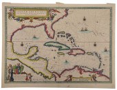
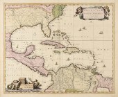
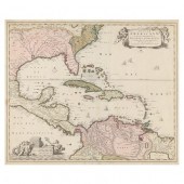 NICHOLAS VISSCHER, INSULAE
 AMERICANAE IN OCEANO SEPTENTRIONALI... ...ac Regiones Adjacentes, late 17th century, copperplate engraving with hand color, depicting the Caribbean and adjacent lands in North, South, and Central America; presented behind glass in mat within black wooden frame having a gilt liner.
NICHOLAS VISSCHER, INSULAE
NICHOLAS VISSCHER, INSULAE AMERICANAE IN OCEANO SEPTENTRIONALI... ...ac Regiones Adjacentes, late 17th century, copperplate engraving with hand color, depicting the Caribbean and adjacent lands in North, South, and Central America; presented behind glass in mat within black wooden frame having a gilt liner. -
 1 piece. Hand-Colored Engraved
 Map. Mercator, Gerard. "Septentrionaliuim Descriptio." (Amsterdam), [1634]. 14 1/2 x 15 1/2 inches (370 x 393 mm), margins. Moderate toning, skillful old color. Dutch text on verso. Framed. The first map to be devoted specifically to The Arctic. Burden 88 ,500-2,500 Descriptions provided in both printed and on-line catalogue formats do not include condition reports. The absence of a condition statement does not imply that the lot is in perfect condition or completely free from wear and tear, imperfections or the effects of aging. Interested bidders are strongly encouraged to request a condition report on any lots upon which they intend to bid, prior to placing a bid. All transactions are governed by Freeman''s Conditions of Sale.
1 piece. Hand-Colored Engraved
1 piece. Hand-Colored Engraved Map. Mercator, Gerard. "Septentrionaliuim Descriptio." (Amsterdam), [1634]. 14 1/2 x 15 1/2 inches (370 x 393 mm), margins. Moderate toning, skillful old color. Dutch text on verso. Framed. The first map to be devoted specifically to The Arctic. Burden 88 ,500-2,500 Descriptions provided in both printed and on-line catalogue formats do not include condition reports. The absence of a condition statement does not imply that the lot is in perfect condition or completely free from wear and tear, imperfections or the effects of aging. Interested bidders are strongly encouraged to request a condition report on any lots upon which they intend to bid, prior to placing a bid. All transactions are governed by Freeman''s Conditions of Sale. -
 HOMANN, Johann Baptiste, (German,
 1664-1724): Circa 1720, ''Totius Americae Septentrionalis et Meridionalis'', map representing North and South America with cartouches lower and upper left, traces of Africa and Europe for right. Hand colored. Sight size approx. 19.25'' h x 22.25'' w. Famed approx. 26.25'' h x 29.25'' w. CONDITION: Creased in center, scattered foxing commensurate with age and use.
HOMANN, Johann Baptiste, (German,
HOMANN, Johann Baptiste, (German, 1664-1724): Circa 1720, ''Totius Americae Septentrionalis et Meridionalis'', map representing North and South America with cartouches lower and upper left, traces of Africa and Europe for right. Hand colored. Sight size approx. 19.25'' h x 22.25'' w. Famed approx. 26.25'' h x 29.25'' w. CONDITION: Creased in center, scattered foxing commensurate with age and use. -
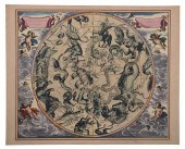 CELLARIUS - HAEMISPHAERIUM
 STELLATUM AUSTRALE..., MAPAndreas Cellarius (circa 1596?1665), Haemisphaerium Stellatum Australe Antiquum , Amsterdam, circa 1660, from Harmonia Macrocosmica , in two sheets, engraving on laid paper with elaborately colored and gilt highlights, map illustrating the constellations of the Southern hemisphere, plate 17-3/8 x 20-1/2 in., sheet 18-1/2 x 22-7/8 in. Provenance: Humber Family, North Carolina Condition: some very light toning and staining to edges
CELLARIUS - HAEMISPHAERIUM
CELLARIUS - HAEMISPHAERIUM STELLATUM AUSTRALE..., MAPAndreas Cellarius (circa 1596?1665), Haemisphaerium Stellatum Australe Antiquum , Amsterdam, circa 1660, from Harmonia Macrocosmica , in two sheets, engraving on laid paper with elaborately colored and gilt highlights, map illustrating the constellations of the Southern hemisphere, plate 17-3/8 x 20-1/2 in., sheet 18-1/2 x 22-7/8 in. Provenance: Humber Family, North Carolina Condition: some very light toning and staining to edges -
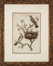 JAN CHRISTIAEN SEPP (DUTCH,
 1739-1811)Jan Christiaen Sepp (Dutch, 1739-1811) , "Lanius, Excubitor", "Motacilla, Flava", "Caprimulgus" and "Lanius Collyrio", 4 hand-colored engravings, unsigned, from Nederlandsche Volgelen, sights 17 in. x 11 3/4 in., framed alike. (4 pcs.)
JAN CHRISTIAEN SEPP (DUTCH,
JAN CHRISTIAEN SEPP (DUTCH, 1739-1811)Jan Christiaen Sepp (Dutch, 1739-1811) , "Lanius, Excubitor", "Motacilla, Flava", "Caprimulgus" and "Lanius Collyrio", 4 hand-colored engravings, unsigned, from Nederlandsche Volgelen, sights 17 in. x 11 3/4 in., framed alike. (4 pcs.) -
 EARLY MAP OF NORTH AMERICA.
 America Septentrionalis Augsburg: Guillaume de L'isle ca.1733. Engraving on laid paper with handcoloring. Imperfections. 19''h. 24 3/4''w. in a decorated frame 22 1/4''h. 28''w. Heavily toned moderately foxed and stained some scattered minor losses backed on coarsely woven fabric some of the color appears later.
EARLY MAP OF NORTH AMERICA.
EARLY MAP OF NORTH AMERICA. America Septentrionalis Augsburg: Guillaume de L'isle ca.1733. Engraving on laid paper with handcoloring. Imperfections. 19''h. 24 3/4''w. in a decorated frame 22 1/4''h. 28''w. Heavily toned moderately foxed and stained some scattered minor losses backed on coarsely woven fabric some of the color appears later. -
 SEBASTIAN MüNSTER - MAP OF THE
 AMERICAS, 1540Sebastian Münster (1488-1552), Novae Insulae XVII Nova Tabula , Basel, 1540, text in Latin verso, first state, from Münster's Geographia , engraving on laid paper, sheet 11-3/4 x 14-3/8 in.; carved and gilt wood frame, 20-1/2 x 23-1/4 in. Condition: hinged in on mat with archival tape at top edge, some staining at edges and along join line (especially verso), repair along join line, probably trimmed at top and right edges; frame with light wear
SEBASTIAN MüNSTER - MAP OF THE
SEBASTIAN MüNSTER - MAP OF THE AMERICAS, 1540Sebastian Münster (1488-1552), Novae Insulae XVII Nova Tabula , Basel, 1540, text in Latin verso, first state, from Münster's Geographia , engraving on laid paper, sheet 11-3/4 x 14-3/8 in.; carved and gilt wood frame, 20-1/2 x 23-1/4 in. Condition: hinged in on mat with archival tape at top edge, some staining at edges and along join line (especially verso), repair along join line, probably trimmed at top and right edges; frame with light wear -
 1 piece. Partly Hand-Colored
 Engraved Map. Seutter, Georg Matthaus. Novus Orbis sive America Meridionalis et Septentrionalis... Augsburg, [ca. 1730]. 19 1/2 x 22 5/8 inches (495 x 575 mm). Trimmed just within plate mark. Generally clean & attractive. Color rather faded, cartouches & much of map uncolored. Showing California as an island. Framed. Property of a Philadelphia Gentleman. ,000-
1 piece. Partly Hand-Colored
1 piece. Partly Hand-Colored Engraved Map. Seutter, Georg Matthaus. Novus Orbis sive America Meridionalis et Septentrionalis... Augsburg, [ca. 1730]. 19 1/2 x 22 5/8 inches (495 x 575 mm). Trimmed just within plate mark. Generally clean & attractive. Color rather faded, cartouches & much of map uncolored. Showing California as an island. Framed. Property of a Philadelphia Gentleman. ,000- -
 JODOCUS HONDIUS (BELGIUM,
 1563-1612), "SEPTENTRIO AMERICA", HAND-COLORED ENGRAVING, 15.25" X 25" SIGHT. FRAMED 26.5" X 31".JODOCUS HONDIUS, Belgium, 1563-1612, "Septentrio America", an early, elaborate and decorative map of the Americas with a remarkably accurate view of the coastline for the period. Signed in plate. Dimensions: Hand-colored engraving, 15.25" x 25" sight. Framed 26.5" x 31".
JODOCUS HONDIUS (BELGIUM,
JODOCUS HONDIUS (BELGIUM, 1563-1612), "SEPTENTRIO AMERICA", HAND-COLORED ENGRAVING, 15.25" X 25" SIGHT. FRAMED 26.5" X 31".JODOCUS HONDIUS, Belgium, 1563-1612, "Septentrio America", an early, elaborate and decorative map of the Americas with a remarkably accurate view of the coastline for the period. Signed in plate. Dimensions: Hand-colored engraving, 15.25" x 25" sight. Framed 26.5" x 31". -
 SEBASTIAN MUNSTER COLOR ENGRAVED
 MAPSebastian Munster colored woodcut map of the Western Hemisphere Nouae Insulae , 10 1/2" x 13 1/4". Condition: Sheet size - 12 1/8" x 15". Not laid down. Minor light toning. Center seam taped. Possibly a few small touch-ups along seam. Original map.
SEBASTIAN MUNSTER COLOR ENGRAVED
SEBASTIAN MUNSTER COLOR ENGRAVED MAPSebastian Munster colored woodcut map of the Western Hemisphere Nouae Insulae , 10 1/2" x 13 1/4". Condition: Sheet size - 12 1/8" x 15". Not laid down. Minor light toning. Center seam taped. Possibly a few small touch-ups along seam. Original map. -
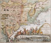 1730 ORIGINAL SEUTTER MAP NEW
 ENGLAND, NYOriginal 1730 hand-colored map in Latin and Dutch "Recens edita totius Novi Belgii in America Septentrionali," by Matthew Sutter (German), illustrating the north-eastern region of what is now the United States and a small part of Canada showing some towns and some poor cartography. A cartouche to the left of the title shows native Americans and gods bringing gifts to the King of England. Underneath the cartouche is a bird's-eye view of New York City ("Neu Jorck five Neu Amsterdam"). Dotted lines delineate some state boundaries. Scattered across the map are named locations of many Indian Tribes, some easily translated (Irocois= Iroquois, Mahikans= Mohicans, Sennecaas=Senecas.) Others are more mysterious: "Sequins, Minquaas, Tockwokhs, Kuscarawaoks,Conitttekocks." There exist current reproductions of this map, but of different size and garishly colored. The map has a band of southern Canada at top, and ends near the Virginia border at the bottom. It is 25-1/2" x 20-1/2" paper size with 21-3/4" x 18-3/4" image size. Unframed. Image shows plate edge depression in paper around perimeter. This is apparently the second state map missing the words "Chalcographie Augustani" at the bottom of the title with that area shaded in with vertical lines. Excellent condition, no foxing. The very edge of the paper shows some age darkening, otherwise it is evenly off-white. The map must have been folded into quarters; fold marks still show, but none are separating and they are barely visible. Hand coloring quite good. shipping info This item will need to be shipped by a packing company of your choice. We maintain a list of reliable shippers, or you may choose your own.
1730 ORIGINAL SEUTTER MAP NEW
1730 ORIGINAL SEUTTER MAP NEW ENGLAND, NYOriginal 1730 hand-colored map in Latin and Dutch "Recens edita totius Novi Belgii in America Septentrionali," by Matthew Sutter (German), illustrating the north-eastern region of what is now the United States and a small part of Canada showing some towns and some poor cartography. A cartouche to the left of the title shows native Americans and gods bringing gifts to the King of England. Underneath the cartouche is a bird's-eye view of New York City ("Neu Jorck five Neu Amsterdam"). Dotted lines delineate some state boundaries. Scattered across the map are named locations of many Indian Tribes, some easily translated (Irocois= Iroquois, Mahikans= Mohicans, Sennecaas=Senecas.) Others are more mysterious: "Sequins, Minquaas, Tockwokhs, Kuscarawaoks,Conitttekocks." There exist current reproductions of this map, but of different size and garishly colored. The map has a band of southern Canada at top, and ends near the Virginia border at the bottom. It is 25-1/2" x 20-1/2" paper size with 21-3/4" x 18-3/4" image size. Unframed. Image shows plate edge depression in paper around perimeter. This is apparently the second state map missing the words "Chalcographie Augustani" at the bottom of the title with that area shaded in with vertical lines. Excellent condition, no foxing. The very edge of the paper shows some age darkening, otherwise it is evenly off-white. The map must have been folded into quarters; fold marks still show, but none are separating and they are barely visible. Hand coloring quite good. shipping info This item will need to be shipped by a packing company of your choice. We maintain a list of reliable shippers, or you may choose your own. -
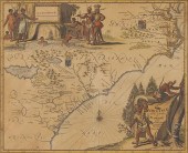 Arnoldus Montanus Map of
 Southeastern Coast''Virginiae partis australis et Floridae partis orientalis...Nova Descriptio '' Amsterdam 1671 a hand-colored double-page copperplate engraving showing Virginia as an English possession and South Carolina as belonging to France. Sheet: 12 3/8 x 14 9/16 in.; Plate 11 3/8'' x 14 '' in. Presented behind mat in wooden frame.Sheet 12 3/8 xLightstruck showing mat's outline; even browning; colors vibrant; a few small marginal splits.
Arnoldus Montanus Map of
Arnoldus Montanus Map of Southeastern Coast''Virginiae partis australis et Floridae partis orientalis...Nova Descriptio '' Amsterdam 1671 a hand-colored double-page copperplate engraving showing Virginia as an English possession and South Carolina as belonging to France. Sheet: 12 3/8 x 14 9/16 in.; Plate 11 3/8'' x 14 '' in. Presented behind mat in wooden frame.Sheet 12 3/8 xLightstruck showing mat's outline; even browning; colors vibrant; a few small marginal splits. -
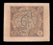
 GERARD MERCATOR, FLEMISH 1512-1594,
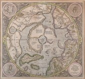
 SEPTENTRIONALIUM TERRARUM DESCRIPTIO - NORTH POLE, 1635, HAND COLORED COPPER ENGRAVING, FRAME: 17 1/2 X 22 X 22 IN. (44.5 X 55.9 X 55.9 CM.)GERARD MERCATOR, FLEMISH, 1512-1594 SEPTENTRIONALIUM TERRARUM DESCRIPTIO - NORTH POLE, 1635, Hand colored copper engraving Hand colored copper engraving Dimensions: Frame: 17 1/2 x 22 x 22 in. (44.5 x 55.9 x 55.9 cm.) Provenance: Private Maryland and Massachusetts Estate Collection
GERARD MERCATOR, FLEMISH 1512-1594,
GERARD MERCATOR, FLEMISH 1512-1594, SEPTENTRIONALIUM TERRARUM DESCRIPTIO - NORTH POLE, 1635, HAND COLORED COPPER ENGRAVING, FRAME: 17 1/2 X 22 X 22 IN. (44.5 X 55.9 X 55.9 CM.)GERARD MERCATOR, FLEMISH, 1512-1594 SEPTENTRIONALIUM TERRARUM DESCRIPTIO - NORTH POLE, 1635, Hand colored copper engraving Hand colored copper engraving Dimensions: Frame: 17 1/2 x 22 x 22 in. (44.5 x 55.9 x 55.9 cm.) Provenance: Private Maryland and Massachusetts Estate Collection -
 SEBASTIAN MUNSTER - 16TH CENTURY
 PTOLEMAIC MAP OF THE W...Sebastian Münster (1488-1552), Ptolemeisch General Tafel/die halbe kugel der Welt begreiffende , Basel, circa 1578, decorative border with twelve headwinds, engraving on laid paper with hand color, sheet 14-1/2 x 16-5/8 in.; gilt wood frame, 19 x 21 in. Condition: hinged in on mat, light toning and wear to edges, minor handling creases, a few small tears and reinforcements at edges; frame with minimal wear
SEBASTIAN MUNSTER - 16TH CENTURY
SEBASTIAN MUNSTER - 16TH CENTURY PTOLEMAIC MAP OF THE W...Sebastian Münster (1488-1552), Ptolemeisch General Tafel/die halbe kugel der Welt begreiffende , Basel, circa 1578, decorative border with twelve headwinds, engraving on laid paper with hand color, sheet 14-1/2 x 16-5/8 in.; gilt wood frame, 19 x 21 in. Condition: hinged in on mat, light toning and wear to edges, minor handling creases, a few small tears and reinforcements at edges; frame with minimal wear -
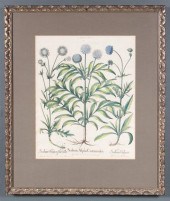 Basilius Besler German 1561-1629
 ''Scabiosa Alpina Centauroides'' Plate 257 from the ''Hortus Eystettensis'' hand colored engraving with old notations added in English 19 3/4 x 15 1/2 in. framed Estimate $ 300-500 Wrinkling age appropriate wear. Paintings have not been examined by blacklight.
Basilius Besler German 1561-1629
Basilius Besler German 1561-1629 ''Scabiosa Alpina Centauroides'' Plate 257 from the ''Hortus Eystettensis'' hand colored engraving with old notations added in English 19 3/4 x 15 1/2 in. framed Estimate $ 300-500 Wrinkling age appropriate wear. Paintings have not been examined by blacklight. -
 Northw
Northw
Northw -
 Sebastian Munster, 'India Extrema'.
 1550. Hand-colored early Ptolomaeic style map of Asia. Image measures 10x13.25'' with overall page measurement of 11.75 x 14.5''. Adhered to backing paper at top left corner. Some stains and discoloration throughout and several worm holes in upper left corner, small tear in margin above word 'regionis' at top.
Sebastian Munster, 'India Extrema'.
Sebastian Munster, 'India Extrema'. 1550. Hand-colored early Ptolomaeic style map of Asia. Image measures 10x13.25'' with overall page measurement of 11.75 x 14.5''. Adhered to backing paper at top left corner. Some stains and discoloration throughout and several worm holes in upper left corner, small tear in margin above word 'regionis' at top. -
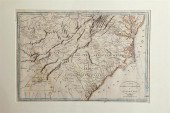 Rare early map: Southeastern United
 States Carte des Provinces Meridionales Paris circa 1807 CARTE DES PROVINCES MERIDIONALES DES ETATS UNIS. Matted framed and partially colored. sight size: H14'' W20'' overall: H23 1/2'' W29 3/4'' Provenance: South Carolina private collection. Mend on right side and at top center; multiple creases; stain at lower left and mid left; various small holes and repaired tears throughout; piece may be either backed or encased in conservation paper; not examined out of frame. Back   Inquiry    Previous Item  Next Item © Charlton Hall Auctions. Images descriptions and condition reports used on this site are original copyright material and are not to be reproduced without permission. For further information telephone 803.779.5678   © 2012 CHARLTON HALL GALLERIES INC.
Rare early map: Southeastern United
Rare early map: Southeastern United States Carte des Provinces Meridionales Paris circa 1807 CARTE DES PROVINCES MERIDIONALES DES ETATS UNIS. Matted framed and partially colored. sight size: H14'' W20'' overall: H23 1/2'' W29 3/4'' Provenance: South Carolina private collection. Mend on right side and at top center; multiple creases; stain at lower left and mid left; various small holes and repaired tears throughout; piece may be either backed or encased in conservation paper; not examined out of frame. Back   Inquiry    Previous Item  Next Item © Charlton Hall Auctions. Images descriptions and condition reports used on this site are original copyright material and are not to be reproduced without permission. For further information telephone 803.779.5678   © 2012 CHARLTON HALL GALLERIES INC. -
 MAP, JOHANN BAPTIST HOMANN Johann
 Baptist Homann (German, 1663-1724), "Totius Americae Septentrionalis et Meridionalis, 1710," copper engraved map with hand coloring, possibly a later printing, overall (with frame): 21"h x 24"w
MAP, JOHANN BAPTIST HOMANN Johann
MAP, JOHANN BAPTIST HOMANN Johann Baptist Homann (German, 1663-1724), "Totius Americae Septentrionalis et Meridionalis, 1710," copper engraved map with hand coloring, possibly a later printing, overall (with frame): 21"h x 24"w -
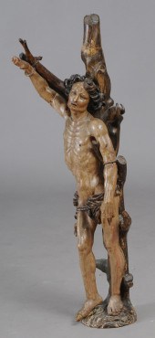 CONTINENTAL CARVED POLYCHROME
 FIGURE OF ST. SEBASTIAN The nude saint wearing a rope-tied loin cloth and tethered to a tree. Provenance: Property from Salander-O'Reilly Galleries' Collection consigned by the Trustee. 47 x 14 x 8 3/4 in.
CONTINENTAL CARVED POLYCHROME
CONTINENTAL CARVED POLYCHROME FIGURE OF ST. SEBASTIAN The nude saint wearing a rope-tied loin cloth and tethered to a tree. Provenance: Property from Salander-O'Reilly Galleries' Collection consigned by the Trustee. 47 x 14 x 8 3/4 in. -
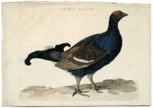 Cornelius Nozeman engraving
 (1712-1786) and Jan Christiaan Sepp (1739-1798), from Nederlandsche Vogelen, Amsterdam, 1770-1829: Tetrao, Tetrix, Mas., hand-colored engraving, 14 x 20-1/4 in. Paper tape verso edges, stain, unevenly trimmed at top, handling grime, light foxing and toning. Walter C. Barnwell Collection (label verso)
Cornelius Nozeman engraving
Cornelius Nozeman engraving (1712-1786) and Jan Christiaan Sepp (1739-1798), from Nederlandsche Vogelen, Amsterdam, 1770-1829: Tetrao, Tetrix, Mas., hand-colored engraving, 14 x 20-1/4 in. Paper tape verso edges, stain, unevenly trimmed at top, handling grime, light foxing and toning. Walter C. Barnwell Collection (label verso) -
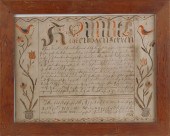 Southeastern Pennsylvania ink and
 watercolor fraktur dated 1811 the central script flanked by floral vines and birds 12" x 16". ?
Southeastern Pennsylvania ink and
Southeastern Pennsylvania ink and watercolor fraktur dated 1811 the central script flanked by floral vines and birds 12" x 16". ? -
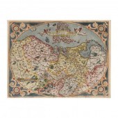
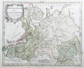 A framed, hand colored map of
 northeastern Europe and north western Russia by Robert de Vaugondy, dated 1762. Titled Partie Septentrionale de la Russie Europeenne ou sont distinguees exactement toutes les Provinces. Not examined out of frame.
A framed, hand colored map of
A framed, hand colored map of northeastern Europe and north western Russia by Robert de Vaugondy, dated 1762. Titled Partie Septentrionale de la Russie Europeenne ou sont distinguees exactement toutes les Provinces. Not examined out of frame. -
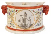 A DERBY SEMI-CIRCULAR JARDINIÈRE
 circa 1810, painted by Billingsley in sepia with two nymphs dressing a bust of Pan, the border with cornflowers, cornucopiae, with orange borders and rams-mask handles, 13.5cm high
A DERBY SEMI-CIRCULAR JARDINIÈRE
A DERBY SEMI-CIRCULAR JARDINIÈRE circa 1810, painted by Billingsley in sepia with two nymphs dressing a bust of Pan, the border with cornflowers, cornucopiae, with orange borders and rams-mask handles, 13.5cm high -
 Sebastian Münster 1488–1552.
 Novae Insulae XXVI Nova Tabula from the Cosmographia. 1540 / c. 1562, hand-colored woodcut. 11¾ h × 14¾ w in. result: $3,750. estimate: $2,500–3,500. Double-page woodcut map of the Western Hemisphere, showing North and South America, Magellan’s ship Victoria in the Pacific, flags of Portugal and Spain, printed latitude and longitude bars at the margin, Latin text verso, with later hand-color. Apparent sixth state of Münster's famous first true map of the continental Americas. Provenance: Estate of Florence Knoll Bassett
Sebastian Münster 1488–1552.
Sebastian Münster 1488–1552. Novae Insulae XXVI Nova Tabula from the Cosmographia. 1540 / c. 1562, hand-colored woodcut. 11¾ h × 14¾ w in. result: $3,750. estimate: $2,500–3,500. Double-page woodcut map of the Western Hemisphere, showing North and South America, Magellan’s ship Victoria in the Pacific, flags of Portugal and Spain, printed latitude and longitude bars at the margin, Latin text verso, with later hand-color. Apparent sixth state of Münster's famous first true map of the continental Americas. Provenance: Estate of Florence Knoll Bassett -
 ORTELIUS, ABRAHAM. DESCRIPTIO
 GERMANIAE INFERIORIS From Theatrum Orbis Terrarum (Antwerp, late 16th century), hand-colored copperplate engraving with Latin text on the verso, depicting the North Sea coastal region that incorporates Holland, Belgium, and Luxembourg. Presented behind mat in double-sided wooden frame with gilt liner.
ORTELIUS, ABRAHAM. DESCRIPTIO
ORTELIUS, ABRAHAM. DESCRIPTIO GERMANIAE INFERIORIS From Theatrum Orbis Terrarum (Antwerp, late 16th century), hand-colored copperplate engraving with Latin text on the verso, depicting the North Sea coastal region that incorporates Holland, Belgium, and Luxembourg. Presented behind mat in double-sided wooden frame with gilt liner. -
 AN ANTIQUE MAP, "INSULæ AMERICANæ
 IN OCEANO SEPTENTRION...AN ANTIQUE MAP, "Insulæ Americanæ in Oceano septentrionali ae Regiones Adiacentes a C. de May usque ad Lineam Æquinoctianlem," 18TH CENTURY, hand color engraving on paper, after Nicholas Vischer (1618-1679), a reprint by Peter Schenk the Younger (1693-1775), hand numbered seventeen in ink in margin. 24" x 21" Condition: Some toning at edges, some tears at center, expected surface wear, pencil marks, but overall in good condition, wear commensurate with age. Simpson Galleries strongly encourages in-person inspection of items by the bidder. Statements by Simpson Galleries regarding the condition of objects are for guidance only and should not be relied upon as statements of fact and do not constitute a representation, warranty, or assumption of liability by Simpson Galleries. All lots offered are sold "AS IS."
AN ANTIQUE MAP, "INSULæ AMERICANæ
AN ANTIQUE MAP, "INSULæ AMERICANæ IN OCEANO SEPTENTRION...AN ANTIQUE MAP, "Insulæ Americanæ in Oceano septentrionali ae Regiones Adiacentes a C. de May usque ad Lineam Æquinoctianlem," 18TH CENTURY, hand color engraving on paper, after Nicholas Vischer (1618-1679), a reprint by Peter Schenk the Younger (1693-1775), hand numbered seventeen in ink in margin. 24" x 21" Condition: Some toning at edges, some tears at center, expected surface wear, pencil marks, but overall in good condition, wear commensurate with age. Simpson Galleries strongly encourages in-person inspection of items by the bidder. Statements by Simpson Galleries regarding the condition of objects are for guidance only and should not be relied upon as statements of fact and do not constitute a representation, warranty, or assumption of liability by Simpson Galleries. All lots offered are sold "AS IS." -
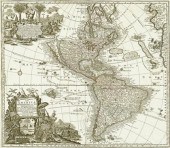
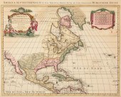 PIETER COVENS AND CORNELIU MORTIER,
 C. 1740, MAPPieter Covens and Corneliu Mortier, "L'Amerique Septentrionale.../America Septentrionali...", Amsterdam, c. 1740, hand-colored engraved map, after Delisle s seminal map of 1700, 18 1/2 in. x 23 in
PIETER COVENS AND CORNELIU MORTIER,
PIETER COVENS AND CORNELIU MORTIER, C. 1740, MAPPieter Covens and Corneliu Mortier, "L'Amerique Septentrionale.../America Septentrionali...", Amsterdam, c. 1740, hand-colored engraved map, after Delisle s seminal map of 1700, 18 1/2 in. x 23 in
...many more examples with full details are available to our members - Learn more
Easy & Visual methods to Identify & Appraise Antiques & Collectibles
EASY. FAST. ACCURATE.
Research at its best
We are here to help!
Our research tools include:

Thousands of makers marks for PORCELAIN, POTTERY CHINAWARE, FIGURINES, VASES
see details...

Thousands of marks & hallmarks for SILVER & JEWELRY, PEWTER, PRECIOUS METALS, SILVERPLATE
see details...
