Pricing Guides & Dictionary of Makers Marks for Antiques & Collectibles
A few examples of appraisal values for
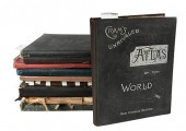
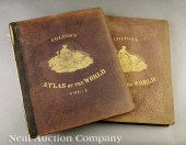
THE ATLAS COMPANY
Search our price guide for your own treasures
-
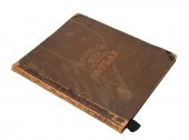
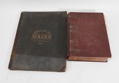 2PC CENTURY CO. & J.H. STUART
 ATLASES United States,1893-1899Includes "The Century Atlas of the World" published by The Century Co. in 1899, and a "Maine State Atlas" published by J.H. Stuart & Co. 1893.
2PC CENTURY CO. & J.H. STUART
2PC CENTURY CO. & J.H. STUART ATLASES United States,1893-1899Includes "The Century Atlas of the World" published by The Century Co. in 1899, and a "Maine State Atlas" published by J.H. Stuart & Co. 1893. -
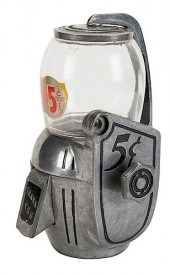
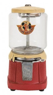 ATLAS MFG. AND SALES CO. 1 CENT
 ATLAS DELUXE BULK VENDO...Atlas Mfg. and Sales Co. 1 Cent Atlas Deluxe Bulk Vendor. Cleveland, ca. 1940. Aluminum base wrinkle painted red and yellow and cast iron lid. Lock and key. Working. Very good.
ATLAS MFG. AND SALES CO. 1 CENT
ATLAS MFG. AND SALES CO. 1 CENT ATLAS DELUXE BULK VENDO...Atlas Mfg. and Sales Co. 1 Cent Atlas Deluxe Bulk Vendor. Cleveland, ca. 1940. Aluminum base wrinkle painted red and yellow and cast iron lid. Lock and key. Working. Very good. -
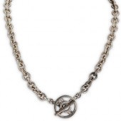 TIFFANY AND CO. "ATLAS" STERLING
 SILVER NECKLACEDESCRIPTION: A Tiffany and Co. sterling silver chain linked necklace, decorated with a "Atlas" pendant closure. Stamped "Atlas Tiffany and Co. Sterling 2003" Total Weight: 65 Grams CIRCA: 2003 ORIGIN: USA DIMENSIONS: L: 18" Have a similar item to sell? Contact: Info@Akibaantiques.com. CONDITION: Great condition. See lot description for details on item condition. More detailed condition requests can be obtained via email (info@akibaantiques.com) or SMS (305) 333-4134. Any condition statement given, as a courtesy to a client, is only an opinion and should not be treated as a statement of fact. Akiba Antiques shall have no responsibility for any error or omission. Have a similar item to sell? Contact: Info@Akibaantiques.com.
TIFFANY AND CO. "ATLAS" STERLING
TIFFANY AND CO. "ATLAS" STERLING SILVER NECKLACEDESCRIPTION: A Tiffany and Co. sterling silver chain linked necklace, decorated with a "Atlas" pendant closure. Stamped "Atlas Tiffany and Co. Sterling 2003" Total Weight: 65 Grams CIRCA: 2003 ORIGIN: USA DIMENSIONS: L: 18" Have a similar item to sell? Contact: Info@Akibaantiques.com. CONDITION: Great condition. See lot description for details on item condition. More detailed condition requests can be obtained via email (info@akibaantiques.com) or SMS (305) 333-4134. Any condition statement given, as a courtesy to a client, is only an opinion and should not be treated as a statement of fact. Akiba Antiques shall have no responsibility for any error or omission. Have a similar item to sell? Contact: Info@Akibaantiques.com. -
 (ATLAS) BURDETT S. S.
 Geographical and Political Atlas of the States and Territories of the United States of America in which the Public Land Surveys are Now in Operation. Washington: Department of the Interior 1876. Atlas folio 3/4 morocco over cloth gilt-lettered. With 19 hand-colored engraved maps after Julius Bien. Wear and fading to boards with some loss to spine; marginal dampstaining affecting some plates; light interior soiling; minor foxing.
(ATLAS) BURDETT S. S.
(ATLAS) BURDETT S. S. Geographical and Political Atlas of the States and Territories of the United States of America in which the Public Land Surveys are Now in Operation. Washington: Department of the Interior 1876. Atlas folio 3/4 morocco over cloth gilt-lettered. With 19 hand-colored engraved maps after Julius Bien. Wear and fading to boards with some loss to spine; marginal dampstaining affecting some plates; light interior soiling; minor foxing. -
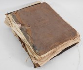 6PC ASSORTED ANTIQUE 1870'S ATLASES
 United States,1870-1874Includes "Atlas of the State of Massachusetts" published 1870, an "Atlas of the State of Massachusetts" published 1871, an "Atlas of the City of Salem Mass." by G.M. Hopkins & Co. 1874, an "Atlas of York Co. Maine" published by Sanford, Evans & Co. 1872, an "Atlas of The State of Rhode Island" by D.G. Beers & Co. 1870, and an "Atlas of Worcester County Mass." by F.W. Beers & Co 1870.
6PC ASSORTED ANTIQUE 1870'S ATLASES
6PC ASSORTED ANTIQUE 1870'S ATLASES United States,1870-1874Includes "Atlas of the State of Massachusetts" published 1870, an "Atlas of the State of Massachusetts" published 1871, an "Atlas of the City of Salem Mass." by G.M. Hopkins & Co. 1874, an "Atlas of York Co. Maine" published by Sanford, Evans & Co. 1872, an "Atlas of The State of Rhode Island" by D.G. Beers & Co. 1870, and an "Atlas of Worcester County Mass." by F.W. Beers & Co 1870. -
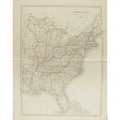
 (ATLAS) MORSE SIDNEY E. An Atlas of
 the United States on an Improved Plan; Consisting of Ten Maps with a Complete Index to Each and a General Map of the Whole Country. New-Haven: N. & S.S. Jocelyn 1823. 4to original half red calf pastedown label to upper board. With 11 engraved maps one double-page each with facing letterpress indices hand-colored in outline. Wear and soiling to boards; spine chipped with some loss; foxing; scattered brownspotting; offsetting from plates.
(ATLAS) MORSE SIDNEY E. An Atlas of
(ATLAS) MORSE SIDNEY E. An Atlas of the United States on an Improved Plan; Consisting of Ten Maps with a Complete Index to Each and a General Map of the Whole Country. New-Haven: N. & S.S. Jocelyn 1823. 4to original half red calf pastedown label to upper board. With 11 engraved maps one double-page each with facing letterpress indices hand-colored in outline. Wear and soiling to boards; spine chipped with some loss; foxing; scattered brownspotting; offsetting from plates. -
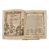 [ATLAS] KITCHIN, THOMAS & JEFFERYS,
 THOMAS. The Small English Atlas Estimate:$1,500-$2,500
[ATLAS] KITCHIN, THOMAS & JEFFERYS,
[ATLAS] KITCHIN, THOMAS & JEFFERYS, THOMAS. The Small English Atlas Estimate:$1,500-$2,500 -
 1891 GRANT'S BANKERS' & BROKERS'
 RAILROAD ATLAS New York,1891"Grant's, Bankers' & Brokers' Railroad Atlas" compiled and published by A.A. Grant in 1891.
1891 GRANT'S BANKERS' & BROKERS'
1891 GRANT'S BANKERS' & BROKERS' RAILROAD ATLAS New York,1891"Grant's, Bankers' & Brokers' Railroad Atlas" compiled and published by A.A. Grant in 1891. -
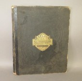
 GROUP OF 10 LATE 19TH, EARLY 20TH
 CENTURY ATLASESdated 1886, 1899, 1905, 1907, 1911, 1912, 1925, 1929; including: Rand McNally World Atlas , 1929, in full blindstamped green cloth; Cram's Unrivaled Atlas of the World, San Francisco: Cram for San Francisco Examiner, 1911, in original blindstamped cloth with silver decorations on upper cover; and others Provenance: Humber Family, North Carolina Condition: all in good to very good condition, wear to extremities, bumped corners
GROUP OF 10 LATE 19TH, EARLY 20TH
GROUP OF 10 LATE 19TH, EARLY 20TH CENTURY ATLASESdated 1886, 1899, 1905, 1907, 1911, 1912, 1925, 1929; including: Rand McNally World Atlas , 1929, in full blindstamped green cloth; Cram's Unrivaled Atlas of the World, San Francisco: Cram for San Francisco Examiner, 1911, in original blindstamped cloth with silver decorations on upper cover; and others Provenance: Humber Family, North Carolina Condition: all in good to very good condition, wear to extremities, bumped corners -
 1894 RAND MCNALLY & CO ATLAS OF THE
 WORLD United States,1894"Rand, McNally & Co.'s Atlas of the World" published by Rand, McNally & Company in 1894.
1894 RAND MCNALLY & CO ATLAS OF THE
1894 RAND MCNALLY & CO ATLAS OF THE WORLD United States,1894"Rand, McNally & Co.'s Atlas of the World" published by Rand, McNally & Company in 1894. -
 (ATLAS) CHARLE J. B. L. Nouvel
 atlas national de la France. Paris: Dauty 1833. Folio quarter calf over marbled boards. With double-page engraved title and 78 double-page engraved maps hand-colored in outline. Rubbing to boards; joints cracked; ends chipped; bookseller's sticker tipped to front pastedown; ghosting to versos of plates; intermittent light brownspotting.
(ATLAS) CHARLE J. B. L. Nouvel
(ATLAS) CHARLE J. B. L. Nouvel atlas national de la France. Paris: Dauty 1833. Folio quarter calf over marbled boards. With double-page engraved title and 78 double-page engraved maps hand-colored in outline. Rubbing to boards; joints cracked; ends chipped; bookseller's sticker tipped to front pastedown; ghosting to versos of plates; intermittent light brownspotting. -
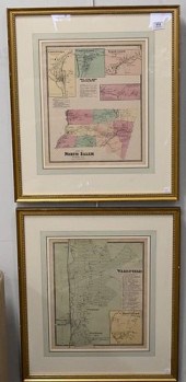
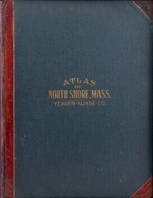 "ATLAS OF THE NORTH SHORE BEVERLY
 TO MAGNOLIA ESSEX CO. MASS.""ATLAS OF THE NORTH SHORE BEVERLY TO MAGNOLIA ESSEX CO. MASS.", Compiled and published by Yeager-Klinge Co. Engineers & Publishers 1919. Housed in a contemporary cloth-covered box with marbled interior. All 19 plates included. Provenance: Property of a direct descendant of Thomas Jefferson, the contents of the Brick House at Coolidge Point, Manchester by the Sea, Massachusetts.
"ATLAS OF THE NORTH SHORE BEVERLY
"ATLAS OF THE NORTH SHORE BEVERLY TO MAGNOLIA ESSEX CO. MASS.""ATLAS OF THE NORTH SHORE BEVERLY TO MAGNOLIA ESSEX CO. MASS.", Compiled and published by Yeager-Klinge Co. Engineers & Publishers 1919. Housed in a contemporary cloth-covered box with marbled interior. All 19 plates included. Provenance: Property of a direct descendant of Thomas Jefferson, the contents of the Brick House at Coolidge Point, Manchester by the Sea, Massachusetts. -
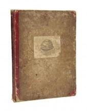
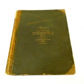 ''Atlas of The City of Springfield
 Massachusetts'' 1899 folio worn.
''Atlas of The City of Springfield
''Atlas of The City of Springfield Massachusetts'' 1899 folio worn. -
 (ATLAS) BUTLER SAMUEL An Atlas of
 Antient Geography. Philadelphia: Carey Lea & Blanchard 1834. 8vo 3/4 leatherette over marbled boards printed pastedown label to upper board. With 20 hand-colored engraved maps and one black and white plan. Hinges cracked; rubbing to boards; manuscript ex-libris to f.f.e.p.
(ATLAS) BUTLER SAMUEL An Atlas of
(ATLAS) BUTLER SAMUEL An Atlas of Antient Geography. Philadelphia: Carey Lea & Blanchard 1834. 8vo 3/4 leatherette over marbled boards printed pastedown label to upper board. With 20 hand-colored engraved maps and one black and white plan. Hinges cracked; rubbing to boards; manuscript ex-libris to f.f.e.p. -
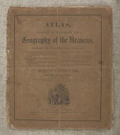
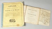
 ATLAS, DESIGNED TO ILLUSTRATE THE
 GEOGRAPHY OF THE HEAVENS NEW YORK, CIRCA 1835 16.5" X 14.5".ATLAS, DESIGNED TO ILLUSTRATE THE GEOGRAPHY OF THE HEAVENS, New York, Circa 1835, Published by Huntington and Savage, New York. By Elijah Burritt. Includes eight plates, six hand-colored and two black and white. Dimensions: 16.5" x 14.5".
ATLAS, DESIGNED TO ILLUSTRATE THE
ATLAS, DESIGNED TO ILLUSTRATE THE GEOGRAPHY OF THE HEAVENS NEW YORK, CIRCA 1835 16.5" X 14.5".ATLAS, DESIGNED TO ILLUSTRATE THE GEOGRAPHY OF THE HEAVENS, New York, Circa 1835, Published by Huntington and Savage, New York. By Elijah Burritt. Includes eight plates, six hand-colored and two black and white. Dimensions: 16.5" x 14.5". -
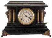 THE ATLAS MANUFACTURING CO. 5
 CENT MANTLE CLOCK TOKEN T...The Atlas Manufacturing Co. 5 Cent Mantle Clock Token Trade Stimulator. Cincinnati, ca. 1910. Fancy mantle clock would dispense a token at random intervals good for a certain amount in trade. No lock or key. With a key to wind the clock. Back door replaced, cash box new. No tokens. Clock not tested.
THE ATLAS MANUFACTURING CO. 5
THE ATLAS MANUFACTURING CO. 5 CENT MANTLE CLOCK TOKEN T...The Atlas Manufacturing Co. 5 Cent Mantle Clock Token Trade Stimulator. Cincinnati, ca. 1910. Fancy mantle clock would dispense a token at random intervals good for a certain amount in trade. No lock or key. With a key to wind the clock. Back door replaced, cash box new. No tokens. Clock not tested. -
 [American World Atlas] Colton's
 Atlas of the World Illustrating Physical and Political Geography J.H. Colton and Company No. 172 William New York 1856 2 volumes folio (18 1/2 in. x 16 in.) complete with over 100 hand-colored engraved plates and allegorical vignettes note: boards detached.
[American World Atlas] Colton's
[American World Atlas] Colton's Atlas of the World Illustrating Physical and Political Geography J.H. Colton and Company No. 172 William New York 1856 2 volumes folio (18 1/2 in. x 16 in.) complete with over 100 hand-colored engraved plates and allegorical vignettes note: boards detached. -
 JOHNSON'S NEW ILLUSTRATED FAMILY
 ATLAS. ''Compiled Drawn and Engraved under the supervision J.H. Colton and A.J. Johnson New York 1862''. Cloth boards and leather spine complete with 99 maps mostly handcolored. 18 1/2'' h. 15'' w. Some foxing and seperation from binding.
JOHNSON'S NEW ILLUSTRATED FAMILY
JOHNSON'S NEW ILLUSTRATED FAMILY ATLAS. ''Compiled Drawn and Engraved under the supervision J.H. Colton and A.J. Johnson New York 1862''. Cloth boards and leather spine complete with 99 maps mostly handcolored. 18 1/2'' h. 15'' w. Some foxing and seperation from binding. -
 Atlas design to Illustrate the
 Geography of the Heavens Francis Huntington 1850. ?
Atlas design to Illustrate the
Atlas design to Illustrate the Geography of the Heavens Francis Huntington 1850. ? -
 The Atlas to Guthrie's System of
 Geography, c. 1785. Folio, cont. half calf (spine worn). Engraved plate of an armillary sphere and 24 double page or folding engraved maps, hand coloured in outline. Additional hand coloured folding map of Upper and Lower Canada, 1832 at end/Provenance: Spetchley Park
The Atlas to Guthrie's System of
The Atlas to Guthrie's System of Geography, c. 1785. Folio, cont. half calf (spine worn). Engraved plate of an armillary sphere and 24 double page or folding engraved maps, hand coloured in outline. Additional hand coloured folding map of Upper and Lower Canada, 1832 at end/Provenance: Spetchley Park -
 MITCHELL ATLAS, 1867[Mitchell
 Atlas], Mitchell's New General Atlas, containing maps of the various countries of the world, plans of cities..., Philadelphia, S. Augustus Mitchell, Jr., 1867, folio (15 1/2 in. x 12 3/4 in.), 58 hand-colored lithographed maps, publisher's brown half leather with gilt-lettered cloth boards
MITCHELL ATLAS, 1867[Mitchell
MITCHELL ATLAS, 1867[Mitchell Atlas], Mitchell's New General Atlas, containing maps of the various countries of the world, plans of cities..., Philadelphia, S. Augustus Mitchell, Jr., 1867, folio (15 1/2 in. x 12 3/4 in.), 58 hand-colored lithographed maps, publisher's brown half leather with gilt-lettered cloth boards -
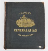 1874 COLTON'S GENERAL ATLAS New
 York,1874"Colton's General Atlas with Descriptions" with maps drawn by G. Woolworth Colton, descriptions by Richard Swainson Fisher, published by G.W. & C. B. Colton & Co. in 1874.
1874 COLTON'S GENERAL ATLAS New
1874 COLTON'S GENERAL ATLAS New York,1874"Colton's General Atlas with Descriptions" with maps drawn by G. Woolworth Colton, descriptions by Richard Swainson Fisher, published by G.W. & C. B. Colton & Co. in 1874. -
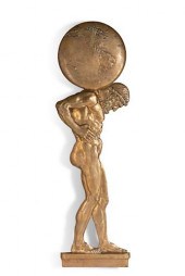 A BRONZE RELIEF PANEL OF ATLAS,
 POSSIBLY CALDWELLAn imposing bronze relief panel of Atlas possibly E.F. Caldwell, New York circa 1900 height 59 1/2in (151cm)
A BRONZE RELIEF PANEL OF ATLAS,
A BRONZE RELIEF PANEL OF ATLAS, POSSIBLY CALDWELLAn imposing bronze relief panel of Atlas possibly E.F. Caldwell, New York circa 1900 height 59 1/2in (151cm) -
 COLTON G[EORGE] WOOLWORTH
 Colton's General Atlas Containing One Hundred and Seventy Steel Plate Maps and Plans on One Hundred Imperial Folio Sheets. New York: J.H. Colton; London: Trubner 1857. Atlas folio publisher's 1/2 morocco rebacked. Complete with 96 maps (including four double-page) and color frontispiece on 101 sheets as listed in index. Some light dampstaining; spine rebacked with tape and boards worn; hinges cracked; text block shifted; chipping to edge of the map of Sussex and proceeding two sheets of text; some maps toward the ends partially detached; some very light brown spots.
COLTON G[EORGE] WOOLWORTH
COLTON G[EORGE] WOOLWORTH Colton's General Atlas Containing One Hundred and Seventy Steel Plate Maps and Plans on One Hundred Imperial Folio Sheets. New York: J.H. Colton; London: Trubner 1857. Atlas folio publisher's 1/2 morocco rebacked. Complete with 96 maps (including four double-page) and color frontispiece on 101 sheets as listed in index. Some light dampstaining; spine rebacked with tape and boards worn; hinges cracked; text block shifted; chipping to edge of the map of Sussex and proceeding two sheets of text; some maps toward the ends partially detached; some very light brown spots. -
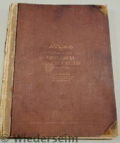
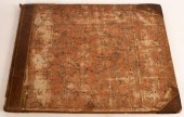
 LARGE CLOTH FABRIC COVER BOUND
 ATLAS OF NORTHAMPTOca. 1874; published by A. Pomeroy & Co., Phila. printed from surveys by and under direction of D.G. Beers, the 91 page atlas with color accent to each township and town map, 13"x 15 3/4"x 3/4"; [Provenance: ex-Warren Breining Sr., Nazarteh, PA (1939) and Walter Peters (1962)]; Condition: warping to front cover, clipped lower and upper portion of binding, some fraying to covers, overall appears complete
LARGE CLOTH FABRIC COVER BOUND
LARGE CLOTH FABRIC COVER BOUND ATLAS OF NORTHAMPTOca. 1874; published by A. Pomeroy & Co., Phila. printed from surveys by and under direction of D.G. Beers, the 91 page atlas with color accent to each township and town map, 13"x 15 3/4"x 3/4"; [Provenance: ex-Warren Breining Sr., Nazarteh, PA (1939) and Walter Peters (1962)]; Condition: warping to front cover, clipped lower and upper portion of binding, some fraying to covers, overall appears complete -
 ATLASES - BLACK, A. & C.: PUBLISHER
 BLACK'S GENERAL ATLAS comprising sixty one maps. Edinburgh, 1850. Folio, 61 maps partly coloured, maroon half morocco, rubbed; Hall, Sydney Black's General Atlas... forty four maps. Edinburgh, 1840. Folio, 44 maps, mostly hand-coloured in outline, maroon half morocco, spine gilt, slightly rubbed(2)
ATLASES - BLACK, A. & C.: PUBLISHER
ATLASES - BLACK, A. & C.: PUBLISHER BLACK'S GENERAL ATLAS comprising sixty one maps. Edinburgh, 1850. Folio, 61 maps partly coloured, maroon half morocco, rubbed; Hall, Sydney Black's General Atlas... forty four maps. Edinburgh, 1840. Folio, 44 maps, mostly hand-coloured in outline, maroon half morocco, spine gilt, slightly rubbed(2) -
 Atlas of Properties Along the
 Pennsylvania R.R. pub. by J.L. Smith Philadelphia 1900. 21"x16.5"
Atlas of Properties Along the
Atlas of Properties Along the Pennsylvania R.R. pub. by J.L. Smith Philadelphia 1900. 21"x16.5" -
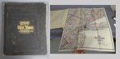
 CLOTH COVERED BOUND ATLAS OF
 LANCASTER CO., PAca. 1875; published by Evarts & Stewart, Phila. Compiled and drawn by publishing firm, printed by Hunter Printing, Phila. Including rear portion business directory and trade advertising page, the atlas with map of United States and PA, each color accented with secondary scenes of notable buildings in black and white, 14 1/2"x 17 1/2"x 1"; Condition: binding separation, fraying to edges of covers, minor soiling and foxing
CLOTH COVERED BOUND ATLAS OF
CLOTH COVERED BOUND ATLAS OF LANCASTER CO., PAca. 1875; published by Evarts & Stewart, Phila. Compiled and drawn by publishing firm, printed by Hunter Printing, Phila. Including rear portion business directory and trade advertising page, the atlas with map of United States and PA, each color accented with secondary scenes of notable buildings in black and white, 14 1/2"x 17 1/2"x 1"; Condition: binding separation, fraying to edges of covers, minor soiling and foxing -
 ''Atlas Geography of the
 Heavens'' & ''British West Indies'' 1810 ''Atlas designed to illustrate the Geography of the Heavens comprising maps and plates...'' by Elijah H. Burritt A.M. Pub. by F. J. Huntington 1836. Stain to front cover slight foxing to pages very good. ''A New Atlas of the British West Indies w/a Map of West India Islands and St. Domingo'' published by Levis & Weaver Philadelphia 1810 incomplete.Dimensions: Max. 16'' x 14''Provenance: From the collection of the former Campbell-Whittlesey House Museum.E
''Atlas Geography of the
''Atlas Geography of the Heavens'' & ''British West Indies'' 1810 ''Atlas designed to illustrate the Geography of the Heavens comprising maps and plates...'' by Elijah H. Burritt A.M. Pub. by F. J. Huntington 1836. Stain to front cover slight foxing to pages very good. ''A New Atlas of the British West Indies w/a Map of West India Islands and St. Domingo'' published by Levis & Weaver Philadelphia 1810 incomplete.Dimensions: Max. 16'' x 14''Provenance: From the collection of the former Campbell-Whittlesey House Museum.E -
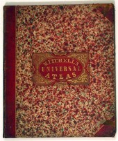 1 vol. (Mitchell's Universal
 Atlas.) A New Universal Atlas. Philadelphia: S. Augustus Mitchell, 1848. Folio, orig. red straight-grained morocco & marbled bds., gilt-lettered red morocco cover label; scuffed, extremities rubbed. With 72 sheets of color maps & c. Small portion of title page chipped - not affecting text or title vignette. Some internal spotting, light to moderate toning, minor offsetting.
1 vol. (Mitchell's Universal
1 vol. (Mitchell's Universal Atlas.) A New Universal Atlas. Philadelphia: S. Augustus Mitchell, 1848. Folio, orig. red straight-grained morocco & marbled bds., gilt-lettered red morocco cover label; scuffed, extremities rubbed. With 72 sheets of color maps & c. Small portion of title page chipped - not affecting text or title vignette. Some internal spotting, light to moderate toning, minor offsetting. -
 ATLAS MFG. AND SALES CO. 5 CENT
 BANTAM BULK VENDOR.Atlas Mfg. and Sales Co. 5 Cent Bantam Bulk Vendor. Cleveland, ca. 1947. Aluminum base and top. Original decal. Original lock and key. Working. Very good.
ATLAS MFG. AND SALES CO. 5 CENT
ATLAS MFG. AND SALES CO. 5 CENT BANTAM BULK VENDOR.Atlas Mfg. and Sales Co. 5 Cent Bantam Bulk Vendor. Cleveland, ca. 1947. Aluminum base and top. Original decal. Original lock and key. Working. Very good. -
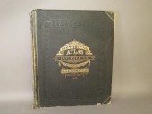
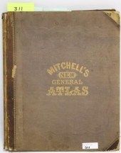 MITCHELL'S NEW GENERAL ATLAS,
 PUBLISHED BYAUGUSTUS MITCHELL, JR., PHILADELPHIA, 1869, CLOTH BOUND WITH GILT LETTERING. THE ATLAS CONTAINS 96 MAPS OF VARIOUS COUNTRIES INCLUDING U.S. CITY MAPS. OVERALL CONDITION IS VERY GOOD WITH MINOR FOXING AND TANNING. THE SPINE AND BOARD CORNERS SHOW WEAR. 16" X 13".
MITCHELL'S NEW GENERAL ATLAS,
MITCHELL'S NEW GENERAL ATLAS, PUBLISHED BYAUGUSTUS MITCHELL, JR., PHILADELPHIA, 1869, CLOTH BOUND WITH GILT LETTERING. THE ATLAS CONTAINS 96 MAPS OF VARIOUS COUNTRIES INCLUDING U.S. CITY MAPS. OVERALL CONDITION IS VERY GOOD WITH MINOR FOXING AND TANNING. THE SPINE AND BOARD CORNERS SHOW WEAR. 16" X 13". -
 SIX ATLAS OF NEW YORK AND VICINITY,
 HAND COLORED ENGRAV...Six Atlas of New York and Vicinity, hand colored engraved maps including Sommers, Patterson, Wakefield, Ossining, City Island, and North Salem, 16 3/4" x 13 3/4". Provenance: Originally from Credit Suisse's Americana Collection to present owner. Condition: All lots are sold "AS IS" The condition of lots can vary widely and are unlikely to be in a perfect condition. *No credit card payments will be accepted for silver, gold, or jewelry from buyers that have not purchased from our gallery in the past.
SIX ATLAS OF NEW YORK AND VICINITY,
SIX ATLAS OF NEW YORK AND VICINITY, HAND COLORED ENGRAV...Six Atlas of New York and Vicinity, hand colored engraved maps including Sommers, Patterson, Wakefield, Ossining, City Island, and North Salem, 16 3/4" x 13 3/4". Provenance: Originally from Credit Suisse's Americana Collection to present owner. Condition: All lots are sold "AS IS" The condition of lots can vary widely and are unlikely to be in a perfect condition. *No credit card payments will be accepted for silver, gold, or jewelry from buyers that have not purchased from our gallery in the past. -
 Atlas Block and Garage 1940 the
 photo with hand editions on masonite along with another print mounted on canvas. Largest 27 1/2 x 34 inches.
Atlas Block and Garage 1940 the
Atlas Block and Garage 1940 the photo with hand editions on masonite along with another print mounted on canvas. Largest 27 1/2 x 34 inches. -
 Cary (John) Cary's New Universal
 Atlas containing Distinct Maps of all the Principal States and Kingdoms throughout the World from the latest and best Authorities Extant, London: Printed from J Cary, 1808, landscape elephant folio (73cm wide x 62cm high), Contents, List of Subscribers, 60 engraved plates, 6 of which form double pages, original marbled boards, leather spine and corners, spine with gilt title block and six raised bands, interior hinges in tooled leather
Cary (John) Cary's New Universal
Cary (John) Cary's New Universal Atlas containing Distinct Maps of all the Principal States and Kingdoms throughout the World from the latest and best Authorities Extant, London: Printed from J Cary, 1808, landscape elephant folio (73cm wide x 62cm high), Contents, List of Subscribers, 60 engraved plates, 6 of which form double pages, original marbled boards, leather spine and corners, spine with gilt title block and six raised bands, interior hinges in tooled leather -
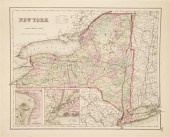
 Dated 1867 ''Atlas of New York
 and Vicinity Beers Ellis & Soule''.
Dated 1867 ''Atlas of New York
Dated 1867 ''Atlas of New York and Vicinity Beers Ellis & Soule''.
...many more examples with full details are available to our members - Learn more
Easy & Visual methods to Identify & Appraise Antiques & Collectibles
EASY. FAST. ACCURATE.
Research at its best
We are here to help!
Our research tools include:

Thousands of makers marks for PORCELAIN, POTTERY CHINAWARE, FIGURINES, VASES
see details...

Thousands of marks & hallmarks for SILVER & JEWELRY, PEWTER, PRECIOUS METALS, SILVERPLATE
see details...
