Pricing Guides & Dictionary of Makers Marks for Antiques & Collectibles
Appraise and find values for
Rare early maps: Washington D.C....
From
marks4antiques.com
- The most updated price guide and makers' marks research online
As a member, you have access to a team of experts
and assistance is always available to you for free
An example from the millions of items in our Price Guide:
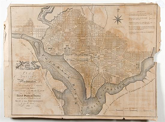
Rare early maps: Washington D.C. PLAN OF THE CITY OF WASHINGTON circa 1792 after Andrew Ellicot's plan marked: Thackara and Vallance fr. unframed plate...
This is an example from our
values4antiques price guide
We do not buy or sell any items
See more price guides
Check our other research services:
IDENTIFY WORLDWIDE MAKERS' MARKS & HALLMARKS
marks4ceramics:
Porcelain, Pottery, Chinaware, Figurines, Dolls, Vases...
marks4silver
:
Silver, Jewelry, Pewter, Silverplate, Copper & Bronze...
Explore other items from our
Antiques & Collectibles Price Guide
-
 A Very Large Collection of Maps, 19th/e
[more like this]
A Very Large Collection of Maps, 19th/e
[more like this]
-
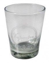 RARE ENGRAVED GLASS PRESENTATION TUMBLER
[more like this]
RARE ENGRAVED GLASS PRESENTATION TUMBLER
[more like this]
-
 HENRY MOUZON - MAP OF NORTH AND SOUTH CA
[more like this]
HENRY MOUZON - MAP OF NORTH AND SOUTH CA
[more like this]
-
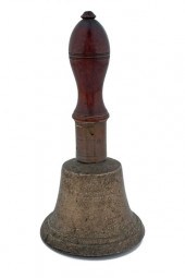 Bell Belonging to George Washington Engr
[more like this]
Bell Belonging to George Washington Engr
[more like this]
-
 A LATE MEXICAN-AMERICAN WAR ERA MAP, "MA
[more like this]
A LATE MEXICAN-AMERICAN WAR ERA MAP, "MA
[more like this]
-
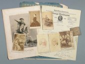 LINCOLN AND WASHINGTON CDVS, EPHEMERA7 p
[more like this]
LINCOLN AND WASHINGTON CDVS, EPHEMERA7 p
[more like this]
-
 8 TENNESSEE MILITARY & SURVEY MAPSAssort
[more like this]
8 TENNESSEE MILITARY & SURVEY MAPSAssort
[more like this]
-
 Autographs of World War II Generals Eigh
[more like this]
Autographs of World War II Generals Eigh
[more like this]
-
 AN ANTIQUE MAP, "CARTE DES VARIATIONS DE
[more like this]
AN ANTIQUE MAP, "CARTE DES VARIATIONS DE
[more like this]
-
 7 vols. Cartography - American Subjects
[more like this]
7 vols. Cartography - American Subjects
[more like this]
-
 2 FRAMED 18TH C. FADEN MAPS - GREECE & D
[more like this]
2 FRAMED 18TH C. FADEN MAPS - GREECE & D
[more like this]
-
 THE LIFE OF GEORGE WASHINGTON, BY JOHN M
[more like this]
THE LIFE OF GEORGE WASHINGTON, BY JOHN M
[more like this]
-
 MAPS: JOHN MARSHALL "THE LIFE OF GEORGE
[more like this]
MAPS: JOHN MARSHALL "THE LIFE OF GEORGE
[more like this]
-
 4 vols. (Pennsylvania Property Atlases
[more like this]
4 vols. (Pennsylvania Property Atlases
[more like this]
-
 1 vol. (Philadelphia Atlas.) Smedley, S
[more like this]
1 vol. (Philadelphia Atlas.) Smedley, S
[more like this]
-
 DU HALDE, Jean-Baptiste, (French, 1674-1
[more like this]
DU HALDE, Jean-Baptiste, (French, 1674-1
[more like this]
-
 MITCHELL. A NEW UNIVERSAL ATLAS CONTAINI
[more like this]
MITCHELL. A NEW UNIVERSAL ATLAS CONTAINI
[more like this]
-
 BICENTENNIAL PAGEANT OF GEORGE WASHINGTO
[more like this]
BICENTENNIAL PAGEANT OF GEORGE WASHINGTO
[more like this]
-
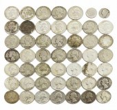 (49) U.S. SILVER QUARTERS & DIMES(lot of
[more like this]
(49) U.S. SILVER QUARTERS & DIMES(lot of
[more like this]
-
 Military Maps Illustrating the Operation
[more like this]
Military Maps Illustrating the Operation
[more like this]
-
 A Large Collection of Maps of America,
[more like this]
A Large Collection of Maps of America,
[more like this]
-
 WILLIAM WINTERBOTHAM. AN HISTORICAL, GEO
[more like this]
WILLIAM WINTERBOTHAM. AN HISTORICAL, GEO
[more like this]
-
 (AFRICAN AMERICANA) WASHINGTON BOOKER T.
[more like this]
(AFRICAN AMERICANA) WASHINGTON BOOKER T.
[more like this]
-
![[Political Americana] George W](/images/political-americana-george-washington-group--15f04a-medium.jpg) [Political Americana] George Washington
[more like this]
[Political Americana] George Washington
[more like this]
-
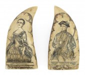 PAIR OF EXCEPTIONAL POLYCHROME SCRIMSHAW
[more like this]
PAIR OF EXCEPTIONAL POLYCHROME SCRIMSHAW
[more like this]
-
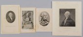 4 GEORGE WASHINGTON ENGRAVED PORTRAITSFo
[more like this]
4 GEORGE WASHINGTON ENGRAVED PORTRAITSFo
[more like this]
-
 RARE 18TH CENTURY CHINESE ATLASA rare 18
[more like this]
RARE 18TH CENTURY CHINESE ATLASA rare 18
[more like this]
-
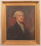 JACOB EICHHOLTZ OIL PORTRAIT OF GEORGE W
[more like this]
JACOB EICHHOLTZ OIL PORTRAIT OF GEORGE W
[more like this]
-
 2 vols. (Philadelphia Property Atlases.
[more like this]
2 vols. (Philadelphia Property Atlases.
[more like this]
-
 7 vols. Cartography: Brown, Lloyd A. Th
[more like this]
7 vols. Cartography: Brown, Lloyd A. Th
[more like this]
-
 1782 Thomas Kitchen atlas, A General Atl
[more like this]
1782 Thomas Kitchen atlas, A General Atl
[more like this]
-
 MAPS: JOHN SPEED (ENGLAND, 1552-1629), T
[more like this]
MAPS: JOHN SPEED (ENGLAND, 1552-1629), T
[more like this]
-
 6 MISSISSIPPI AND TENNESSEE RIVER MAPSSi
[more like this]
6 MISSISSIPPI AND TENNESSEE RIVER MAPSSi
[more like this]
-
 5 CIVIL WAR RELATED BOOKS1st item: Hopki
[more like this]
5 CIVIL WAR RELATED BOOKS1st item: Hopki
[more like this]
-
 5 CIVIL WAR MAPSLot of five Civil War ma
[more like this]
5 CIVIL WAR MAPSLot of five Civil War ma
[more like this]
-
 (5) TEXAS MAPS, 1850'S<br>(lot of 5
[more like this]
(5) TEXAS MAPS, 1850'S<br>(lot of 5
[more like this]
This list is limited to only a few results.
Many more items are available to our members in our
Price Guide!
Ideal research tools for Collectors, Personal Property Appraisers, Antiques & Collectibles
Dealers, Auction Houses, Museums, eBayers or
other online
sellers (Rubylane, Etsy etc) and curious minds interested in appraising & identifying collectibles

EASY. FAST. ACCURATE.
Research at its best

Our research tools include:


