Pricing Guides & Dictionary of Makers Marks for Antiques & Collectibles
Appraise and find values for
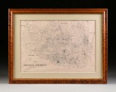
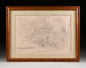
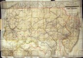
AN ANTIQUE MAP, "NEW RAILROAD MAP...
From
marks4antiques.com
- The most updated price guide and makers' marks research online
As a member, you have access to a team of experts
and assistance is always available to you for free
An example from the millions of items in our Price Guide:
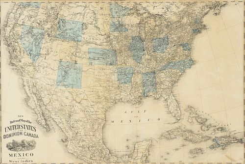
AN ANTIQUE MAP, "NEW RAILROAD MAP OF THE UNITED STATES,...AN ANTIQUE MAP, "New Railroad Map of the United States, the Dominion of Canada, Mexico and the...
This is an example from our
values4antiques price guide
We do not buy or sell any items
See more price guides
Check our other research services:
IDENTIFY WORLDWIDE MAKERS' MARKS & HALLMARKS
marks4ceramics:
Porcelain, Pottery, Chinaware, Figurines, Dolls, Vases...
marks4silver
:
Silver, Jewelry, Pewter, Silverplate, Copper & Bronze...
Explore other items from our
Antiques & Collectibles Price Guide
-
 BRITANNIA, VOL. I & II CAMDEN 1722Camden
[more like this]
BRITANNIA, VOL. I & II CAMDEN 1722Camden
[more like this]
-
 A COMPLETE SYSTEM OF GEOGRAPHY, VOL. I B
[more like this]
A COMPLETE SYSTEM OF GEOGRAPHY, VOL. I B
[more like this]
-
 IMPORTANT ANTIQUE ATLAS DU VOYAGE DE LA
[more like this]
IMPORTANT ANTIQUE ATLAS DU VOYAGE DE LA
[more like this]
-
 5 KENTUCKY AND TENNESSEE MAPS1st item: "
[more like this]
5 KENTUCKY AND TENNESSEE MAPS1st item: "
[more like this]
-
 AN ANTIQUE MAP, "RAND MCNALLY & CO.'S NE
[more like this]
AN ANTIQUE MAP, "RAND MCNALLY & CO.'S NE
[more like this]
-
 A RARE ANTIQUE CIVIL WAR ERA MAP, "PRESS
[more like this]
A RARE ANTIQUE CIVIL WAR ERA MAP, "PRESS
[more like this]
-
 AN ANTIQUE PROMOTIONAL MAP, "CORRECT MAP
[more like this]
AN ANTIQUE PROMOTIONAL MAP, "CORRECT MAP
[more like this]
-
 3 KY & TN MAPS: VANCE, TANNER, JOHNSON1s
[more like this]
3 KY & TN MAPS: VANCE, TANNER, JOHNSON1s
[more like this]
-
 AMERICAN RAILROAD COIN SILVER PRESENTATI
[more like this]
AMERICAN RAILROAD COIN SILVER PRESENTATI
[more like this]
-
 An Impressive Masterwork Andrew Clemens
[more like this]
An Impressive Masterwork Andrew Clemens
[more like this]
-
 4 TN & KY MAPS, 3 FRAMED1st item: "Tenne
[more like this]
4 TN & KY MAPS, 3 FRAMED1st item: "Tenne
[more like this]
-
 A LATE MEXICAN-AMERICAN WAR ERA MAP, "MA
[more like this]
A LATE MEXICAN-AMERICAN WAR ERA MAP, "MA
[more like this]
-
 NATIVE AMERICAN/WESTERN U.S. EXPEDITION
[more like this]
NATIVE AMERICAN/WESTERN U.S. EXPEDITION
[more like this]
-
 AN ANTIQUE RECONSTRUCTION ERA MAP, "KOSS
[more like this]
AN ANTIQUE RECONSTRUCTION ERA MAP, "KOSS
[more like this]
-
 16TH / 18TH C. EUROPEAN MAPS OF NEW SPAI
[more like this]
16TH / 18TH C. EUROPEAN MAPS OF NEW SPAI
[more like this]
-
 A Very Large Collection of Maps, 19th/e
[more like this]
A Very Large Collection of Maps, 19th/e
[more like this]
-
 8 TENNESSEE MILITARY & SURVEY MAPSAssort
[more like this]
8 TENNESSEE MILITARY & SURVEY MAPSAssort
[more like this]
-
 A FACSIMILE CADASTRAL MAP, "MAP OF HARRI
[more like this]
A FACSIMILE CADASTRAL MAP, "MAP OF HARRI
[more like this]
-
 A FACSIMILE CADASTRAL MAP, "MAP OF HARRI
[more like this]
A FACSIMILE CADASTRAL MAP, "MAP OF HARRI
[more like this]
-
 A TOPOGRAPHICAL MAP OF THE ENVIRONS OF L
[more like this]
A TOPOGRAPHICAL MAP OF THE ENVIRONS OF L
[more like this]
-
 11 PC. MAP COLLECTION: Comprising; 1- La
[more like this]
11 PC. MAP COLLECTION: Comprising; 1- La
[more like this]
-
 AN IMPORTANT REPUBLIC OF TEXAS MAP, "MAP
[more like this]
AN IMPORTANT REPUBLIC OF TEXAS MAP, "MAP
[more like this]
-
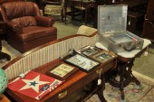
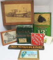 LARGE LOT OF 8 RAILROAD RELATED ITEMS, 2
[more like this]
LARGE LOT OF 8 RAILROAD RELATED ITEMS, 2
[more like this]
-
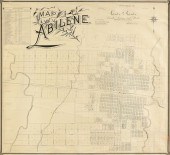 AN ANTIQUE MAP, "MAP OF ABILENE," GALVES
[more like this]
AN ANTIQUE MAP, "MAP OF ABILENE," GALVES
[more like this]
-
 3 19TH CENT. AL, KY, & TN MAPS1st item:
[more like this]
3 19TH CENT. AL, KY, & TN MAPS1st item:
[more like this]
-
 MAP AND ATLAS LOT, 3 PCS INCL. MELISH DI
[more like this]
MAP AND ATLAS LOT, 3 PCS INCL. MELISH DI
[more like this]
-
 5 CIVIL WAR MAPSLot of five Civil War ma
[more like this]
5 CIVIL WAR MAPSLot of five Civil War ma
[more like this]
-
 4 EARLY AMERICAN MAPS: OVERTON, THIERRY,
[more like this]
4 EARLY AMERICAN MAPS: OVERTON, THIERRY,
[more like this]
-
 3 pieces. Fold Maps: Colton, G.W.G. & C
[more like this]
3 pieces. Fold Maps: Colton, G.W.G. & C
[more like this]
-
![[Railroads] Railroads and Road](/images/railroads-railroads-and-roads--15f0a8-medium.jpg) [Railroads] Railroads and Roads - Bookle
[more like this]
[Railroads] Railroads and Roads - Bookle
[more like this]
-
 AN ANTIQUE RECONSTRUCTION ERA MAP, "TRAV
[more like this]
AN ANTIQUE RECONSTRUCTION ERA MAP, "TRAV
[more like this]
-
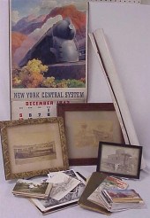 1942 Pennsylvania Railroad calendar 194
[more like this]
1942 Pennsylvania Railroad calendar 194
[more like this]
-
 RAILROAD CONDUCTOR ARCHIVE. American 20
[more like this]
RAILROAD CONDUCTOR ARCHIVE. American 20
[more like this]
-
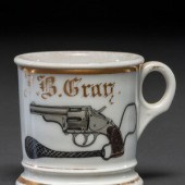 A Railroad Detective's Porcelain Occupat
[more like this]
A Railroad Detective's Porcelain Occupat
[more like this]
-
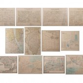 A Group of Twelve Maps of Illinois
compr
[more like this]
A Group of Twelve Maps of Illinois
compr
[more like this]
-
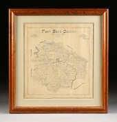 AN ANTIQUE CADASTRAL MAP, "FORT BEND COU
[more like this]
AN ANTIQUE CADASTRAL MAP, "FORT BEND COU
[more like this]
This list is limited to only a few results.
Many more items are available to our members in our
Price Guide!
Ideal research tools for Collectors, Personal Property Appraisers, Antiques & Collectibles
Dealers, Auction Houses, Museums, eBayers or
other online
sellers (Rubylane, Etsy etc) and curious minds interested in appraising & identifying collectibles

EASY. FAST. ACCURATE.
Research at its best

Our research tools include:


