Pricing Guides & Dictionary of Makers Marks for Antiques & Collectibles
Appraise and find values for
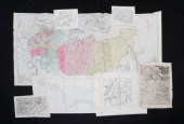
Four 18th century maps dated 1782 &...
From
marks4antiques.com
- The most updated price guide and makers' marks research online
As a member, you have access to a team of experts
and assistance is always available to you for free
An example from the millions of items in our Price Guide:
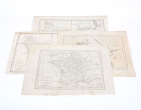
Four 18th century maps dated 1782 & 1783 by geographer J. Bayly of Denmark, France, East Indies, and West Indies. Largest 10" x 14 1/2". All maps have...
This is an example from our
values4antiques price guide
We do not buy or sell any items
See more price guides
Check our other research services:
IDENTIFY WORLDWIDE MAKERS' MARKS & HALLMARKS
marks4ceramics:
Porcelain, Pottery, Chinaware, Figurines, Dolls, Vases...
marks4silver
:
Silver, Jewelry, Pewter, Silverplate, Copper & Bronze...
Explore other items from our
Antiques & Collectibles Price Guide
-
 A Very Large Collection of Maps, 19th/e
[more like this]
A Very Large Collection of Maps, 19th/e
[more like this]
-
 1782 Thomas Kitchen atlas, A General Atl
[more like this]
1782 Thomas Kitchen atlas, A General Atl
[more like this]
-
 AN ANTIQUE MAP, "CARTE DES VARIATIONS DE
[more like this]
AN ANTIQUE MAP, "CARTE DES VARIATIONS DE
[more like this]
-
 2 FRAMED 18TH C. FADEN MAPS - GREECE & D
[more like this]
2 FRAMED 18TH C. FADEN MAPS - GREECE & D
[more like this]
-
 RARE 18TH CENTURY CHINESE ATLASA rare 18
[more like this]
RARE 18TH CENTURY CHINESE ATLASA rare 18
[more like this]
-
 1 vol. (Philadelphia Atlas.) Smedley, S
[more like this]
1 vol. (Philadelphia Atlas.) Smedley, S
[more like this]
-
 HENRY MOUZON - MAP OF NORTH AND SOUTH CA
[more like this]
HENRY MOUZON - MAP OF NORTH AND SOUTH CA
[more like this]
-
 4 vols. (Pennsylvania Property Atlases
[more like this]
4 vols. (Pennsylvania Property Atlases
[more like this]
-
 DU HALDE, Jean-Baptiste, (French, 1674-1
[more like this]
DU HALDE, Jean-Baptiste, (French, 1674-1
[more like this]
-
 MITCHELL. A NEW UNIVERSAL ATLAS CONTAINI
[more like this]
MITCHELL. A NEW UNIVERSAL ATLAS CONTAINI
[more like this]
-
 MAPS: JOHN SPEED (ENGLAND, 1552-1629), T
[more like this]
MAPS: JOHN SPEED (ENGLAND, 1552-1629), T
[more like this]
-
 A Large Collection of Maps of America,
[more like this]
A Large Collection of Maps of America,
[more like this]
-
 7 vols. French & British Travelers in A
[more like this]
7 vols. French & British Travelers in A
[more like this]
-
 6 MISSISSIPPI AND TENNESSEE RIVER MAPSSi
[more like this]
6 MISSISSIPPI AND TENNESSEE RIVER MAPSSi
[more like this]
-
 5 CIVIL WAR RELATED BOOKS1st item: Hopki
[more like this]
5 CIVIL WAR RELATED BOOKS1st item: Hopki
[more like this]
-
 8 TENNESSEE MILITARY & SURVEY MAPSAssort
[more like this]
8 TENNESSEE MILITARY & SURVEY MAPSAssort
[more like this]
-
 2 vols. (Philadelphia Property Atlases.
[more like this]
2 vols. (Philadelphia Property Atlases.
[more like this]
-
 7 vols. Cartography: Brown, Lloyd A. Th
[more like this]
7 vols. Cartography: Brown, Lloyd A. Th
[more like this]
-
 7 vols. Cartography - American Subjects
[more like this]
7 vols. Cartography - American Subjects
[more like this]
-
 Military Maps Illustrating the Operation
[more like this]
Military Maps Illustrating the Operation
[more like this]
-
 THE LIFE OF GEORGE WASHINGTON, BY JOHN M
[more like this]
THE LIFE OF GEORGE WASHINGTON, BY JOHN M
[more like this]
-
 5 CIVIL WAR MAPSLot of five Civil War ma
[more like this]
5 CIVIL WAR MAPSLot of five Civil War ma
[more like this]
-
 MAPS: JOHN MARSHALL "THE LIFE OF GEORGE
[more like this]
MAPS: JOHN MARSHALL "THE LIFE OF GEORGE
[more like this]
-
 (5) TEXAS MAPS, 1850'S<br>(lot of 5
[more like this]
(5) TEXAS MAPS, 1850'S<br>(lot of 5
[more like this]
-
 GEORGE III COATES & WAKEFIELD 18TH CENTU
[more like this]
GEORGE III COATES & WAKEFIELD 18TH CENTU
[more like this]
-
 SEVEN ENGRAVED MAPS. European, 18th-19th
[more like this]
SEVEN ENGRAVED MAPS. European, 18th-19th
[more like this]
-
 MAPS: TWO FRAMED MAPS OF ZUTPHEN, AMSTER
[more like this]
MAPS: TWO FRAMED MAPS OF ZUTPHEN, AMSTER
[more like this]
-
 THREE HAND-COLORED MAPS OF ASIATHREE HAN
[more like this]
THREE HAND-COLORED MAPS OF ASIATHREE HAN
[more like this]
-
 THREE HAND-COLORED MAPS OF ASIATHREE HAN
[more like this]
THREE HAND-COLORED MAPS OF ASIATHREE HAN
[more like this]
-
 Pair 18th century New England / Massachu
[more like this]
Pair 18th century New England / Massachu
[more like this]
-
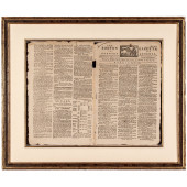 JULY 8, 1782, THE BOSTON GAZETTE MASTHEA
[more like this]
JULY 8, 1782, THE BOSTON GAZETTE MASTHEA
[more like this]
-
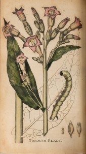 WILLIAM WINTERBOTHAM. AN HISTORICAL, GEO
[more like this]
WILLIAM WINTERBOTHAM. AN HISTORICAL, GEO
[more like this]
-
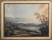 CARL L. HACKERT "VUE DE GENEVE" WATERCOL
[more like this]
CARL L. HACKERT "VUE DE GENEVE" WATERCOL
[more like this]
-
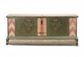 CONTINENTAL CARVED AND PAINTED WEDDING T
[more like this]
CONTINENTAL CARVED AND PAINTED WEDDING T
[more like this]
-
 1782 BOSTON, MA. AND 1795 ALEXANDRIA,VA.
[more like this]
1782 BOSTON, MA. AND 1795 ALEXANDRIA,VA.
[more like this]
-
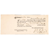
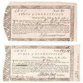 PAIR OF 1782 REVOLUTIONARY WAR CONNECTIC
[more like this]
PAIR OF 1782 REVOLUTIONARY WAR CONNECTIC
[more like this]
This list is limited to only a few results.
Many more items are available to our members in our
Price Guide!
Ideal research tools for Collectors, Personal Property Appraisers, Antiques & Collectibles
Dealers, Auction Houses, Museums, eBayers or
other online
sellers (Rubylane, Etsy etc) and curious minds interested in appraising & identifying collectibles

EASY. FAST. ACCURATE.
Research at its best

Our research tools include:


