Pricing Guides & Dictionary of Makers Marks for Antiques & Collectibles
Appraise and find values for
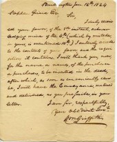
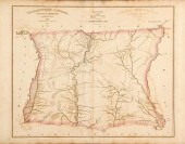
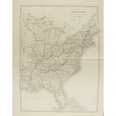
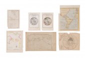
[Maps] Four items relating to...
From
marks4antiques.com
- The most updated price guide and makers' marks research online
As a member, you have access to a team of experts
and assistance is always available to you for free
An example from the millions of items in our Price Guide:
![[Maps] Four items relating to](/images/maps-four-items-relating-to--13960b-full.jpg)
[Maps] Four items relating to Maryland and Delaware including: ''A Map of Maryland & Delaware'' with inset map of Baltimore County; ''Map of Maryland &...
This is an example from our
values4antiques price guide
We do not buy or sell any items
See more price guides
Check our other research services:
IDENTIFY WORLDWIDE MAKERS' MARKS & HALLMARKS
marks4ceramics:
Porcelain, Pottery, Chinaware, Figurines, Dolls, Vases...
marks4silver
:
Silver, Jewelry, Pewter, Silverplate, Copper & Bronze...
Explore other items from our
Antiques & Collectibles Price Guide
-
 A Very Large Collection of Maps, 19th/e
[more like this]
A Very Large Collection of Maps, 19th/e
[more like this]
-
 AN ANTIQUE MAP, "CARTE DES VARIATIONS DE
[more like this]
AN ANTIQUE MAP, "CARTE DES VARIATIONS DE
[more like this]
-
 HENRY MOUZON - MAP OF NORTH AND SOUTH CA
[more like this]
HENRY MOUZON - MAP OF NORTH AND SOUTH CA
[more like this]
-
 4 vols. (Pennsylvania Property Atlases
[more like this]
4 vols. (Pennsylvania Property Atlases
[more like this]
-
 1 vol. (Philadelphia Atlas.) Smedley, S
[more like this]
1 vol. (Philadelphia Atlas.) Smedley, S
[more like this]
-
 DU HALDE, Jean-Baptiste, (French, 1674-1
[more like this]
DU HALDE, Jean-Baptiste, (French, 1674-1
[more like this]
-
 MITCHELL. A NEW UNIVERSAL ATLAS CONTAINI
[more like this]
MITCHELL. A NEW UNIVERSAL ATLAS CONTAINI
[more like this]
-
 2 FRAMED 18TH C. FADEN MAPS - GREECE & D
[more like this]
2 FRAMED 18TH C. FADEN MAPS - GREECE & D
[more like this]
-
 8 TENNESSEE MILITARY & SURVEY MAPSAssort
[more like this]
8 TENNESSEE MILITARY & SURVEY MAPSAssort
[more like this]
-
 4 pieces. Manuscript Material relating
[more like this]
4 pieces. Manuscript Material relating
[more like this]
-
 6 MISSISSIPPI AND TENNESSEE RIVER MAPSSi
[more like this]
6 MISSISSIPPI AND TENNESSEE RIVER MAPSSi
[more like this]
-
 A Large Collection of Maps of America,
[more like this]
A Large Collection of Maps of America,
[more like this]
-
 5 CIVIL WAR RELATED BOOKS1st item: Hopki
[more like this]
5 CIVIL WAR RELATED BOOKS1st item: Hopki
[more like this]
-
 2 vols. (Philadelphia Property Atlases.
[more like this]
2 vols. (Philadelphia Property Atlases.
[more like this]
-
 7 vols. Cartography: Brown, Lloyd A. Th
[more like this]
7 vols. Cartography: Brown, Lloyd A. Th
[more like this]
-
 7 vols. Cartography - American Subjects
[more like this]
7 vols. Cartography - American Subjects
[more like this]
-
 1782 Thomas Kitchen atlas, A General Atl
[more like this]
1782 Thomas Kitchen atlas, A General Atl
[more like this]
-
 Military Maps Illustrating the Operation
[more like this]
Military Maps Illustrating the Operation
[more like this]
-
 THE LIFE OF GEORGE WASHINGTON, BY JOHN M
[more like this]
THE LIFE OF GEORGE WASHINGTON, BY JOHN M
[more like this]
-
 MAPS: JOHN SPEED (ENGLAND, 1552-1629), T
[more like this]
MAPS: JOHN SPEED (ENGLAND, 1552-1629), T
[more like this]
-
 5 CIVIL WAR MAPSLot of five Civil War ma
[more like this]
5 CIVIL WAR MAPSLot of five Civil War ma
[more like this]
-
 MAPS: JOHN MARSHALL "THE LIFE OF GEORGE
[more like this]
MAPS: JOHN MARSHALL "THE LIFE OF GEORGE
[more like this]
-
 (5) TEXAS MAPS, 1850'S<br>(lot of 5
[more like this]
(5) TEXAS MAPS, 1850'S<br>(lot of 5
[more like this]
-
 25 ASSORTED HEREND DECORATIVE ITEMS & BO
[more like this]
25 ASSORTED HEREND DECORATIVE ITEMS & BO
[more like this]
-
 TN EPHEMERA AND PRINTS, 30 PCSAssorted T
[more like this]
TN EPHEMERA AND PRINTS, 30 PCSAssorted T
[more like this]
-
 COLLECTION OF ITEMS RELATING TO THE DEEP
[more like this]
COLLECTION OF ITEMS RELATING TO THE DEEP
[more like this]
-
 ARCHIVE OF THE CLAYBROOK - OVERTON FAMIL
[more like this]
ARCHIVE OF THE CLAYBROOK - OVERTON FAMIL
[more like this]
-
 7 EARLY TENNESSEE GEOLOGICAL REPORTS, IN
[more like this]
7 EARLY TENNESSEE GEOLOGICAL REPORTS, IN
[more like this]
-
 WILLIAM WINTERBOTHAM. AN HISTORICAL, GEO
[more like this]
WILLIAM WINTERBOTHAM. AN HISTORICAL, GEO
[more like this]
-
 MAPS & DOCUMENTS: VICTORIAN VELLUM LEGAL
[more like this]
MAPS & DOCUMENTS: VICTORIAN VELLUM LEGAL
[more like this]
-
 EARLY KNOX CO. DOCUMENT ARCHIVE RELATING
[more like this]
EARLY KNOX CO. DOCUMENT ARCHIVE RELATING
[more like this]
-
 Robert Mills maps from South Carolina At
[more like this]
Robert Mills maps from South Carolina At
[more like this]
-
 ATLASES - BLACK, A. & C.: PUBLISHER
BLAC
[more like this]
ATLASES - BLACK, A. & C.: PUBLISHER
BLAC
[more like this]
-
 7 SMALL MAPS, CAPTAIN COOK & POLAR PROJE
[more like this]
7 SMALL MAPS, CAPTAIN COOK & POLAR PROJE
[more like this]
-
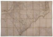 MOUZON - AN ACCURATE MAP OF NORTH AND SO
[more like this]
MOUZON - AN ACCURATE MAP OF NORTH AND SO
[more like this]
-
 SOCIETY OF MONTANA PIONEERS VOL. 1, 1899
[more like this]
SOCIETY OF MONTANA PIONEERS VOL. 1, 1899
[more like this]
This list is limited to only a few results.
Many more items are available to our members in our
Price Guide!
Ideal research tools for Collectors, Personal Property Appraisers, Antiques & Collectibles
Dealers, Auction Houses, Museums, eBayers or
other online
sellers (Rubylane, Etsy etc) and curious minds interested in appraising & identifying collectibles

EASY. FAST. ACCURATE.
Research at its best

Our research tools include:


