Pricing Guides & Dictionary of Makers Marks for Antiques & Collectibles
Appraise and find values for
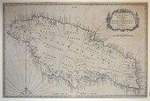
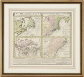
Two 19th c. maps of Jamaica each 36...
From
marks4antiques.com
- The most updated price guide and makers' marks research online
As a member, you have access to a team of experts
and assistance is always available to you for free
An example from the millions of items in our Price Guide:
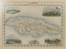
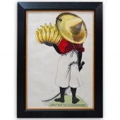
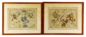
Two 19th c. maps of Jamaica each 36 x 25 cm a set of six hand coloured 18th century framed prints of London largest approx. 9 x 6.5cm an oil on board...
This is an example from our
values4antiques price guide
We do not buy or sell any items
See more price guides
Check our other research services:
IDENTIFY WORLDWIDE MAKERS' MARKS & HALLMARKS
marks4ceramics:
Porcelain, Pottery, Chinaware, Figurines, Dolls, Vases...
marks4silver
:
Silver, Jewelry, Pewter, Silverplate, Copper & Bronze...
Explore other items from our
Antiques & Collectibles Price Guide
-
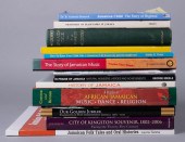 THIRTEEN BOOKS ON JAMAICATHIRTEEN BOOKS
[more like this]
THIRTEEN BOOKS ON JAMAICATHIRTEEN BOOKS
[more like this]
-
 A Very Large Collection of Maps, 19th/e
[more like this]
A Very Large Collection of Maps, 19th/e
[more like this]
-
 3 pieces. Engraved Maps - Jamaica: Moun
[more like this]
3 pieces. Engraved Maps - Jamaica: Moun
[more like this]
-
 2 FRAMED 18TH C. FADEN MAPS - GREECE & D
[more like this]
2 FRAMED 18TH C. FADEN MAPS - GREECE & D
[more like this]
-
 DU HALDE, Jean-Baptiste, (French, 1674-1
[more like this]
DU HALDE, Jean-Baptiste, (French, 1674-1
[more like this]
-
 4 vols. (Pennsylvania Property Atlases
[more like this]
4 vols. (Pennsylvania Property Atlases
[more like this]
-
 1 vol. (Philadelphia Atlas.) Smedley, S
[more like this]
1 vol. (Philadelphia Atlas.) Smedley, S
[more like this]
-
 MITCHELL. A NEW UNIVERSAL ATLAS CONTAINI
[more like this]
MITCHELL. A NEW UNIVERSAL ATLAS CONTAINI
[more like this]
-
 HENRY MOUZON - MAP OF NORTH AND SOUTH CA
[more like this]
HENRY MOUZON - MAP OF NORTH AND SOUTH CA
[more like this]
-
 AN ANTIQUE MAP, "CARTE DES VARIATIONS DE
[more like this]
AN ANTIQUE MAP, "CARTE DES VARIATIONS DE
[more like this]
-
 8 TENNESSEE MILITARY & SURVEY MAPSAssort
[more like this]
8 TENNESSEE MILITARY & SURVEY MAPSAssort
[more like this]
-
 6 MISSISSIPPI AND TENNESSEE RIVER MAPSSi
[more like this]
6 MISSISSIPPI AND TENNESSEE RIVER MAPSSi
[more like this]
-
 5 CIVIL WAR MAPSLot of five Civil War ma
[more like this]
5 CIVIL WAR MAPSLot of five Civil War ma
[more like this]
-
 A Large Collection of Maps of America,
[more like this]
A Large Collection of Maps of America,
[more like this]
-
 5 CIVIL WAR RELATED BOOKS1st item: Hopki
[more like this]
5 CIVIL WAR RELATED BOOKS1st item: Hopki
[more like this]
-
 2 vols. (Philadelphia Property Atlases.
[more like this]
2 vols. (Philadelphia Property Atlases.
[more like this]
-
 7 vols. Cartography: Brown, Lloyd A. Th
[more like this]
7 vols. Cartography: Brown, Lloyd A. Th
[more like this]
-
 7 vols. Cartography - American Subjects
[more like this]
7 vols. Cartography - American Subjects
[more like this]
-
 1782 Thomas Kitchen atlas, A General Atl
[more like this]
1782 Thomas Kitchen atlas, A General Atl
[more like this]
-
 Military Maps Illustrating the Operation
[more like this]
Military Maps Illustrating the Operation
[more like this]
-
 THE LIFE OF GEORGE WASHINGTON, BY JOHN M
[more like this]
THE LIFE OF GEORGE WASHINGTON, BY JOHN M
[more like this]
-
 MAPS: JOHN SPEED (ENGLAND, 1552-1629), T
[more like this]
MAPS: JOHN SPEED (ENGLAND, 1552-1629), T
[more like this]
-
 MAPS: JOHN MARSHALL "THE LIFE OF GEORGE
[more like this]
MAPS: JOHN MARSHALL "THE LIFE OF GEORGE
[more like this]
-
 (5) TEXAS MAPS, 1850'S<br>(lot of 5
[more like this]
(5) TEXAS MAPS, 1850'S<br>(lot of 5
[more like this]
-
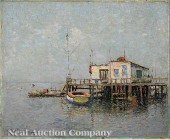 Paul Sawyier (American/Kentucky 1865-191
[more like this]
Paul Sawyier (American/Kentucky 1865-191
[more like this]
-
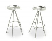 PEPE CORTES (B.1946), TWO ALUMINUM "JAMA
[more like this]
PEPE CORTES (B.1946), TWO ALUMINUM "JAMA
[more like this]
-
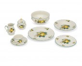 A VILLEROY & BOCH "JAMAICA" PORCELAIN DI
[more like this]
A VILLEROY & BOCH "JAMAICA" PORCELAIN DI
[more like this]
-
 KEITH MORRISON O/C, IN THE WOODSKeith An
[more like this]
KEITH MORRISON O/C, IN THE WOODSKeith An
[more like this]
-
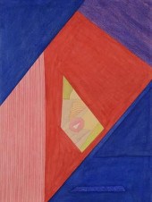 KEITH MORRISON ABSTRACT WATERCOLORKeith
[more like this]
KEITH MORRISON ABSTRACT WATERCOLORKeith
[more like this]
-
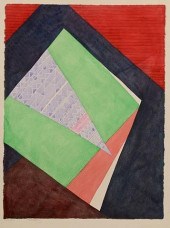 KEITH MORRISON ABSTRACT, JANKUNUKeith An
[more like this]
KEITH MORRISON ABSTRACT, JANKUNUKeith An
[more like this]
-
 VINTAGE JAMAICA ADVERTISING POSTERDESCRI
[more like this]
VINTAGE JAMAICA ADVERTISING POSTERDESCRI
[more like this]
-
 MAPS: TWO HAND-COLORED CELESTIAL MAPS, L
[more like this]
MAPS: TWO HAND-COLORED CELESTIAL MAPS, L
[more like this]
-
 TWO ANTIQUE ANTEBELLUM MAPS, "MAP OF TEX
[more like this]
TWO ANTIQUE ANTEBELLUM MAPS, "MAP OF TEX
[more like this]
-
 A LATE MEXICAN-AMERICAN WAR ERA MAP, "MA
[more like this]
A LATE MEXICAN-AMERICAN WAR ERA MAP, "MA
[more like this]
-
 SOCIETY OF MONTANA PIONEERS VOL. 1, 1899
[more like this]
SOCIETY OF MONTANA PIONEERS VOL. 1, 1899
[more like this]
-
 HOMANN MAP, BRITISH TERRITORIES IN NORTH
[more like this]
HOMANN MAP, BRITISH TERRITORIES IN NORTH
[more like this]
This list is limited to only a few results.
Many more items are available to our members in our
Price Guide!
Ideal research tools for Collectors, Personal Property Appraisers, Antiques & Collectibles
Dealers, Auction Houses, Museums, eBayers or
other online
sellers (Rubylane, Etsy etc) and curious minds interested in appraising & identifying collectibles

EASY. FAST. ACCURATE.
Research at its best

Our research tools include:


