Pricing Guides & Dictionary of Makers Marks for Antiques & Collectibles
A few examples of appraisal values for
HERMAN MOLL
Search our price guide for your own treasures
-
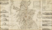 HERMAN MOLL, MAP OF SCOTLAND,
 1714Property of a Private Collection, Savannah, GA (British, 1654?-1732), The North Part of Great Britain Called Scotland, 1714, engraved map with outline color, matted and framed. Frame size: 32 1/2 in.
HERMAN MOLL, MAP OF SCOTLAND,
HERMAN MOLL, MAP OF SCOTLAND, 1714Property of a Private Collection, Savannah, GA (British, 1654?-1732), The North Part of Great Britain Called Scotland, 1714, engraved map with outline color, matted and framed. Frame size: 32 1/2 in. -
 HERMAN MOLL 18TH C. MAP OF ASIA.
 Engraved and hand colored “Map of Asia According to the Newest and Most Exact Observations”, London, C 1730: H. Moll (1654-1732), J. Bowles, T. Bowles, P. Overton, and J. King. Two joined sheets of paper. Dedication to William, Lord Cowper in cartouche lower left. Image sight size 22.75”H x 37.75”W, Overall in gold frame 23.5”H x 38.5 W.
HERMAN MOLL 18TH C. MAP OF ASIA.
HERMAN MOLL 18TH C. MAP OF ASIA. Engraved and hand colored “Map of Asia According to the Newest and Most Exact Observations”, London, C 1730: H. Moll (1654-1732), J. Bowles, T. Bowles, P. Overton, and J. King. Two joined sheets of paper. Dedication to William, Lord Cowper in cartouche lower left. Image sight size 22.75”H x 37.75”W, Overall in gold frame 23.5”H x 38.5 W. -
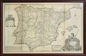 MAP, HERMAN MOLL Herman Moll
 (German, 1654-1732), "A New and Exact Map of Spain and Portugal Divided into its Kingdoms and Principalities," 1711, copper engraved map, exact printing date unknown, overall (with frame): 27"h x 42"w
MAP, HERMAN MOLL Herman Moll
MAP, HERMAN MOLL Herman Moll (German, 1654-1732), "A New and Exact Map of Spain and Portugal Divided into its Kingdoms and Principalities," 1711, copper engraved map, exact printing date unknown, overall (with frame): 27"h x 42"w -
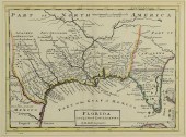 18TH C. FLORIDA MAP - HERMAN
 MOLLFLORIDA, CALLED BY YE FRENCH LOUISIANA & C., hand colored engraved map by Herman Moll (1688-1732), originally appeared in Moll's Atlas Minor (1736). 8 1/8" x 11" plate, 8 3/8" x 11 1/8" sight, 15" x 11" matted in new ebonized bamboo style frame. Significant early Southern map, includes Natchez, but not New Orleans, and many Indian roads and villages in Texas, French forts along the Mississippi Valley, and other good details. (Higher-resolution photos are available at www.caseantiques.com) Condition: Excellent condition, possibly de-acidified. Full margins appear to be present. Map taped at margin corners.
18TH C. FLORIDA MAP - HERMAN
18TH C. FLORIDA MAP - HERMAN MOLLFLORIDA, CALLED BY YE FRENCH LOUISIANA & C., hand colored engraved map by Herman Moll (1688-1732), originally appeared in Moll's Atlas Minor (1736). 8 1/8" x 11" plate, 8 3/8" x 11 1/8" sight, 15" x 11" matted in new ebonized bamboo style frame. Significant early Southern map, includes Natchez, but not New Orleans, and many Indian roads and villages in Texas, French forts along the Mississippi Valley, and other good details. (Higher-resolution photos are available at www.caseantiques.com) Condition: Excellent condition, possibly de-acidified. Full margins appear to be present. Map taped at margin corners. -
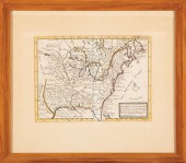
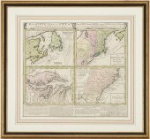 HOMANN MAP, BRITISH TERRITORIES
 IN NORTH AMERICA, C. 17...DOMINICA ANGLORUM IN AMERICA SEPTENTRIONALIS map, published by the Heirs of Johann Baptist Homann after Herman Moll, Nuremberg, ca. 1737-40. Copperplate engraving with hand-coloring depicting the British territories of North America, divided into four smaller inset maps, titled: "Newfoundland od Terra Nova S. Laurentii Bay", "New Engelland New York New Yersey und Pensilvania", "Virginia und Maryland", and "Carolina nebsteinem Theil von Florida". Each map depicts cities and towns, including Boston, Richmond, and Charlestown; rivers and other bodies of water; mountains; forts; and other points of interest including Native American tribe locations, with Latin, English, and German text. Titled, across top above maps, with individual titles and scale of miles for each map, additional text and tables, across bottom below maps. Maps surrounded by scale notations. Housed under glass and matted in a giltwood frame with ebonized trim. Image: 19 3/4" H x 22" W. Sight: 20 1/4" H x 22 3/8" W. Framed: 29" H x 31 1/4" W. The Collection of Dr. Joe Newsom Rawlings, Davisboro, Georgia. Condition: Overall very good condition with scattered foxing spots, staining, largest 2" x 3/4". 1" tear to bottom of center fold line. Not examined outside of frame. Frame with minor abrasions.
HOMANN MAP, BRITISH TERRITORIES
HOMANN MAP, BRITISH TERRITORIES IN NORTH AMERICA, C. 17...DOMINICA ANGLORUM IN AMERICA SEPTENTRIONALIS map, published by the Heirs of Johann Baptist Homann after Herman Moll, Nuremberg, ca. 1737-40. Copperplate engraving with hand-coloring depicting the British territories of North America, divided into four smaller inset maps, titled: "Newfoundland od Terra Nova S. Laurentii Bay", "New Engelland New York New Yersey und Pensilvania", "Virginia und Maryland", and "Carolina nebsteinem Theil von Florida". Each map depicts cities and towns, including Boston, Richmond, and Charlestown; rivers and other bodies of water; mountains; forts; and other points of interest including Native American tribe locations, with Latin, English, and German text. Titled, across top above maps, with individual titles and scale of miles for each map, additional text and tables, across bottom below maps. Maps surrounded by scale notations. Housed under glass and matted in a giltwood frame with ebonized trim. Image: 19 3/4" H x 22" W. Sight: 20 1/4" H x 22 3/8" W. Framed: 29" H x 31 1/4" W. The Collection of Dr. Joe Newsom Rawlings, Davisboro, Georgia. Condition: Overall very good condition with scattered foxing spots, staining, largest 2" x 3/4". 1" tear to bottom of center fold line. Not examined outside of frame. Frame with minor abrasions. -
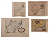 FOUR 17TH AND 18TH CENTURY MAPS
 OF THE SOUTHEASTengravings on laid paper, some with hand colored highlights, all unframed, including: Jacques-Nicolas Bellin (1703-1772), Carte De La Caroline et Georgie... , Paris, circa 1757, plate 8 x 11-3/4 in., sheet 10-1/8 x 15 in.; J. Denison, Map of North and South Carolina , engraver Amos Doolittle, Boston, 1796, for Morse's Universal Geography , sheet 8-1/2 x 10-5/8 in.; Herman Moll (circa 1654-1732), Carolina , London, circa 1708, from John Oldmixon's The British Empire in America , sheet 8-1/4 x 7-1/4 in.; Jodocus Hondius (1563-1612), Virginia et Florida , Amsterdam, circa 1635, published in Historia Mundi: or Mercator's Atlas , sheet approximately 7 x 9 in. Provenance: Humber Family, North Carolina Condition: all with some toning and light staining throughout, light wear to edges; Denison map moderately toned, some offsetting to right side; Hondius map laid down on board, some losses to sheet
FOUR 17TH AND 18TH CENTURY MAPS
FOUR 17TH AND 18TH CENTURY MAPS OF THE SOUTHEASTengravings on laid paper, some with hand colored highlights, all unframed, including: Jacques-Nicolas Bellin (1703-1772), Carte De La Caroline et Georgie... , Paris, circa 1757, plate 8 x 11-3/4 in., sheet 10-1/8 x 15 in.; J. Denison, Map of North and South Carolina , engraver Amos Doolittle, Boston, 1796, for Morse's Universal Geography , sheet 8-1/2 x 10-5/8 in.; Herman Moll (circa 1654-1732), Carolina , London, circa 1708, from John Oldmixon's The British Empire in America , sheet 8-1/4 x 7-1/4 in.; Jodocus Hondius (1563-1612), Virginia et Florida , Amsterdam, circa 1635, published in Historia Mundi: or Mercator's Atlas , sheet approximately 7 x 9 in. Provenance: Humber Family, North Carolina Condition: all with some toning and light staining throughout, light wear to edges; Denison map moderately toned, some offsetting to right side; Hondius map laid down on board, some losses to sheet -
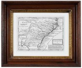 MOLL - MAP OF CAROLINAHerman
 Moll, Carolina , London, circa 1720, engraving on laid paper, plate 8-1/8 x 11 in., sheet 10 x 11-7/8 in.; carved and gilt wood frame, 15 x 18 in. Provenance: Private South Carolina Collection Condition: held under mat by corner tabs, good overall, minor creasing; frame with light wear and abrasions
MOLL - MAP OF CAROLINAHerman
MOLL - MAP OF CAROLINAHerman Moll, Carolina , London, circa 1720, engraving on laid paper, plate 8-1/8 x 11 in., sheet 10 x 11-7/8 in.; carved and gilt wood frame, 15 x 18 in. Provenance: Private South Carolina Collection Condition: held under mat by corner tabs, good overall, minor creasing; frame with light wear and abrasions -
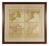 HOMANN HEIRS, BRITISH COLONIES MAP,
 1745Homann Heirs (German, 1702-1848), Dominia Anglorum in America Septentrionali Specialibus Mappis Londini primum a Mollio..., 4 maps. New England; Chesapeake; Carolinas & Florida; Nova Scotia, from Atlas Geographicus Maior, Nuremberg, 1745, Herman Moll (1688-1745), engraver, hand colored. Overall framed size is 29" x 31". Good condition and nicely framed with some wear including closed tears and discolorations. shipping info This item will need to be shipped by a packing company of your choice. We maintain a list of reliable shippers, or you may choose your own.
HOMANN HEIRS, BRITISH COLONIES MAP,
HOMANN HEIRS, BRITISH COLONIES MAP, 1745Homann Heirs (German, 1702-1848), Dominia Anglorum in America Septentrionali Specialibus Mappis Londini primum a Mollio..., 4 maps. New England; Chesapeake; Carolinas & Florida; Nova Scotia, from Atlas Geographicus Maior, Nuremberg, 1745, Herman Moll (1688-1745), engraver, hand colored. Overall framed size is 29" x 31". Good condition and nicely framed with some wear including closed tears and discolorations. shipping info This item will need to be shipped by a packing company of your choice. We maintain a list of reliable shippers, or you may choose your own. -
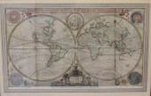
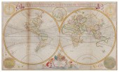 HERMAN MOLL; AND THOMAS BOWLES
 AND SONS (1654-1732, BRITISH); AND (17TH/18TH CENTURY, BRITISH)Herman Moll; and Thomas Bowles and Sons (1654-1732, British); and (17th/18th Century, British), "A New and Correct Map of the World Laid Down According to the Newest Discoveries and from the Most Exact Observations," circa 1720 Engraving with hand-coloring on two joined sheets, as issued From the edition of unknown size and date Sight: 22.75" H x 38.5" W Provenance: Lahaina Printsellers Ltd., Maui, HI Notes: This lot is accompanied by a certificate of authenticity, as well as a copy of an invoice, dated July 7, 1994, from Lahaina Printsellers Ltd., Maui, HI. Provenance: Lahaina Printsellers Ltd., Maui, HI
HERMAN MOLL; AND THOMAS BOWLES
HERMAN MOLL; AND THOMAS BOWLES AND SONS (1654-1732, BRITISH); AND (17TH/18TH CENTURY, BRITISH)Herman Moll; and Thomas Bowles and Sons (1654-1732, British); and (17th/18th Century, British), "A New and Correct Map of the World Laid Down According to the Newest Discoveries and from the Most Exact Observations," circa 1720 Engraving with hand-coloring on two joined sheets, as issued From the edition of unknown size and date Sight: 22.75" H x 38.5" W Provenance: Lahaina Printsellers Ltd., Maui, HI Notes: This lot is accompanied by a certificate of authenticity, as well as a copy of an invoice, dated July 7, 1994, from Lahaina Printsellers Ltd., Maui, HI. Provenance: Lahaina Printsellers Ltd., Maui, HI -
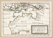 HERMAN MOLL, ENGLISH 1650?-1732,
 NEW GUINEA, NEW BRITAIN, AND NEW HOLLAND..., 1717, HAND COLORED ENGRAVING, FRAME: 8 3/4 X 10 3/4 X 10 3/4 IN. (22.2 X 27.3 X 27.3 CM.)HERMAN MOLL, ENGLISH, 1650?-1732 NEW GUINEA, NEW BRITAIN, AND NEW HOLLAND..., 1717, Hand colored engraving Printed for Carington Bowles, London; partial coloring Hand colored engraving Dimensions: Frame: 8 3/4 x 10 3/4 x 10 3/4 in. (22.2 x 27.3 x 27.3 cm.) Provenance: Private Maryland and Massachusetts Estate Collection
HERMAN MOLL, ENGLISH 1650?-1732,
HERMAN MOLL, ENGLISH 1650?-1732, NEW GUINEA, NEW BRITAIN, AND NEW HOLLAND..., 1717, HAND COLORED ENGRAVING, FRAME: 8 3/4 X 10 3/4 X 10 3/4 IN. (22.2 X 27.3 X 27.3 CM.)HERMAN MOLL, ENGLISH, 1650?-1732 NEW GUINEA, NEW BRITAIN, AND NEW HOLLAND..., 1717, Hand colored engraving Printed for Carington Bowles, London; partial coloring Hand colored engraving Dimensions: Frame: 8 3/4 x 10 3/4 x 10 3/4 in. (22.2 x 27.3 x 27.3 cm.) Provenance: Private Maryland and Massachusetts Estate Collection -
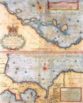 WILLIAM HACKE AND ROBERT MORDEN,
 17TH C. MAP PROMOTING SCOTLAND’S “DARIEN SCHEME” IN PANAMA, RARE FIRST EDITION, 1699, TWO ENGRAVED...William Hacke and Robert Morden, 17th C. map promoting Scotland's "Darien Scheme" in Panama, rare first edition, 1699, two engraved maps on one sheet, "A Draft of the Golden & Adjacent Islands, with Part of ye Isthmus of Darien..." and "A New Map of ye Isthmus of Darien in America, the Bay of Panama, the Gulph of Vallona or St. Michael...", by William Hacke and Robert Morden, engraved by Herman Moll, published by John Senex, hand-colored, the upper map depicts the north coast of Panama with part of the San Blas Islands and features the short-lived colony of New Edinburgh, The Company of Scotland established this ill-fated trading settlement on the Darien coast of Panama in 1698, but despite being well located within a year the colony failed due to illness and attack by Spanish galleons, the failure of the Darien Scheme contributed greatly to the crippling of the entire Scottish economy that eventually led to the dissolution of the Scottish Parliament and the 1707 Act of Union with England, the lower map shows the whole isthmus of Panama with part of Costa Rica and Colombia, both maps were finely engraved with rhumb lines, compass roses, sailing ships, soundings and decorative cartouches, nicely framed and matted behind glass, wear consistent with age and use including tears, repairs, creasing, scuffs, pin-sized holes, toning, etc., sold as found, frame size: 30" h. x 26" w.
WILLIAM HACKE AND ROBERT MORDEN,
WILLIAM HACKE AND ROBERT MORDEN, 17TH C. MAP PROMOTING SCOTLAND’S “DARIEN SCHEME” IN PANAMA, RARE FIRST EDITION, 1699, TWO ENGRAVED...William Hacke and Robert Morden, 17th C. map promoting Scotland's "Darien Scheme" in Panama, rare first edition, 1699, two engraved maps on one sheet, "A Draft of the Golden & Adjacent Islands, with Part of ye Isthmus of Darien..." and "A New Map of ye Isthmus of Darien in America, the Bay of Panama, the Gulph of Vallona or St. Michael...", by William Hacke and Robert Morden, engraved by Herman Moll, published by John Senex, hand-colored, the upper map depicts the north coast of Panama with part of the San Blas Islands and features the short-lived colony of New Edinburgh, The Company of Scotland established this ill-fated trading settlement on the Darien coast of Panama in 1698, but despite being well located within a year the colony failed due to illness and attack by Spanish galleons, the failure of the Darien Scheme contributed greatly to the crippling of the entire Scottish economy that eventually led to the dissolution of the Scottish Parliament and the 1707 Act of Union with England, the lower map shows the whole isthmus of Panama with part of Costa Rica and Colombia, both maps were finely engraved with rhumb lines, compass roses, sailing ships, soundings and decorative cartouches, nicely framed and matted behind glass, wear consistent with age and use including tears, repairs, creasing, scuffs, pin-sized holes, toning, etc., sold as found, frame size: 30" h. x 26" w. -
 TWO HAND-COLORED MAPSTwo
 Hand-Colored Maps , incl. "Typus Orbis Terrarum", c. 1601, from Abraham Orelius' miniature atlas, 3 in. x 4 1/4 in.; and "A New Map of ye North Parts of America claimed by France...", 1729, from Herman Moll's Atlas Minor, 8 in. x 10 3/4 in., both framed
TWO HAND-COLORED MAPSTwo
TWO HAND-COLORED MAPSTwo Hand-Colored Maps , incl. "Typus Orbis Terrarum", c. 1601, from Abraham Orelius' miniature atlas, 3 in. x 4 1/4 in.; and "A New Map of ye North Parts of America claimed by France...", 1729, from Herman Moll's Atlas Minor, 8 in. x 10 3/4 in., both framed -
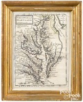 HERMAN MOLL COLOR ENGRAVED
 MAPHerman Moll color engraved map of Virginia and Maryland , 11" x 8". Provenance: A Richmond, Virginia collection. Condition: Edges trimmed. Not laid down. 11 3/4" x 8 1/2". Minor toning and foxing. Crack to corner of glass. Professionally conserved.
HERMAN MOLL COLOR ENGRAVED
HERMAN MOLL COLOR ENGRAVED MAPHerman Moll color engraved map of Virginia and Maryland , 11" x 8". Provenance: A Richmond, Virginia collection. Condition: Edges trimmed. Not laid down. 11 3/4" x 8 1/2". Minor toning and foxing. Crack to corner of glass. Professionally conserved. -
 Hand Colored Map by Herman Moll.
 ''A New andCorrect Map of the World Laid Down According to the Newest Discoveries and From the Most Exact Observations.'' Printed by I. Bowles and T. Bowles. With dedication to King George II. From a Larchmont NY estate. Dimensions: sight - 22.75'' high x 38.25'' wide. Condition: Foxing throughout and vertical creases through left right and center of sheet. Appears to be in delicate condition with tear and loss to top left corner and tear at top right corner. Some tearing along crease marks. Possibly laid on linen. Please note that we are not bibliophiles or cartographers and cannot provide that level of detail.
Hand Colored Map by Herman Moll.
Hand Colored Map by Herman Moll. ''A New andCorrect Map of the World Laid Down According to the Newest Discoveries and From the Most Exact Observations.'' Printed by I. Bowles and T. Bowles. With dedication to King George II. From a Larchmont NY estate. Dimensions: sight - 22.75'' high x 38.25'' wide. Condition: Foxing throughout and vertical creases through left right and center of sheet. Appears to be in delicate condition with tear and loss to top left corner and tear at top right corner. Some tearing along crease marks. Possibly laid on linen. Please note that we are not bibliophiles or cartographers and cannot provide that level of detail. -
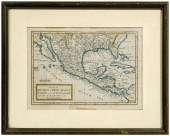 18th century map, North America,
 Mexico, "A Map of Mexico or New Spain Florida now called Louisiana and Part of California & c." by Herman Moll, from Atlas Geographus: or; A Compleat System of Geography, (Ancient and Modern) For America , published by John Nicholson, circa 1720, hand colored copper engraving on laid paper, 8 x 9 in. (page); modern wood frame. Laid down on acidic card, toning, minor foxing, tape residue, creases, pencil inscription "1715" lower right. Private Collection, Cashiers, North Carolina
18th century map, North America,
18th century map, North America, Mexico, "A Map of Mexico or New Spain Florida now called Louisiana and Part of California & c." by Herman Moll, from Atlas Geographus: or; A Compleat System of Geography, (Ancient and Modern) For America , published by John Nicholson, circa 1720, hand colored copper engraving on laid paper, 8 x 9 in. (page); modern wood frame. Laid down on acidic card, toning, minor foxing, tape residue, creases, pencil inscription "1715" lower right. Private Collection, Cashiers, North Carolina -
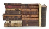 Rare books: Ottoman Empire
 history and reference Edrehi Isaac HISTORY OF THE CAPITAL OF ASIA AND THE TURKS TOGETHER WITH AN ACCOUNT OF THE DOMESTIC MANNERS OF THE TURKS IN TURKEY. Vol I-III in one. Boston: Isaac Edrehi 1855. With six lithographs; Savary Claude Etienne. LETTERS ON GREECE BEING THE SEQUEL OF LETTERS ON EGYPT. London: C. Elliot 1788. With one folding map and folding engraving; Habesci Elias. THE PRESENT STATE OF THE OTTOMAN EMPIRE. London: R. Baldwin 1784; Alexander James Edward TRAVELS TO THE SEAT OF THE WAR IN THE EAST. Vol I-II. London: Henry Colburn 1830; Maundrell Henry. A JOURNEY FROM JERUSALEM AT EASTER A.D. 1697. London: J. White and Co. 1810; Carne John. SYRIA THE HOLY LAND ASIA MINOR. London: Fisher and Son 1836. Three volumes bound as one; Ashton John THE VOYAGE AND TRAVAYLE OF SIR JOHN MAUNDEVILLE KNIGHT. London: Pickering & Chatto 1887; Eton W. A SURVEY OF THE TURKISH EMPIRE. London: T. Cadell 1799; Salmon Thomas. Modern history: or the present state of all nations. Illustrated with cuts and Maps by Herman Moll. Vol. IV. London: James Crokatt 1726. With three folding maps and folding illustration of Jerusalem various other engravings throughout; Finlay George. HISTORY OF THE BYZANTINE AND GREEK EMPIRES. 2 Vols. Edinburgh and London: William Blackwood and sons 1854; and six similar titles. (20pcs) Provenance: Estate of Michael M. Finefrock Charleston South Carolina. HISTORY OF THE CAPITAL OF ASIA: deterioration to spine; covers with losses to corners; front section with waterstains; back section with tears to paper; gilding intact. LETTERS ON GREECE: deterioration to binding spine loose; age discoloration and foxing throughout. THE PRESENT STATE OF THE OTTOMAN EMPIRE: new bindings in good condition; pages lightly toned. TRAVELS TO THE SEAT OF THE WAR: spines loosening bindings with wear; pages with age discoloration. Carne. SYRIA THE HOLY LAND ASIA MINOR 1836: bindings heavily worn; pages with foxing toning and age discoloration. Ashton John. THE VOYAGE AND TRAVAYLE OF SIR JOHN MAUNDEVILLE KNIGHT. 1887: bindings worn; pages in good condition. Finlay. HISTORY OF THE BYZANTINE AND GREEK EMPIRES. Vols. I-II. 1854: Vol. I with covers 3/4 detached; both with bindings worn; pages toned; marbled edges; vol. II pages tight. Eton W. A SURVEY OF THE TURKISH EMPIRE. 1799: new bindings tight; pages in good condition. Maundrell Henry. A JOURNEY FROM APPO TO JERUSALEM. 1810: bindings worn and spine beginning to detach; pages with foxing and age discoloration. Beaufort Francis. MEMOIR OF A SURVEY OF THE COAST OF KARAMANIA. 1820: bindings worn spine damaged; pages with foxing and staining throughout. Porter. OBSERVATIONS ON THE RELIGION LAW GOVERNMENT AND MANNERS OF THE TURKS. 1771: pages toned some torn; bindings tight. Baron von Valentini. MILITARY REFLECTIONS ON TURKEY. 1828: bindings worn with frayed edges; pages mostly in good condition; endpage torn; foxing to folded map. THE LIFE OF CATHARINE II. Vols. I-III. London: 1799: spines deteriorated; front pages foxed and discolored; all other pages toned; bindings are tight. Vandal Albert. UNE AMBASSADE FRANCAISE EN ORIENT SOUS LOUIS XV. 1887: some age discoloration; wear and rubbing to spine; covers okay; pages tight. Mr. Salmon. MODERN HISTORY OR THE PRESENT STATE OF ALL NATIONS. Vol. IV. 1726: spine worn; some foxing; some slight damage along creases on folded maps. Voltaire. THE HISTORY OF THE WAR OF SEVENTEEN HUNDRED AND FORTY ONE. London: 1756: spine deteriorated; front cover nearly detached; pages toned. Back   Inquiry    Previous Item  Next Item © Charlton Hall Auctions. Images descriptions and condition reports used on this site are original copyright material and are not to be reproduced without permission. For further information telephone 803.779.5678   © 2012 CHARLTON HALL GALLERIES INC.
Rare books: Ottoman Empire
Rare books: Ottoman Empire history and reference Edrehi Isaac HISTORY OF THE CAPITAL OF ASIA AND THE TURKS TOGETHER WITH AN ACCOUNT OF THE DOMESTIC MANNERS OF THE TURKS IN TURKEY. Vol I-III in one. Boston: Isaac Edrehi 1855. With six lithographs; Savary Claude Etienne. LETTERS ON GREECE BEING THE SEQUEL OF LETTERS ON EGYPT. London: C. Elliot 1788. With one folding map and folding engraving; Habesci Elias. THE PRESENT STATE OF THE OTTOMAN EMPIRE. London: R. Baldwin 1784; Alexander James Edward TRAVELS TO THE SEAT OF THE WAR IN THE EAST. Vol I-II. London: Henry Colburn 1830; Maundrell Henry. A JOURNEY FROM JERUSALEM AT EASTER A.D. 1697. London: J. White and Co. 1810; Carne John. SYRIA THE HOLY LAND ASIA MINOR. London: Fisher and Son 1836. Three volumes bound as one; Ashton John THE VOYAGE AND TRAVAYLE OF SIR JOHN MAUNDEVILLE KNIGHT. London: Pickering & Chatto 1887; Eton W. A SURVEY OF THE TURKISH EMPIRE. London: T. Cadell 1799; Salmon Thomas. Modern history: or the present state of all nations. Illustrated with cuts and Maps by Herman Moll. Vol. IV. London: James Crokatt 1726. With three folding maps and folding illustration of Jerusalem various other engravings throughout; Finlay George. HISTORY OF THE BYZANTINE AND GREEK EMPIRES. 2 Vols. Edinburgh and London: William Blackwood and sons 1854; and six similar titles. (20pcs) Provenance: Estate of Michael M. Finefrock Charleston South Carolina. HISTORY OF THE CAPITAL OF ASIA: deterioration to spine; covers with losses to corners; front section with waterstains; back section with tears to paper; gilding intact. LETTERS ON GREECE: deterioration to binding spine loose; age discoloration and foxing throughout. THE PRESENT STATE OF THE OTTOMAN EMPIRE: new bindings in good condition; pages lightly toned. TRAVELS TO THE SEAT OF THE WAR: spines loosening bindings with wear; pages with age discoloration. Carne. SYRIA THE HOLY LAND ASIA MINOR 1836: bindings heavily worn; pages with foxing toning and age discoloration. Ashton John. THE VOYAGE AND TRAVAYLE OF SIR JOHN MAUNDEVILLE KNIGHT. 1887: bindings worn; pages in good condition. Finlay. HISTORY OF THE BYZANTINE AND GREEK EMPIRES. Vols. I-II. 1854: Vol. I with covers 3/4 detached; both with bindings worn; pages toned; marbled edges; vol. II pages tight. Eton W. A SURVEY OF THE TURKISH EMPIRE. 1799: new bindings tight; pages in good condition. Maundrell Henry. A JOURNEY FROM APPO TO JERUSALEM. 1810: bindings worn and spine beginning to detach; pages with foxing and age discoloration. Beaufort Francis. MEMOIR OF A SURVEY OF THE COAST OF KARAMANIA. 1820: bindings worn spine damaged; pages with foxing and staining throughout. Porter. OBSERVATIONS ON THE RELIGION LAW GOVERNMENT AND MANNERS OF THE TURKS. 1771: pages toned some torn; bindings tight. Baron von Valentini. MILITARY REFLECTIONS ON TURKEY. 1828: bindings worn with frayed edges; pages mostly in good condition; endpage torn; foxing to folded map. THE LIFE OF CATHARINE II. Vols. I-III. London: 1799: spines deteriorated; front pages foxed and discolored; all other pages toned; bindings are tight. Vandal Albert. UNE AMBASSADE FRANCAISE EN ORIENT SOUS LOUIS XV. 1887: some age discoloration; wear and rubbing to spine; covers okay; pages tight. Mr. Salmon. MODERN HISTORY OR THE PRESENT STATE OF ALL NATIONS. Vol. IV. 1726: spine worn; some foxing; some slight damage along creases on folded maps. Voltaire. THE HISTORY OF THE WAR OF SEVENTEEN HUNDRED AND FORTY ONE. London: 1756: spine deteriorated; front cover nearly detached; pages toned. Back   Inquiry    Previous Item  Next Item © Charlton Hall Auctions. Images descriptions and condition reports used on this site are original copyright material and are not to be reproduced without permission. For further information telephone 803.779.5678   © 2012 CHARLTON HALL GALLERIES INC. -
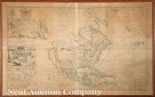 Herman Moll (Dutch/English
 1654-1732) "...Map of North America According to ye Newest and most Exact Observations..." c. 1719 London engraved copperplate map on two joined sheets in hand-colored outline showing California as an island large pictorial cartouche with American Indians and Eskimos ten inset maps showing harbors of New York Boston Havana etc. and a large vignette of "A View of a Stage & also of ye manner of Fishing for Curing & Drying Cod at New Foundland" 25 in. x 40 1/2 in.
Herman Moll (Dutch/English
Herman Moll (Dutch/English 1654-1732) "...Map of North America According to ye Newest and most Exact Observations..." c. 1719 London engraved copperplate map on two joined sheets in hand-colored outline showing California as an island large pictorial cartouche with American Indians and Eskimos ten inset maps showing harbors of New York Boston Havana etc. and a large vignette of "A View of a Stage & also of ye manner of Fishing for Curing & Drying Cod at New Foundland" 25 in. x 40 1/2 in. -
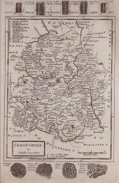 HERMAN MOLL (BRITISH 18TH
 CENTURY) SHROPSHIRE Engraving: 12 1/2 x 8 in. (sight) Framed
HERMAN MOLL (BRITISH 18TH
HERMAN MOLL (BRITISH 18TH CENTURY) SHROPSHIRE Engraving: 12 1/2 x 8 in. (sight) Framed -
 Eight 18th century maps dated by
 geographer Herman Moll of the East Indies, Sunda Islands, India, Celebes, China , North Pole, and Russia. Average size: 12" x 9". All maps have signs of foxing, mildew and water marks, some may have tears and holes. This lot is sold as-is.
Eight 18th century maps dated by
Eight 18th century maps dated by geographer Herman Moll of the East Indies, Sunda Islands, India, Celebes, China , North Pole, and Russia. Average size: 12" x 9". All maps have signs of foxing, mildew and water marks, some may have tears and holes. This lot is sold as-is.
...many more examples with full details are available to our members - Learn more
Easy & Visual methods to Identify & Appraise Antiques & Collectibles
EASY. FAST. ACCURATE.
Research at its best
We are here to help!
Our research tools include:

Thousands of makers marks for PORCELAIN, POTTERY CHINAWARE, FIGURINES, VASES
see details...

Thousands of marks & hallmarks for SILVER & JEWELRY, PEWTER, PRECIOUS METALS, SILVERPLATE
see details...
