Pricing Guides & Dictionary of Makers Marks for Antiques & Collectibles
A few examples of appraisal values for
VIRGIN ISLANDS
Search our price guide for your own treasures
-
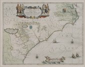
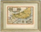
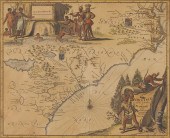
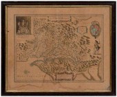
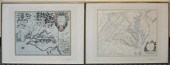
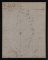 THE ISLAND OF ST. MARTIN
 Handcolored engraving. Together with two maps ''The Virgin Islands '' from English and Danish surveys by Thomas Jefferys published by Laurie and Whittle 1794 ''A New and Improved Chart of the West Indies or Carribean Islands '' drawn from the best authorities by William Heather 1795. Largest 33 1/2 x 27 1/4 in. (frame).
THE ISLAND OF ST. MARTIN
THE ISLAND OF ST. MARTIN Handcolored engraving. Together with two maps ''The Virgin Islands '' from English and Danish surveys by Thomas Jefferys published by Laurie and Whittle 1794 ''A New and Improved Chart of the West Indies or Carribean Islands '' drawn from the best authorities by William Heather 1795. Largest 33 1/2 x 27 1/4 in. (frame). -
 Socha Svender, 20th C West
 Indies, "St. Croix, Virgin Islands", watercolor on paper, signed "Socha 1955", 18-1/2" x 23-1/4" sight, framed 26" x 31", very good condition
Socha Svender, 20th C West
Socha Svender, 20th C West Indies, "St. Croix, Virgin Islands", watercolor on paper, signed "Socha 1955", 18-1/2" x 23-1/4" sight, framed 26" x 31", very good condition -
 Virginia/Tenn
Virginia/Tenn
Virginia/Tenn -
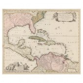
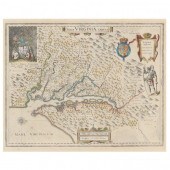
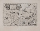
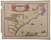
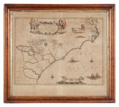
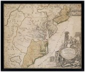
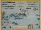 LAURIE & WHITTLE THE VIRGIN ISLANDS
 MAP LITHOGRAPH"The Virgin Islands from English and Danish Surveys" map. Published by Laurie and Whittle, London. Sight: 15 1/4" H x 20" W. Frame: 18 3/8" H x 24" W.
LAURIE & WHITTLE THE VIRGIN ISLANDS
LAURIE & WHITTLE THE VIRGIN ISLANDS MAP LITHOGRAPH"The Virgin Islands from English and Danish Surveys" map. Published by Laurie and Whittle, London. Sight: 15 1/4" H x 20" W. Frame: 18 3/8" H x 24" W. -
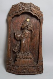 SPANISH COLONIAL WOOD AND IVORY
 RELIEF carved as the Virgin with an ivory-inlaid face and dressed in flowing robes on a flat ground with scrolling borders h:27 in.
SPANISH COLONIAL WOOD AND IVORY
SPANISH COLONIAL WOOD AND IVORY RELIEF carved as the Virgin with an ivory-inlaid face and dressed in flowing robes on a flat ground with scrolling borders h:27 in. -
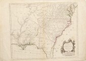
 17th Century Map of the Southeast
 "Virginiae partis australis, et Floridae partis orientalis...," by Willem Blaeu, after Mercator and Hondius, from Blaeu's Theatre du Monde ou Nouvel Atlas, Amsterdam, 1640, showing the coastline and interior from Chesapeake Bay to Northern Florida with coats-of-arms in interior representing English and French regional claims, elaborate hand-colored title cartouche with six Native Americans, scale vignette with two cherubs, Latin text verso, hand colored, on laid paper, 15-1/4 x 19-1/2 in.; in modern painted wood frame,
17th Century Map of the Southeast
17th Century Map of the Southeast "Virginiae partis australis, et Floridae partis orientalis...," by Willem Blaeu, after Mercator and Hondius, from Blaeu's Theatre du Monde ou Nouvel Atlas, Amsterdam, 1640, showing the coastline and interior from Chesapeake Bay to Northern Florida with coats-of-arms in interior representing English and French regional claims, elaborate hand-colored title cartouche with six Native Americans, scale vignette with two cherubs, Latin text verso, hand colored, on laid paper, 15-1/4 x 19-1/2 in.; in modern painted wood frame, -
 NICHOLAS VISSCHER, INSULAE
 AMERICANAE IN OCEANO SEPTENTRIONALI... ...ac Regiones Adjacentes, late 17th century, copperplate engraving with hand color, depicting the Caribbean and adjacent lands in North, South, and Central America; presented behind glass in mat within black wooden frame having a gilt liner.
NICHOLAS VISSCHER, INSULAE
NICHOLAS VISSCHER, INSULAE AMERICANAE IN OCEANO SEPTENTRIONALI... ...ac Regiones Adjacentes, late 17th century, copperplate engraving with hand color, depicting the Caribbean and adjacent lands in North, South, and Central America; presented behind glass in mat within black wooden frame having a gilt liner. -
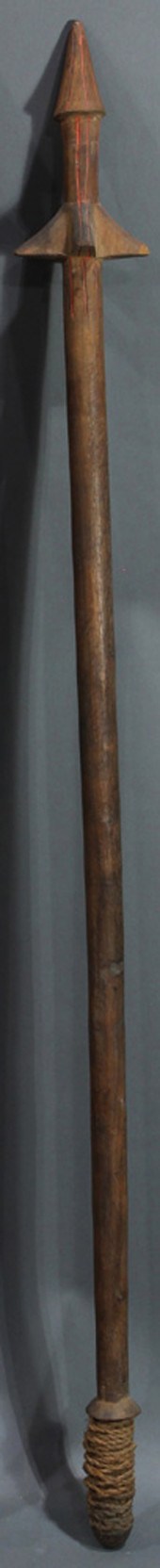 PENTECOST ISLAND, VANUATU, LONG
 THIN POLE CLUB WITH WRAP Pentecost Island, Vanuatu, circa early 20th century, long thin pole club with wrap, accented with bright orange pigment at the 4-barbed pointed end, 45"h; Provenance: Richard I.M. Kelton Collection, Marina del Rey, California
PENTECOST ISLAND, VANUATU, LONG
PENTECOST ISLAND, VANUATU, LONG THIN POLE CLUB WITH WRAP Pentecost Island, Vanuatu, circa early 20th century, long thin pole club with wrap, accented with bright orange pigment at the 4-barbed pointed end, 45"h; Provenance: Richard I.M. Kelton Collection, Marina del Rey, California -
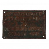 VIRGINIA BUSH BLIND LICENSE, SEASON
 1941 Knotts Island, Virginia, circa 1941, stamped and painted tin.
VIRGINIA BUSH BLIND LICENSE, SEASON
VIRGINIA BUSH BLIND LICENSE, SEASON 1941 Knotts Island, Virginia, circa 1941, stamped and painted tin. -
 VIRGINIA BERRESFORDMartha's
 Vineyard 1902-1995Irises in purples white and yellow. Executed with a broad-stroked palette knife on a stippled blue ground. Signed lower right Berresford''. Marked in pen verso ''West Tisbury Church Fair 1976''. Artist's biography from Vineyard Bookshelf newspaper attached to the reverse.Oil on board 20'' x 16''. Framed.''
VIRGINIA BERRESFORDMartha's
VIRGINIA BERRESFORDMartha's Vineyard 1902-1995Irises in purples white and yellow. Executed with a broad-stroked palette knife on a stippled blue ground. Signed lower right Berresford''. Marked in pen verso ''West Tisbury Church Fair 1976''. Artist's biography from Vineyard Bookshelf newspaper attached to the reverse.Oil on board 20'' x 16''. Framed.'' -
 BLAEU, WILLEM JANZOON. NOVA
 VIRGINIAE TABULA (Amsterdam, second half of 17th century), copperplate engraving with hand color; depicts the Chesapeake Bay region with mainland Virginia and Maryland beyond; of special interest is the interior view of King Powhatan's lodge in the upper left corner; the verso with Dutch text; the map presented behind glass in modern carved and painted wooden frame 24-1/4 x 28 in.; image 15-1/4 x 19-1/4 with full margins.
BLAEU, WILLEM JANZOON. NOVA
BLAEU, WILLEM JANZOON. NOVA VIRGINIAE TABULA (Amsterdam, second half of 17th century), copperplate engraving with hand color; depicts the Chesapeake Bay region with mainland Virginia and Maryland beyond; of special interest is the interior view of King Powhatan's lodge in the upper left corner; the verso with Dutch text; the map presented behind glass in modern carved and painted wooden frame 24-1/4 x 28 in.; image 15-1/4 x 19-1/4 with full margins. -
 17th century map of Virginia,
 Florida, from Mercator's Atlas sine Cosmographicae, published in France, circa 1630, double-page hand-colored map of the southeastern Atlantic seaboard titled Virginiae item et Floridas Americae Provinciarum, nova description by Jodocus Hondius, interpreted from earlier maps by John White and Jacques Le Moyne, engraving on laid paper with pages 367-368 from the atlas printed on map verso, 21-1/4 x 17-1/4 in.; modern wood frame. Toning, moisture stains, minor foxing, some coloring probably later, reinforced center crease, minor separations and tears, taped to glass in one place, pencil inscriptions verso.
17th century map of Virginia,
17th century map of Virginia, Florida, from Mercator's Atlas sine Cosmographicae, published in France, circa 1630, double-page hand-colored map of the southeastern Atlantic seaboard titled Virginiae item et Floridas Americae Provinciarum, nova description by Jodocus Hondius, interpreted from earlier maps by John White and Jacques Le Moyne, engraving on laid paper with pages 367-368 from the atlas printed on map verso, 21-1/4 x 17-1/4 in.; modern wood frame. Toning, moisture stains, minor foxing, some coloring probably later, reinforced center crease, minor separations and tears, taped to glass in one place, pencil inscriptions verso. -
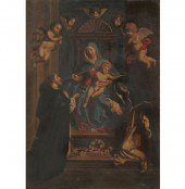
 SPANISH COLONIAL SCHOOL: VIRGIN AND
 CHILD WITH SAINTS Oil on wood depicted on a veil supported by God the Father and two other saints giltwood frame; 11 x 9 1/4 in.
SPANISH COLONIAL SCHOOL: VIRGIN AND
SPANISH COLONIAL SCHOOL: VIRGIN AND CHILD WITH SAINTS Oil on wood depicted on a veil supported by God the Father and two other saints giltwood frame; 11 x 9 1/4 in. -
 NATURE AND LOCATION PRINT OF ST.
 KITTS 18th century, depicting St. Christopher Island, West Indies.
NATURE AND LOCATION PRINT OF ST.
NATURE AND LOCATION PRINT OF ST. KITTS 18th century, depicting St. Christopher Island, West Indies. -
 Arnoldus Montanus Map of
 Southeastern Coast''Virginiae partis australis et Floridae partis orientalis...Nova Descriptio '' Amsterdam 1671 a hand-colored double-page copperplate engraving showing Virginia as an English possession and South Carolina as belonging to France. Sheet: 12 3/8 x 14 9/16 in.; Plate 11 3/8'' x 14 '' in. Presented behind mat in wooden frame.Sheet 12 3/8 xLightstruck showing mat's outline; even browning; colors vibrant; a few small marginal splits.
Arnoldus Montanus Map of
Arnoldus Montanus Map of Southeastern Coast''Virginiae partis australis et Floridae partis orientalis...Nova Descriptio '' Amsterdam 1671 a hand-colored double-page copperplate engraving showing Virginia as an English possession and South Carolina as belonging to France. Sheet: 12 3/8 x 14 9/16 in.; Plate 11 3/8'' x 14 '' in. Presented behind mat in wooden frame.Sheet 12 3/8 xLightstruck showing mat's outline; even browning; colors vibrant; a few small marginal splits. -
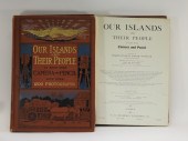 2 VOL. OUR ISLANDS & THEIR PEOPLE
 PHOTOGRAPH BOOKS United States,Circa 1899Two volume set including black and white and colored photographs of Hawaii and other Polynesian and Oceanic islands capturing native life.
2 VOL. OUR ISLANDS & THEIR PEOPLE
2 VOL. OUR ISLANDS & THEIR PEOPLE PHOTOGRAPH BOOKS United States,Circa 1899Two volume set including black and white and colored photographs of Hawaii and other Polynesian and Oceanic islands capturing native life. -
 Map of the Southeast After John
 White 17th century, "Viriginiae Item et Floridae Americae Provinciarum, Nove Descriptio," by Jodocus Hondius, after maps by John White and Jacques Le Moyne, published in Mercator's Atlas Novus, Sive Descriptio Geographic..., Amsterdam, circa 1630, showing the southeastern United States to northern Florida, elaborate title cartouche depicting Native American villages, other representations of Native Americans, wildlife, sea monsters and sailing ships, Latin text verso, strong dark impression, on laid paper, 13-1/2 x 19-1/4 in. (plate),
Map of the Southeast After John
Map of the Southeast After John White 17th century, "Viriginiae Item et Floridae Americae Provinciarum, Nove Descriptio," by Jodocus Hondius, after maps by John White and Jacques Le Moyne, published in Mercator's Atlas Novus, Sive Descriptio Geographic..., Amsterdam, circa 1630, showing the southeastern United States to northern Florida, elaborate title cartouche depicting Native American villages, other representations of Native Americans, wildlife, sea monsters and sailing ships, Latin text verso, strong dark impression, on laid paper, 13-1/2 x 19-1/4 in. (plate), -
 THE VIRGINIAN.The Virginian. New
 York: Metropolitan Printing Co., 1914. Color lithograph for the dramatization of Wister's classic Western starring silent film star Dustin Farnum, adapted by Wister together with Kirke La Shelle. 40 x 30 _". Linen-backed. Restored losses and over-painting in margins; repaired tears, creases, and abrasions along folds and in margins. B+.
THE VIRGINIAN.The Virginian. New
THE VIRGINIAN.The Virginian. New York: Metropolitan Printing Co., 1914. Color lithograph for the dramatization of Wister's classic Western starring silent film star Dustin Farnum, adapted by Wister together with Kirke La Shelle. 40 x 30 _". Linen-backed. Restored losses and over-painting in margins; repaired tears, creases, and abrasions along folds and in margins. B+. -
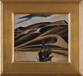 VIRGINIA TRUE (1900-1989): SAND
 DUNES Oil on board 14 x 16 in. c.1930 signed.
VIRGINIA TRUE (1900-1989): SAND
VIRGINIA TRUE (1900-1989): SAND DUNES Oil on board 14 x 16 in. c.1930 signed. -
 17th century map, Virginia, "Nova
 Virginiae Tabula", by Henricus Hondius, engraved after Jodocus Hondius' derivation of John White's 1612 map of Virginia, published by Henricus in L'Appendice de L'Atlas , Amsterdam,1633, intricately detailed map of the Chesapeake Bay and tributaries, Native American and English place names, Chief Powhatan and his subjects smoking tobacco depicted upper left, British Royal coat of arms and a Susquehanna Indian pictured on right, hand-colored engraving on laid paper, 18-3/4 x 22-3/4 in.; modern wood frame. Laid down on acidic card, toning, foxing, stains (affecting map), fading, tears and corner loss in margins; frame with abrasions. Estate of the Late Nathan and Mary Anne McCarley, Asheville, North Carolina.
17th century map, Virginia, "Nova
17th century map, Virginia, "Nova Virginiae Tabula", by Henricus Hondius, engraved after Jodocus Hondius' derivation of John White's 1612 map of Virginia, published by Henricus in L'Appendice de L'Atlas , Amsterdam,1633, intricately detailed map of the Chesapeake Bay and tributaries, Native American and English place names, Chief Powhatan and his subjects smoking tobacco depicted upper left, British Royal coat of arms and a Susquehanna Indian pictured on right, hand-colored engraving on laid paper, 18-3/4 x 22-3/4 in.; modern wood frame. Laid down on acidic card, toning, foxing, stains (affecting map), fading, tears and corner loss in margins; frame with abrasions. Estate of the Late Nathan and Mary Anne McCarley, Asheville, North Carolina. -
 BLAEU - VIRGINIAE PARTIS AUSTRALIS,
 ET FLORIDAE, MAPWillem Janszoon Blaeu (1571-1638), Virginiae Partis australis, et Floridae partis orientalis, interjacentiumqus regionum Nova Descriptio , Amsterdam, circa 1640-1650, text in French verso, in two sheets, engraving on laid paper with hand colored highlights, plate 15-5/8 x 20 in., sheet 17-1/2 x 21-7/8 in., unframed Provenance: Humber Family, North Carolina Condition: possibly later color, joined at center, edges lined with paper, some scattered light staining throughout
BLAEU - VIRGINIAE PARTIS AUSTRALIS,
BLAEU - VIRGINIAE PARTIS AUSTRALIS, ET FLORIDAE, MAPWillem Janszoon Blaeu (1571-1638), Virginiae Partis australis, et Floridae partis orientalis, interjacentiumqus regionum Nova Descriptio , Amsterdam, circa 1640-1650, text in French verso, in two sheets, engraving on laid paper with hand colored highlights, plate 15-5/8 x 20 in., sheet 17-1/2 x 21-7/8 in., unframed Provenance: Humber Family, North Carolina Condition: possibly later color, joined at center, edges lined with paper, some scattered light staining throughout -
 HONDIUS - VIRGINIAE ITEM ET
 FLORIDAE, MAPJodocus Hondius (1563-1612), Virginiae Item et Floridae Americae Provinciarum, nova Descriptio , Amsterdam, circa 1620-1638, in two sheets, text in French verso, engraving on laid paper with hand colored highlights, with several decorative cartouches, compass rose, ships, and sea monsters, plate 13-3/4 x 19-1/4 in., sheet 17-3/4 x 23 in., unframed Provenance: Humber Family, North Carolina Condition: joined at center, edges lined in paper, scattered toning and light staining throughout, some small tears and losses to edges, some handling creases at lower corners, small separation at bottom edge where sheets are joined
HONDIUS - VIRGINIAE ITEM ET
HONDIUS - VIRGINIAE ITEM ET FLORIDAE, MAPJodocus Hondius (1563-1612), Virginiae Item et Floridae Americae Provinciarum, nova Descriptio , Amsterdam, circa 1620-1638, in two sheets, text in French verso, engraving on laid paper with hand colored highlights, with several decorative cartouches, compass rose, ships, and sea monsters, plate 13-3/4 x 19-1/4 in., sheet 17-3/4 x 23 in., unframed Provenance: Humber Family, North Carolina Condition: joined at center, edges lined in paper, scattered toning and light staining throughout, some small tears and losses to edges, some handling creases at lower corners, small separation at bottom edge where sheets are joined -
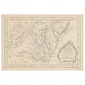 BELLIN, JACQUES. CARTE DE LA
 VIRGINIE, DE LA BAYE CHESAPEACK ET PAYS VOISINS... ...Pour servir à l'Histoire Générale des Voyages (1757), copperplate engraving with no color, depicts Virginia, Maryland and the Chesapeake Bay region; behind mat in gilt wooden frame.
BELLIN, JACQUES. CARTE DE LA
BELLIN, JACQUES. CARTE DE LA VIRGINIE, DE LA BAYE CHESAPEACK ET PAYS VOISINS... ...Pour servir à l'Histoire Générale des Voyages (1757), copperplate engraving with no color, depicts Virginia, Maryland and the Chesapeake Bay region; behind mat in gilt wooden frame. -
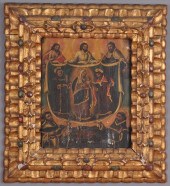
 Virgin and Child with Saints
 Dominic and Catherine, oilette; 20 1/2\" x 14 1/2; unsigned. Several small tears
Virgin and Child with Saints
Virgin and Child with Saints Dominic and Catherine, oilette; 20 1/2\" x 14 1/2; unsigned. Several small tears -
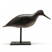 EASTERN SHORE VIRGINIA YELLOWLEGS
 Eastern Shore Virginia, circa 1920, carved and painted wood, mounted on metal stand.
EASTERN SHORE VIRGINIA YELLOWLEGS
EASTERN SHORE VIRGINIA YELLOWLEGS Eastern Shore Virginia, circa 1920, carved and painted wood, mounted on metal stand. -
 Map of Part of Virginia and Florida
 Amsterdam, 17th Century, Virginiae partis Australis, et Floridae orientalis, interjacentiumqus regionum Nova D
Map of Part of Virginia and Florida
Map of Part of Virginia and Florida Amsterdam, 17th Century, Virginiae partis Australis, et Floridae orientalis, interjacentiumqus regionum Nova D -
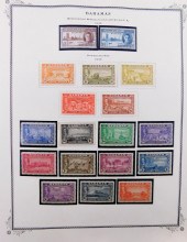 STAMPS: EXTENSIVE COLLECTION OF
 CARIBBEAN BRITISH COMMONWEALTH OF NATIONS, IN A COMBINATION OF SCOTTS INTERNATIONAL AND KA-BE STAMP ALBUMS, THE FOLLOWING COUNTRIES ARE INCLUDED: ST. LUCIA, ST. VINCENT, TRINIDAD AND TO...STAMPS: Extensive collection of Caribbean British commonwealth of nations, in a combination of Scotts International and KA-BE stamp albums, the following countries are included: St. Lucia, St. Vincent, Trinidad and Tobago, Montserrat, Turks and Caicos, Bahamas, Virgin Islands, Antigua, St. Helena, Tristan de Cunha, St. Christopher, Nevis, most albums date between 1950 and 1980.
STAMPS: EXTENSIVE COLLECTION OF
STAMPS: EXTENSIVE COLLECTION OF CARIBBEAN BRITISH COMMONWEALTH OF NATIONS, IN A COMBINATION OF SCOTTS INTERNATIONAL AND KA-BE STAMP ALBUMS, THE FOLLOWING COUNTRIES ARE INCLUDED: ST. LUCIA, ST. VINCENT, TRINIDAD AND TO...STAMPS: Extensive collection of Caribbean British commonwealth of nations, in a combination of Scotts International and KA-BE stamp albums, the following countries are included: St. Lucia, St. Vincent, Trinidad and Tobago, Montserrat, Turks and Caicos, Bahamas, Virgin Islands, Antigua, St. Helena, Tristan de Cunha, St. Christopher, Nevis, most albums date between 1950 and 1980. -
 Southeastern United States map by
 D'Anville D'Anville Jean Baptiste Bourguignon. PARTIE MERIDIONALE DE LA LOUISIANE AVEC LA FLORIDE LA CAROLINE ET LA VIRGINIE. Santini and Remondini. Venice: n.d. circa 1784. With coloring. plate size: H19 3/8'' W23'' Staining along center crease; foxing to margins and verso; 1/4'' tear along center crease at top; abrasion at upper right of cartouche.
Southeastern United States map by
Southeastern United States map by D'Anville D'Anville Jean Baptiste Bourguignon. PARTIE MERIDIONALE DE LA LOUISIANE AVEC LA FLORIDE LA CAROLINE ET LA VIRGINIE. Santini and Remondini. Venice: n.d. circa 1784. With coloring. plate size: H19 3/8'' W23'' Staining along center crease; foxing to margins and verso; 1/4'' tear along center crease at top; abrasion at upper right of cartouche. -
 18th century map, eastern United
 States, "Virginia Marylandia et Carolina, in America Septentrionali, Brittanorum industria exclutae…" by Johann Baptist Homann, originally published in Homann's Atlas Novus , Nuremberg, Germany, 1714, showing New York southward to the Carolinas, fictional "Apalache Lacus" pictured lower left, ornate title cartouche lower right showing British merchants with trade goods, Native Americans, wild animals, tobacco and drying shed, hand-colored engraving on laid paper, 19-3/4 x 23 in. (page); modern wood frame. Laid down on acidic card, foxing, toning, stains, fading, trimmed including plate marks, ink inscriptions in title cartouche, other pencil and ink inscriptions; frame with abrasions. Estate of the Late Nathan and Mary Anne McCarley, Asheville, North Carolina.
18th century map, eastern United
18th century map, eastern United States, "Virginia Marylandia et Carolina, in America Septentrionali, Brittanorum industria exclutae…" by Johann Baptist Homann, originally published in Homann's Atlas Novus , Nuremberg, Germany, 1714, showing New York southward to the Carolinas, fictional "Apalache Lacus" pictured lower left, ornate title cartouche lower right showing British merchants with trade goods, Native Americans, wild animals, tobacco and drying shed, hand-colored engraving on laid paper, 19-3/4 x 23 in. (page); modern wood frame. Laid down on acidic card, foxing, toning, stains, fading, trimmed including plate marks, ink inscriptions in title cartouche, other pencil and ink inscriptions; frame with abrasions. Estate of the Late Nathan and Mary Anne McCarley, Asheville, North Carolina. -
 TWO STAMP ALBUMS, CONSISTING OF:
 JERSEY ISLANDS AND GUERNSEYTwo Stamp Albums, Consisting of: Jersey Islands and Guernsey
TWO STAMP ALBUMS, CONSISTING OF:
TWO STAMP ALBUMS, CONSISTING OF: JERSEY ISLANDS AND GUERNSEYTwo Stamp Albums, Consisting of: Jersey Islands and Guernsey -
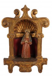 SPANISH COLONIAL NICHE WITH
 VIRGIN MARYcarved and painted wood Condition: with chips and loss consistent with age; crown of figure held in place with tape; beetle holes to figure 18 1/2 x 11 1/2 inches Condition:
SPANISH COLONIAL NICHE WITH
SPANISH COLONIAL NICHE WITH VIRGIN MARYcarved and painted wood Condition: with chips and loss consistent with age; crown of figure held in place with tape; beetle holes to figure 18 1/2 x 11 1/2 inches Condition: -
 Eleven books on Virginia to include
 The Mansions of Virginia and other related subjects.
Eleven books on Virginia to include
Eleven books on Virginia to include The Mansions of Virginia and other related subjects. -
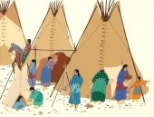 VIRGINIA STROUD, UNTITLED (WOMEN AT
 WORK BY TIPIS), 1983Virginia Stroud, (Cherokee-Muscogee Creek, b. 1951) Untitled (Women at Work by Tipis), 1983, gouache on paper signed and dated lower right: Virginia A Stroud 1983 © GGGS gouache on paper Dimensions: 19 x 24 1/2 in. (48.26 x 62.23 cm.), Framed: Provenance: Private Collection, California
VIRGINIA STROUD, UNTITLED (WOMEN AT
VIRGINIA STROUD, UNTITLED (WOMEN AT WORK BY TIPIS), 1983Virginia Stroud, (Cherokee-Muscogee Creek, b. 1951) Untitled (Women at Work by Tipis), 1983, gouache on paper signed and dated lower right: Virginia A Stroud 1983 © GGGS gouache on paper Dimensions: 19 x 24 1/2 in. (48.26 x 62.23 cm.), Framed: Provenance: Private Collection, California -
 VIRGINIA AND MARYLAND, TWO
 REPRODUCTION COLOR PRINT MAPSVirginia and Maryland, Two Reproduction Color Print Maps
VIRGINIA AND MARYLAND, TWO
VIRGINIA AND MARYLAND, TWO REPRODUCTION COLOR PRINT MAPSVirginia and Maryland, Two Reproduction Color Print Maps -
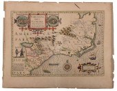
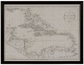 Map of the West Indies, London 1794
 "An Accurate Map of the West Indies with the Adjacent Coast of America", by J. Russell, from Winterbotham's View of the United States, published by H. D. Symonds, London, 1794, showing islands of the Caribbean, 14-1/2 x 19-3/4 in. (sight), modern wood frame,
Map of the West Indies, London 1794
Map of the West Indies, London 1794 "An Accurate Map of the West Indies with the Adjacent Coast of America", by J. Russell, from Winterbotham's View of the United States, published by H. D. Symonds, London, 1794, showing islands of the Caribbean, 14-1/2 x 19-3/4 in. (sight), modern wood frame, -
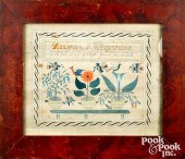 VIRGINIA PEN, INK, AND WATERCOLOR
 FRAKTURBerkeley, Virginia pen, ink, and watercolor fraktur , inscribed Zilpha J. McIntire the daughter of John and Jane McIntire was born in the year of our Lord, March the eleventh, 1815 , with birds and potted flowers, in a period painted pine frame, 9 1/2" x 11 3/4". Competitive in-house shipping is available for this lot. Condition: Small stains, 1 1/2'' loss to right edge, minor foxing. Not examined out of frame.
VIRGINIA PEN, INK, AND WATERCOLOR
VIRGINIA PEN, INK, AND WATERCOLOR FRAKTURBerkeley, Virginia pen, ink, and watercolor fraktur , inscribed Zilpha J. McIntire the daughter of John and Jane McIntire was born in the year of our Lord, March the eleventh, 1815 , with birds and potted flowers, in a period painted pine frame, 9 1/2" x 11 3/4". Competitive in-house shipping is available for this lot. Condition: Small stains, 1 1/2'' loss to right edge, minor foxing. Not examined out of frame.
...many more examples with full details are available to our members - Learn more
Easy & Visual methods to Identify & Appraise Antiques & Collectibles
EASY. FAST. ACCURATE.
Research at its best
We are here to help!
Our research tools include:

Thousands of makers marks for PORCELAIN, POTTERY CHINAWARE, FIGURINES, VASES
see details...

Thousands of marks & hallmarks for SILVER & JEWELRY, PEWTER, PRECIOUS METALS, SILVERPLATE
see details...
