Pricing Guides & Dictionary of Makers Marks for Antiques & Collectibles
Appraise and find values for
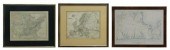
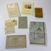
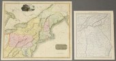
(3) MAPS: UNITED STATES, MARTHA'S...
From
marks4antiques.com
- The most updated price guide and makers' marks research online
As a member, you have access to a team of experts
and assistance is always available to you for free
An example from the millions of items in our Price Guide:
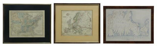
(3) MAPS: UNITED STATES, MARTHA'S VINEYARD, EUROPE(lot of 3) Framed maps, including: (1) Martha's Vineyard, U.S. Geological Survey, sight: 10.25"h,...
This is an example from our
values4antiques price guide
We do not buy or sell any items
See more price guides
Check our other research services:
IDENTIFY WORLDWIDE MAKERS' MARKS & HALLMARKS
marks4ceramics:
Porcelain, Pottery, Chinaware, Figurines, Dolls, Vases...
marks4silver
:
Silver, Jewelry, Pewter, Silverplate, Copper & Bronze...
Explore other items from our
Antiques & Collectibles Price Guide
-
 A LATE MEXICAN-AMERICAN WAR ERA MAP, "MA
[more like this]
A LATE MEXICAN-AMERICAN WAR ERA MAP, "MA
[more like this]
-
 A Very Large Collection of Maps, 19th/e
[more like this]
A Very Large Collection of Maps, 19th/e
[more like this]
-
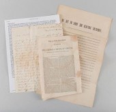 TN CIVIL WAR BROADSIDE, PAMPHLET, LETTER
[more like this]
TN CIVIL WAR BROADSIDE, PAMPHLET, LETTER
[more like this]
-
 WILLIAM WINTERBOTHAM. AN HISTORICAL, GEO
[more like this]
WILLIAM WINTERBOTHAM. AN HISTORICAL, GEO
[more like this]
-
 MITCHELL. A NEW UNIVERSAL ATLAS CONTAINI
[more like this]
MITCHELL. A NEW UNIVERSAL ATLAS CONTAINI
[more like this]
-
 A Large Collection of Maps of America,
[more like this]
A Large Collection of Maps of America,
[more like this]
-
 A Large Collection of Maps of Various Re
[more like this]
A Large Collection of Maps of Various Re
[more like this]
-
 MARTHA VISSER'T HOOFT "POLTERGEIST #2" 1
[more like this]
MARTHA VISSER'T HOOFT "POLTERGEIST #2" 1
[more like this]
-
 5 CIVIL WAR MAPSLot of five Civil War ma
[more like this]
5 CIVIL WAR MAPSLot of five Civil War ma
[more like this]
-
 8 TENNESSEE MILITARY & SURVEY MAPSAssort
[more like this]
8 TENNESSEE MILITARY & SURVEY MAPSAssort
[more like this]
-
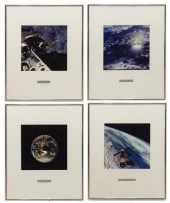 (4) PHOTOGRAPHIC PRINTS OF SPACE BY ASTR
[more like this]
(4) PHOTOGRAPHIC PRINTS OF SPACE BY ASTR
[more like this]
-
 4 vols. (Pennsylvania Property Atlases
[more like this]
4 vols. (Pennsylvania Property Atlases
[more like this]
-
 1 vol. (Philadelphia Atlas.) Smedley, S
[more like this]
1 vol. (Philadelphia Atlas.) Smedley, S
[more like this]
-
 DU HALDE, Jean-Baptiste, (French, 1674-1
[more like this]
DU HALDE, Jean-Baptiste, (French, 1674-1
[more like this]
-
 2 FRAMED 18TH C. FADEN MAPS - GREECE & D
[more like this]
2 FRAMED 18TH C. FADEN MAPS - GREECE & D
[more like this]
-
 HENRY MOUZON - MAP OF NORTH AND SOUTH CA
[more like this]
HENRY MOUZON - MAP OF NORTH AND SOUTH CA
[more like this]
-
 AN ANTIQUE MAP, "CARTE DES VARIATIONS DE
[more like this]
AN ANTIQUE MAP, "CARTE DES VARIATIONS DE
[more like this]
-
 (3) MAPS: UNITED STATES, MARTHA'S VINEYA
[more like this]
(3) MAPS: UNITED STATES, MARTHA'S VINEYA
[more like this]
-
 NATIVE AMERICAN/WESTERN U.S. EXPEDITION
[more like this]
NATIVE AMERICAN/WESTERN U.S. EXPEDITION
[more like this]
-
 8 BOOKS, SEWING, NEEDLEPOINT, EMBROIDERY
[more like this]
8 BOOKS, SEWING, NEEDLEPOINT, EMBROIDERY
[more like this]
-
 MARTHA CAHOON, PAIR POLYCHROME FOLK ART
[more like this]
MARTHA CAHOON, PAIR POLYCHROME FOLK ART
[more like this]
-
 MARTHA STURDY VANCOUVER MODERN BRASS AND
[more like this]
MARTHA STURDY VANCOUVER MODERN BRASS AND
[more like this]
-
 MARTHA STURDY VANCOUVER MODERN RUNWAY BE
[more like this]
MARTHA STURDY VANCOUVER MODERN RUNWAY BE
[more like this]
-
 STEPHANIE RHOADES + MARTHA ARQUERO, GROU
[more like this]
STEPHANIE RHOADES + MARTHA ARQUERO, GROU
[more like this]
-
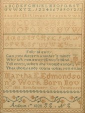 MONTGOMERY CO. TENNESSEE SAMPLERMontgome
[more like this]
MONTGOMERY CO. TENNESSEE SAMPLERMontgome
[more like this]
-
 COLLECTION OF LEDOUX'S MAPS AND CATALOGS
[more like this]
COLLECTION OF LEDOUX'S MAPS AND CATALOGS
[more like this]
-
 COLLECTION OF LEDOUX'S MAPS AND CATALOGS
[more like this]
COLLECTION OF LEDOUX'S MAPS AND CATALOGS
[more like this]
-
 5 CIVIL WAR RELATED BOOKS1st item: Hopki
[more like this]
5 CIVIL WAR RELATED BOOKS1st item: Hopki
[more like this]
-
 MARTHA SLAYMAKER, INDIANA / NEW MEXICO (
[more like this]
MARTHA SLAYMAKER, INDIANA / NEW MEXICO (
[more like this]
-
 CHRIS CALLE (B. 1961) "MICRONESIA"Chris
[more like this]
CHRIS CALLE (B. 1961) "MICRONESIA"Chris
[more like this]
-
 2 UNITED STATES MAPS, INCLUDING 1817.2 U
[more like this]
2 UNITED STATES MAPS, INCLUDING 1817.2 U
[more like this]
-
 MAP AND ATLAS LOT, 3 PCS INCL. MELISH DI
[more like this]
MAP AND ATLAS LOT, 3 PCS INCL. MELISH DI
[more like this]
-
 (6) MITCHELL & BRADLEY ATLAS MAPS NEW YO
[more like this]
(6) MITCHELL & BRADLEY ATLAS MAPS NEW YO
[more like this]
-
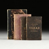 A GROUP OF FOUR BOOKS WITH MAPS OF TEXAS
[more like this]
A GROUP OF FOUR BOOKS WITH MAPS OF TEXAS
[more like this]
-
 2 vols. (Philadelphia Property Atlases.
[more like this]
2 vols. (Philadelphia Property Atlases.
[more like this]
-
 7 vols. Cartography: Brown, Lloyd A. Th
[more like this]
7 vols. Cartography: Brown, Lloyd A. Th
[more like this]
This list is limited to only a few results.
Many more items are available to our members in our
Price Guide!
Ideal research tools for Collectors, Personal Property Appraisers, Antiques & Collectibles
Dealers, Auction Houses, Museums, eBayers or
other online
sellers (Rubylane, Etsy etc) and curious minds interested in appraising & identifying collectibles

EASY. FAST. ACCURATE.
Research at its best

Our research tools include:


