Pricing Guides & Dictionary of Makers Marks for Antiques & Collectibles
Appraise and find values for
TWO MAPS OF ILLINOIS AND CIVIL...
From
marks4antiques.com
- The most updated price guide and makers' marks research online
As a member, you have access to a team of experts
and assistance is always available to you for free
An example from the millions of items in our Price Guide:

TWO MAPS OF ILLINOIS AND CIVIL WAR BATTLEFIELDS, FRAME OF LARGER: 30 X 24 IN. (76.20 X 60.96 CM.)Two Maps of Illinois and Civil War Battlefields,,...
This is an example from our
values4antiques price guide
We do not buy or sell any items
See more price guides
Check our other research services:
IDENTIFY WORLDWIDE MAKERS' MARKS & HALLMARKS
marks4ceramics:
Porcelain, Pottery, Chinaware, Figurines, Dolls, Vases...
marks4silver
:
Silver, Jewelry, Pewter, Silverplate, Copper & Bronze...
Explore other items from our
Antiques & Collectibles Price Guide
-
 A Very Large Collection of Maps, 19th/e
[more like this]
A Very Large Collection of Maps, 19th/e
[more like this]
-
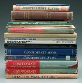 Civil War firearms related books: George
[more like this]
Civil War firearms related books: George
[more like this]
-
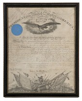 Capt. George Randolph Dyer AQM--Lincoln-
[more like this]
Capt. George Randolph Dyer AQM--Lincoln-
[more like this]
-
 Brevet Brigadier General James M. Ruggle
[more like this]
Brevet Brigadier General James M. Ruggle
[more like this]
-
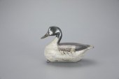 THE CHEESEMAN GOLDENEYE DRAKEVerne Chees
[more like this]
THE CHEESEMAN GOLDENEYE DRAKEVerne Chees
[more like this]
-
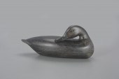 THE PERDEW PREENING BLACK DUCKCharles Pe
[more like this]
THE PERDEW PREENING BLACK DUCKCharles Pe
[more like this]
-
 8 TENNESSEE MILITARY & SURVEY MAPSAssort
[more like this]
8 TENNESSEE MILITARY & SURVEY MAPSAssort
[more like this]
-
 5 CIVIL WAR MAPSLot of five Civil War ma
[more like this]
5 CIVIL WAR MAPSLot of five Civil War ma
[more like this]
-
 17 BOOKS ON AMERICAN CIVIL RIGHTS, SOME
[more like this]
17 BOOKS ON AMERICAN CIVIL RIGHTS, SOME
[more like this]
-
 DU HALDE, Jean-Baptiste, (French, 1674-1
[more like this]
DU HALDE, Jean-Baptiste, (French, 1674-1
[more like this]
-
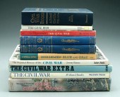 Ten books, Civil War related: Tom Broadf
[more like this]
Ten books, Civil War related: Tom Broadf
[more like this]
-
 5 CIVIL WAR RELATED BOOKS1st item: Hopki
[more like this]
5 CIVIL WAR RELATED BOOKS1st item: Hopki
[more like this]
-
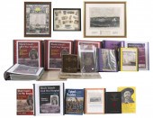 EXTENSIVE AND UNIQUE COLLECTION OF MEMOR
[more like this]
EXTENSIVE AND UNIQUE COLLECTION OF MEMOR
[more like this]
-
 AN ANTIQUE MAP, "CARTE DES VARIATIONS DE
[more like this]
AN ANTIQUE MAP, "CARTE DES VARIATIONS DE
[more like this]
-
 4 vols. (Pennsylvania Property Atlases
[more like this]
4 vols. (Pennsylvania Property Atlases
[more like this]
-
 1 vol. (Philadelphia Atlas.) Smedley, S
[more like this]
1 vol. (Philadelphia Atlas.) Smedley, S
[more like this]
-
 MITCHELL. A NEW UNIVERSAL ATLAS CONTAINI
[more like this]
MITCHELL. A NEW UNIVERSAL ATLAS CONTAINI
[more like this]
-
 2 FRAMED 18TH C. FADEN MAPS - GREECE & D
[more like this]
2 FRAMED 18TH C. FADEN MAPS - GREECE & D
[more like this]
-
 HENRY MOUZON - MAP OF NORTH AND SOUTH CA
[more like this]
HENRY MOUZON - MAP OF NORTH AND SOUTH CA
[more like this]
-
 A Large Collection of Maps of America,
[more like this]
A Large Collection of Maps of America,
[more like this]
-
 7 vols. Cartography - American Subjects
[more like this]
7 vols. Cartography - American Subjects
[more like this]
-
 (5) TEXAS MAPS, 1850'S<br>(lot of 5
[more like this]
(5) TEXAS MAPS, 1850'S<br>(lot of 5
[more like this]
-
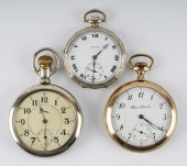 THREE ILLINOIS WATCH CO. POCKET WATCHESt
[more like this]
THREE ILLINOIS WATCH CO. POCKET WATCHESt
[more like this]
-
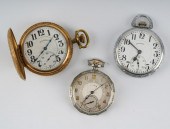 THREE ILLINOIS WATCH CO. POCKET WATCHESt
[more like this]
THREE ILLINOIS WATCH CO. POCKET WATCHESt
[more like this]
-
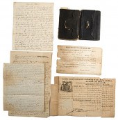
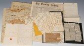 CIVIL WAR AND RELATED DOCUMENTSGrouping
[more like this]
CIVIL WAR AND RELATED DOCUMENTSGrouping
[more like this]
-
 CARTE DE VISITE ALBUM, "STONEWALL" JACKS
[more like this]
CARTE DE VISITE ALBUM, "STONEWALL" JACKS
[more like this]
-
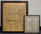 TWO MAPS OF ILLINOIS AND CIVIL WAR BATTL
[more like this]
TWO MAPS OF ILLINOIS AND CIVIL WAR BATTL
[more like this]
-
 6 MISSISSIPPI AND TENNESSEE RIVER MAPSSi
[more like this]
6 MISSISSIPPI AND TENNESSEE RIVER MAPSSi
[more like this]
-
 Military Maps Illustrating the Operation
[more like this]
Military Maps Illustrating the Operation
[more like this]
-
 2 vols. (Philadelphia Property Atlases.
[more like this]
2 vols. (Philadelphia Property Atlases.
[more like this]
-
 7 vols. Cartography: Brown, Lloyd A. Th
[more like this]
7 vols. Cartography: Brown, Lloyd A. Th
[more like this]
-
 1782 Thomas Kitchen atlas, A General Atl
[more like this]
1782 Thomas Kitchen atlas, A General Atl
[more like this]
-
 THE LIFE OF GEORGE WASHINGTON, BY JOHN M
[more like this]
THE LIFE OF GEORGE WASHINGTON, BY JOHN M
[more like this]
-
 MAPS: JOHN SPEED (ENGLAND, 1552-1629), T
[more like this]
MAPS: JOHN SPEED (ENGLAND, 1552-1629), T
[more like this]
-
 MAPS: JOHN MARSHALL "THE LIFE OF GEORGE
[more like this]
MAPS: JOHN MARSHALL "THE LIFE OF GEORGE
[more like this]
-
 7 EARLY TENNESSEE GEOLOGICAL REPORTS, IN
[more like this]
7 EARLY TENNESSEE GEOLOGICAL REPORTS, IN
[more like this]
This list is limited to only a few results.
Many more items are available to our members in our
Price Guide!
Ideal research tools for Collectors, Personal Property Appraisers, Antiques & Collectibles
Dealers, Auction Houses, Museums, eBayers or
other online
sellers (Rubylane, Etsy etc) and curious minds interested in appraising & identifying collectibles

EASY. FAST. ACCURATE.
Research at its best

Our research tools include:


