Pricing Guides & Dictionary of Makers Marks for Antiques & Collectibles
Appraise and find values for
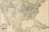
WINONA MN MAP SHOBER AND CHICAGO...
From
marks4antiques.com
- The most updated price guide and makers' marks research online
As a member, you have access to a team of experts
and assistance is always available to you for free
An example from the millions of items in our Price Guide:
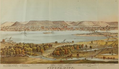
WINONA MN MAP SHOBER AND CHICAGO LITHOGRAPH CO.Lithograph depicting a bird's eye view of the city of Winona, Minnesota. Created by Charles Shober and...
This is an example from our
values4antiques price guide
We do not buy or sell any items
See more price guides
Check our other research services:
IDENTIFY WORLDWIDE MAKERS' MARKS & HALLMARKS
marks4ceramics:
Porcelain, Pottery, Chinaware, Figurines, Dolls, Vases...
marks4silver
:
Silver, Jewelry, Pewter, Silverplate, Copper & Bronze...
Explore other items from our
Antiques & Collectibles Price Guide
-
 BRITANNIA, VOL. I & II CAMDEN 1722Camden
[more like this]
BRITANNIA, VOL. I & II CAMDEN 1722Camden
[more like this]
-
 A COMPLETE SYSTEM OF GEOGRAPHY, VOL. I B
[more like this]
A COMPLETE SYSTEM OF GEOGRAPHY, VOL. I B
[more like this]
-
 IMPORTANT ANTIQUE ATLAS DU VOYAGE DE LA
[more like this]
IMPORTANT ANTIQUE ATLAS DU VOYAGE DE LA
[more like this]
-
 5 KENTUCKY AND TENNESSEE MAPS1st item: "
[more like this]
5 KENTUCKY AND TENNESSEE MAPS1st item: "
[more like this]
-
 WINONA MN MAP SHOBER AND CHICAGO LITHOGR
[more like this]
WINONA MN MAP SHOBER AND CHICAGO LITHOGR
[more like this]
-
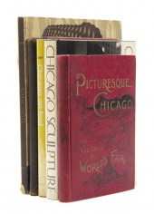 * (CHICAGO) A group of 16 books pertaini
[more like this]
* (CHICAGO) A group of 16 books pertaini
[more like this]
-
 3 KY & TN MAPS: VANCE, TANNER, JOHNSON1s
[more like this]
3 KY & TN MAPS: VANCE, TANNER, JOHNSON1s
[more like this]
-
 A RARE ANTIQUE CIVIL WAR ERA MAP, "PRESS
[more like this]
A RARE ANTIQUE CIVIL WAR ERA MAP, "PRESS
[more like this]
-
 4 TN & KY MAPS, 3 FRAMED1st item: "Tenne
[more like this]
4 TN & KY MAPS, 3 FRAMED1st item: "Tenne
[more like this]
-
 8 TENNESSEE MILITARY & SURVEY MAPSAssort
[more like this]
8 TENNESSEE MILITARY & SURVEY MAPSAssort
[more like this]
-
 CHARLES WILLIAM DAHLGREEN, ILLINOIS, IND
[more like this]
CHARLES WILLIAM DAHLGREEN, ILLINOIS, IND
[more like this]
-
 A Very Large Collection of Maps, 19th/e
[more like this]
A Very Large Collection of Maps, 19th/e
[more like this]
-
 A TOPOGRAPHICAL MAP OF THE ENVIRONS OF L
[more like this]
A TOPOGRAPHICAL MAP OF THE ENVIRONS OF L
[more like this]
-
 11 PC. MAP COLLECTION: Comprising; 1- La
[more like this]
11 PC. MAP COLLECTION: Comprising; 1- La
[more like this]
-
 16TH / 18TH C. EUROPEAN MAPS OF NEW SPAI
[more like this]
16TH / 18TH C. EUROPEAN MAPS OF NEW SPAI
[more like this]
-
 3 19TH CENT. AL, KY, & TN MAPS1st item:
[more like this]
3 19TH CENT. AL, KY, & TN MAPS1st item:
[more like this]
-
 MAP AND ATLAS LOT, 3 PCS INCL. MELISH DI
[more like this]
MAP AND ATLAS LOT, 3 PCS INCL. MELISH DI
[more like this]
-
 A LATE MEXICAN-AMERICAN WAR ERA MAP, "MA
[more like this]
A LATE MEXICAN-AMERICAN WAR ERA MAP, "MA
[more like this]
-
 AN IMPORTANT REPUBLIC OF TEXAS MAP, "MAP
[more like this]
AN IMPORTANT REPUBLIC OF TEXAS MAP, "MAP
[more like this]
-
 AN ANTIQUE RECONSTRUCTION ERA MAP, "KOSS
[more like this]
AN ANTIQUE RECONSTRUCTION ERA MAP, "KOSS
[more like this]
-
 5 CIVIL WAR MAPSLot of five Civil War ma
[more like this]
5 CIVIL WAR MAPSLot of five Civil War ma
[more like this]
-
 MINNEAPOLIS MAP SHOBER AND CHICAGO LITHO
[more like this]
MINNEAPOLIS MAP SHOBER AND CHICAGO LITHO
[more like this]
-
 ELLEN LANYON, NEW YORK, ILLINOIS / ENGLA
[more like this]
ELLEN LANYON, NEW YORK, ILLINOIS / ENGLA
[more like this]
-
 AN ANTIQUE MAP, "NEW RAILROAD MAP OF THE
[more like this]
AN ANTIQUE MAP, "NEW RAILROAD MAP OF THE
[more like this]
-
 CIVIL WAR, CHAS. SHOBER CHICAGO LITHOGRA
[more like this]
CIVIL WAR, CHAS. SHOBER CHICAGO LITHOGRA
[more like this]
-
 NATIVE AMERICAN/WESTERN U.S. EXPEDITION
[more like this]
NATIVE AMERICAN/WESTERN U.S. EXPEDITION
[more like this]
-
![[Railroads] Railroads and Road](/images/railroads-railroads-and-roads--15f0a8-medium.jpg) [Railroads] Railroads and Roads - Bookle
[more like this]
[Railroads] Railroads and Roads - Bookle
[more like this]
-
 WINONA CRAWFORD (NC, 1928-2019), WOMAN
[more like this]
WINONA CRAWFORD (NC, 1928-2019), WOMAN
[more like this]
-
 WINONA CRAWFORD (NC, 1928-2019), WOMAN
[more like this]
WINONA CRAWFORD (NC, 1928-2019), WOMAN
[more like this]
-
 RARE 1865 MONTANA TERRITORY MAP BY W.W.
[more like this]
RARE 1865 MONTANA TERRITORY MAP BY W.W.
[more like this]
-
 * (CHICAGO) A group of five books. The G
[more like this]
* (CHICAGO) A group of five books. The G
[more like this]
-
 GRP: MODERN AND CONTEMPORARY ART BOOKSLa
[more like this]
GRP: MODERN AND CONTEMPORARY ART BOOKSLa
[more like this]
-
 4 EARLY AMERICAN MAPS: OVERTON, THIERRY,
[more like this]
4 EARLY AMERICAN MAPS: OVERTON, THIERRY,
[more like this]
-
 * (CHICAGO LITERATURE) A group of 10 tit
[more like this]
* (CHICAGO LITERATURE) A group of 10 tit
[more like this]
-
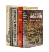 * (CHICAGO) A group of five works. The G
[more like this]
* (CHICAGO) A group of five works. The G
[more like this]
-
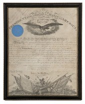 Capt. George Randolph Dyer AQM--Lincoln-
[more like this]
Capt. George Randolph Dyer AQM--Lincoln-
[more like this]
This list is limited to only a few results.
Many more items are available to our members in our
Price Guide!
Ideal research tools for Collectors, Personal Property Appraisers, Antiques & Collectibles
Dealers, Auction Houses, Museums, eBayers or
other online
sellers (Rubylane, Etsy etc) and curious minds interested in appraising & identifying collectibles

EASY. FAST. ACCURATE.
Research at its best

Our research tools include:


